Search
HIPPO III: Research Flight 02 - Northern Polar Region
March 26, 2010
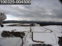
 The crew seemed particularly excited about the northern polar flight, from Anchorage, AK to 85° north, back to Anchorage. The prospects of seeing the data in real-time while flying over this amazing landscape had both the pilots and scientists buzzing with excitement pre-flight.
Data collection went smooth, and all instruments were working properly. Unfortunately, no polar bears were sighted in the polar regions. However, the crew aboard the GV was treated to an amazing view of Mt. McKinley and the surrounding Alaskan topography.
Two missed approaches were performed during Research Flight 02: one at Fairbanks Airport (FAI) and another at Dead horse Airport (SCC), near Prudhoe Bay, Alaska. Once over the sea-ice, three more dips were performed, and none were performed once they turned back towards Anchorage, AK at 85° north, to conserve fuel enabling them to fly as far north as they did. The dips and missed approaches allow the scientist to collect data of vertical profiles of the atmosphere. The flight was able to reach 85° north due to the direct linear flight plan, which is the farthest north that the HIPPO crew has flown to sample the atmosphere. The aircraft is unable to fly to 90° north, or the North Pole because they need to be able to fly out and back from Anchorage, AK safely on one load of fuel.
.jpeg "GV preparing for a landing in Anchorage, AK after the polar flight") GV preparing for a landing in Anchorage, AK after the polar flight |
.jpeg "GV appraoching the Anchorage, AK airportat the end of RF02") GV appraoching the Anchorage, AK airportat the end of RF02 |
.jpeg "Sea Ice & Left Wing Instruments") Sea Ice & Left Wing Instruments |
.jpeg "Denali") Denali |
.jpeg "Harvard team at 85° north") Harvard team at 85° north |
.jpeg "Inlet Shadows") Inlet Shadows |
.jpeg "Missed approach at Deadhorse Airport, AK") Missed approach at Deadhorse Airport, AK |
.jpeg "Missed approach at Deadhorse Airport, AK") Jasna Pitmann working on the CO2 Instrument |
.jpeg "Northern Alaska") Northern Alaska |
.jpeg "Northern Alaska") Northern Alaska |
VIDEO: HIPPO III RF02 from Forward Looking Camera
HIPPO III: Research Flight 01 - Colorado to Alaska
March 24, 2010: RF01
 The first of 11 HIPPO III research flights left from Broomfield, Colorado aproximately 12:30pm heading to Anchorage, AK. Due to delays in the flight schedule, the flight plan only incorporated 2 dips along the way which were performed as missed approaches at airports in Edmonton, Alberta, Canada and Watson Lake, Yukon Territory, Canada.
FAA regulations do not allow flights to fly below 1000' over land, so in order for the HIPPO study to collect samples at low altitudes they must do a missed approach at an airport. Missed approaches are when the aircraft is fully prepared to land at an airport, but just prior to landing the aircarft gains altitude again, intentionally missing the landing. This way the instruments on the aircraft can collect air samples at low levels of the atmoshphere. The image to the right was taken with the forward looking camera as it starts a missed approach at the Watson Lake Airport. In fact, some of the crew saw a moose when they did the missed approach!
|
|
|
|
.jpeg "Jonathan Bent checking the AO2 instrument")
.jpeg "Flying high over the Canadian Rockie")
.jpeg "Arriving in Anchorage, AK")
VIDEO: HIPPO III RF01 Flight
HIPPO II: Flight 10 - Northern Polar Regions
November 21, 2009
 Research Flight #10 (RF10) was completed and was a success. The NSF/NCAR GV reached 83º North and completed five dips including low approach in Fairbanks. All of the dips were to 500 ft and all were over the recently formed ice cover with occasional large cracks, some of which showed open water. Interesting contaminated air masses were observed on the out-bound leg of the flight. On the return leg, the NSF/NCAR GV climbed to 45,000 feet and entered stratospheric air with high concentrations of ozone. High temperatures in the stratosphere (-41C) did not allow the NSF/NCAR GV to reach altitudes higher than 45,000', even though the pilots tried.
Despite the combined effort of the entire crew and the use of night vision goggles, no polar bear sightings were reported. (Bummer...perhaps next time). Snowfall and darkness at the last dip at 83º North did not allow the team to spot for bears in the Polar night, so after completing the last 500 ft level leg, they turned around and headed back for Anchorage. Unfortunately, they did not return far enough South in time to see a second sunrise of the day as the crew was able to in January. The moonrise was reportedly quite nice, however.
Video: RF10 Forward Looking Camera
HIPPO II: Flight 09 - Kona, HI to Anchorage, AK
November 19, 2009
 Research Flight 9 flew from Kona, Hawaii to Anchorage, AK and completed the planned 6 dips during the flight, and for the most part, followed the same flight path as RF03, the reverse southbound flight. The flight was approximately 2400 nmi and almost 8 hours.
All of the images from the forward looking camera during this flight can be found in the HIPPO II Field Catalog.
The day before each flight, the HIPPO Team gets together on a teleconference to discuss the status of the status of the NSF/NCAR GV, operational topics as well as to look at the weather forecast of the flight plan for the next day. You can see the weather forecast for the flight from Kona to Anchorage, as well as the forecast for the following days.
Global Coordination Center
The purpose of the Global Campaign Coordination and Communications Center is to serve as the main communications and coordination hub between the PIs and the aircraft in the field. It will resemble a small operations center. It is important to note that HIPPO will range across 8 time zones and the International Date Line during the 21 day deployment. This will require flexibility in schedules and support to meet the needs of the aircraft mission. The major task of the Coordination Center will be to accumulate and distribute up-to-date information on mission planning, operations, science and logistics, in particular:
- Aircraft status
- Instrumentation status, RAF, PI and user
- Weather products and predicted conditions
- Chemical model output products
- Real-time in-flight contact and coordination, as required
- General project logistics
A team of EOL staff and interested PIs will be in the Center to support all aspects of the HIPPO deployment. A group of people representing these components will gather on a daily basis in person or teleconference. These people will also be present in the Center or on call during aircraft operations to assist with any questions or issues from the aircraft. The representatives are:
- Brigitte Baeuerle, Vidal Salazar - Global Operations Center Coordinator
- Al Cooper - EOL Aircraft Scientific Lead
- Karen Rosenloff, Eric Ray (NOAA/ESRL) - Project forecasters
- Steve Wofsy (PI, will call in from remote locations when possible)
- Pavel Romashkin (Aircraft Ops PM, will call in from remote locations when possible)
- Vidal Salazar (Ground Ops PM, will call in from remote locations when possible)
- Greg Stossmeister (Field Catalog)
- Bob Olson or designee - Aircraft maintenance
- Kurt Zrubek or designee - Instrumentation
- Scotty McClain or designee - Pilot, help with flight planning, changes etc. if needed
- Chris Webster or designee - SE
- (Contact information for all science groups to report immediate instrument issues)
We plan to have a HIPPO Daily Status Update Meeting during the field phase beginning on 5 January 2009 through 28 January 2009. The timing of the meeting each day may be adjusted to allow attendance by the participants deployed with the aircraft. The purpose of the meeting is to ensure that all Center representatives and personnel deployed with the aircraft are aware of all happenings since the last meeting, and to share any updated information they may have received directly at the Center. In addition it is documented in the operations part of the Field Catalog.
The Daily Meeting will include:
- Aircraft status
- Instrumentation status
- Weather and Chemistry brief
- Plans and schedules for the next 24-48 hours
- Logistics update
The status meeting will start with aircraft and instrumentation status. This will allow the technical staff to participate and leave, or stay if they choose to. The following discussion of the chemical and weather forecasts is intended to be brief but can be flexible as needed.
All information contained in the Daily Meeting will be posted to the HIPPO Field Catalog or on the RAF HIPPO Web site. The catalog will be updated at least once a day following this meeting and more often as changing conditions or status warrant. This will help ensure that anyone can see the status of HIPPO operations and facilities from anywhere, assuming they have access to the Internet. This includes all interested science groups, groups traveling to the main support stations (i.e. Anchorage, AK, Christchurch, NZ and San Jose, CR) with information such as aircraft delays, or particular instrument problems that may require bringing a critical spare into the field to the next support location.
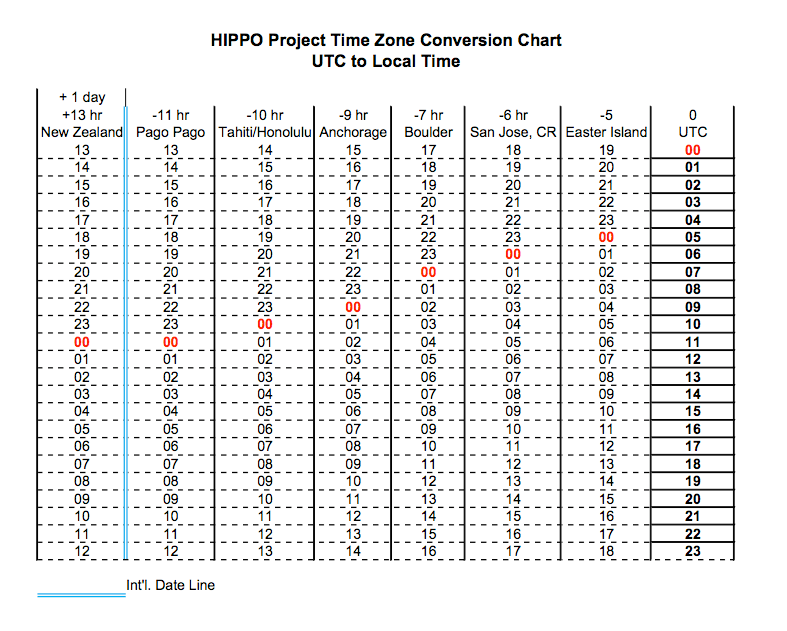
Time Conversion Chart
Below is a simple chart that shows all of the time zones we will visit during the upcoming HIPPO deployment. It includes a column of the 24 UTC time with conversions to all local time zones. Note that we will effectively range across 7 time zones and the International Date Line. Shown in red is the 'midnight' for UTC and local midnight for all local time zones.

HIPPO II: Flight 06 - Southern Polar Regions
November 12, 2009
The NSF/NCAR GV and the HIPPO team had yet another successful flight towards the South Pole.
The NSF/NCAR GV was routed to the East of their original flight plan, in order to avoid a weather system located directly South of New Zealand to prevent potential icing of instruments. This route allowed the GV to reach 66° South. The aircraft completed 6 dips along the way.
 Floating ice was first noticed at approximately 63° South, then again on dip number 5. The crew has decided to cut down on the altitude of the last ascent but perform one extra dip, number 6, in order to sample air in the boundary layer over the forming ice. This was the farthest point of the flight and the GV had to turn back at that time.
The turn at 500 feet above sea level was performed flawlessly by the pilots and the GV flew above cracked ice fields, with all people onboard taking numerous pictures, collecting measurements in the boundary layer.
Interestingly, they saw two or three seals on the ice that stayed close to large cracks with open water. No penguins, maybe next time!
 After the final turn the GV began a gradual climb to 43,000 feet and returned to Christchurch three hours later. The overpass of the Lauder observatory was cancelled due to overcast conditions at Lauder, which made ground based observations impossible. The samples taken in flight over Lauder would have been used in conjunction with the ground observations giving them a "complete column" sample, so without the ground based observations the fly over samples would have been moot.


Video: RF06 Forward Looking Camera
HIPPO II: Flight 05 - Rarotonga, CI to Christchurch, NZ
November 9, 2009
 The HIPPO project had a great flight from Rarotonga, Cook Islands to Christchurch, New Zealand and performed 7 dips during the 7 hour flight.
One of the dips icluded a fly over at New Zealand's National Institute of Water and Atmospheric Research's (NIWA) atmospheric research station at Lauder, in Central Otago, New Zealand. A New Zealand news website, The Scoop, states "The Lauder site is part of the global Total Carbon Column Observing Network (TCCON), Measurements from this network of 14 key sites worldwide will aid understanding of the global carbon cycle and will validate new satellite-borne measurements of carbon dioxide and methane from space.
HIAPER will descend from an altitude of 14 km to just 300 meters above the ground when it flies over Lauder, measuring a profile of greenhouse gases from the stratosphere down to the Earth's surface. At the same time NIWA scientists at Lauder will be measuring the concentration of these gases at the earth's surface and the "total column" overhead.
The HIAPER flight over New Zealand provides a unique opportunity to perform an important calibration of new ground based, remote sensing measurements of greenhouse gases,says Dr Vanessa Sherlock, leader of NIWA's TCCON research project. "We will then compare these measurements with the aircraft profile to determine the calibration of the ground based measurements to the World Meteorological Organisation scale. In this way surface measurements and total column measurements from the ground and space can be combined in a consistent way to improve our understanding o future greenhouse gas concentration." says Dr Sherlock." Read the full story on the The Scoop.
During its flight the GV crossed the international dateline, landing in Christchurch New Zealand at around 4:00 pm November 10 - after only a seven-hour flight. Convert these times to your local time.
Christchurch is the gateway to Antarctica, as well as a one of the largest cities on the HIPPO route. The stop in Christchurch allows for any needed maintenance that perhaps could not be performed at smaller locations, and positions the GV to fly as far south as possible and return safely on one load of fuel.
HIPPO II: Flight 04 - Kona, HI to Rarotonga, CI
November 7, 2009
 The GV flew from Kona, Hawaii to Rarotonga, Cook Islands, after completing RF04 (Research Flight #4) with 8 dips along the way, last dip being 100 miles east of America Samoa. You can see the 8 dips and the flight path in the image above from Google Earth.
Explore all of the days' images from the NSF/NCAR GV's forward-camera that is mounted under the left wing.
Despite the rain, the HIPPO crew is still planning on having an outreach event where close to 20 people are expected to attend to learn more about the HIPPO project and the modified GV.
 The image to the left was taken as the NSF/NCAR GV was approaching Rarotonga, and you can see plumes of pollution from the biomass burning on the island.
Rarotonga is a very friendly destination for aircraft operations. The hotel is right on the beach and very good; internet connectivity is not very fast and costs extra but not unreasonable. All groups are able to get online for data submissions. The pool is full of kids playing and getting wet from both the pool water and pouring rain.
The next stop is Christchurch, with departure from Rarotonga Monday, November 9 at 1000 and approximately 7 hour flight duration.