Search
HIPPO III: Research Flight 08 - American Samoa to Hawaii
|
April 10, 2010
Check out all of the forward looking camera images in the HIPPO III Field Catalog, in the Research Products section. Feel free to poke around the field catalog, as there is an amazing amount of information such as pre-flight weather discussions. The HIPPO Project Manager, Pavel Romashkin, reported seeing a whale on a low dip just after they crossed the equator at 4° north! This was the first time that they have seen a whale during a HIPPO campaign, and hope that it is not their last! On another note, the pilots planned the approach into Kona so that, in descent, the GV flew in a spiral around the northeast side of Hawaii, descending through the air that the Mauna Loa observatory would sample an hour later. The island was covered by clouds on the East and by vog (volcanic fog, a typical occurrence for Kona) on the west, and they could see the steam rising from the place where lava flows into the ocean, forming a long band of clouds extending for miles downwind. |

HIPPO III: Research Flight 07 - New Zealand to American Samoaoa
April 8, 2010
 The start of Research Flight 07 marks the beginning of the return flight back towards the North Pole, and then home to Colorado. The flight was 2300 miles and they were able to complete 5 dips along the way.
All instruments were up and operational, as you can see in the HIPPO III Field Catalog Instrument Status Report. If you want to learn more about the various instruments, there is wonderful information on this website in the Research Instruments section.
HIPPO III: Research Flight 06 - Southern Polar Region
April 5, 2010
 The HIPPO study was able to reach the Antarctic Circle (66° south) during the flight to the southern polar regions, and back to Christchurch, NZ which is the farthest south that the project has been able to study the atmosphere.
The reason that the flight track image above looks like the NSF/NCAR GV only went a short distance away from New Zealand is that the satellite coverage of Google Earth in the southern and northern polar regions is not the best. The track in the image above is the outbound (yellow) and the last hour of the inbound (red) flight linked by a short yellow vertical line.
During the inbound flight, the GV did a fly-over at New Zealand's National Institute of Water and Atmosphere (NIWA) Lauder Reaserch Station, to help provide them with a complete vertical profile of the atmosphere from the ground to the altitude that the GV was flying. So while the GV passed overhead, the ground station took measurements as well, which can collectively provide a complete vertical profile to altitudes that can not be achieved by the ground instruments
.jpeg "Sea Ice Edge Near Antarctic Circle") Sea Ice Edge Near Antarctic Circle |
.jpeg "Sea Ice Edge Near Antarctic Circle") Sea Ice Edge Near Antarctic Circle |
.jpeg "Cloud Uniformity") Cloud Uniformity |
.jpeg "Three Phases of Water : Gas, Liquid, Solid") Three Phases of Water : Gas, Liquid, Solid |
.jpeg "G-V Glory!") GV Glory! |
.jpeg "Banking around to the north at 67° south") Banking around to the north
at 67° south |
.jpeg "Real-time flight track from aircraft monitor") Real-time flight track from aircraft monitor |
.jpeg "Low Pass of NIWA's Lauder Research Station") Low Pass of NIWA's Lauder Research Station |
VIDEO: RF 06 Forward Looking Camera
HIPPO III: Research Flight 05 - American Samoa to NewZealand
April 2, 2010
 Research Flight 05 from Pago Pago, American Samoa to Christchurch, New Zealand completed 5 dips over their 7 hour flight. During the flight they crossed the International Date Line, so they actaully landed in Christchurch on April 4.
Check out all of the forward looking camera images from RF05 in the HIPPO III Field Catalog. Be sure to browse around it and explore some of the other areas such as Daily Reports, Mission notes.
VIDEO: RF 05 Forward Looking Camera
HIPPO III: Research Flight 04 - Hawaii to American Samoa
March 31, 2010
 The NSF/NCAR GV received clearance to climb to 41,000 ft near 5 degrees N, allowing the science team to be the first in HIPPO to get insight into the atmospheric cross section near the Intertropical Convergence Zone (ITCZ). The conversion zone itself was located South of 5°N, and the GV descended right through the middle of it. Turbulence was minimal, and the area did not look "tropical" as people are used to seeing the tropics: it was overcast, with tall clouds everywhere and three to four layered decks of clouds, with overshooting convective towers and anvils at 50,000 feet and above, stretching for many miles. The overcast weather changed to the "tropical" one only by 4°S.
Arriving in Pago Pago, American Samoa, the GV met 89°F weather and high humidity, causing the air conditionning vents in the airplane to start fogging once the doors were open. Moisture immediately condensed on all items taken outside, including people. Their hands were cold, from being in the air conditioned cabin, and water condensed on the skin when they walked out on the ramp!
The flight path consisted of 4 dips over the open ocean and traveled approximately 2540 miles (2207 nautical miles or 4087 km).
.jpeg "Bye, bye: Hawaii!") Bye, bye: Hawaii! |
.jpeg "The G-V flying over the Equator in real-time on Google Earth") The GV flying over the Equator in real-time on Google Earth! |
.jpeg "Intertropical Convergence Zone") Intertropical Convergence Zone |
.jpeg "Intertropical Convergence Zone") Intertropical Convergence Zone |
.jpeg "Clouds in the Southern Hemisphere") Clouds in the Southern Hemisphere |
.jpeg "Hello: American Samoa!") Hello: American Samoa! |
.jpeg "American Samoa!") American Samoa |
.jpeg "Landing in American Samoa") Landing in American Samoa |
.jpeg "The ENTIRE Team in Pago Pago, American Samoa") The ENTIRE Team in Pago Pago, American Samoa |
VIDEO: RF04 Forward Looking Camera
Aerosol Data
Particle data
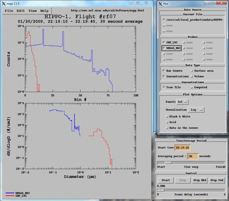
The standard netCDF GV data files that are archived for the project contain both concentration and particle size distribution information from the RAF UHSAS probe (and from CDP and 2D-C, when flown). The probe as operated on HIPPO-1 and HIPPO-2 was not being initialized properly, which caused incorrect mapping of gain stages. This forced RAF to average across 5 bins for the two gain stage overlaps for HIPPO-1. For HIPPO-2 the solution is TBD as the gain stage problem has apparently become worse; further data QC will be conducted.
In order to view concentration data in .nc files, Aeros or any other software capable of viewing time series data in netCDF files can be used.
In order to view size distribution data in .nc files, ncpp should be used. The program will allow to select any or all of the particle probes available in the file and view the data either as particle size distribution or as raw counts:
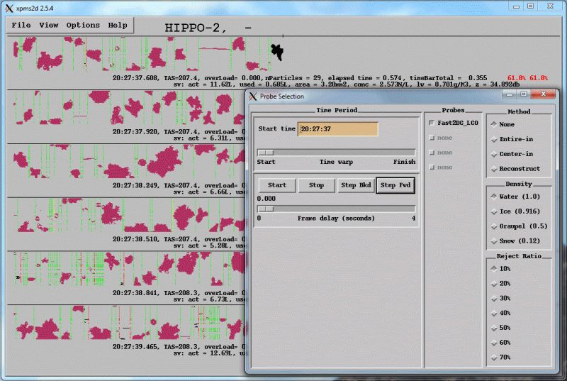
2D image data
On some HIPPO deployments (HIPPO-2 was first), 2D-C probe was flown. This probe produces both calculated size distributions and 2D images. To acces images, 2D data have to be extracted from the raw data files and provided as a separate data product. To view the images, use xpms2d software available from the EOL download center. Example of the images is below.


HIPPO III Research Flight 03 - Alaska to Hawaii

The NSF/NCAR GV took off from the Anchorage Airport and headed west to Cold Bay, where they did a missed approach at the Cold Bay Airport, a main commercial center of the Aleutian Islands. From there, they banked around to the south and headed for Hawaii, and warmer weather. Along the way they did 7 dips (see Google earth flight track in image above) reaching altitudes of just over 500 feet above the ocean surface to heights of 41,000 feet.
.jpeg "Appraoching Cold Bay, AK") Appraoching Cold Bay, AK |
.jpeg "Cold Bay, AK") Cold Bay, AK |
.jpeg "Cold Bay, AK") Cold Bay, AK |
.jpeg "Low dip over Pacific Ocean") Low dip over Pacific Ocean |
|
.jpeg "HIPPO crew taking time to stretch! Appraoching the Big Island, HI") Appraoching the Big Island, HI |
.jpeg "Clouds over Hawaii") Clouds over Hawaii |
.jpeg "Mauna Loa (background) Mona Kea (foreground), HI") Mauna Loa (background) Mona Kea (foreground), HI |
.jpeg "Warm weather!") Warm weather! |
.jpeg "Hawaiian Coast") Hawaiian Coast |
.jpeg "HIPPO crew taking time to stretch!")
VIDEO: RF03 Forward Looking Camera