Search
SOCRATES Project Overview
About SOCRATES
 A team of atmospheric scientists will be based in Hobart, Tasmania for six weeks to collect cloud, aerosol and precipitation data over the Southern Ocean during a research project called the Southern Ocean Clouds, Radiation, Aerosol Transport Experimental Study (SOCRATES).
The U.S. component of SOCRATES’ efforts are funded by the U.S. National Science Foundation (NSF) and supported by the National Center for Atmospheric Research (NCAR). The project is led by Principal Investigators from the University of Oklahoma, University of Washington, and several other U.S. universities. Australian collaborators include scientists and support from the Bureau of Meteorology, the Australian Antarctic Division, and Monash University.
Science serving society
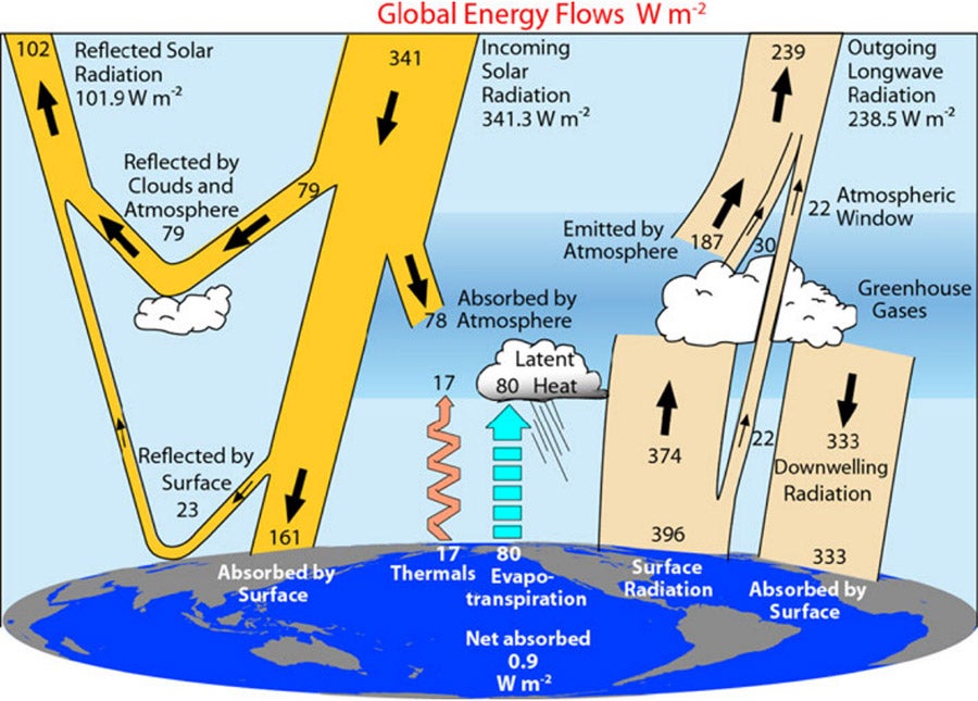 Climate models have a tendency to misrepresent clouds in the Southern Ocean, leading to inaccurate calculations in the energy budget. The data collected during SOCRATES will play a vital role in enhancing computer modeling and forecasting capabilities of weather events and changes in climate across the globe.
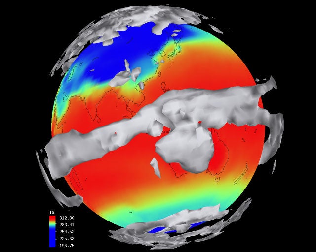
Our current understanding of how clouds form over the Southern Ocean is almost exclusively from satellite observations, which is why more directly observed atmospheric and oceanographic data are needed.
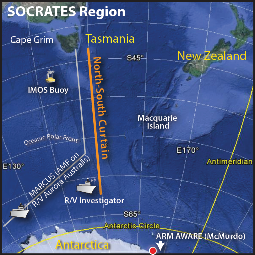
Tasmania as an operations base
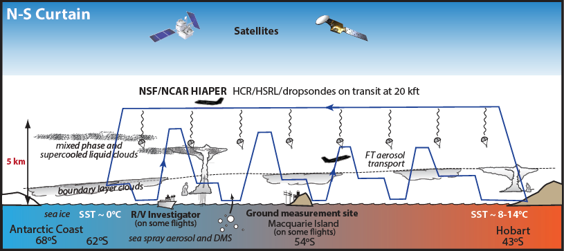
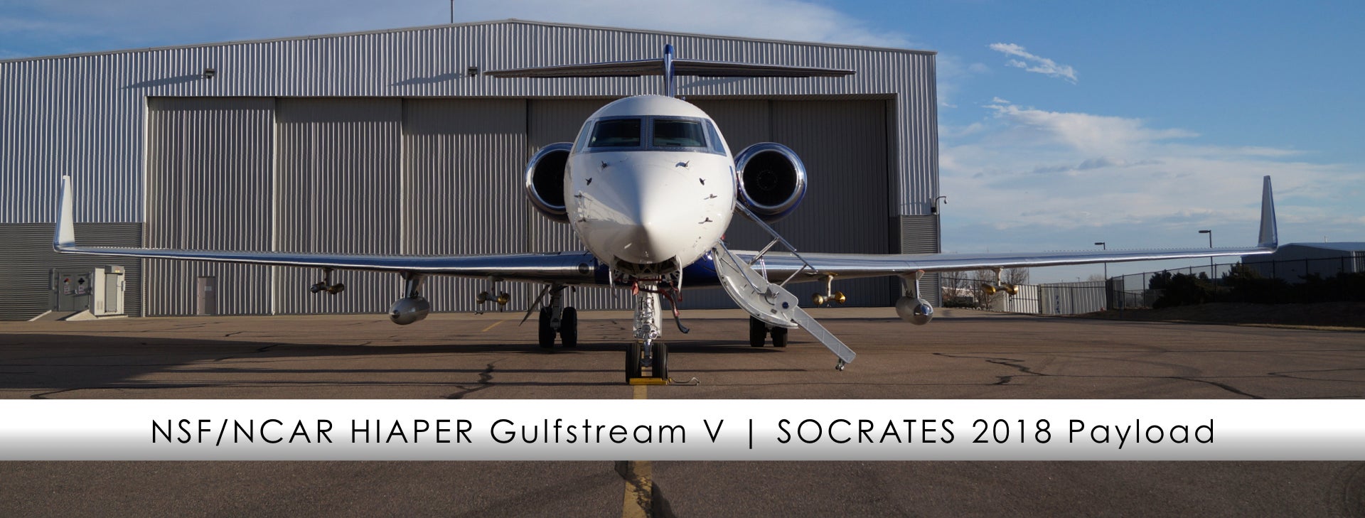
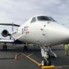
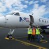
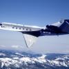
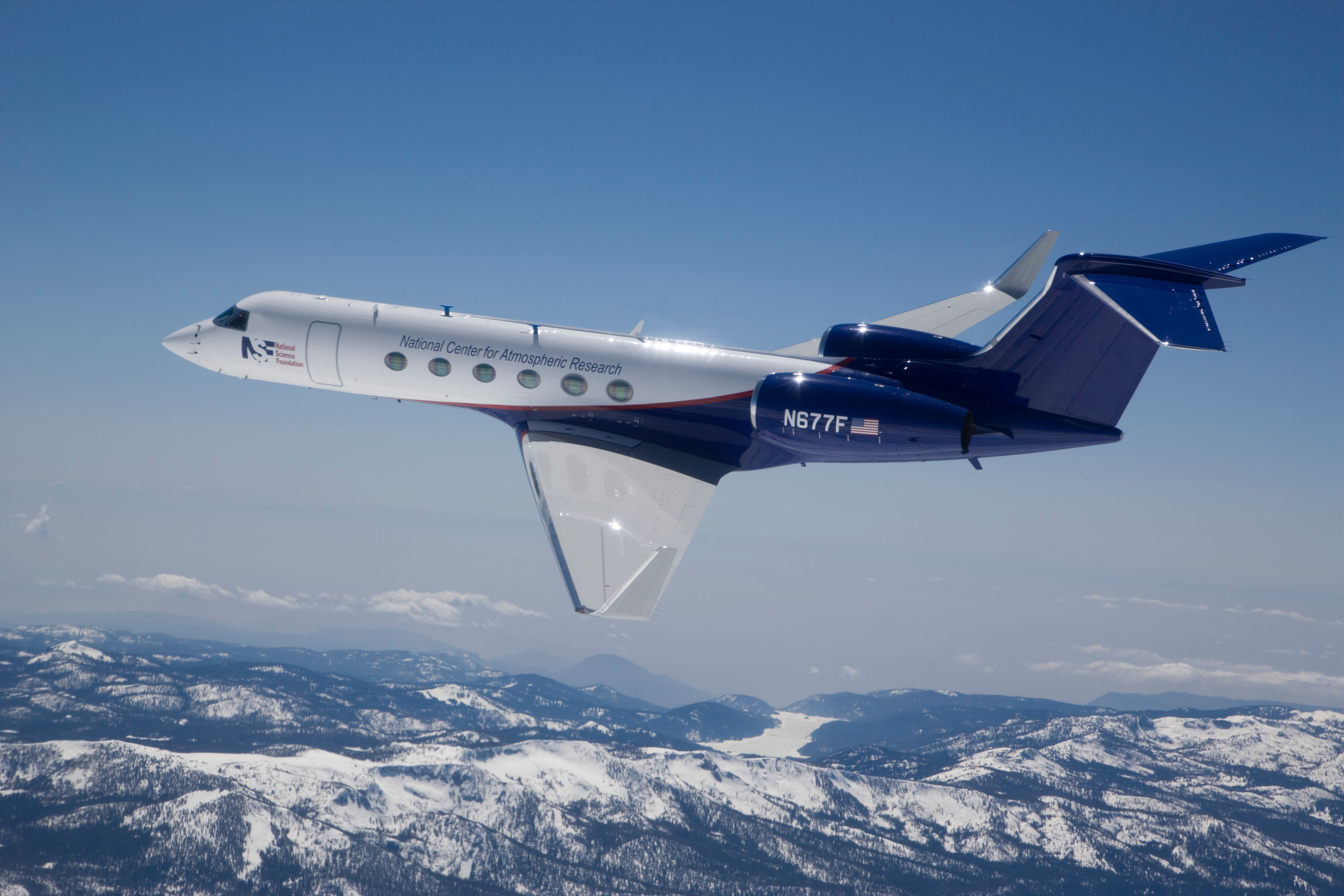
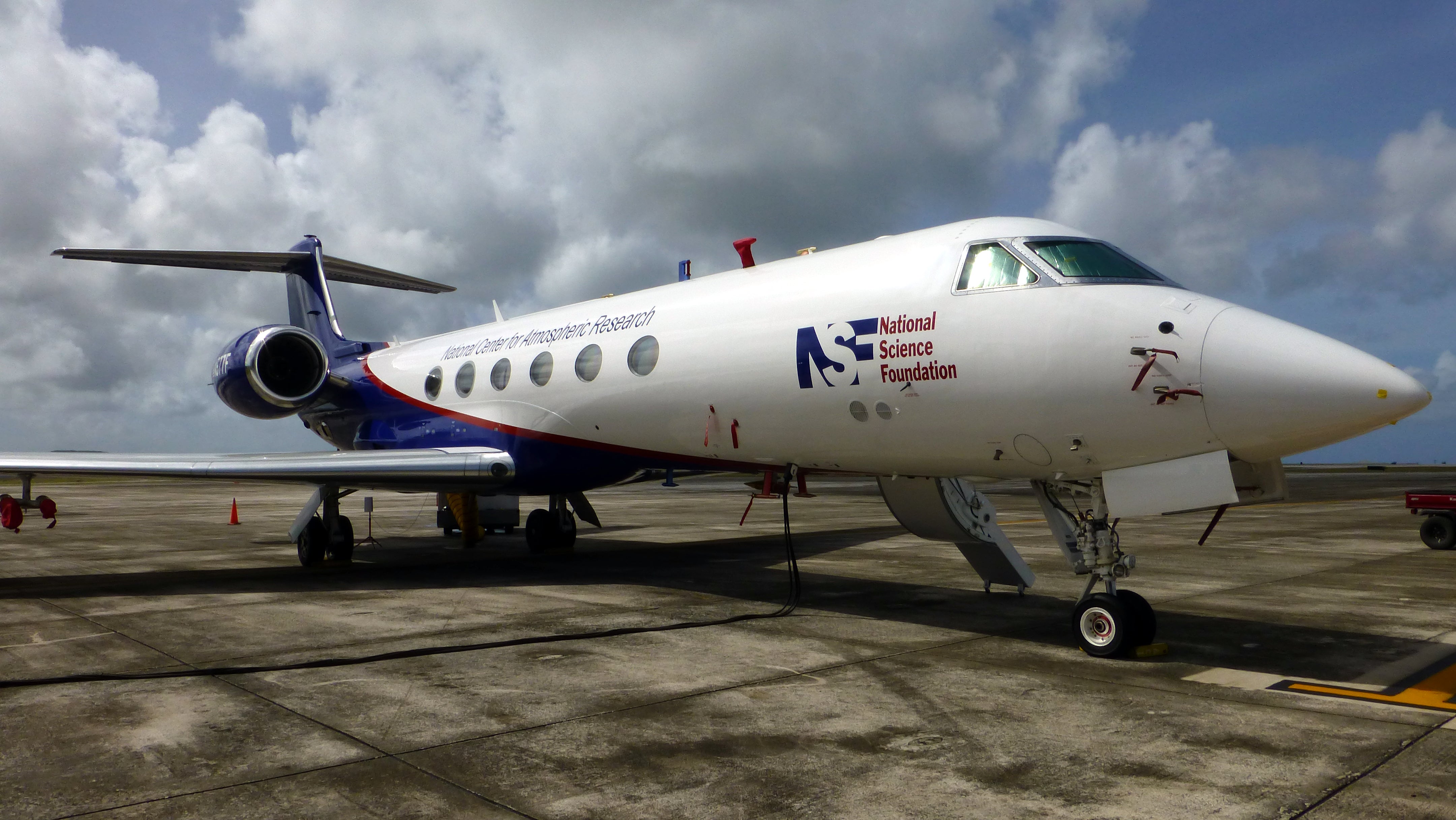
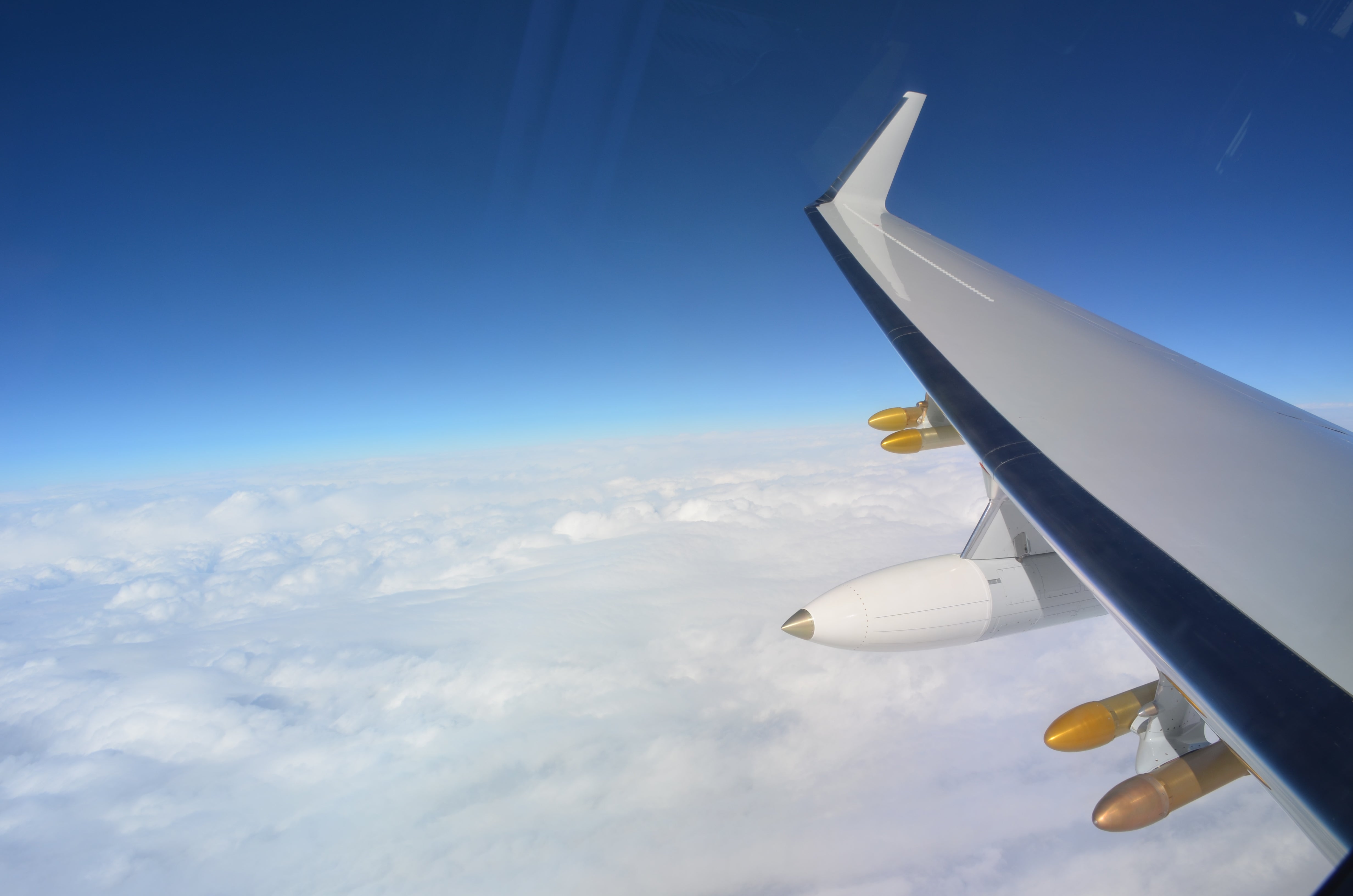
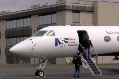
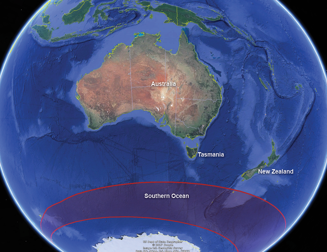 Tasmania’s proximity to the Southern Ocean makes it ideal to serve as the base for the research aircraft, the NSF/NCAR HIAPER (High-performance Instrumented Airborne Platform for Environmental Research) Gulfstream V.
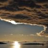
The Southern Ocean is the stormiest place on Earth, churned by winds and waves that circle the ice of Antarctica. This remote and usually pristine environment is typically removed from human-caused and naturally produced continental airborne particles. For this reason, the region is a unique laboratory for studying the interactions between clouds and particles naturally produced by the ocean, such as sea salt and biogenic particles.
Platforms and instrumentation
 Airborne platform and instrumentation
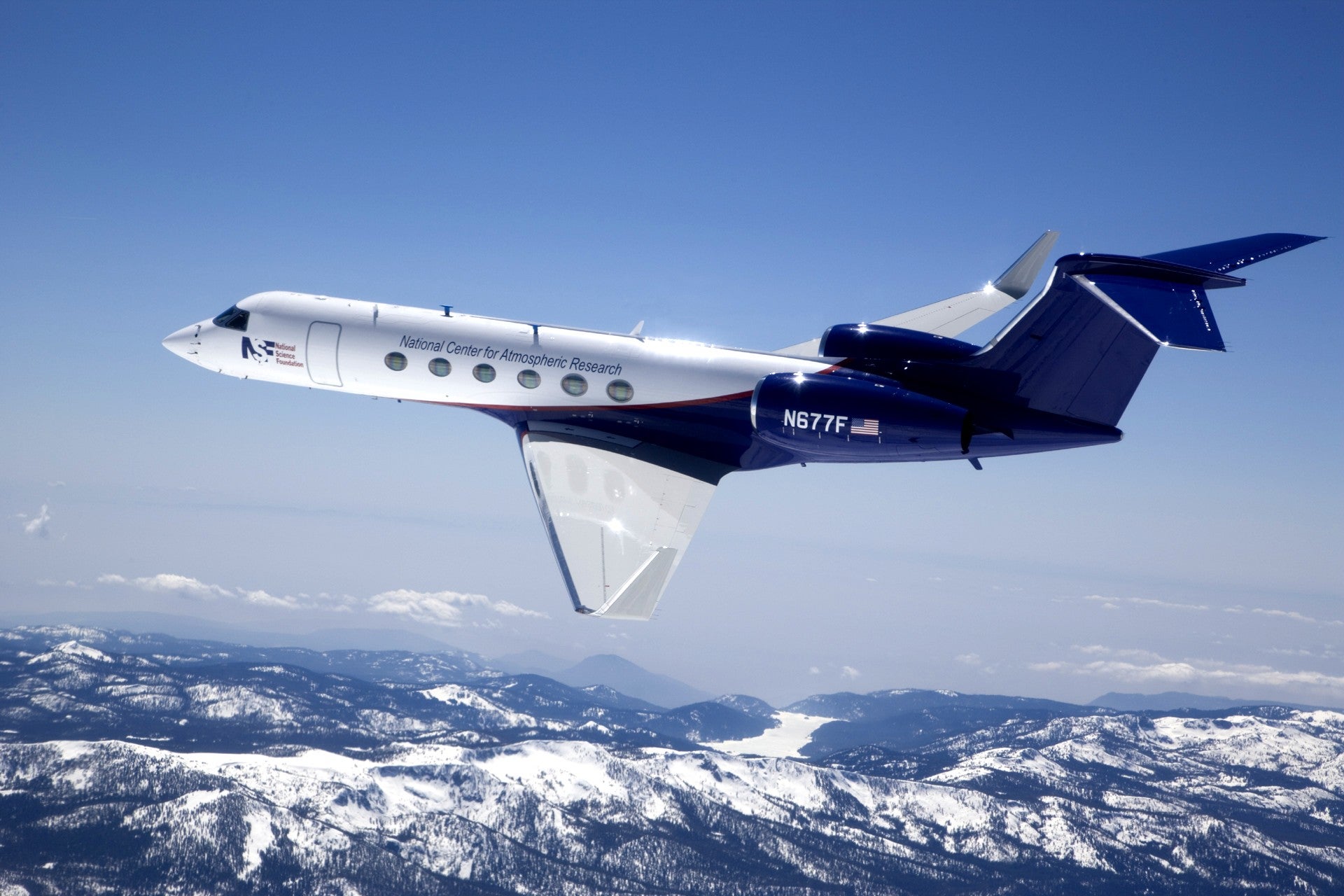
HIAPER is one of the most advanced aircraft for environmental research in the United States. It's owned by the National Science Foundation and operated by NCAR, located in Boulder, Colorado. HIAPER is a Gulfstream V business jet that has been highly modified for scientific research.
HIAPER will be based in Hobart, Tasmania during SOCRATES and is the primary platform to characterize clouds, radiation, aerosols, and precipitation in the domain of interest south of Tasmania. For SOCRATES, HIAPER will fly at various altitudes between 150 - 6000 m above the ocean surface and will carry a suite of instruments specific to this research project including radar, lidar, radiometers, cloud droplet probes, and dropsondes.
Surface platform and ship-based Instrumentation
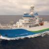
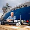
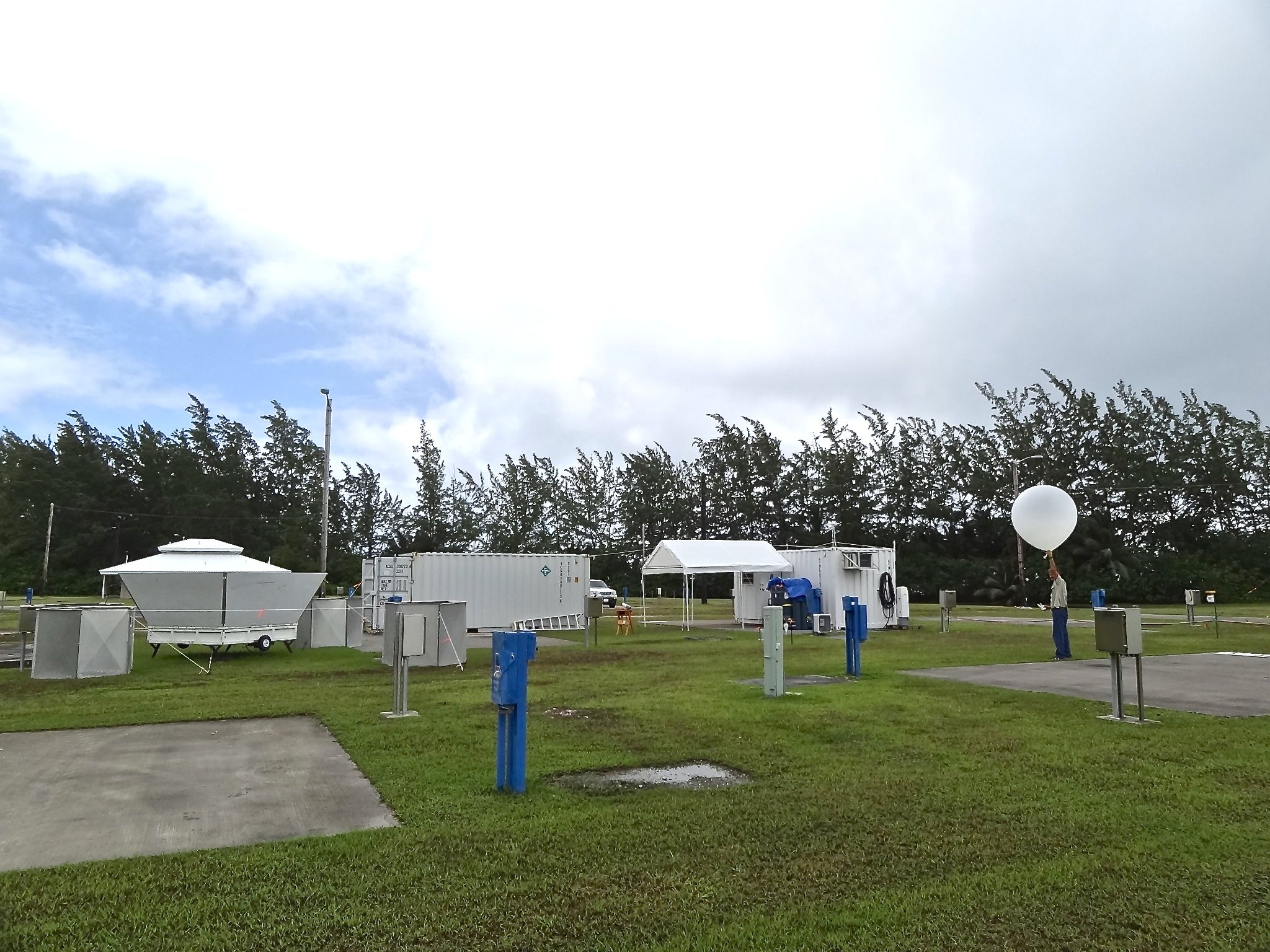
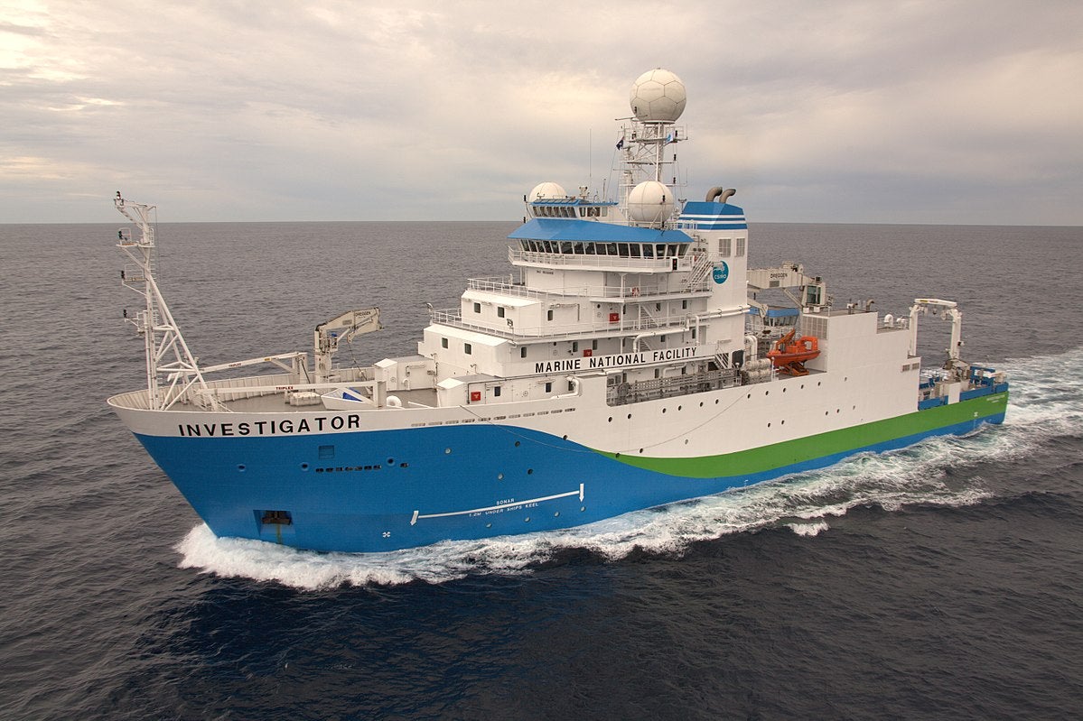 The R/V Investigator, Australia’s only deep-ocean research vessel operated by the Marine National Facility, will carry a suite of instruments to make measurements for SOCRATES during a seven-week cruise. The NCAR Integrated Sounding System (ISS) will be deployed for ocean-atmospheric measurements and consists of a radar wind profiler, surface meteorology sensors, and a balloon-borne radiosonde sounding system. The Australian CAPRICORN (Clouds, Aerosols, Precipitation, Radiation, and Atmospheric Composition over the Southern Ocean) program is supporting ship-based instrumentation that includes cloud and precipitation radars, aerosol and chemical sensors, and seawater sampling to better understand the sources of aerosol from sea-spray.
Measurements taken with on-board the R/V Investigator will be integrated with aircraft and satellite data to provide a complete vertical profile of the atmosphere from the surface up to about 10 km, ultimately providing highly detailed data for enhanced numerical model predictions.


SOCRATES Science Team
| Collaborating Organizations |
 |
| Collaborating Universities |
 |
 |
||
| SOCRATES Principal Investigators |
Greg McFarquhar | University of Oklahoma
 Greg McFarquhar is the Director of the University of Oklahoma Cooperative Institute for Mesoscale Meteorological Studies (CIMMS) and a Professor in their School of Meteorology. McFarquhar comes from the University of Illinois at Urbana-Champaign where he was a faculty member in the Department of Atmospheric Sciences from 2001-2017. He has also served as a visiting faculty fellow at NCAR from 2015 to 2016.
» Read more
Chris Bretherton | University of Washington
 Chris Bretherton is an atmospheric scientist who studies cloud formation and turbulence and improves how they are simulated in global climate and weather forecast models. His research includes participating in field experiments and observational analyses, three-dimensional modeling of fluid flow in and around fields of clouds, and understanding how clouds will respond to and feed back on climate change. Computer code developed by his research group for simulating cloud formation by atmospheric turbulence is used in the two leading U.S. climate models.
» Read more
Robert Wood | University of Washington
 Clouds have fascinated us for thousands of years, but their natural beauty belies a tremendous complexity that continues to elude a complete theoretical understanding. Rob Wood is a physicist who tries to increase that theoretical understanding, studying cloud systems and the meteorological processes that govern them. Using observational data, he builds models of cloud structures and behaviors, exploring the links between clouds and meteorology over the oceans.
» Read more
Roj Marchand | University of Washington
 Dr. Marchand's research focuses on cloud microphysics and improving the representation of clouds in climate and cloud resolving models. This includes developing cloud property retrievals based on satellites and ground-based systems (especially radar), validating retrievals using airborne in situ observations, developing instrument simulators for models, comparing model clouds with retrieved properties, and recently, developing an adaptive vertical grid for cloud resolving models in order to improve the simulation of boundary layer clouds.
» Read more
| SOCRATES Aircraft Instrument PI Teams |
Closed-path Laser Hygrometer, v2 (CLH2)
Darin Toohey: University of Colorado, Boulder, Colorado, U.S.
Cloud Condensation Nuclei (CCN) Counter
Greg Roberts: Scripps Institution of Oceanography, San Diego, California, U.S.
Kevin Sanchez: Scripps Institution of Oceanography, San Diego, California, U.S.
Continuous Flow Diffusion Chambers (CFDC)/Ice Spectrometer (IS)
Paul DeMott: Colorado State University, Fort Collins, Colorado, U.S.
Christina McCluskey: National Center for Atmospheric Research, Boulder, Colorado, U.S.
Counterflow Virtual Impactor (CVI)
Cindy Twohy: NWRA, Scripps Institution of Oceanography, San Diego, California, U.S.
Darin Toohey: University of Colorado, Boulder, Colorado, U.S.
Bryan Rainwater: University of Colorado, Boulder, Colorado, U.S.
Lynn Russell: University of California San Diego / Scripps Institution of Oceanography, San Diego, California, U.S.
Savannah Lewis: University of California San Diego / Scripps Institution of Oceanography, San Diego, California, U.S.
Particle Habit Imager and Polar Nephelometer (PHIPS)
Emma Jarvinen: Karlsruhe Institute of Technology, Germany
Martin Schnaiter: Karlsruhe Institute of Technology, Germany


SOCRATES Facilities & Platforms
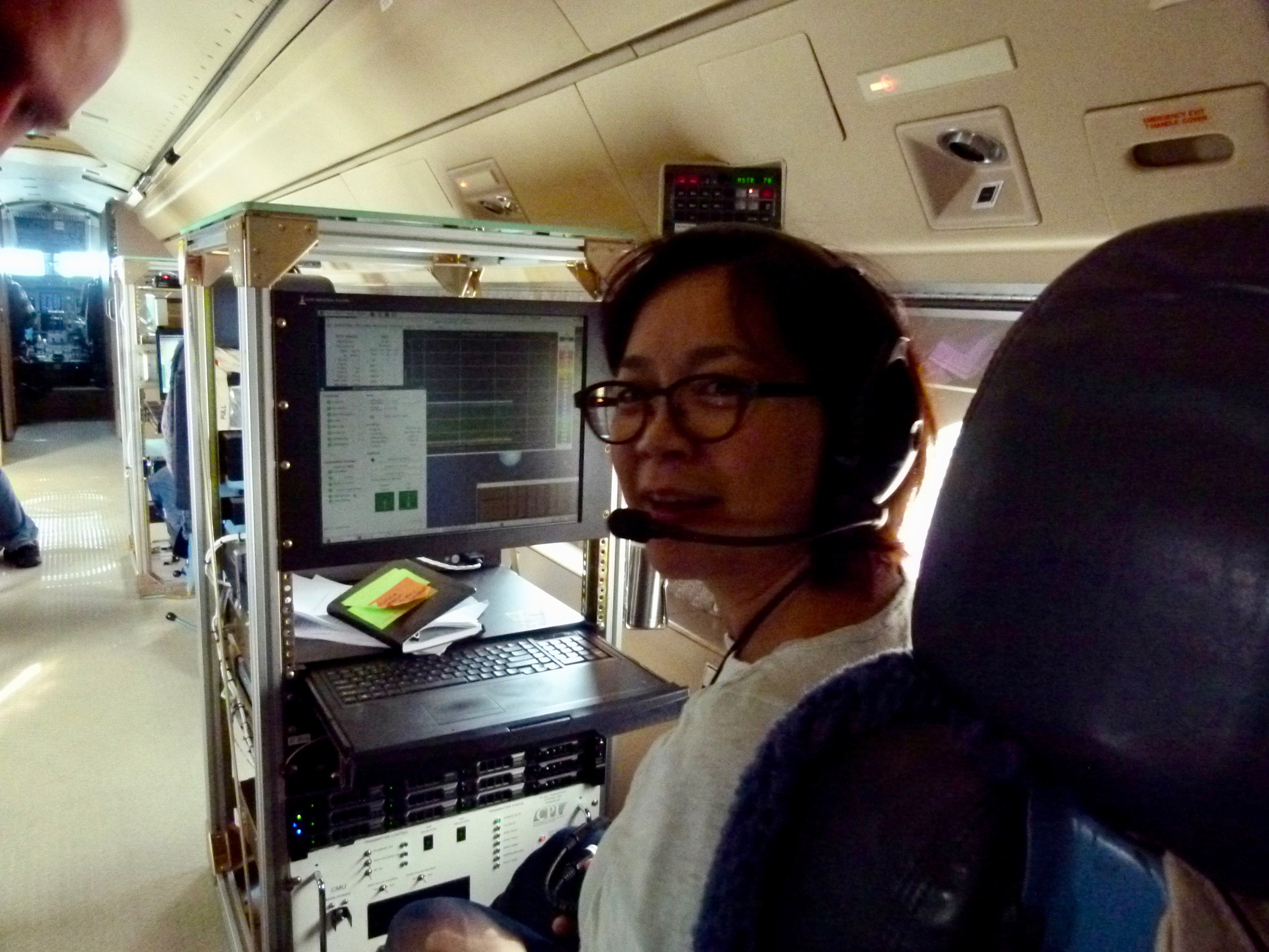
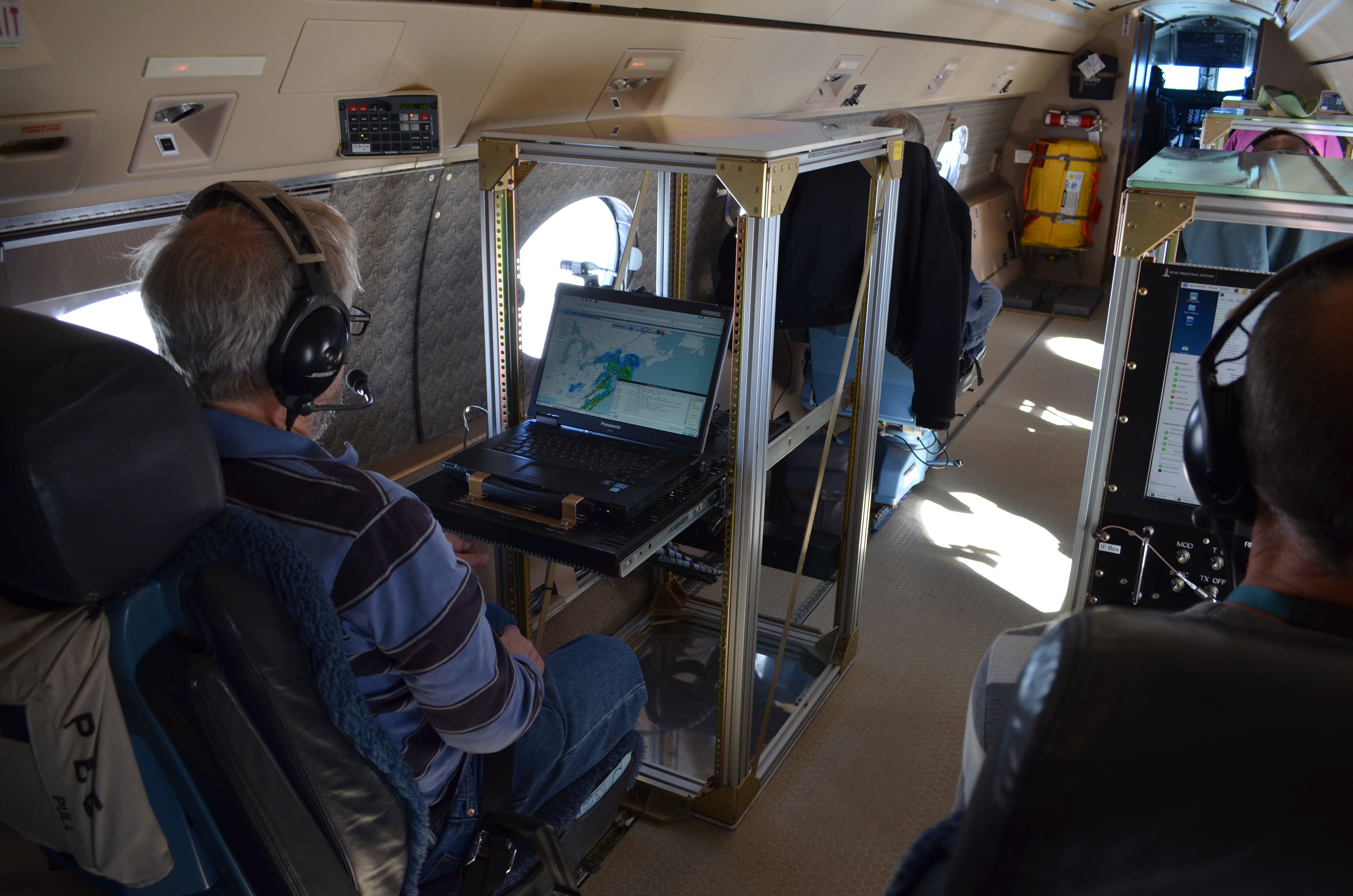
SOCRATES makes use of an instrumented aircraft platform as well as ship-based atmospheric profiling research instrumentation. This comprehensive suite of instruments is used in order to gather data on different types of atmospheric conditions such as cloud dynamics, aerosol size and distribution, winds, and radiation at a range of altitudes.
| RESEARCH AIRCRAFT |
NSF/NCAR HIAPER | High-Altitude Research Aircraft
 The NSF/NCAR HIAPER (High-performance Instrumented Airborne Platform for Environmental Research) is one of the most advanced aircraft for environmental research in the United States. HIAPER is owned by the National Science Foundation and operated by the National Center for Atmospheric Research (NCAR), located in Boulder, Colorado. HIAPER is a Gulfstream V business jet that has been highly modified for scientific research.
The HIAPER will be based in Hobart, Tasmania during SOCRATES and is the primary platform to characterize clouds, radiation, aerosols, and precipitation in the domain of interest south of Tasmania. For SOCRATES, HIAPER will carry a specific suite of instruments that will measure these properties. Capable of flying at altitudes as high as 51,000 feet, HIAPER can collect data at altitudes out of reach of most research aircraft. When the aircraft is flying, follow the flight track live on Google Earth.
» Read more about the NSF/NCAR HIAPER research aircraft
| SHIP-BASED FACILITIES |
Integrated Sounding System (ISS) | Atmospheric Profiling System
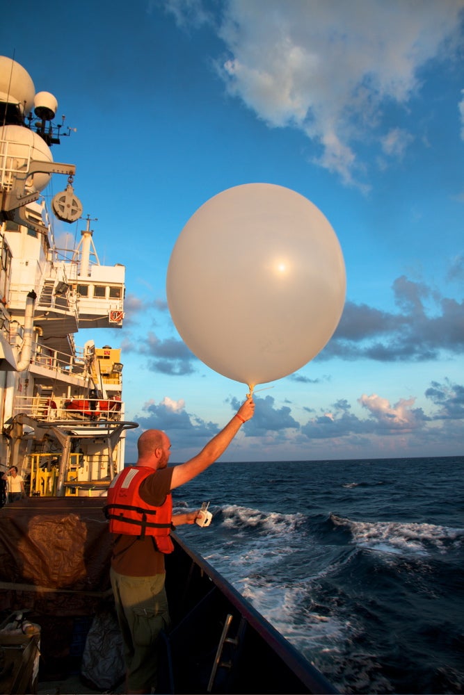 The Integrated Sounding System (ISS) will be deployed aboard the R/V Investigator for ocean-atmospheric studies. The R/V Investigator is Australia’s only blue-water research vessel operated by the Marine National Facility. The ISS will consist of a radar wind profiler, surface meteorology sensors, and our GAUS balloon-borne radiosonde sounding system. The ISS and GAUS systems have been deployed on U.S., Japanese, French, Chinese and Peruvian research vessels in conditions ranging from the calm tropics to the winter-time North Atlantic. The wind profiler is operated on a gyroscopically stabilized platform to reduce the effect of rolling. GPS and a compass are used to correct for ships motion.
Measurements taken with the ISS will be integrated with aircraft and satellite data to provide a complete vertical profile of the atmosphere from the ground up to about 100 km, ultimately providing highly detailed data for enhanced numerical model predictions.
» Read more about ISS shipboard operations
SOCRATES Aircraft Payload
Our research aircraft are essentially "flying laboratories". For each field project a specialized suite of instruments are uploaded to the aircraft to meet the research needs of the study. SOCRATES will quantify how clouds, aerosols, air-sea exchanges interact over the Southern Ocean, therefore the payload consists of a suite of instruments specific to this research project including radar, lidar, radiometers, cloud droplet probes, and dropsondes.
| Instrument Acronym |
Instrument Name |
Measurement |
| AVAPS | Airborne Vertical Atmospheric Profiling System (Dropsonde System) | High resolution vertical profiles of ambient temperature, pressure, humidity, wind speed and wind direction; dropsondes are ejected out of the back right side of the aircraft through a small pressurized port |
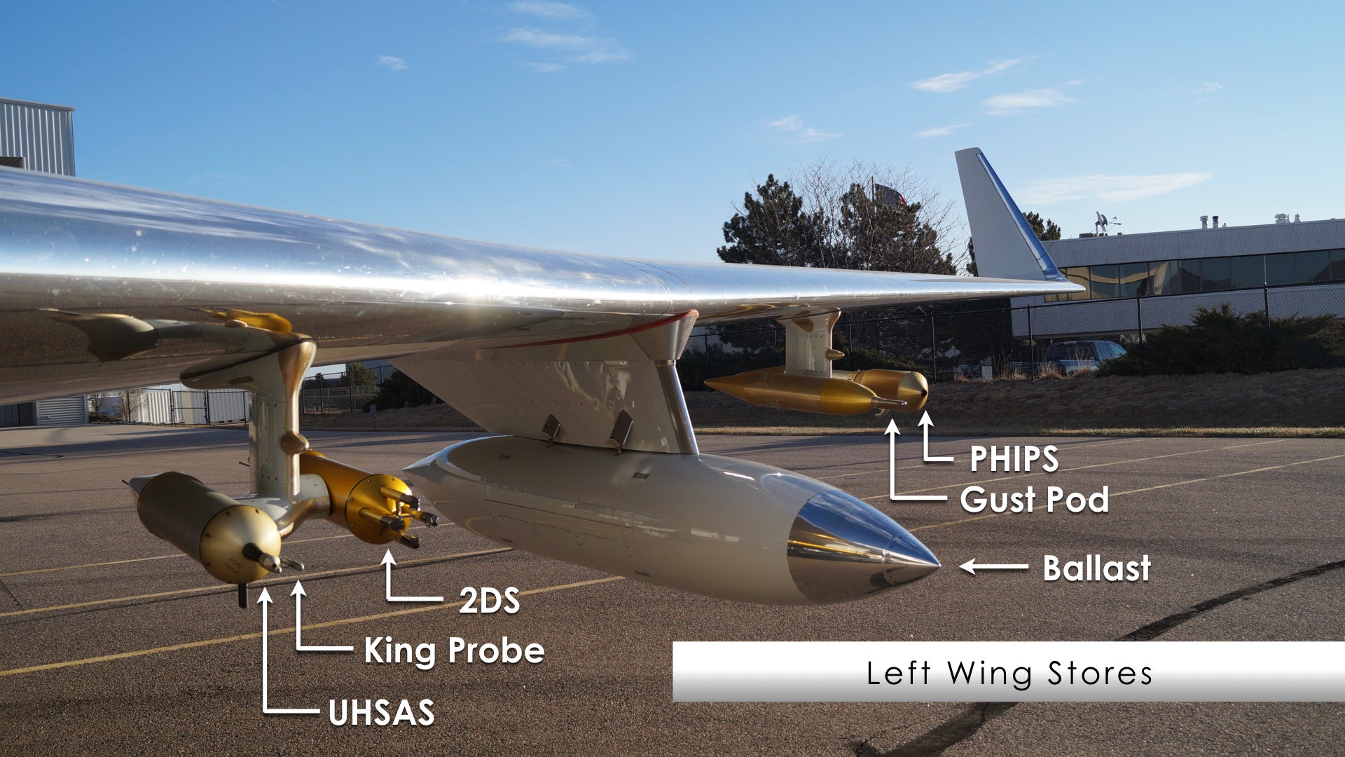
Left Wing Stores
| Instrument Acronym |
Instrument Name |
Measurement |
| 2DS | Two-Dimensional Stereo probe | Two-dimensional images of cloud and precipitation particles from 10-1280 µm |
| Ballast | -- | A non-operational pod that mirrors the weight and aerodynamics properties of the opposite side wing store |
| Gust Pod | All Weather Wind Gust Pod | 3-D wind in all conditions and provides aircraft position, attitude, ground speed, aircraft attack angle (AKRD), Solid State Recording Device (SSRD), and aircraft true air speed (TASX) |
| King Probe | King (CSIRO) Liquid Water Sensor | Cloud liquid water content |
| PHIPS | Particle Habit Imager and Polar Nephelometer | Simultaneously images a cloud particle and measures its angular scattering phase function |
| UHSAS | Ultra-High Sensitivity Aerosol Spectrometer | Concentration and size distribution of aerosol particles having diameters from 0.060 --1.0 µm |
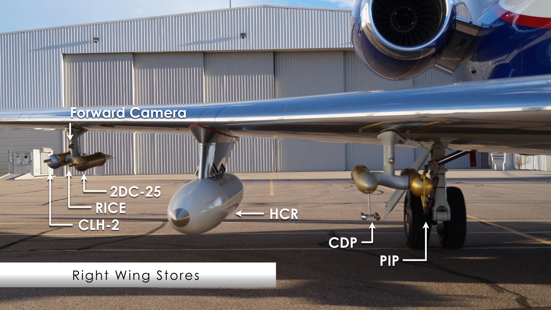
Right Wing Stores
| Instrument Acronym |
Instrument Name |
Measurement |
| 2DC-25 | Two-Dimensional Optical Array Cloud Probe | Two-dimensional images of hydrometeors from 25-1560 µm |
| CDP | Cloud Droplet Probe | Cloud droplet size distribution and various measurements derived from that size distribution from 1-50 µm |
| CLH-2 | University of Colorado Closed-path Laser Hygrometer, v2 | “Total water”, the sum of water vapor and particulate water, water vapor resulting from the evaporation of cloud particles |
| Forward Camera | Forward Camera | Provides imagery of the scene ahead of aircraft. Image resolution is 1024x768, with a 62° (horizontal) x 48° (vertical) field of view |
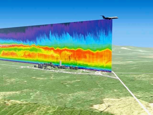
| HCR | HIAPER Cloud Radar | Radar W-band reflectivity factor and radial velocity of hydrometeors |
| PIP | Precipitation Imaging Probe | Quantity and images of precipitation sized particles from 100 microns to 6.4 mm in size |
| RICE | Rosemount Icing Detector | Presence of supercooled water; also a rough measurement of the quantity |
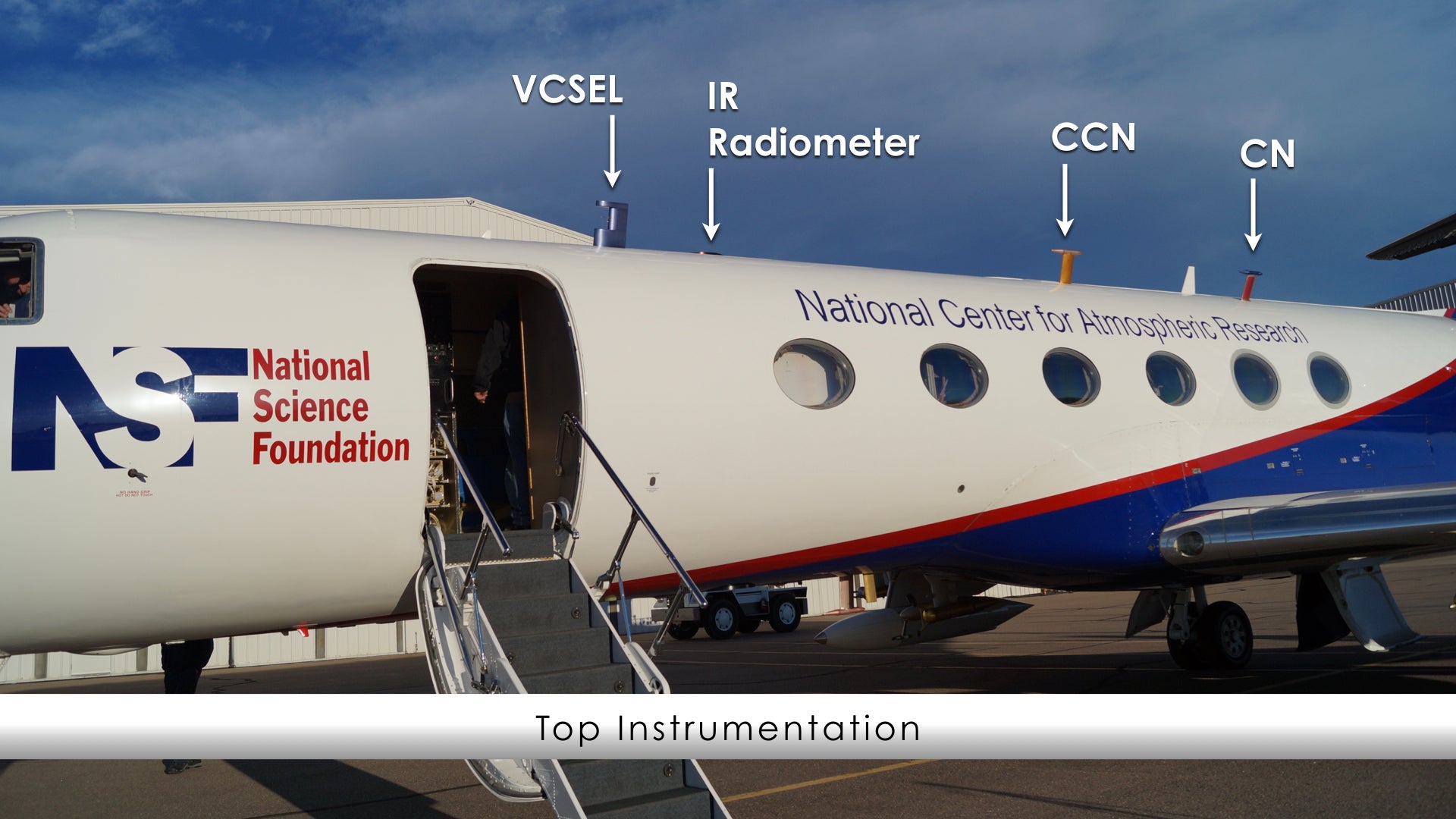
Top Instrumentation
| Instrument Acronym |
Instrument Name |
Measurement |
| CCN | Cloud Condensation Nuclei Counter | Spectrum of cloud condensation nuclei concentration |
| CN | Condensation Nucleus Counter | Total ambient concentration of aerosol particles larger than the threshold size for the instrument, typically about 11 nm diameter (6 nm for the water-based counter); dependent on flight conditions |
| IR radiometer | Infrared radiometer | Infrared radiation |
| VCSEL | Vertical Cavity Surface-Emitting Laser Hygrometer | Water vapor concentration and related derived values (mixing ratio, dew point, etc.) |
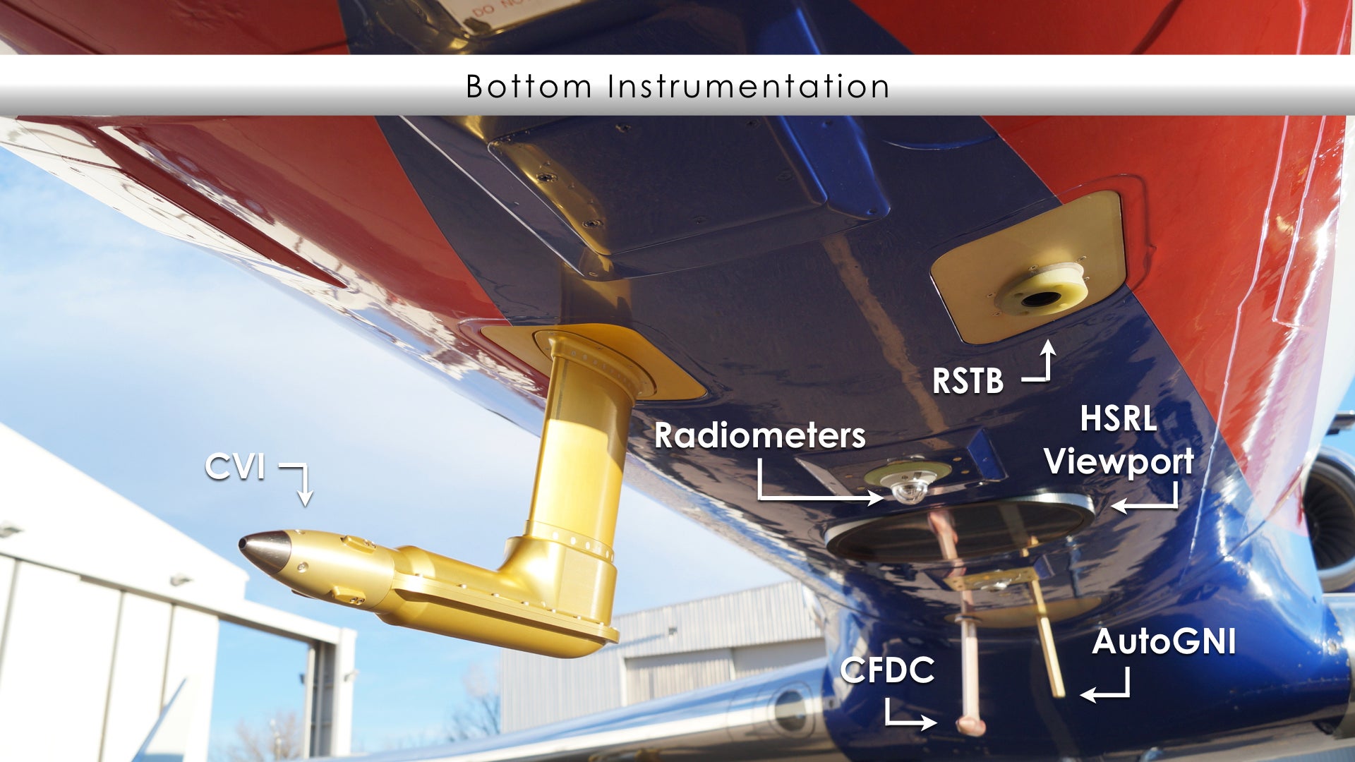
Bottom Instrumentation
| Instrument Acronym |
Instrument Name |
Measurement |
| CFDC | Continuous Flow Diffusion Chambers | Particle size distribution |
| CVI | Counterflow Virtual Impactor | Cloud particle concentration, condensate mass, water vapor (for isotopic analysis) and aerosol particle residuals |
| AutoGNI | Giant Nuclei Impactor | Giant aerosol particles |
| HSRL (Viewport) | High Spectral Resolution Lidar | Back scatter cross section, extinction and depolarization properties of atmospheric aerosols and clouds |
| Radiometers | Broadband Radiometers | Infrared (IR) and Visiible spectrum |
| RSTB | Radiometric Surface Temperature | Terrestrial radiation |


SOCRATES Educational Resources
| VIDEOS |
|
Air. Planet. People. |
NSF/NCAR HIAPER Research Aircraft
|
|
|
From Measurements to Models
|
Science Nation :: Dropsondes |
|
|
Principles of Instrumentation and Measurement |
Engineering for Scientific Discovery |
| K-12 SCIENCE EDUCATION MODULES |
 Earth's atmosphere is a mixture of gases that surrounds our home planet. Besides providing us with something to breathe, the atmosphere helps make life on Earth possible in several ways. It shields us from most of the harmful ultraviolet (UV) radiation coming from the Sun, warms the surface of our planet by about 33° C (59° F) via the greenhouse effect, and largely prevents extreme differences between daytime and nighttime temperatures.
» Learn more
Exploring the Atmosphere with Dropsondes
 Let’s say you would like to know how temperature, wind, air pressure and humidity vary throughout a hurricane. This information could help you know whether the hurricane is growing stronger and which direction it is heading. But hurricanes are dangerous storms. It's hard to get inside them. One way to get that information safely is to use dropsondes.
» Learn more
Exploring the Atmosphere with Weather Balloons
 Every 12 hours, hundreds of people in places around the world release huge, white balloons into the sky. The balloons float upward, each tethered to a box of instruments that collects data about the atmosphere.
» Learn more
| ADVANCED SCIENCE EDUCATION MODULES |
Introduction to Climate Models (free login required)
 This module explains how climate models work. Because the modeling of both weather and climate share many similarities, the content throughout this module draws frequent comparisons and highlights the differences. We explain not only how, but why climate models differ from weather models.
» Learn more
How Models Produce Precipitation and Clouds - version 2 (free login required)
 This module, part of the "NWP Training Series: Effective Use of NWP in the Forecast Process", explores how NWP models handle both grid-scale microphysical (precipitation) and convective processes through parameterizations and/or explicit methods, with an emphasis on how model treatment (and errors in the triggering) of these processes affects forecast depiction of precipitation and related forecast variables.
» Learn more
Introduction to Tropical Meteorology (free login required)
 This online textbook is a comprehensive resource for Tropical Meteorology. It is intended for use by undergraduate and early graduate students in Tropical Meteorology courses, forecasters, and others interested in the impacts of tropical weather and climate.
» Learn more


SOCRATES in the News
Four New DOE Early Career Research Program Award Winners Plan to Use ARM Measurements
25 July 2018 | ARM
 In late June, 84 scientists around the country received Early Career Research Program awards from the U.S. Department of Energy (DOE). The 54 awardees from universities will receive at least $150,000 a year for five years to further their research. The 30 recipients from national labs will receive at least $500,000 annually. Four of the young scientists will use measurements from DOE’s Atmospheric Radiation Measurement (ARM) user facility.
» Read more
Researchers fly and sail to stormiest place on Earth to study cloud processes
12 April 2018 | Colorado State University
 By ship and by plane, Department of Atmospheric Science researchers ventured to the stormiest place on Earth, the Southern Ocean, to collect cloud, aerosol and precipitation data for a project called SOCRATES. Knowledge gained during the Southern Ocean Clouds, Radiation, Aerosol Transport Experimental Study is expected to enhance weather and climate modeling and forecasting capabilities across the globe.
» Read more
Mysteries of Southern Ocean air on the radar of landmark atmospheric study
11 February 2018 | ABC News Australia
 A crack team of US climate researchers have gathered in Hobart to unlock the mysteries of the air above the Southern Ocean. To help them, they have control of a state-of-the-art Gulfstream V aircraft, packed full of cutting-edge climate reading machines and instruments.
» Read more
UW atmospheric scientists flying through clouds above Antarctica’s Southern Ocean
5 February 2018 | UWNEWS
 University of Washington scientists are part of an international team that is spending six weeks in the remote Southern Ocean to tackle one of the region’s many mysteries: its clouds. What they discover will be used to improve climate models, which routinely underestimate how much solar energy bounces off clouds in that region. Simulating how much solar energy is absorbed or reflected on Earth is key to calculating the future of the planet under climate change.
» Read more
SOCRATES meets ZephIR as Lidar project sets sail to inform global warming strategy
16 January 2018 | ZephIR Lidar
 This month, an international team of scientists will head to the remote Southern Ocean with a ZephIR 300 wind lidar providing the project’s remote wind measurements on-board the R/V Investigator, an Australian deep-ocean research vessel. The U.S. portion of the project is funded by the National Science Foundation (NSF).
» Read more
A 'Super-cooled' weather mystery in the Southern Ocean
11 January 2018 | NBC 9 News
 There is a weather mystery near the Southern Ocean at the bottom of our planet, and a group of Boulder scientists are preparing to go there to solve what they call a “supercooled” mystery. The mystery is actually in our climate models and the clues are in the clouds.
» Read more
The Climate Secrets of Southern Clouds
9 January 2018 | AtmosNews
 This month, an international team of scientists will head to the remote Southern Ocean for six weeks to tackle one of the region's many persistent mysteries: its clouds. What they discover will be used to improve climate models, which routinely underestimate the amount of solar radiation reflected back into space by clouds in the region.
» Read more
Deep diving for answers on climate
9 January 2018 | CSIRO
 A global network of over 3800 Argo floats already provide us with an understanding of ocean temperature and salinity up to 2000 metres, however these new generation, data-collecting, autonomous ocean robots will provide unprecedented information about oceans up to depths of 5000 metres.
» Read more
Searching for super-cooled Southern Ocean clouds
29 October 2017 | Australian Antarctic Division
 Atmospheric scientists will use ships, aircraft and satellites to study super-cooled Southern Ocean clouds this summer. The project involving Australian and United States researchers will gather data on super-cooled cloud formations, which are clouds that remain as liquid water well below freezing.
» Read more


SOCRATES Media Kit
SOCRATES is an atmospheric science research project studying cloud-aerosol interactions for liquid and ice clouds, and the role of primary and secondary marine biogenic aerosols and sea-salt. SOCRATES is funded by the National Science Foundation (NSF) with operational support from EOL. The project is led by Principal Investigators from the University of Illinois and the University of Washington, both U.S. universities. SOCRATES aircraft operations will be based in Hobart, Tasmania, and the NCAR Integrated Sounding System being operated on board the R/V Investigator from January - February 2018.
All images must be credited to UCAR/NCAR and may be reproduced in news stories about UCAR & NCAR activities. High-resolution video is available; please send a request to Alison Rockwell.
| IMAGES |
» Click on image to download high-resolution copy. News media terms of use*.
NSF/NCAR HIAPER Research Aircraft
The NSF/NCAR High-performance Instrumented Airborne Platform for Environmental Research (HIAPER) aircraft is a cutting-edge observational platform that will meet the scientific needs of researchers who study many different areas: Chemistry and Climate, Chemical Cycles, Studies of the Upper Troposphere/Lower Stratosphere, Air Quality, and Mesoscale Weather.
To properly cite the aircraft, use the following text: the NSF/NCAR HIAPER Gulfstream V research aircraft
|
© Photo by NSF |
© Photo by NCAR |
|
NCAR Integrated Sounding System (ISS)
For this project, the ISS will be located on the R/V Investigator. The Integrated Sounding Systems (ISS) is a self contained meteorological observing system at the Earth Observing Laboratory of the National Center for Atmospheric Research. The ISS combines surface, sounding, and remote sensing instrumentation to provide a comprehensive description of lower atmospheric thermodynamics and winds.
|
© Photo by NCAR/EOL |
© Photo by NCAR/EOL |
© Photo by NCAR/EOL |

NCAR AVAPSTM (Airborne Vertical Atmospheric Profiling System)
The AVAPS Dropsonde System is a key atmospheric instrument that measures high resolution vertical profiles of ambient temperature, pressure, humidity, wind speed and wind direction. Measurements are taken by a parachuted GPS dropsonde that is launched from the aircraft and descend to the surface. In-situ data collected from the sonde’s sensors are transmitted back in real time to an onboard aircraft data system via radio link.
|
© Photo by NCAR/EOL |
© Photo by NCAR/EOL |
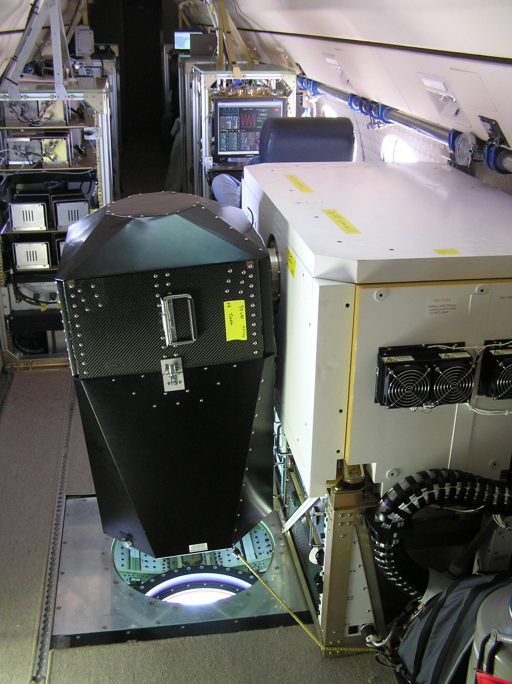
NCAR HIAPER Cloud Radar (HCR)
The HIAPER cloud radar (HCR) is an airborne, polarimetric, millimeter-wavelength radar that will serve the atmospheric science community by providing cloud remote sensing capabilities to the NSF/NCAR HIAPER GV aircraft.
|
© Photo by NCAR/EOL |
© Photo by NCAR/EOL |
© Photo by NCAR/EOL |
NCAR High Spectral Resolution Lidar (HSRL)
The NCAR High Spectral Resolution Lidar (HSRL) is an eye-safe calibrated lidar system that measures back scatter cross section, extinction and depolarization properties of atmospheric aerosols and clouds. The instrument can also be used to detect the presence of oriented scatters in the atmosphere and determine the full (Mueller) backscatter phase matrix.
|
© Photo by UCAR COMET |
© Photo by NCAR/EOL |
| VIDEOS |
External Shots of the NSF/NCAR HIAPER research aircraft
![]() The NSF/NCAR HIAPER research aircraft leaves NCAR's Research Aviation Facility in Boulder, Colorado; takes off against Denver skyline. Landing in Anchorage; tow to hangar. Research prepares dry ice for use chilling onboard instruments. Technicians check instrument pods on wings. Technician explains Data Sampling Module, one of seven minicomputers used to send signals from wing-mounted sensors to monitors on board. HIAPER positioned for takeoff and taxiing on Anchorage runway, mountains in background. (©UCAR. QuickTime, 4:29)
The NSF/NCAR HIAPER research aircraft leaves NCAR's Research Aviation Facility in Boulder, Colorado; takes off against Denver skyline. Landing in Anchorage; tow to hangar. Research prepares dry ice for use chilling onboard instruments. Technicians check instrument pods on wings. Technician explains Data Sampling Module, one of seven minicomputers used to send signals from wing-mounted sensors to monitors on board. HIAPER positioned for takeoff and taxiing on Anchorage runway, mountains in background. (©UCAR. QuickTime, 4:29)
Media Terms of Use
*Media & nonprofit use of images: Except where otherwise indicated, media and nonprofit use permitted with credit as indicated above and compliance with UCAR's terms of use. Find more images in the UCAR Digital Image Library.
The University Corporation for Atmospheric Research manages the National Center for Atmospheric Research under sponsorship by the National Science Foundation. Any opinions, findings and conclusions, or recommendations expressed in this publication are those of the author(s) and do not necessarily reflect the views of the National Science Foundation.