Search
Educational Resources
RETI 2011 : Climate Science Classroom Activity
Several climate science lesson plans were developed by science teachers involved with the Research Experience Teachers Institute (RETI) program, sponsored by University of Northern Colorado and NCAR.
The HIPPO project was used as one base example of real climate science being conducted. Teachers incorporated the HIPPO project into their curriculum as a means for students to gain a better understanding of the scientific process, current research in climate science, and to connect the students with scientists in the field.
Explore the RETI 2011 climate science curriculum projects.
AGU Geophysical Information for Teachers (GIFT) Workshop 2011

Using Scientific Field Campaigns to Learn About Climate Science
Presented by Alison Rockwell, Vidal Salazar, Becca Hatheway, and Sarah Bruemmer
This workshop provided information about how scientists use large scale field campaigns to collect data about the Earth's atmosphere in order to learn more about climate science. The hands-on activities allow teachers and students to analyze climate data sets and gain a better understanding of how climate models work.
Presentation:
Classroom Activities:
Twenty Questions and Answers About the Ozone Layer : 2010 Update
 Ozone QA Download NOAA Earth System Research Laboratory's Twenty Questions and Answers About the Ozone Layer, it's a fabulous addition to any Earth science curriculum.


HIPPO II - Christchurch, New Zealand
November 11, 2009
The NSF/NCAR HIAPER Gulfstream V (GV) and the HIPPO project were enthusiastically welcomed to Christchurch, New Zealand by the media and by many related organizations, including the National Institute for Water and Atmospheric Research (NIWA), the University of Canterbury, NSF local representatives and the International Antarctic Center.
 Almost half of the attendees were students from the university's Chemistry and Physics Departments from the University of Canterbury. Additional help from the NIWA Media Advisor was greatly appreciated and brought in many people associated with NIWA, as well as local news and radio stations, and newspapers. The event flier was also sent out to about a dozen local secondary schools, however due to the timing of school vacations, many groups were unable to attend. Visitors from the International Antarctic Center rounded out the guest list.
The media was particularly excited to cover this event due to the fact that the during the inbound flight to Christchurch, HIAPER did a fly-over of NIWA’s Lauder observatory to compare baloon versus airborne measurements. New Zealand's Scoop posted a media statement by NIWA called Is it a bird? a plane? No, it’s a low flying hippo , that did a superb job explaining the science behind HIPPO and how it is supporting related research by NIWA. Other media coverage included New Zealand's Channel 3 (TV3) that put together a fantastic clip called Scientists in Christchurch to sample our atmosphere and aired on their nightly news. TVNZ played a wonderful clip titled US research plane measures gas over Otago. Additionally, the NZ Herald posted an article US jet tests gas levels in sweep of NZ atmosphere that clearly outlines the atmospheric science research that the GV is conducting.
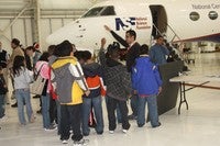
The NSF/NCAR GV was open to the public on Wednesday, November 11, as well as the before mentioned institutions, and we had about 40 visitors, including 15 university students. The NSF/NCAR GV crew, plus a few EOL staff, who flew to New Zealand to assist with ground operations, assisted with the event. The visitors were able to talk one-on-one with the scientists and project coordinators, as well as get on board the NSF/NCAR GV and see the sampling instruments first-hand and learn more about the important science that EOL is supporting.
The HIPPO Outreach Event in Christchurch had a great turnout and received positive feedback from all who were involved. Providing this event for the local community proved to be a wonderful experiential learning opportunity for students and other interested parties to learn more about atmospheric science and aviation research. Thank you to all who participated in this fantastic event!


HIPPO II - Anchorage, AK
November 3, 2009: 2pm-4pm
 A group of eight students and a professor from Alaska Pacific University’s Environmental Studies program, a news crew from the local NBC station and an independent writer joined the HIPPO outreach event in Anchorage, Alaska. The smaller, more intimate setting allowed for everyone to fully engage in this wonderful learning opportunity and talk one-on-one with the research scientists, project coordinators and the flight crew. NCAR/EOL invited students from many school groups and organizations, however with the delays in HIPPO project and date change of the outreach event made it difficult for all of those who wanted to attend. The attendees were given the opportunity to climb onboard the NSF/NCAR GV and to ask questions about aviation research, instruments and the science EOL is supporting.
 The local Anchorage NBC news station, Channel two KTTU, covered the event and posted a news story, Plane Sampling Atmosphere Lands in Anchorage After Arctic Flight, which reports on the research that HIPPO is conducting. They also had a brief piece on the HIPPO project on their Tuesday, November 3, 2009 6:00 Evening News broadcast.
Visitors were encouraged to follow the HIPPO project by going to the website as well as following the research project on Facebook.
 The HIPPO Outreach Event in Anchorage had a fewer than expected visitors, however the target audience of the HIPPO project, university level students, was definitely met. We will continue to seek more opportunities to engage university level students in the EOL Field Project Services missions. Providing this event for the local community proved to be a wonderful experiential learning opportunity for students to learn more about atmospheric science and aviation research. Thank you to all who participated in this fantastic event!
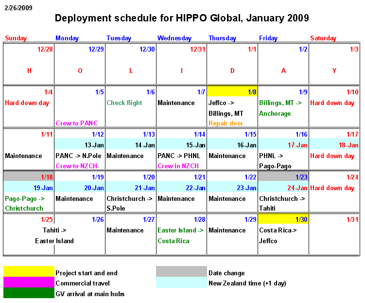
Mission Schedule
This schedule reflects changes that were necessitated by the replacement of the damaged pressure seal on the baggage door of the GV (1/7/2009) and by repairs to the main cabin door latch (1/8/2009). Currently, the entire schedule is shifted back by two days.
Please refer to the Work Schedule for more details. The schedule below is a general plan, and daily changes may occur that are not reflected in the table below. They will eventually make it into the schedule but the table is harder to keep current, so the last minute changes are here.