IOP 6: 04-05 December 2001
Time Period of IOP
1630 UTC 4 Dec-0600 UTC 5 Dec
Overview of IOP
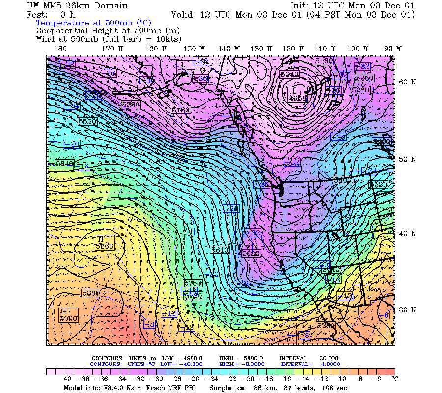
The fifth and sixth short waves in this multi-day sequence moved in rapidly from the west northwest on 3-4 December 2001. At 500 mb the first short wave trough was evident at 1200 UTC 3 December at about 145 oW (Fig. 1a). By 0000 UTC 4 December, this trough was at about 132 oW (Fig. 1b), and it was centered over the Washington and Oregon Cascades at 1200 UTC 4 December (Fig. 1c). The infrared satellite imagery shows a quasi-frontal cloud system associated with the first short wave trough moving into the S-Pol radar area in Oregon at 2300 UTC 3 December 2001 (Fig. 2a). At 0500 UTC 4 December the cloud area of the short wave was centered over the radar area, with one major component still northwest of the radar, and another band of enhanced brightness east of the radar (Fig. 2b). By 1100 UTC, the quasi-frontal cloud band had moved east of the radar, and postfrontal convective clouds were located in the western part of the radar area (Fig. 2c). By 1700 UTC , the enhanced cloud pattern of the second short wave trough was moving over the radar and had the appearance of a jet streak cloud system (Fig. 2d). This feature strengthened and moved in and became centered over the southern portion of radar area (Fig. 2e). The S-Pol low-level PPI scans were picking up echoes of precipitation moving into the area at 0500 UTC 4 December (Fig. 3a). At 0800 UTC a solid frontal-like band of precipitation about 80 km in width was centered over the radar (Fig. 3b). By 1100 UTC this main band of echo had moved over the mountains to the east, and the echoes in the vicinity of the radar had begun to look more postfrontal in character (Fig. 3c). Cellular echoes were still present at 1400 UTC but were smaller and weaker (Fig. 3d).
The P-3 and Convair flew in the second short wave, as it continued to intensify over the radar area. At 0000 UTC 5 December the enhanced infrared cloud top image was covering the southwestern quadrant of the S-Pol radar area, and the cloud area was being cut off abruptly on its eastern edge, apparently, by orographically induced downward motion (Fig. 4a). The P-3 entered the radar area at about 2300 UTC 4 December and was starting its dual-Doppler pattern at 0000 UTC 5 December (Fig. 5a). At 0300 UTC the satellite infrared enhance cloud top formed a frontal-like band oriented SW-NE and centered over the S-Pol radar (Fig. 4b). At this time the P-3 was flying a microphysical sampling pattern on an east-west track across the mountains east of the S-Pol radar (Fig. 5b). The Convair flew a vertical profile from 16,000 to 13,000 ft above the P-3 on west-east track over Santiam Pass. The ETL S-band profiler showed that the precipitation at this time was highly convective, with updrafts appearing at about 1.5 km AGL (Fig. 6).
Convair-580 Summary
UW Flight Number:
1895
Period of Flight:
2247 UTC 4 December-0151 UTC 5 December 2001
Main Accomplishment of Flight:
Vertical profile from 16,000 to 13,000 ft on west-east track over Santiam Pass. (P-3 flew below Convair-580.) Landed in Eugene.
Instrument Problems:
Possible problems with PMS 1-D cloud probe
Flight Scientist:
Peter V. Hobbs
Approximate UTC Timeline (Local time= UTC-8 hours) Activity for UW Flight 1895:
2257 |
Takeoff. |
2257-~0001 (12/5) |
Transit to start point. |
~0001-0023 |
West à east, 16,000 ft. |
~0023 à |
0050 East à west desc. to 14,500 ft. |
0050 à 0115 |
(waiting for clearance) West à east at 14,5000 ft. |
~0118 à ~0125 |
East à west desc. to 13,000 ft. |
~0125 |
Broke off at ~0125 UTC on west bound leg due to pilot's airspeed indicator going out. Measurements on descent into Eugene. |
0151 |
Engines off. |
P-3 Summary
P-3 Flight Number:
011204H, IMPROVE 03
Period of Flight:
2227 UTC 4 December-0327 UTC 5 December 2001
Main Accomplishment of Flight:
The P-3 took dual-Doppler and microphysical data in conjunction with the flight of the Convair.
Instrument Problems:
-
Flight Scientist:
Nick Bond
Approximate UTC Timeline (Local time= UTC-8 hours) Activity for P-3 Flight 03:
2:27pm Engine Start
2:32pm Block Out
2:39 pm Takeoff
Actual takeoff
entered cloud base
224526 UTC (47.72373, -122.51717) 230.612°, 781.3 mb, 2035.0 m wind 250o at 15 kts
224807 UTC (47.60429, -122.62686) 192.210°, 718.2 mb, 2596.0 m tail radar up 5 minutes ago.
225854 UTC (46.91788, -122.93411) 185.375°, 569.8 mb, 4345.0 m radar down. Convective tops around aircraft to 4.5 km.
230331 UTC (46.59182, -123.05453) 196. 23 cloud station up and working.
230640 UTC (46.36724, -123.11476) 175.418°, 571.0 mb, 4140.0 m radar back up 5 minutes ago.
231136 UTC (45.99902, -123.06897) 172.824°, 572.2 mb, 4064.0 m radar down. Within widespread echo at mid-levels. Radar was filling in before it went down. Temp -25.2 oC
231741 UTC (45.57755, -123.00696) 175.738°, 572.0 mb, 4368.0 m all radars up again. Within widespread/uniform ice cloud from 5 km to surface. Echoes surprisingly uniform even if with steep lapse rates.
231904 UTC (45.48827, -123.02010) 189.826°, 594.5 mb, 4087.0 m started decent to 6 k ft one minute ago.
232448 UTC (45.11684, -123.04106) 178.609°, 810.6 mb, 1759.0 m at 6 kt feet. Widespread echo around the aircraft to 75 km. Echoes light < 25 dBZ
232735 UTC (44.94235, -123.03590) just south of point A. To 25 dBZ over foothills 20 km west of aircraft. Nice gradual sloping echo field over foothills. 4.5 km deep. Temp -5.5 oC, winds 250o at 37 kts.
234707 UTC (43.76271, -123.02628) 162.932°, 797.9 mb, 1619.0 m At point F, starting climb to 8kt. Radar echo was weakening as we approached point F. Just light echo to15 dBZ within 20 km of aircraft.
235138 UTC (43.73425, -122.61497) 56.622°, 753.0 mb, 1457.0 m At point G, starting northbound leg at 8kt ft. Temp -8C, winds 242/38kts. Echoes below aircraft to 24 dBZ.
000510 UTC (44.68037, -122.56819) 359.471°, 752.7 mb, 1741.0 m Stratiform precip has filled in more around aircraft. Getting great doppler coverage and microphysics at -9 oC, winds 244/31kts.
000955 UTC (45.01089, -122.56090) 9.463°, 743.5 mb, 2009.0 m At point B, starting climb to 11 kft. Got some nice dendrites around –10 oC.
001155 UTC (45.12153, -122.43289) 70.908°, 669.9 mb, 2837.0 m reached 11 kft. Winds 255o/43kts, temp-15.7 oC, dewpoint-16.7 oC.
001425 UTC (45.10608, -122.16867) 136.625°, 669.8 mb, 2585.0 m stratiform precip to 24 dBZ. Some evidence of a secondary bright band around 2.5 km, probably within max dendrite growth region.
001630 UTC (44.97415, -122.10022) 176.733°, 669.9 mb, 2680.0 m reached point C a couple minutes ago. Winds 250o/42kts. temp-17 oC
002758 UTC (44.22675, -122.08504) 179.899°, 669.9 mb, 2282.0 m temps have gradually increased to -15.2 oC. winds 257o/42kts. Right at top of enhanced precip to 22 dBZ.
003435 UTC (43.78763, -122.08191) 164.033°, 666.3 mb, 1788.0 m At point H, climbing to 13 kft. Still in widespread precip. Did not notice any distinct precip enhancements over individual peaks during past leg. At 13kt temp=-19 oC, 283o/43kts.
003906 UTC (43.74596, -121.63779) 14.105°, 618.3 mb, 2583.0 m At point G at 13kft. Winds 270o/41kts. Precip covereage drops off significantly 15 km to the west of plane.
005110 UTC (44.59812, -121.61647) 359.603°, 617.8 mb, 2882.0 m radar down.
005151 UTC (44.64896, -121.61702) 359.558°, 617.9 mb, 2952.0 m radar quickly back up. Echoes only to the left of plane. Some evidence of sloping echo along the lee slope. Temp -19.5 oC, wind 270o/43kts
005700 UTC (45.022011447 UTC (44.53233, -121.59709) at point D, descending back down to 10kt. Encountered some lee wave turbulence just before point D.
010607 UTC (44.75910, -121.13535) 180.062°, 693.3 mb, 2301.0 m no much precip arround plane. Just to 5 DBUTC.
010857 UTC (44.57002, -121.13284) 189.086°, 692.4 mb, 2176.0 m Breaking southbound leg at lat of point Q. To start west leg at 13 kft. Very little echo here.
011024 UTC (44.53767, -121.23328) 270.525°, 642.2 mb, 2788.0 m reached 13kft. Temp -17.7 oC, winds 270o/40kts.
011512 UTC (44.53263, -121.63080) 271.160°, radar down for a couple minutes. Nice wave length structure in vertical velocity and a few good bumps.
011913 UTC (44.53313, -121.95842) 269.604°, 642.0 mb, 2321.0 m more widespread precip and dendrites. Started descent at 0121 UTC.
012522 UTC (44.53279, -122.46231) 269.800°, 752.2 mb, 1842.0 m ambient temperature about –9 oC; with large rimed dendrites and what appears to be some liquid water in cloud.
013023 UTC (44.52911, -122.87538) 268.495°, 752.3 mb, 2036.0 m Convair headed home about 1:20 UTC (lost air speed indicator).
013241 UTC (44.52745, -123.06622) 271.598°, 750.7 mb, 2317.0 m started climb and turn; uniform precip to west before we initiated turn.
014011 UTC (44.46234, -122.61966) 237.720°, 645.4 mb, 2943.0 m Very obvious secondary bright band extending across tail radar display; well below level of aircraft
014430 UTC (44.40684, -122.90321) 32.776°, 645.7 mb, 3296.0 m about over point M. Will hold 12k ft until point 0. -16.5 oC ambient. rimed dendrites.
015501 UTC (44.43151, -121.71146) 90.902°, 643.4 mb, 2572.0 m Wind holding right near 50 kt. Precip very steady state with little horizontal variation.
020030 UTC (44.39371, -121.61902) 282.060°, 644.9 mb, 1948.0 m Started descent to 10k ft. Very close to crest of Cascades - westbound.
020344 UTC (44.38945, -121.87445) 267.629°, 694.7 mb, 1544.0 m 10k ft ambient temp -13.5 oC; plenty of dendrites.
021522 UTC (44.37776, -122.82436) 270.147°, 694.6 mb, 2747.0 m Very near point M. 10K ft ambient temp as warmed to about -12.5C. Wind 256o at 35kt.
021825 UTC (44.37933, -123.07571) 277.089°, 693.7 mb, 2922.0 m End of leg west bound beginning climb....up up and away. Heading home....a keeper!
025838 UTC (47.32586, -122.73151) 8.994°, 808.0 mb, 1747.0 m radar taken down.
032237 UTC (47.90707, -122.28560) 178.341°, 985.6 mb, 9.0 m landed.
032705 UTC (47.90024, -122.28056) 176.644°, 985.6 mb, 6920.0 m Engine off and block in
S-Pol Radar Summary
The S-Pol radar was run continuously in the same mode of operation for the length of the field project.
Summary of Mobile Upstream Sonde Launches
Launch times at: Rowland, OR, Lat: 44.2800, Lon: -123.0650, Elev: 97 m
1630 UTC 4 Dec
2059 UTC 4 Dec
0131 UTC 5 Dec
0327 UTC 5 Dec
Summary of Leeside Sonde Launches
Launch times at: Black Butte Ranch, OR (a.k.a. ISS-3), Lat: 44.379, Lon: -121.679, Elev: 1027 m
2255 UTC 4 Dec
0055 UTC 5 Dec
0250 UTC 5 Dec
0450 UTC 5 Dec
Summary of NWS Sonde Launches from Salem (SLE)
Launch times:
0000 UTC 5 Dec (standard)
0300 UTC 5 Dec (special)
0600 UTC 5 Dec (special)
Summary of Snow Crystal Ground Measurements
Measurement times:Every 15 minutes from
2145 UTC 4 Dec-0300 UTC 5 Dec (at Santiam Pass, Corbett, and Tombstone Sno Park)


