IOP 4:
Time Period of IOP
1200 UTC 1 Dec-0000 UTC 2 Dec
Overview of IOP
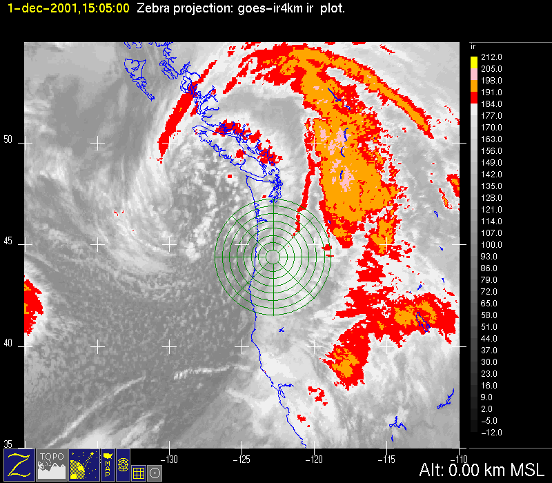
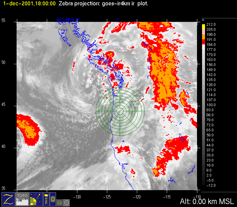
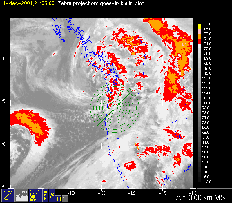
Postfrontal conditions prevailed following the third short wave trough (described above). The satellite infrared sequence shows the convective cloudiness passing over the radar area (Fig. 1a, Fig. 1b, Fig. 1c). The P-3 aircraft flew a mission this day. When the aircraft arrived in the S-Pol radar area from 1500-1600 UTC 1 December 2001, the back portion of the frontal precipitation was over the mountains to the east (Fig. 2a, Fig. 2b). The ETL S-band profiler showed convective cells (as described above (Fig. 3). For about two hours (~1600-1800 UTC) the aircraft executed a dual-Doppler radar pattern in the moderately intense postfrontal precipitation over the mountains east of the S-Pol radar (Fig. 2c, Fig. 2d). At 1907 UTC the S-Pol particle identification algorithm indicated graupel at or just above the melting level over an extensive region (Fig. 4). From ~1900-2100 UTC the aircraft executed a microphysical sampling pattern (Fig. 2e, Fig. 2f, Fig. 2g, Fig. 2h). The P-3 left the study region at about 2100 UTC.
Convair-580 Summary
UW Flight Number:
1894
Period of Flight:
1456-1656 UTC,
Main Accomplishment of Flight:
Convair-580 returned to Paine Field just after crossing the
Instrument Problems:
-
Flight Scientist:
Peter V. Hobbs
Approximate UTC Timeline (Local time= UTC-8 hours) Activity for UW Flight 1894:
1508 |
Takeoff. |
1508-~1610 |
Transit to south of |
~1610-1656 |
Return to Paine Field. |
P-3 Summary
P-3 Flight Number:
011201H, Improve 02
Period of Flight:
1456 UTC 1 December-? UTC
Main Accomplishment of Flight:
The P-3 took dual-Doppler measurements in intense postfrontal precipitation.
Instrument Problems:
-
Flight Scientist:
Nick Bond
Approximate UTC Timeline (Local time= UTC-8 hours) Activity for P-3 Flight 02:
Engine Start
Block Out
Takeoff
145652 UTC (47.91171, -122.28354) 7.621°, 965.3 mb, 1255.0 m taxiing
rain before takeoff
150438 UTC (47.87386, -122.31438) 237.682°, 923.3 mb, 402.0 m takeoff
150729 UTC (47.79729, -122.49591) 225.594°, 812.3 mb, 1568.0 m in mod snow
151348 UTC (47.48796, -122.65120) 199.355°, 609.9 mb, 3709.0 m in clear air ci above
152455 UTC (46.82231, -122.96526) 194.306°, 553.2 mb, 4461.0 m in higher cloud layer
152834 UTC (46.61064, -123.03784) 192.813°, 553.6 mb, 4391.0 m in clear air again
152931 UTC (46.55721, -123.05576) 192.804°, 553.6 mb, 4107.0 m back in cloud
154012 UTC (45.90298, -123.03680) 174.783°, 558.6 mb, 4013.0 m in clear after light jolt in and out of clouds
154645 UTC (45.47778, -122.97495) 139.437°, 575.8 mb, 4208.0 m descending into clouds
155657 UTC (45.15850, -123.00327) 185.158°, 794.1 mb, 1745.0 m tail radar indicates good convection to west
171047 UTC (43.77438, -121.83636) 94.728°, 607.6 mb, 2571.0 m broke out on top - sunshine!
181936 UTC (44.14136, -122.50940) 61.082°, 538.1 mb, 4178.0 m in cloud..
62) 242.829°, 557.1 mb, 3875.0 m broken layer below, scattered clouds at flight level
205749 UTC (45.97282, -123.09065) 355.921°, 466.3 mb, 5413.0 m NW of Portland at 20K, between layers
S-Pol Radar Summary
Summary of Mobile Upstream Sonde Launches
Launch times at: Creswell, OR, Lat: 43.9200, Lon: -123.0250, Elev: 165 m
1700 UTC 1 Dec
1913 UTC 1 Dec
2229 UTC 1 Dec
Summary of Leeside Sonde Launches
Launch times at: Black Butte Ranch, OR (a.k.a. ISS-3), Lat: 44.379, Lon: -121.679, Elev: 1027 m
1455 UTC 1 Dec
1755 UTC 1 Dec
2055 UTC 1 Dec
Summary of NWS Sonde Launches from Salem (SLE)
Launch times:
1200 UTC 1 Dec (standard)
1500 UTC 1 Dec (special)
1800 UTC 1 Dec (special)
2100 UTC 1 Dec (special)
0000 UTC 2 Dec (standard)
Summary of Snow Crystal Ground Measurements
Measurement times:Every 15 minutes from
1500 UTC 1 Dec-2245 UTC 1 Dec (at Santiam Pass, Corbett, and Tombstone Sno Park)


