IOP 3: 30 November – 1 December 2001
Time period of IOP
1200 UTC 30 Nov-1400 UTC 1 Dec
Overview of IOP
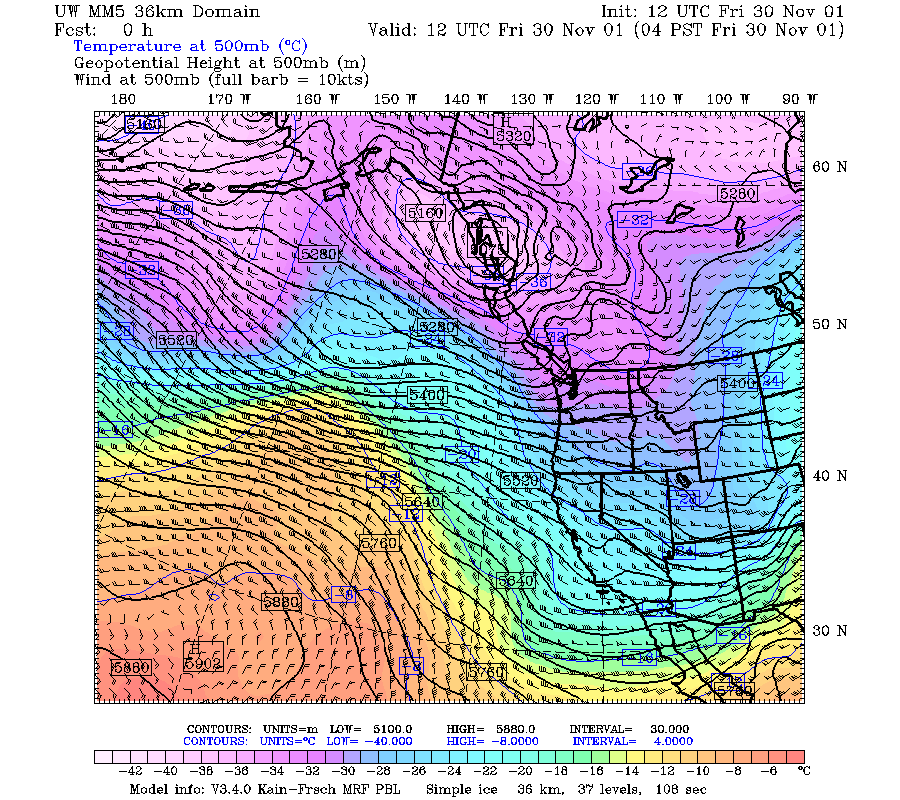
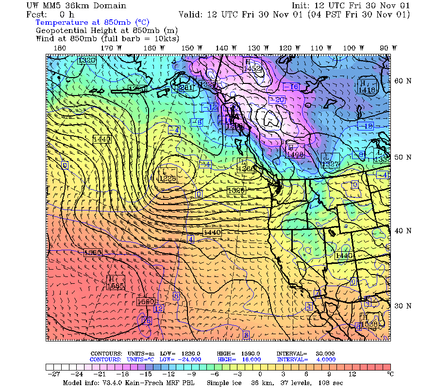
The third short wave in this rapid succession of frontal systems passed through during the period 0900 UTC 30 November and 2100 UTC 1 December 2001. A 500 mb trough formed over the ocean to the west of Oregon (Fig. 1a), moved westward as it intensified (Fig. 1b), and was located so that the 500 mb jet was over Oregon at 1200 UTC on 1 December (Fig. 1c). The accompanying 850 mb trough formed (Fig. 2a) and moved westward while intensifying (Fig. 2b) until it was situated with strong south southeasterly warm advection over Oregon at 1200 UTC on 1 December (Fig. 2c). The surface low was initially about 987 mb (Fig. 3a). It deepened to 980 mb by 0000 UTC on 1 December (Fig. 3b), and further deepened to 973 mb by 1200 UTC, when it was centered just west of Vancouver Island (Fig. 3c). The infrared satellite imagery showed an enhanced mesoscale cloud area (Fig. 4a) associated with the trough. This feature intensified and was moving over the radar area at 1500 UTC 30 November (Fig. 4b), just before the leading edge of the warm-frontal clouds arrived over the area.
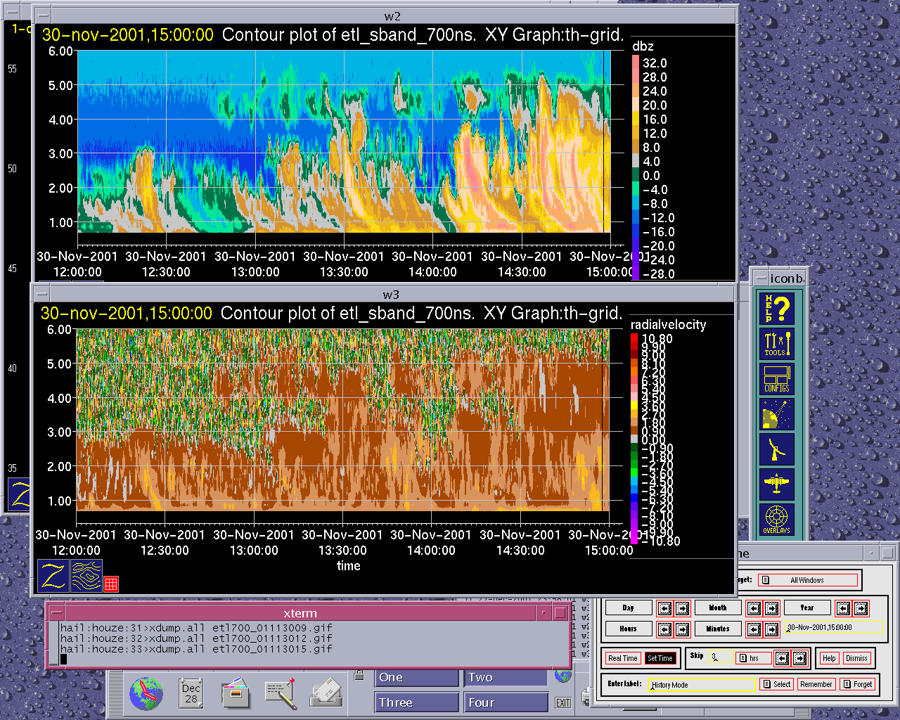
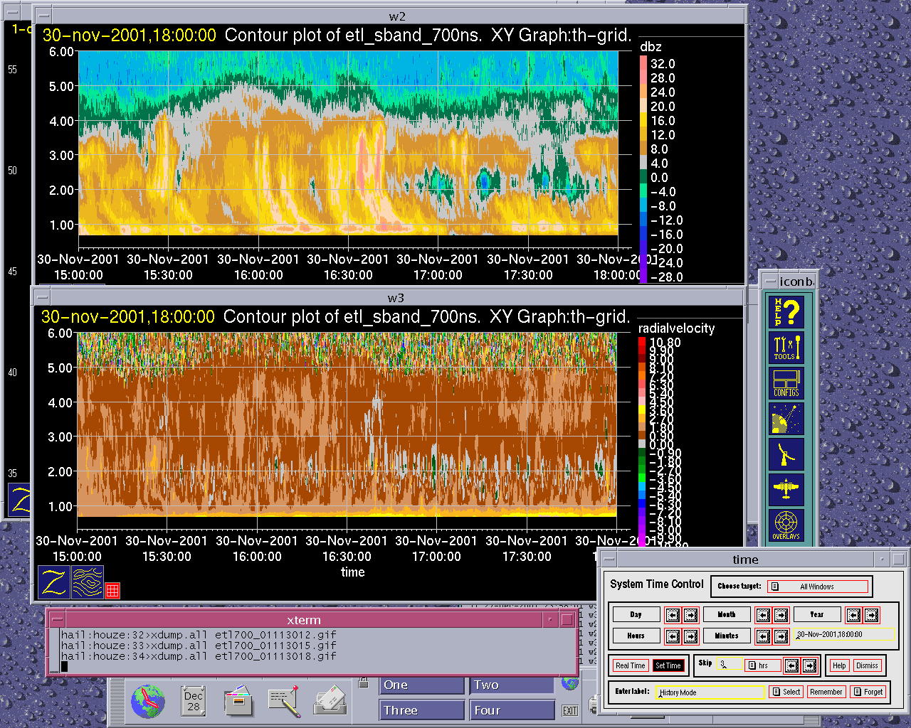
The ETL S-band profiler observations from 1400-1700 UTC showed the precipitation to be in a nearly continuous layer of snow containing convective fallstreaks extending downward from about 4 km AGL into a bright band located just above the ground (Fig. 7a, Fig. 7b). At about 0000-0300 UTC the warm-frontal portion of the frontal cloud system was moving across the S-Pol radar area (Fig. 4c, Fig. 4d). The S-band profiler showed a continuous layer of cloud with a bright band rising from about 1.0 to 1.2 km AGL in this warm frontal zone (Fig. 7c). In the apparent warm sector, the S-band profiler showed deeper and more discrete convection with a melting level at about 1.3 km (e.g., Fig. 7d). From 0900-1500 UTC 01 December, satellite imagery suggested that the cold-frontal portion of the cloud system was moving across the radar area (Fig. 4e, Fig. 4f). The S-band profiler showed a continuous layer of precipitation with the bright band dropping rapidly from 1.3 down to about 0.8 km AGL (Fig. 7e). By 1800 UTC the postfrontal region of convective cloudiness was passing over the region (Fig. 4g), and the S-band profiler was showing discrete convective cells (Fig. 7f). By 2100 the comma of the bent back occlusion was moving over the S-Pol area (Fig. 4h). The leading portion of the frontal cloud system had SE-NW oriented bands of enhanced radar echo at 0300 UTC 1 December (Fig. 5a).
By 0600 UTC the regions of enhanced echo were more globular (Fig. 5b). By 0900 UTC a band of strong echo, oriented roughly north-south, was just west of the S-Pol radar (Fig. 5c). At 1200 UTC a continuous broad region of echo, apparently associated with the front, was centered over S-Pol, with the bright band evident near the radar location (Fig. 5d). At 1500 UTC the back edge of the continuous frontal echo was over the mountains with cellular postfrontal echo moving in behind it (Fig. 5e). The ETL S-band profiler showed the echo associated with the frontal band aloft and lowering to the surface from 0900-1200 UTC 1 December (Fig. 6a). From 1200-1500 UTC, the echo seen by the S-band profiler was in a thick continuous layer with the bright band dropping as the colder air moved in (Fig. 6b). From 1500-1800 the echo seen by the profiler became a pattern of discrete convective cells (Fig. 6c).
Convair-580 Summary
No flight
P-3 Summary
No flight
S-Pol Radar Summary
The S-Pol radar was run continuously in the same mode of operation for the length of the field project.
Summary of Mobile Upstream Sonde Launches
Launch times:
No launches
Summary of Leeside Sonde Launches
Launch times:
No launches
Summary of NWS Sonde Launches from Salem (SLE)
Launch times:
1200 UTC 30 Nov (standard)
0000 UTC 01 Dec (standard)
1200 UTC 01 Dec (standard)
Summary of Snow Crystal Ground Measurements
Measurement times:
No Measurements


