IMPROVE-2
Improvement of Microphysical Parameterization through Observational Verification Experiment - 2
The goal of the 2nd Improvement of Microphysical PaRameterization through Observational Verification Experiment (IMPROVE-2) study was to focus on orographic lifting as the primary precipitation generating mechanism. This required a mountain range that was wide and high enough to perturb the cross-barrier flow to an extent that significant orographic enhancement of precipitation occurred, but that was also relatively isolated and 2D, so that complicated 3D flow regimes and interactions between flows generated by multiple ridges were minimized. Additionally, such a mountain range needed to experience a high frequency of synoptic weather patterns provided a moist cross-barrier flow and copious orographically enhanced precipitation during the wintertime.
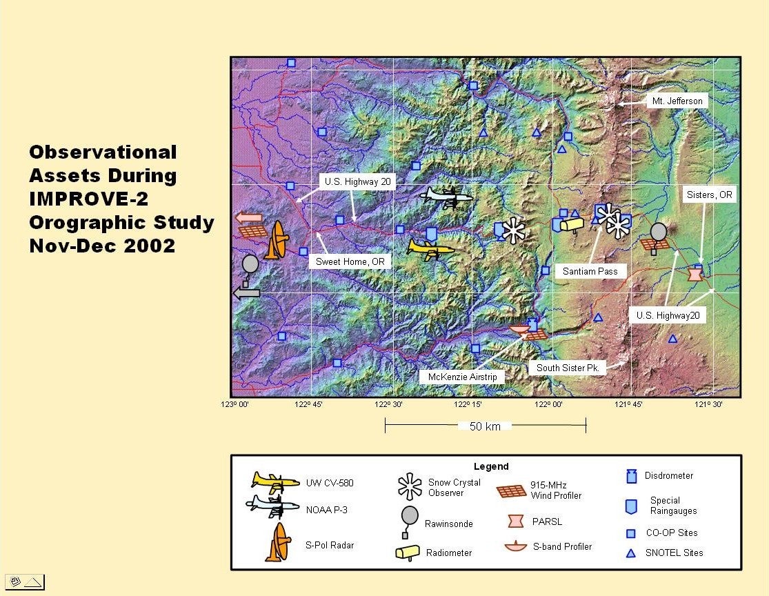
A location that satisfied these requirements was an approximately 55 km-long segment of the Cascade Mountains between Mount Jefferson and North Sister Mountain in west central Oregon (see map below). It consists of essentially one north/south ridge, approximately 2000 m high. Other than minor foothills on either side, the range is reasonably 2D. The location was also sufficiently close to Seattle so that the University of Washington (UW)’s Convair-580 research aircraft could operate out of its home airport in the Seattle area, which is a 50-minute flight from the study area. The site had good road access for deployment of ground-based observations, but was sufficiently distant from major commercial flight paths to permit good flexibility in deploying research aircraft flight tracks.
In terms of orographic weather systems, situations were sought that provided strong, moist cross-mountain flow for a period of several hours, that minimized embedded deep convection, and that provided a variety of precipitation growth conditions for exercising the MM5 model. With regard to the best time period for the orographic field study, the climatological precipitation record at Santiam Pass, Oregon (located roughly in the middle of the proposed ridge—see map) indicated a strong precipitation maximum (>10 mm precipitation per day) from late November through early January. With regard to the frequency of targeted weather situations, the precipitation record at Santiam Pass showed that daily precipitation in excess of 10 mm could be expected on 2.7 days per week, roughly consistent with the passage of frontal systems through the area during that time of year (2.8 per week, based on a survey of 3-hourly surface maps from 5 different years). Therefore, over a period of four weeks, from 26 November - 22 December 2001, 10-12 observable weather systems were expected to pass through the study area. As it turned out, the winter of 2001/2002 was wetter than average, and fifteen weather systems were studied with flight operations, even with self-imposed restriction of operating only between 7 AM and 10 PM.
PROJECT OPERATIONS
As in IMPROVE-1, the UW Department of Atmospheric Sciences in Seattle was the Forecasting and Operations Control Center (FOCC) for IMPROVE-2. Between the Intensive Observing Periods (IOPs), the NCAR S-Pol radar was used for surveillance of incoming storms, and this radar imagery was available to forecasters at the FOCC. When forecasts indicated that a frontal system was approaching within ~200 km of the Washington Coast, 3-hourly releases of rawinsondes were commenced at Salem, as well as at the UW mobile rawinsonde unit and the NCAR ISS installation at Black Butte, OR. Ice crystal observers began taking measurements near Santiam Pass, OR, when precipitation commenced.
The Convair-580 and P-3 aircraft departed from Paine Field, Washington, when the S-Pol radar showed precipitation features of interest making landfall on the Oregon coast. The Convair-580 was guided into precipitation features of interest off the Washington Coast by air-to-ground communications with a scientist at the S-Pol radar site who had real-time displays of the S-Pol radar images with the location of the Convair-580 overlaid. The Convair-580 basic flight pattern was a vertical stack of horizontal legs, starting near cloud top, and working down to the minimum safe altitude over the terrain, from close to the ocean surface to the top of the cloud system or to the maximum altitude of the Convair-580 (~7.25 km), with the aircraft generally moving with the ambient flow as it descends. Meanwhile, the P-3 flew a "lawn-mower" pattern of north-south legs at minimum safe altitude over the terrain to measure the Doppler velocity structure over the entire study area. The P-3 also was used on some flights to perform microphysical legs as described above for the Convair-580.
 |
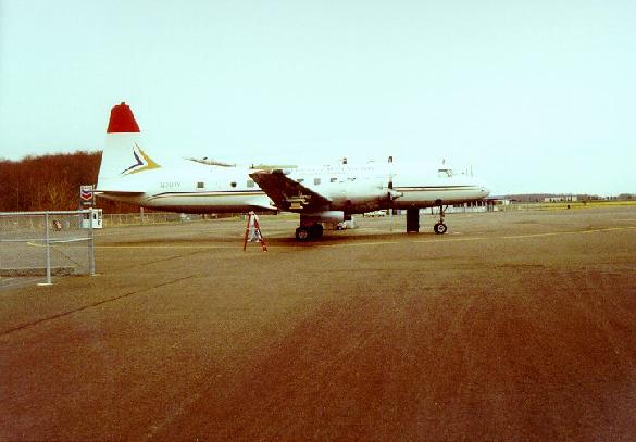 |
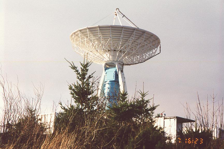
| S-Pol radar on Scott Mountain | Convair-580 |
OBSERVATIONS/DATA
Measurements were obtained in sixteen (16) Intensive Observing Periods (IOPs) during IMPROVE-2. The IOPs covered extratropical cyclones as well as orographic precipitation and comma clouds. Detailed vertical airborne profiles and airborne Doppler radar measurements were obtained in warm-frontal, warm-sector, pre-occlusion, pre-cold frontal, cold-frontal, occluded-frontal, post-frontal, and wide cold-frontal precipitation. To see a complete list of IOPS, please visit the University of Washington's Improve-2 IOP Menu.
| Aircraft | UW Convair-580, NOAA P-3 |
|---|---|
| Model | NOAA Aviation Forecast (AVN) Model output (model runs initialized every 6 h, with forecast data every 3 h out to 60 h) |
| Model | NOAA Eta Forecast Model output (model runs initialized every 6 h, with forecast data every 3 h out to 60 h) |
| Model | Compiled Observations for MM5 Initialization. All available surface and upper-air (excluding ACARS) observations within the UW MM5 Domain-1 area during IMPROVE-2 |
| Model | UW Mesoscale Regional Model (MM5) output (MMOUT files only for domains 2 and 3, hrs 12-24, every 3 h. Imagery for all three domains, 3-h out to 60 h) |
| Radar | NCAR S-band dual-polarized (S-Pol) deployed at the lower western foothills of the Cascade Mountains |
| Radar | NWS NEXRAD Radars at Seattle, WA (KATX), Portland, OR (KRTX), Medford, OR (KMAX), Spokane, WA (KOTX), and Pendleton, OR (KPDT) |
| Radiometer | NCAR Scanning Microwave Radiometer deployed just upstream of the Cascade crest |
| Remote Sensing | Pacific Northwest National Laboratory (PNNL) Remote Sensing Laboratory (PARSL). Site at the Sisters Airport, OR, included: 94-GHz and 35-GHz vertically pointing radars, a dual wavelength LIDAR, surface meteorology and accumulated precipitation, a suite of broadband radiometers, an infrared thermometer, a Yankee Multifilter Rotating Shadowband Radiometer (MFRSR), a Yankee Total Sky Imager (TSI), a Radiometerics Microwave Radiometer (MWR), and a Vaisala ceilometer. |
| Profiler | NOAA/ETL S-band vertical profiler located at the McKenzie Bridge Airstrip on the windward side of the Cascade Range. |
| Profiler | 2 NOAA/ETL wind profilers sites [including a 915-MHz Wind Profiler, a Radio-Acoustic Sounding System (RASS), and surface meteorology] at Newport, OR, and McKenzie Bridge (collocated with the ETL S-band Profiler) |
| Satellite | GOES-10 Imagery (1-km, 4-km, and 8-km Visible; 4-km and 8-km IR; and 4-km and 8-km Water Vapor) |
| Surface | UW Rainguage Network (five sites along Oregon's Highway 20) |
| Surface | Ground-based snow crystal observations from three ground observers during IOPs at several locations near the Cascade crest. |
| Surface | UW Distrometers collocated with the ETL S-band and wind profilers at McKenzie Bridge |
| Surface | METAR worldwide surface weather reports |
| Upper Air | 2 NCAR Integrated Sounding Systems (ISS). The first (ISS-2) at Irish Bend, OR, included a 915-MHz Profiler, RASS, and Surface Meteorology. The second (ISS-3) at Black Butte Ranch, OR, included a 915-MHz Profiler, Sondes, and Surface Meteorology. The 915-MHz Profilers were operated in two modes, low and high. |
| Upper Air | UW Mobile Rawinsonde Unit deployed in the Willamette Valley in western Oregon, upstream of the Cascade Mountains. Only a single location was used for each IOP |
| Upper Air | NWS rawinsonde at Salem, OR. Normal 00 and 12 UTC releases plus special 3-h intervals during IOPs. Other routine NWS station rawinsondes at 00 and 12 UTC for entire period of IMPROVE-2 |
NETWORK MAP
 |