IOP 9: 01-02 February 2001
Time Period of IOP
1500 UTC 01 Feb. 2001 - 1745 UTC 02 Feb. 2001
Overview of IOP
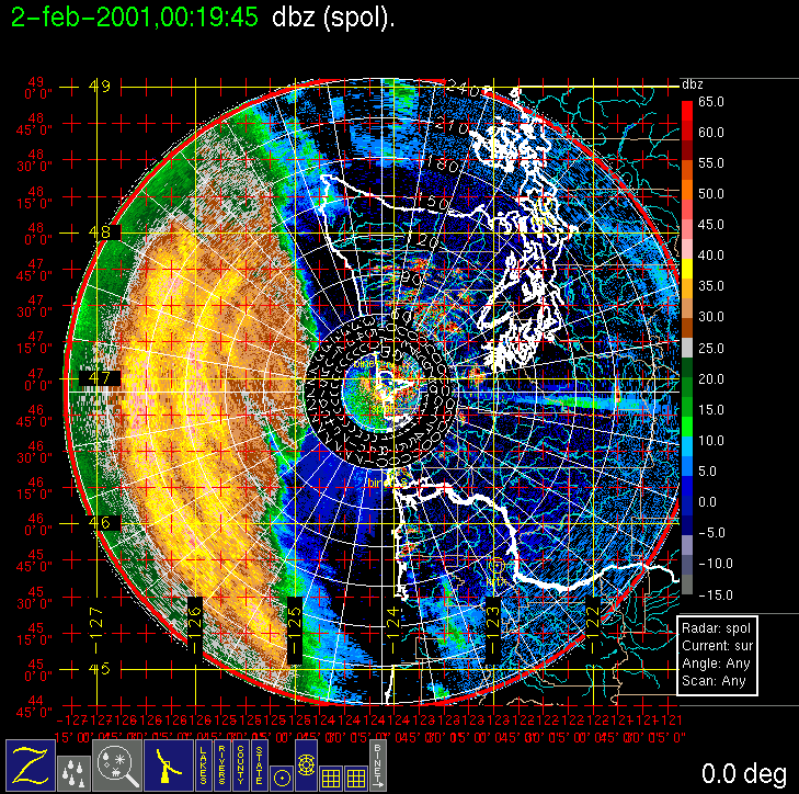
During early to mid-week, forecast models were consistently showing a substantial storm system to be making landfall on the Washington Coast on (Thursday) 01 February 2001. PACJET planned their "super IOP" for this storm, including special upstream dropsondes on Wednesday afternoon (0000 UTC Thursday), and the Winter Storm Reconnaissance Program also deployed upstream sropsondes at the same time. Wednesday evening's model runs showed an onshore frontal passage at 8 or 9 pm local time. A Convair-580 flight was planned with an earliest door closed of noon local time on Thursday. On Thursday morning this was moved to 3 pm local time as the models appeared to slow the system down by a few hours compared to the previous run. The main part of the precipitation, which was ahead of the surface front, entered the study area in mid-afternoon on Thursday (see IR satellite image and long-range S-Pol surveillance scan). The aircraft took off at ~2:30 pm local time and intercepted the extensive precipitation band offshore, making several legs at 3,000-ft intervals from the surface to 21,000 ft. We successfully utilized a new stack strategy that replaced spiral climbs outside the area of interest with steady climbing legs that passed through the area of interest. The aircraft landed at Hoquiam in anticipation of a surface frontal precipitation band, but no significant band appeared, so the Convair-580 returned to Paine Field via the Olympic Mountain transect. A gradual surface frontal windshift appeared on the Westport profiler around 0700 UTC on Friday 2 February, but no significant precipitation band was associated with it.
Convair-580 Summary
UW Flight Number:
1856 ( First Flight for this IOP)
Period of Flight:
2224-0333 UTC, 01-02 February 2001
Main Accomplishments of Flight:
Measurements from 1,000 to 21,000 ft in pre-frontal rainband in dual-Doppler area. Landed at Hoquiam in heavy rain.
Instrument Problems:
Poor images on SPEC CPI.
Flight Scientist:
Peter Hobbs
Approximate UTC Timeline (Local time = UTC – 8 hours) Activity for UW Flight 1856:
2224 Engines on.
2245 Take off from Paine Field
2245-2249 Climb to 8,000 ft.
2249-2315 Transit to Westport at 9,800 ft.
2315 Over S-Pol radar at Westport.
2315-0000 Westport à 46 deg 22'/126 deg 10' at 1,000 ft.
0006-0018 46 deg 22'/126 deg 10' to 48 deg 34'/125 deg 40'. Climbing steadily from 1,000 to 3,200 ft.
0018-0025 Spiral up at 48 deg 34'/125 deg 40' to 6,700 ft (–2 deg C).
0028-0047 Head southwest at 6,700 ft to 46 deg 20'/126 deg 20'.
0047-0058 Head northeast from 46 deg 20'/126 deg 20' to 46 deg 30'/125 deg 48'. Climbing steadily from 6,700 to 9,500 ft (–6 deg C).
0059-0111 Head southwest at 9,500 ft.
0112-0123 Head northeast to 46 deg 34'/125 deg 20'. Climbing steadily from 9,500 to 12,500 ft (–9 deg C).
0127-0135 Head southwest to 46 deg 30'/125 deg 45' at 12,500 ft.
0137-0145 Head northeast to 46 deg 40'/125 deg 07' climbing steadily to 15,000 ft.
0148-0155 Head southwest at 15,000 ft (–13 deg C) to 46 deg 34'/125 deg 27'.
0200-0213 Head northeast to 46 deg 47'/124 deg 37' climbing to 18,000 ft (–18 deg C).
0213-0222 Head southwest at 18,000 ft to 46 deg 40'/125 deg 00'.
0225-0232 Head northeast to 46 deg 50'/124 deg 25' climbing steadily to 21,000 ft (–24 deg C).
0235-0247 Head southwest at 21,000 ft to 46 deg 40'/125 deg 00'.
0247-0307 Head northeast descending at ~1,500 ft/min to end up at low level over Westport.
0330 Land at Hoquiam (heavy rain).
0333 Engines off.
UW Flight Number:
1857 (Second Flight for this IOP)
Period of Flight :
0449-0556 UTC, 2 February 2001
Main Accomplishments of Flight:
Return flight to Paine Field. Good measurements on west side of Olympics in rainband studied in UW Flight 1856.
Instrument Problems:
Some SPEC CPI dropouts.
Flight Scientist:
Peter Hobbs
Approximate UTC Timeline (Local time = UTC – 8 hours) Activity for UW Flight 1857:
0449 Engines on.
0500 Take off from Hoquiam.
0514 Over Humptulips.
Humptulips to Protection Island.
Land Paine Field.
0556 Engines off.
S-Pol Radar Summary
1500 UTC Thur 01 Feb.:
Radar switched from dual-pol to long-range mode.
Scan cycle switched from NWS-Surveillance to Long Range
(with RHIs after 1600 UTC).
0045 UTC Fr 02 Feb.:
Radar switched from long-range to dual-pol mode.
Scan cycle switched from Long Range to Research.
1745 UTC Fr 02 Feb.:
Scan cycle switched from Research to NWS-Surveillance.
Summary of Navy Sonde Launches from Westport
Launch times:
2311 UTC Thur 01 Feb.
0350 UTC Fr 02 Feb.
1029 UTC Fr 02 Feb.
Notes: All sondes launched successfully.
Summary of NWS Sonde Launches from Quillayute (UIL) and Salem (SLE)
Launches are generally started ~1 h before a standard 3-hourly synoptic time, so some sondes are reported as occurring
1 h before the standard synoptic hour.
UIL Launch Times:
0000 UTC Fr 02 Feb. (standard)
0200 UTC Fr 02 Feb. (special)
0600 UTC Fr 02 Feb. (special)
0800 UTC Fr 02 Feb. (special)
1200 UTC Fr 02 Feb. (standard)
SLE Launch Times:
0000 UTC Fr 02 Feb. (standard)
0200 UTC Fr 02 Feb. (special)
0600 UTC Fr 02 Feb. (special)
0800 UTC Fr 02 Feb. (special)
1200 UTC Fr 02 Feb. (standard)
Note: UIL sonde at 2100 UTC not launched due to equipment problems.


IMPROVE (University of Washington)