IOP 6: 20-21 January 2001
Time Period of IOP
0500 UTC 20 Jan 2001 - 2122 UTC 21 Jan 2001
Overview of IOP
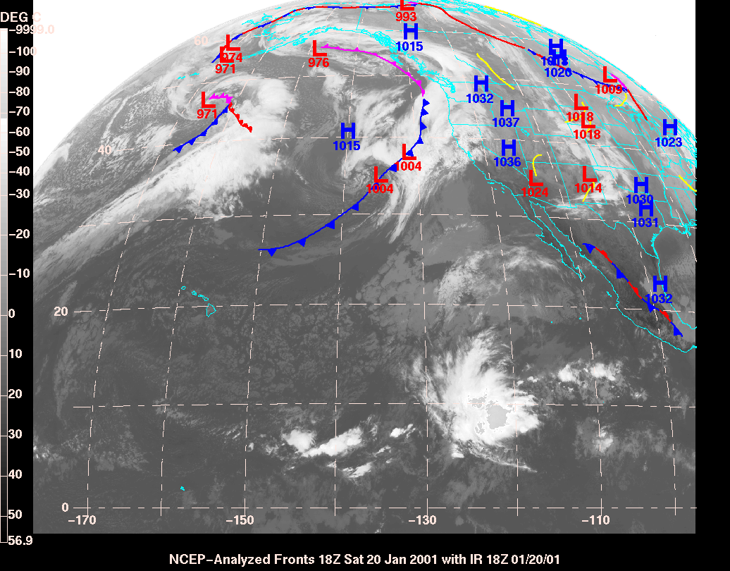
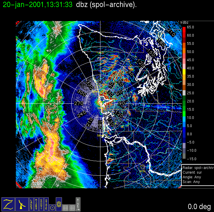
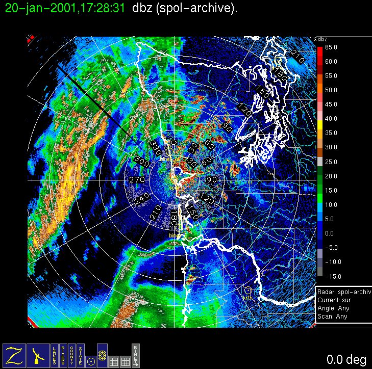
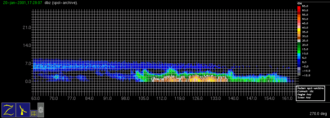
On (Friday) 19 January a meridionally elongated trough and associated cloud band were forecast to move through the study area on (Saturday) 20 January, with some uncertainty as to wave or low center development along the band. A Convair-580 flight was planned with a 7 am local time doors closed on Saturday. The weather system approached the Washington coast Saturday morning as expected but, as with the previous IOP, by 5 am local time on Saturday, the radar showed that the first rainband had come in earlier than forecast, precluding an aircraft study of that band. The flight was postponed until another precipitation feature was identified on the S-Pol radar display. Models indicated a low development off the Oregon Coast, with a redevelopment of precipitation along the trailing end of the early morning rainband late Saturday. Complete cancellation of the flight was considered, but then a shallow occluded-frontal rainband developed behind the early morning band (due west of the radar in the image), and the Convair-580 was sent to intercept it. An RHI cross section through this band shows that the band formed underneath an overhanging veil of ice from the first rainband (which at this time is off the radar image to the left). A complete aircraft stack was executed within the southern end of the rainband up to 15,000 ft altitude. Redevelopment of precipitation off the Oregon coast seemed to be occurring sooner than the models had forecast (the 1200 UTC MM5 run seemed to be about 5 h behind reality but in good agreement structurally), so the Convair-580 landed at Hoquiam for a brief layover. It was then sent out on a N-S track just off the Oregon and Washington coast to execute a vertical stack in the new rainband (just offshore of the Oregon/Washington border in the figure), which weakened somewhat with time during the flight. The flight was concluded with an Olympic Mountain Transect at ~10,000 ft altitude along the standard track between Humptulips and Protection Island.
Convair-580 Summary
UW Flight Number:
1852 (First flight for this IOP)
Period of Flight:
1635-2028 UTC, 20 January 2001
Main Accomplishments of Flight:
Measurements in rainband along and to east of advancing occluded front.
Instrument Problems:
Some CPI computer shutdowns.
Flight Scientist:
Nick Bond
Approximate UTC Timeline (Local time = UTC – 8 hours) Activity for UW Flight 1852:
1635 Engines on.
1648 Take off from Paine Field
1655-1705 In moderate precipitation at 10,000 ft over south Puget Sound. Cloud radar shows down to 4,000-7,000 ft.
1721 Start of low-level leg (2,000 ft). No precipitation but overcast. All instruments okay.
1810 End of low-level leg to southwest.
1814 Start of leg at 6,000 ft.
1823 End of 6,000 ft.
1827 Start of 7,500 ft leg.
1840 End of 7,500 ft leg (southwest point).
1843 Start of 9,000 ft leg.
1847 System down.
1856 System back up.
1900 Repeat 9,000 ft leg heading southwest. By 1905 UCT all instruments functional.
1916 End of 9,000 ft leg.
1919 Begin 10,500 ft leg. No precipitation initially.
1930 End 10,500 ft leg.
1933 Dropping from 9,000 ft to 3,500 ft.
1937 Leveling out at ~3,000 ft.
1945 Southwest end of 3,000 ft.
1948 Start at 500 ft at southwest end.
1951 End of 500 ft. Climbing to 6,000 ft (just above 0 deg C level).
1958 End of 6,000 ft (not much precipitation).
1959 Heading for Hoquiam.
2015 System taken down.
2022 Touch down at Hoquiam.
2028 Engines off.
UW Flight Number:
1853 (Second flight for this IOP)
Period of Flight:
2128-0050 UTC, 20-21 January 2001
Main Accomplishments of Flight:
Measurements in encroaching warm-frontal type rainband (same system as Flight 1852).
Flight Scientist: Nick Bond
Approximate UTC Timeline (Local time = UTC – 8 hours) Activity for UW Flight 1853:
2128 Engines on
2136 Take off from Hoquiam
2155 Beginning of low-level run at 1,000 ft
2214 End of low-level run. Turn and climb.
2219 Start of 5,500 ft leg
2234 End of 5,500 ft leg. Turn and climb.
2238 Begin run at 7,500 ft.
2249 End of 7,500 ft climb, turn.
2252 Begin run at 9,500 ft.
2304 End of 9,500 ft run climb & turn.
2310 Start 12,000 ft run.
2318 End of 12,000 ft run climb & turn.
2321 Start 15,000 ft run (at 14,000 ft at initial point).
2330 End of 15,000 ft run.
2336 Start 18,000 ft run.
2347 End 18,000 ft climb & turn.
2350 Start 21,000 ft.
0000 End 21,000 ft. Still in deep cloud. Spiraling down for Olympic Transect.
0015 Begin Olympic Transect at 10,000 ft. Enhanced winds. Precipitation near top TRB and weak winds in lee.
0031 End of Olympic Transect.
0045 Touch down at Paine Field
0050 Engines off.
S-Pol Radar Summary
Scan cycle switched from NWS-Surveillance to Long Range
(with RHIs after 1345 UTC).
2125 UTC Sat 20 Jan:
Scan cycle switched from Long Range to Research.
2122 UTC Sun 21 Jan:
Summary of Navy Sonde Launches from Westport:
1456 UTC Sat 20 Jan
1840 UTC Sat 20 Jan
0005 UTC Sun 21 Jan
Notes: First launch attempt at 1800 UTC Sat 20 Jan failed due to string coming loose from balloon shortly after release. Sonde fell in ocean and balloon burst.
Summary of NWS Sonde Launches from Quillayute (UIL) and Salem (SLE)
UIL Launch Times:
1400 UTC Sat 20 Jan (special)
1800 UTC Sat 20 Jan (special)
2000 UTC Sat 20 Jan (special)
0000 UTC Sun 21 Jan (standard)
SLE Launch Times:
1800 UTC Sat 20 Jan (special)
2000 UTC Sat 20 Jan (special)
0000 UTC Sun 21 Jan (standard)
0200 UTC Sun 21 Jan (special)
Notes: 1) SLE sonde at 1500 UTC not launched because sonde launcher had car problems en route to SLE site.
2) UIL sonde at 0300 UTC not launched due to equipment problems.


IMPROVE (University of Washington)