IOP 8: 28-29 January 2001
Time Period of IOP
0525 UTC 28 Jan 2001- 1600 UTC Mo 29 Jan 2001
Overview of IOP
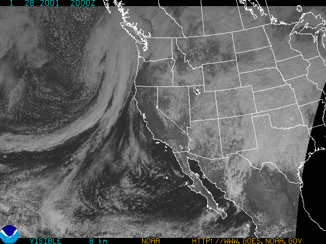
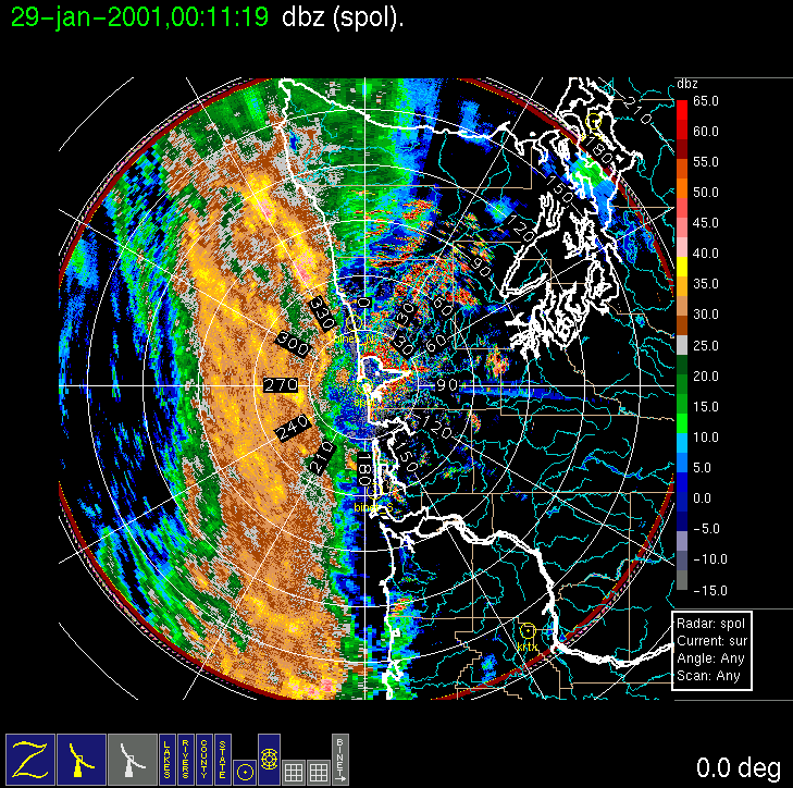
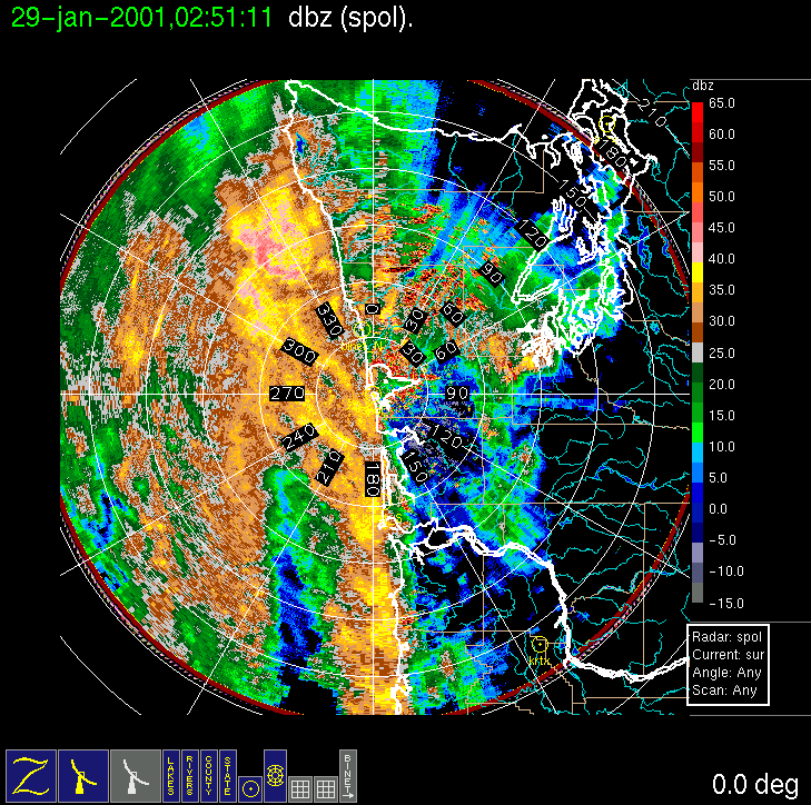
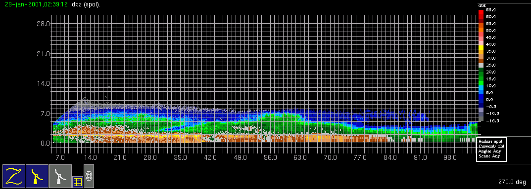
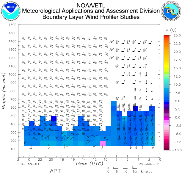
On (Saturday) 27 January forecast models were developing a frontal system associated with an elongated low that was forecast to pass through central Vancouver Island during Sunday afternoon. A solid band of N-S oriented precipitation was expected to pass over the study area by afternoon but, on account of some uncertainty as to the timing of the arrival of the precipitation, a flight was planned for Sunday with a doors closed time of 8 am local time. By Sunday morning a low pressure system was evident in satellite imagery, and by noon a pattern of two distinct cloud bands, each a couple of hundred kilometers wide and oriented parallel to each other, could be seen offshore of Washington State in the visible satellite image. The 1200 UTC MM5 model run also indicated a similar pattern in expected precipitation. After evaluating the development of the first band on long-range radar, it was concluded that the second band would likely be stronger, and the Convair-580 doors closed time was delayed to 2 pm local time. The first rainband stalled in its eastward progression and was in the process of being overtaken by the developing second band when the Convair-580 took off at 2312 UCT on Sunday 28 January. The aircraft arrived at the first rainband shortly before 2400 UCT flying in a due east direction from the S-Pol radar site about 40 kilometers to 160 km offshore. Eight stacked legs were flown from a starting elevation of 1,000 ft to above freezing level at ~4,000 ft, and thereafter in 2,000 ft. climbs to a closing altitude of ~21,000 ft. A new strategy of gradual continuous climbs between legs was employed to give a better idea of storm structure. After the first rainband was intersected, it was determined that not enough time remained to do a complete set of stacked legs on the developing second band so the aircraft spiraled downward through the second band from an altitude of 13,000 ft. RHIs of the the complete line of precipitation reveal cloud tops of ~7 km and a melting layer or "bright band" dropping with distance from the coast. Convair-580 observations were completed by 0400 UCT on 29 January. The S-Pol radar continued to operate and observed a narrow cold-frontal band of heavy precipitation (~50 dBZ maximum) behind the second band by 0730 UCT on 29 January. This band had a distinct south-to-west windshift on Doppler velocity, dramatically evident in the NOAA wind profiler observations for Westport. The heavy precipitation from this final band moved onshore by 0930 UCT on Monday. 29 January.
Convair-580 Summary
UW Flight Number:
1855
Period of Flight :
2358-0445 UTC, 28 January 2001
Main Accomplishments of Flight:
Measurements in two rainbands ahead of strong cold front. Transect of Olympic Mountains on return to Paine Field.
Instrument Problems:
Lots of poor images on SPEC CPI.
Flight Scientist:
Peter Hobbs
Approximate UTC Timeline (Local time = UTC – 8 hours) Activity for UW Flight 1855:
2258 Engines on.
2312 Take off from Paine Field
2312-2344 Transit to Westport (ice crystal fallout—columns—at 9,700 ft). Freezing level ~4,000 ft.RAINBAND #1
2345-0005 Westbound at 1,000 ft from Westport to 46 deg 54'/125 deg 11' (A to B).
0005-0020 Eastbound climb from 1,000 to 3,000 ft. Finish at 46 deg 54'/124 deg 28' (B to A).
0020-0035 Westbound at 3,000 ft to 46 deg 54'/125 deg 05' (A to B).
0035-0049 Eastbound, climb from 3,000 to 6,000 ft, end at 46 deg 54'/124 deg 17' (B to A).
0049-0102 Westbound at 6,000 ft (warming to west) to 46 deg 54'/124 deg 55' (A to B).
0104à0114 Eastbound climbing from 6,000 to 9,000 ft to 46 deg 54'/124 deg 13' (B to A).
0114à0126 Westbound at 9,000 ft to 46 deg 54'/124 deg 42' (A to B). (–6 deg C at B.)
0128-0137 Eastbound, climbing from 9,000 to 12,000 ft, to 46 deg 54'/124 deg 00' (B to A).
0140-0150 Westbound at 12,000 ft to 46 deg 54'/124 deg 36' (A to B).
0153-0204 Eastbound, climbing from 12,000 to 15,000 ft (–10 deg C), to 46 deg 54'/123 deg 51' (B to A).
0209-0218 Westbound at 15,000 ft (–14 deg C) to 46 deg 54'/124 deg 23' (A to B).
0221-0231 Eastbound, climbing from 15,000 to 18,000 ft, to 46 deg 54'/123 deg 36' (B to A). Near cloud top at westerly point and 18,000 ft (–20 deg C).
0235-0244 Westbound at 18,000 ft to 46 deg 54'/124 deg 07' (A to B)
0248-0256 Eastbound, climbing from 18,000 to 21000 ft, to 46 deg 54'/123 deg 21' (B to A). –28 C at 21,000 ft.RAINBAND #2
0306-0313 Head west at 21,000 ft to 46 deg 54'/124 deg 22' to Rainband #2.
0313-0402 Spiral down at 300 ft/min from 21,000 ft in Rainband #2. From 21,000 to 19,000 ft at fixed geographical location (46 deg 54'/124 deg 22'). Then from 19,000 to 3,000 ft drift to north with wind, until over coastline north of North BINET radar site. Descend from 13,000 to 10,000 ft on coastline. Then moved west to allow descent to 2,000 ft.
0405 Start climb to east for return to Paine Field.OLYMPIC MOUNTAIN TRANSECT
Passed over crest of Olympics (at ~9,000-10,000 ft) on return flight to Paine Field. Encountered considerable precipitation (Rainband #1?).0440 Land at Paine Field.
0445 Engines off.
S-Pol Radar Summary
0525 UTC Sun 28 Jan:
Radar switched from dual-pol to long-range mode.
Scan cycle switched from NWS-Surveillance to Long Range
(with RHIs after 1619 UTC).
2000 UTC Sun 28 Jan:
RHIs added to Long Range mode.
2300 UTC Sun 28 Jan:
Radar switched from long-range to dual-pol mode.
Scan cycle switched from Long Range to Research.
1600 UTC Mo 29 Jan:
Scan cycle switched from Research to NWS-Surveillance.
Summary of Navy Sonde Launches from Westport
Launch times:
2056 UTC Sun 28 Jan
0009 UTC Mo 29 Jan
0501 UTC Mo 29 Jan
Notes:
1) Test launch at 1800 UTC 25 Jan with PNNL Loran launcher was unsuccessful. Sonde was successfully tracked with Navy launcher.
2) Sonde launched at 0300 UTC 29 Jan failed at 800 hPa for unknown reason. No data from that sonde was provided.
Summary of NWS Sonde Launches from Quillayute (UIL) and Salem (SLE)
Launches are generally started ~1 h before a standard 3-hourly synoptic time, so some sondes are reported as occurring 1 h before the standard synoptic hour.
UIL Launch Times:
1400 UTC Sun 28 Jan (special)
1800 UTC Sun 28 Jan (special)
2000 UTC Sun 28 Jan (special)
0000 UTC Mo 29 Jan (standard)
0200 UTC Mo 29 Jan (special)
0600 UTC Mo 29 Jan (special)
0800 UTC Mo 29 Jan (special)
1200 UTC Mo 29 Jan (standard)
SLE Launch Times:
0300 UTC Mo 29 Jan (special)
0600 UTC Mo 29 Jan (special)
0800 UTC Mo 29 Jan (special)
1200 UTC Mo 29 Jan (standard)
Note: 2100 UTC Mo 29 Jan launch at SLE was not performed, for unknown reason.


IMPROVE (University of Washington)