IOP 3: 09-10 January 2001
Time Period of IOP
1300 UTC 09 Jan 2001 - 0230 UTC 10 Jan 2001
Overview of IOP
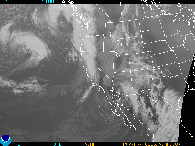
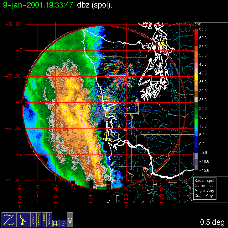
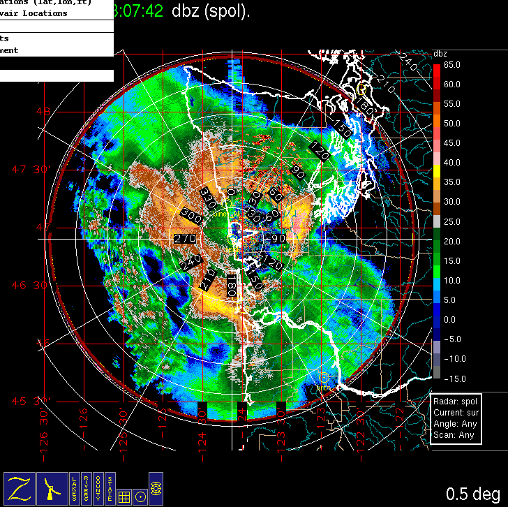
The forecast models for (Monday) 8 January showed a cold or occluded frontal band in the study area on (Tuesday) 9 January, although the models differed significantly on the timing. A doors closed time for the Convair-580 was initially set for 10 am local time Tuesday. The weather system did end up entering the study area around mid-day, so the original doors closed time was well chosen. An initial rainband, seemingly associated with a cold front aloft in an occluded system, was flown at several levels up to ~23,000 ft (de-icing was not needed). The Convair-580 landed at Hoquiam for re-fueling and a crew break. It then flew another rainband behind the first rainband (100 km southwest of the S-Pol radar in the figure). This second band appeared to be along the surface occluded front, and displayed radar returns up to 18,000 ft. The flight was completed with an Olympic Mountain transect at 10,000 ft, from south to north along 123 degrees 30 minutes west longitude.
Convair-580 Summary
UW Flight Number:
1848 (First flight for this IOP)
Period of Flight:
1734-2116 UTC, 9 January 2001
Main Accomplishments of Flight:
Vertical profile from near surface to top of pre-occluded front rainband.
Instrument Problems:
PMS 2-D cloud probe. SPEC CPI not installed.
Flight Scientist:
Nick Bond
Approximate UTC Timeline (Local time = UTC – 8 hours) Activity for UW Flight 1848:
1734 Engines on.
1742 Take off from Paine Field
1746 Freezing level over Puget Sound ~800 mb.
1755 Low-level fog in Puget Sound Basin. Winds only 10 m s–1 from 190 deg at 700 mb.
1758 Checked in with S-Pol. Coordinates of first run okay.
1801 Winds picking up 15 m s–1 from 200 deg
1806 Over Grays Harbor. Precipitation in sight ahead.
1810 Numerous whitecaps. Starting descent.
1813 800 mb, winds 180 deg at 18 m s–1, light chop. Surface winds from south to southeast.
181445 850 mb, 2 deg C, winds 200 deg at 20 m s–1.
1816-1832 Low-level run.
181645 In precipitation. HVPS picking it up.
1820 46 deg /20' 125 deg 11': new point for end of run (from communication. with radar).
1828 Winds from sea state 140 deg at 20 m s–1. 46 deg 40' /124 deg 30' new northeast point.
1834-1850 5,000 ft run.
1836 Good data from HVPS.
1843 Winds 170 deg 33 m s–1 at 825 mb.
1850 46 deg 20' /124 deg 56' new southwest point.
1853 Starting run to southwest at ~8,000 ft.
1853-1912 8,000 ft run.
1856 HVPS temporarily down. Winds 170 deg at 30 m s–1.
1858 HVPS back up.
1901 Light chop, winds 190 deg at 33-36 m s–1.
1905 Temperature dropped from –3.3 to –4.1 deg C. Winds seem frozen at times.
1912 Beginning climb for 11,000 ft.
1914-1915 46 deg 47' /124 deg 11' new northeast point.
1918-1929 11,000 ft run.
1920 Lots of small particles on HVPS. Temperature –8 deg C. Winds suspicious; fixed at 190 deg 33.4 or 36.0 m s–1.
1930 46 deg 26' /124 deg 44' southwest point for 14,000 ft.
1934-1952 14,000 ft run.
1934 Some flakiness in reverse flow temp and wind speed.
1937 Cabin pressure low O2.
1942 Reverse flow temperature mostly bad –13 to –14 deg C
1948 Cabin pressure back up.
1954 46 deg 46' /124 deg 13' near end point for 17,000 ft run.
1956-2007 17,000 ft. run.
2002 Correct temperature probably –17 deg C also showing –19.8 deg C. Winds 170 deg at 38.6 m s–1.
2009 Climbing to 20,000 ft. Temp –25.6 deg C, wind 180 deg at 36 m s-1
2010-2024 20,000 ft.
2015 Winds 180 deg at 33.4 m s–1. Close to forecasr value.
2028 Spoke with radar; planning possible landing at Hoquiam.
2034 Discussing second flight.
2041 Approaching cloud top last leg towards northeast never really got into clouds.
2048 Approach/descent into Hoquiam. Should provide good profile but HVPS not working.
2057 Getting good descent profile. Stable layer just above freezing level (isothermal). Mostly light some moderate chop. Freezing level about 3,100 ft.
2105-2109 Rough approach to Hoquiam below about 4,000 ft.
2111 Touch down at Hoquiam.
2115 Engines off.
UW Flight Number:
1849 (Second flight for this IOP)
Period of Flight:
2233-0202 UTC, 9-10 January 2001
Main Accomplishments of Flight:
Measurements in occluded front (same system as Flight 1848). Measurements across Olympic Mountains en route back to Paine Field.
Instrument Problems:
PMS 2-D cloud probe. SPEC CPI not installed.
Flight Scientist:
Nick Bond
Approximate UTC Timeline (Local time = UTC – 8 hours) Activity for UW Flight 1849:
2233 Engines on.
2240 Take off from Hoquiam.
2245-2318 Heading for first point 46 deg 25'/124 deg 45'. Light-moderate turbulence, moderate visibility/mile. Wind 160 deg 18-21 m s–1 at 1,500 ft. Temperature 1-4 deg C.
2301 Winds picking up slightly. Temperature 3-4 deg C.
2309 Still no sign of front except for perhaps lower cloud bases.
2311 Lower ceiling & visibility.
2314 Probably through wind shift.
2318 Quite noticeable cloud band with front from west side.
2320 Southwest end point near 45 deg 56' /125 deg 41'
2330 Heading back towards northeast, Temperature ~-2 deg C.
2330-2352 4,000 ft run.
2336 Hitting bursts of liquid H2O. Up to ~0.8 g m–3 liquid water New northeast point 46 deg 54'/124 deg 09'.
2342 Fairly large LWC ~0.4 g m–3.
2343 Pilots reporting some lift. Relatively cold ~–3 deg C.
2345 Temp. up, LWC down.
2351 Near or just above freezing level, low LWC.
2352 New southwest point 46 deg 39'/124 deg 29'
2355-0016 7,000 ft run.
2357 Winds 230 deg 21 m s–1, T -4 to -6 deg C
0006 Continuing on course.
0016 Climbing to ~10,000 ft.
0018-0027 10,000 ft run.
0020 New northeast point 46 deg 54' /124 deg 06'.
0025 HVPS having problems.
0027 HVPS back doing okay. Climbing to ~13,000 ft. Slacker winds at 10,000 ft through below.
0029 New southwest point 46 deg 42' /124 deg 26'.
0029-0040 13,000 ft. run.
0033 Winds 220 deg 18 m s–1. Temperature –14 to –16 C. 13,000 ft.
0035 Speed picking up ~26 m s–1.
0041 Broke out starting climb.
0043-0052 16,000 ft run.
0047 Temperature –20 to -23 C. Wind 180 at 31 m s–1. 16,000 ft.
0055-0101 19,000 ft run.
0057 Temperature –25 to –29C. Wind 190 at 28 m s–1. 19,000 ft. Still in precipitation.
0101 Climbing to 22,000 ft or higher.
0105-0114 22,000 ft run.
0113 South point 47 deg 00'/123 deg 30'. North point 48 deg 13'/123 deg 30'. Arranged for Olympic Transect.
0119 Lining up for Olympic Transect at 10,000 ft. Winds 190 at 18 m s–1. HVPS back okay.
0119-0140 Olympic Transect.
0123-0125 Temporarily shut data system, but data probably being recorded.
0130 Bad temperature (–17 deg to -18 C). Winds bad.
0136 Data looks okay. No turbulence in lee of Olympics.
0140 Little or no precipitation.
0151 Shutting down data system. Nine legs.
0157 Touch down at Paine Field.
0202 Engines off.
S-Pol Radar Summary
Scan cycle switched from NWS-Surveillance to Long Range.
1730 UTC Tues 09 Jan:
Scan cycle switched from Long Range to Research.
0230 UTC We 10 Jan:
Summary of Navy Sonde Launches from Westport
2021 UTC Tues 09 Jan
2357 UTC Tues 09 Jan
0200 UTC We 10 Jan
Notes: 1) Launch at 2225 UTC Tues 09 Jan recorded no data due to computer disk being full.
Summary of NWS Sonde Launches from Quillayute (UIL) and Salem (SLE)
Launches are generally started ~1 h before a standard 3-hourly synoptic time, so some sondes are reported as occurring 1 h before the standard synoptic hour.
UIL Launch Times:
2000 UTC Tues 09 Jan (special)
0000 UTC We 10 Jan (standard)
0200 UTC We 10 Jan (special)
SLE Launch Times:
2000 UTC Tues 09 Jan (special)
0000 UTC We 10 Jan (standard)
0200 UTC We 10 Jan (special)
Note: All sondes launched as requested.


IMPROVE (University of Washington)