IOP 11: 10-11 February 2001
Time Period of IOP:
0400 UTC 10 Feb. 2001 - 0921 UTC 11 Feb. 2001
Overview of IOP
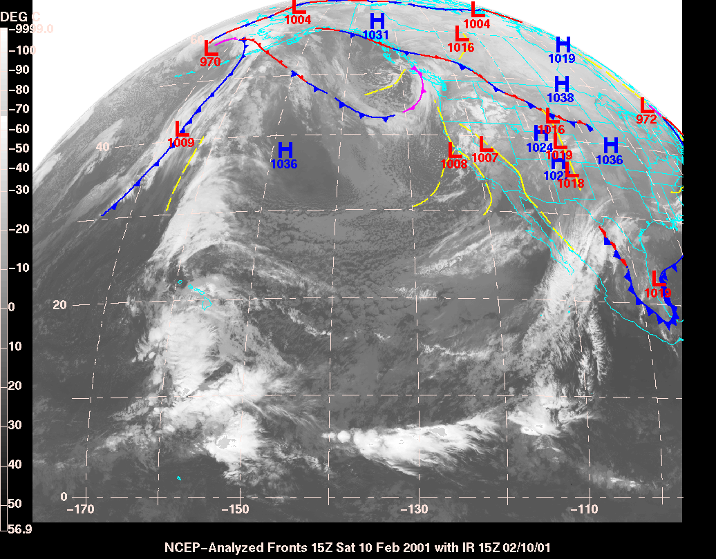
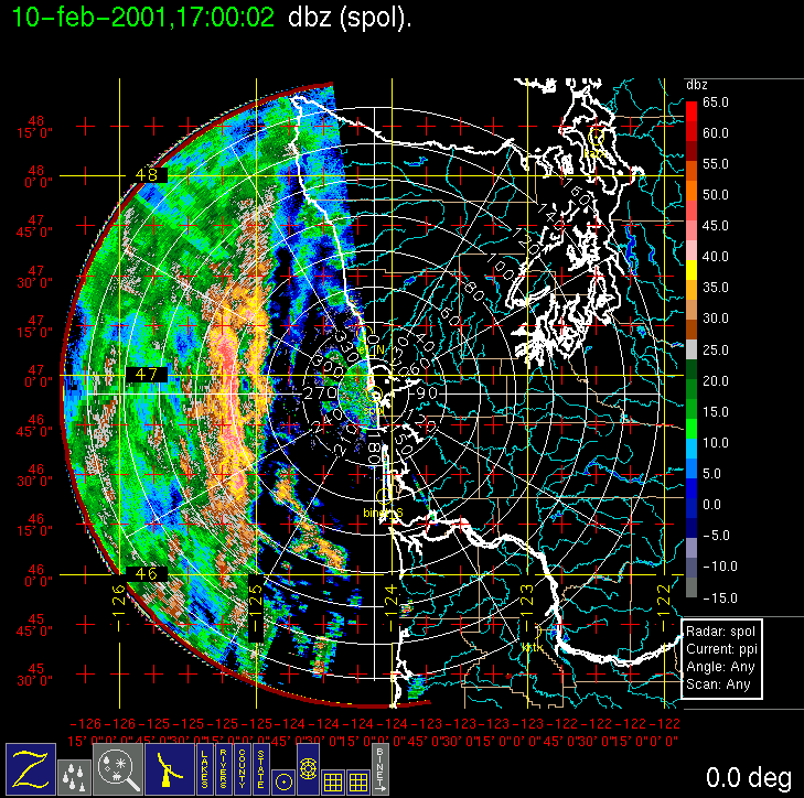
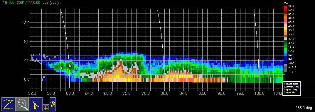
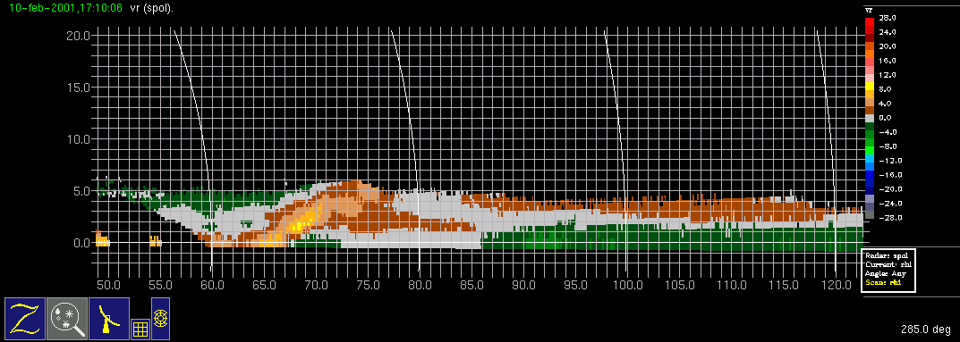
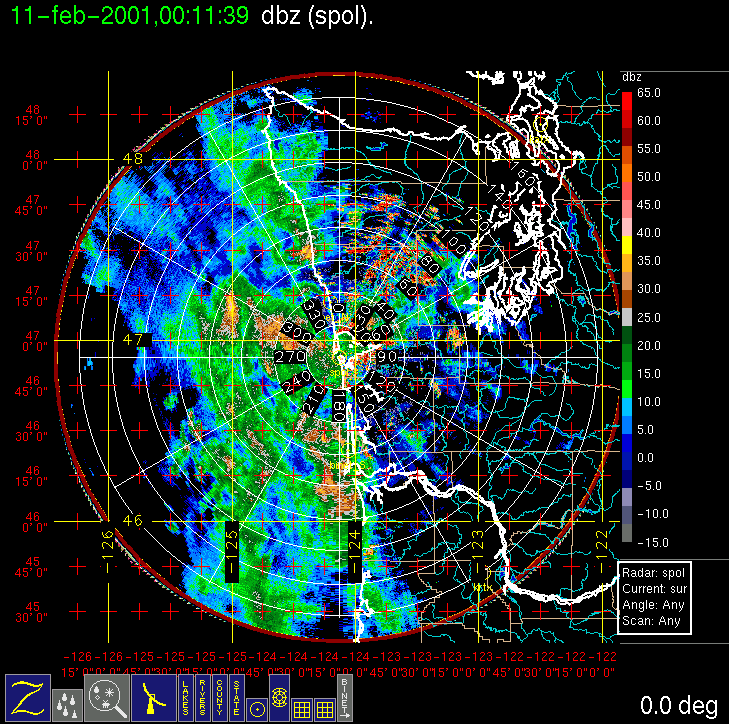
On (Friday) 9 February 2001 the models showed that another surface low-pressure center was forecast to develop in northwesterly flow and pass through the study area on (Saturday) February 10. We called for a research flight of the Convair-580 with a doors closed time of 7 am local time on Saturday morning, with the possibility of two flights. What appeared to be yet another occluded frontal system entered the study area early Saturday morning, a bit faster than the previous model run had indicated, prompting a hastening of the aircraft take-off to 6:30 am local time. The morning flight probed the main precipitation band that entered the study area, although immediately east of the main band, a more convective band also developed (the left and right bands, respectively, between 60 and 100 km range, in this radar image). The convective band, at least for a short time, was a distinctly separate and deeper band [compare the left (convective) and right (main precipitation) bands in this RHI image.] The convective band also represented a significant kinematic feature, with front to rear flow (outbound yellow and brown Doppler velocities) approaching the band at low levels and then ascending over its leading edge, suggesting a squall line or narrow cold-frontal rainband type circulation. The main precipitation band eventually merged with the convective band, becoming a single strong band of precipitation. In one of its passes through the convective band, the Convair-580 was struck by lightning, temporarily knocking out some of the instruments (and draining the blood from the faces of some of the first-time passengers!). The convective band was avoided from that point on. The flight continued without incident, probing the main precipitation band with several legs at 2000-ft intervals from the surface to 20,000 ft. The aircraft landed at Hoquiam and then (in UW Flight 1860) returned to the same precipitation band and studied it during its weakening stage.
Convair-580 Summary
UW Flight Number:
1859 (First flight for this IOP)
Period of Flight:
1430-2005 UTC, 10 february 2001
Main Accomplishments of Flight:
Measurements from 2,000-20,000 ft in wide cold-frontal (?) rainband.
Instrument Problems:
Electrical discharge to aircraft at 1703 UTC caused permanent failure of Johnson-Williams liquid water meter and temporary failure of SPEC CPI.
Flight Scientist:
Peter Hobbs
Approximate UTC Timeline (Local time = UTC – 8 hours) Activity for UW Flight 1859:
1430 Engines on.
1437 Take off from Paine Field.
1437-1447 freezing level at ~2,200 ft. Climb to 9,500 ft (–14 deg C)
1500-1507 Descend to 2,000 ft near Washington coast.
1507-1540 Head to west point (47 deg 10'/125 deg 56') at 2,000 ft. Some precipitation.
1540-1543 Turn at west point.
1543-1612 Head east at –2 deg C level in cloud. Turn back west to 47 deg 11'/125 deg 37', climb to 4,500 ft.
1617-1633 Head west at 4,500 ft (–6 deg C).
1633-1636 Turn.
1636-1642 Head east, climbing to 6,500 ft.
1642-1645 Turn.
1645-1654 Head west at 6,500 ft (–8 deg C).
1654-1656 Turn.
1656-1708 Head east climbing to 8,500 ft.
170310 Electrical discharge from aircraft. Lost CPI temporarily and Johnson-Williams liquid water meter permanently.
1708 Turn at easterly point.
1710-1720 Head west at 8,500 ft. (–13 deg C).
1720-1723 Turn.
1723-1731 Head east climbing to 10,500 ft.
1731-1732 Turn.
1732-1739 Head west at 10,500 ft (–16 deg C).
1739-1749 Turn and head east climbing to 13,500 ft (–22 deg C).
1749-1750 Turn at easterly point.
1750-1759 Head west at 13,500 ft.
1800 Turn.
1802-1809 Head east climbing to 16,500 ft.
1809-1817 Head west at 16,500 ft (–30 deg C).
1817-1819 Turn.
1819-1824 Head east climbing to 19,500 ft (–38 deg C). Breaking out of top of band clouds to east.
1824-1826 (?) Turn.
1826 (?)-1834? Head west at 19,500 ft.
1834 (?) Turn and climb.
1942-1903 Head east to Westport at 20,700 ft (–40 deg C).
1905-1945 Spiral descent on coast at 500 ft/min then 1,000 ft/min to 2,000 ft ahead of rainband but in "interesting precipitation" (S-Pol operator).
~2000 Land at Hoquiam.
UW Flight Number:
1860 (Second flight for this IOP)
Period of Flight:
2148-0225 UTC, 10-11 February 2001
Main Accomplishments of Flight:
Continued to sample same (almost stationary) rainband as on UW Flight 1859.
Instrument Problems:
Some poor images on SPEC CPI. Could not switch 35 GHz radar from up to down at low temperatures.
Flight Scientist:
Peter Hobbs
Approximate UTC Timeline (Local time = UTC – 8 hours) Activity for UW Flight 1860:
2148 Engines on.
2153 Take off from Hoquiam.
2153-2213 Head west to 47 deg 15'/125 deg 02' at 7,000 ft.
2215-2232 Head east at 1,500 ft (1 deg C).
2233 Turn at easterly point.
2134-? Head west climbing at 300 ft/min to 3,500 ft to 47 deg 15'/125 deg 02'.
?-2258 Head east at 3,500 ft (–2.5 deg C).
2300-? Head west climbing to 5,500 ft.
2310 Turn.
2313-2327 Head east at 5,500 ft (–6 deg C).
2327-2329 Turn.
2330-2341 Head west climbing to 8,500 ft.
2341 Turn.
2345-2358 Head east at 8,500 ft (–12 deg C).
2358-0002 Turn.
0002-0013 Head west climbing to 10,500 ft.
0014-0016 Turn.
0017-0026 Head east at 10,500 ft. (–15 deg C).
0026-0029 Turn.
0030-0039 Head west climbing to 13,500 ft.
0040-0055 Headed south to (wrong) coordinate from radar. Returned to original west point location.
0056-0108 Head east at 13,500 ft (–22 deg C). Cirrus fallstreaks.
0108-0111 Turn.
0111-0121 Head west climbing to 16,500 ft (–29 deg C).
0122-0139 Sampled cirrus near westerly point at 18,000 ft (–33 deg C). This cirrus was seeding lower cloud earlier in flight but had drifted to north.
0139 Head back to Paine Field.
0222 Land at Paine Field.
0225 Engines off.
S-Pol Radar Summary
0400 UTC Sat 10 Feb.:
Radar switched from dual-pol to long-range mode.
Scan cycle switched from NWS-Surveillance to Long Range.
1452 UTC Sat 10 Feb.:
Radar switched from long-range to dual-pol mode.
Scan cycle switched from Long Range to Research.
0921 UTC Sun 11 Feb.:
Scan cycle switched from Research to NWS-Surveillance.
Summary of Navy Sonde Launches from Westport
Launch times:
1149 UTC Sat 10 Feb.
1449 UTC Sat 10 Feb.
1746 UTC Sat 10 Feb.
2050 UTC Sat 10 Feb.
2349 UTC Sat 10 Feb.
Note: All sondes launched successfully.
Summary of NWS Sonde Launches from Quillayute (UIL) and Salem (SLE)
Launches are generally started ~1 h before a standard 3-hourly synoptic time, so some sondes are reported as occurring 1 h before the standard synoptic hour.
UIL Launch Times:
1200 UTC Sat 10 Feb. (standard)
1400 UTC Sat 10 Feb. (special)
1800 UTC Sat 10 Feb. (special)
2000 UTC Sat 10 Feb. (special)
0000 UTC Sun 11 Feb. (standard)
0200 UTC Sun 11 Feb. (special)
SLE Launch Times:
1100 UTC Sat 10 Feb. (standard)
1400 UTC Sat 10 Feb. (special)
1800 UTC Sat 10 Feb. (special)
2000 UTC Sat 10 Feb. (special)
0000 UTC Sun 11 Feb. (standard)
0200 UTC Sun 11 Feb. (special)
Note: A miscommunication resulted in no sonde launch at 0600 UTC Sun 11 Feb. at either UIL or SLE.


IMPROVE (University of Washington)