IOP 4: 13 January 2001
Time Period of IOP
1800 UTC 12 Jan 2001- 0000 UTC 14 Jan 2001
Overview of IOP
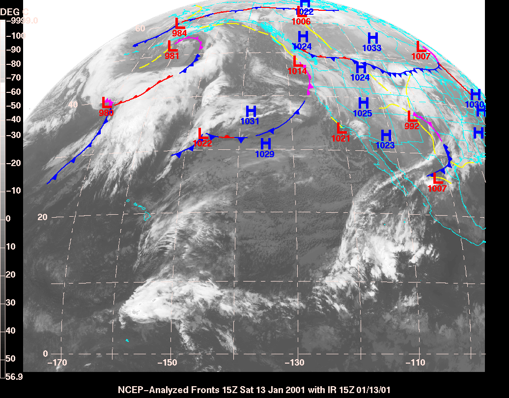
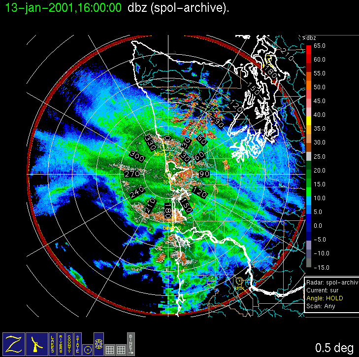
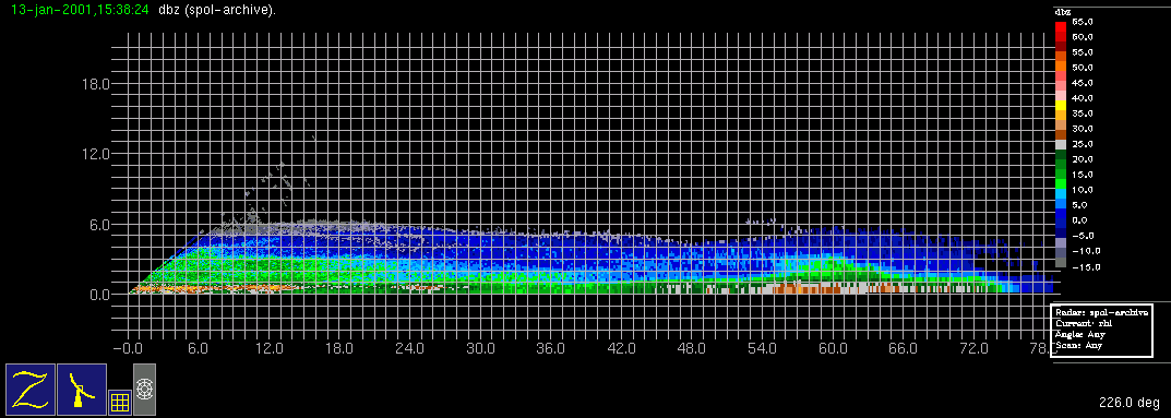
A system was forecast in the study area for (Friday/Saturday) 12-13 January. Initially, a Friday evening Convair-580 flight was planned to capture the approaching warm-frontal precipitation, but it was canceled on Friday afternoon due to the lateness and weakness of the warm-frontal precipitation. A cold or occluded frontal band was forecast in the study area for early Saturday morning, and another flight was planned with a door closed time of 8 am local time on Saturday, but on Friday evening this was moved up to 7 am local time Saturday. The radar console was operated overnight to monitor the onshore progression of the precipitation system. On Saturday, S-Pol radar imagery indicated a rainband was already in the study area at ~4 am local time. However, the rainband nearly stopped its onshore movement, allowing the Convair-580 to capture it with the planned 7 am doors closed time. During the flight, the cloud band associated with the precipitation system took on an S-shape and rotated cyclonically, approximately centered over the radar, but the rainband (see surveillance and RHI radar images) weakened significantly to about 25-30 dBZ maximum echo during the flight. The Convair-580 completed a full stack of horizontal legs up to 23,000 ft. By the end of the flight the band was oriented nearly east-west (initially it had been NW-SE). The flight path, which is normally along an S-Pol radial, was moved northward, with a northeast endpoint just offshore of the North Binet/PNNL site, allowing for several aircraft passes over that site.
Convair-580 Summary
UW Flight Number:
1850
Period of Flight:
1503-2050 UTC, 13 January 2001
Main Accomplishments of Flight:
Measurements in well defined but weak cold or warm-frontal rainband. Good measurements over Olympic Mountains on return and descent to Paine Field.
Instrument Problems:
No recording of 35 GHz radar data.
Flight Scientist:
Peter Hobbs
Approximate UTC Timeline (Local time = UTC – 8 hours) Activity for UW Flight 1850:
1514 Take off from Paine Field
1542 At point A (46 deg 54'/124 deg 06')
1542-1602 A to B at 4,000 ft.
1602-1633 B (46 deg 26'/124 deg 50') to C (47 deg 12'/124 deg 12') at 3,000 ft (North BINET and PNNL site).
1633-1637 Climb to 5,000 ft over C.
1637-1656 C to B at 5,000 ft. Breaking out of cloud near B.
1656-1702 Climb to 7,000 ft at B in clear air.
1702-1721 B to C at 7,000 ft then descend to 6,500 ft to get in cloud. Climb over C to get in cloud.
1721-1725 Climb to 9,000 ft over C.
1725-1742 C to B at 9,000 ft (–12 deg C)
1742-1747 Climb to 11,000 ft over B (about –15 deg C over B at 11,000 ft).
1747-1804 B to C at 11,000 ft.
1804-1806 Climb to 13,000 ft over C.
1806-1825 C to B at 13,000 ft.
1825-1831 Climb to 15,000 ft over B.
1831-1849 B to C at 15,000 ft.
1849-1856 Climb to 20,000 ft over C.
1856-1910 C to B at 20,000 ft. Thin cirrus above, sampling crystals from cirrus above falling into main cloud deck just below.
1910-1917 Climb to 23,000 ft over B.
1917-1933 B to C at 23,000 ft near tops of cirrus.
1933-1953 Descent from 20,000 to 400 ft over C. (Rainband now between S-Pol radar and point C and oriented east-west.)
1953-2000 From C to southwest at 400 ft, then 1,400 ft looking for precipitation (only a few drops).
2000-~2040 Return to Paine Field via Olympics-good cloud and precipitation.
2050 Engines off.
S-Pol Radar Summary
Scan cycle switched from NWS-Surveillance to Long Range
(with RHIs after 0110 UTC).
0530 UTC Sat 13 Jan:
Scan cycle switched from Long Range to Research.
2100 UTC Sat 13 Jan:
Summary of Navy Sonde Launches from Westport
1509 UTC Sat 13 Jan
1802 UTC Sat 13 Jan
2115 UTC Sat 13 Jan
Note: Test launch of Loran sonde with PNNL system at 0115 UTC Sat 12 Jan was unsuccessful for unknown reason.
Summary of NWS Sonde Launches From Quillayute (UIL) and Salem (SLE)
UIL Launch Times:
0000 UTC Sun 14 Jan (standard)
SLE Launch Times:
1200 UTC Sat 13 Jan (standard)
0000 UTC Sun n 14 Jan (standard)
Notes: Special sondes not requested in time for this IOP.


IMPROVE (University of Washington)