| Can you tell us a bit about DEEPAWAVE and all of the organizations that are involved? |
![]() DEEPWAVE is an atmospheric science research project studying the dynamics of gravity waves from the surface of the Earth to the upper reaches of the atmosphere. DEEPWAVE is funded by the National Science Foundation (NSF), Office of Naval Research, and Naval Research Laboratory (NRL), and operated by the National Center for Atmospheric Research (NCAR), in collaboration with the German Aerospace Center DLR, NIWA, UK Met Office, NZ MetService, NRL, and Australian Antarctic Division. The project is led by Principal Investigators from several US universities and research centers as well as international colleagues from New Zealand, Germany, Australia, and the UK. DEEPWAVE aircraft operations will be based in Christchurch, with six ground-sites on the South Island and one in Wellington from June-July 2014.
DEEPWAVE is an atmospheric science research project studying the dynamics of gravity waves from the surface of the Earth to the upper reaches of the atmosphere. DEEPWAVE is funded by the National Science Foundation (NSF), Office of Naval Research, and Naval Research Laboratory (NRL), and operated by the National Center for Atmospheric Research (NCAR), in collaboration with the German Aerospace Center DLR, NIWA, UK Met Office, NZ MetService, NRL, and Australian Antarctic Division. The project is led by Principal Investigators from several US universities and research centers as well as international colleagues from New Zealand, Germany, Australia, and the UK. DEEPWAVE aircraft operations will be based in Christchurch, with six ground-sites on the South Island and one in Wellington from June-July 2014.
| Gravity waves are not a commonly discussed term, can you explain what they are how might they be recognized? |
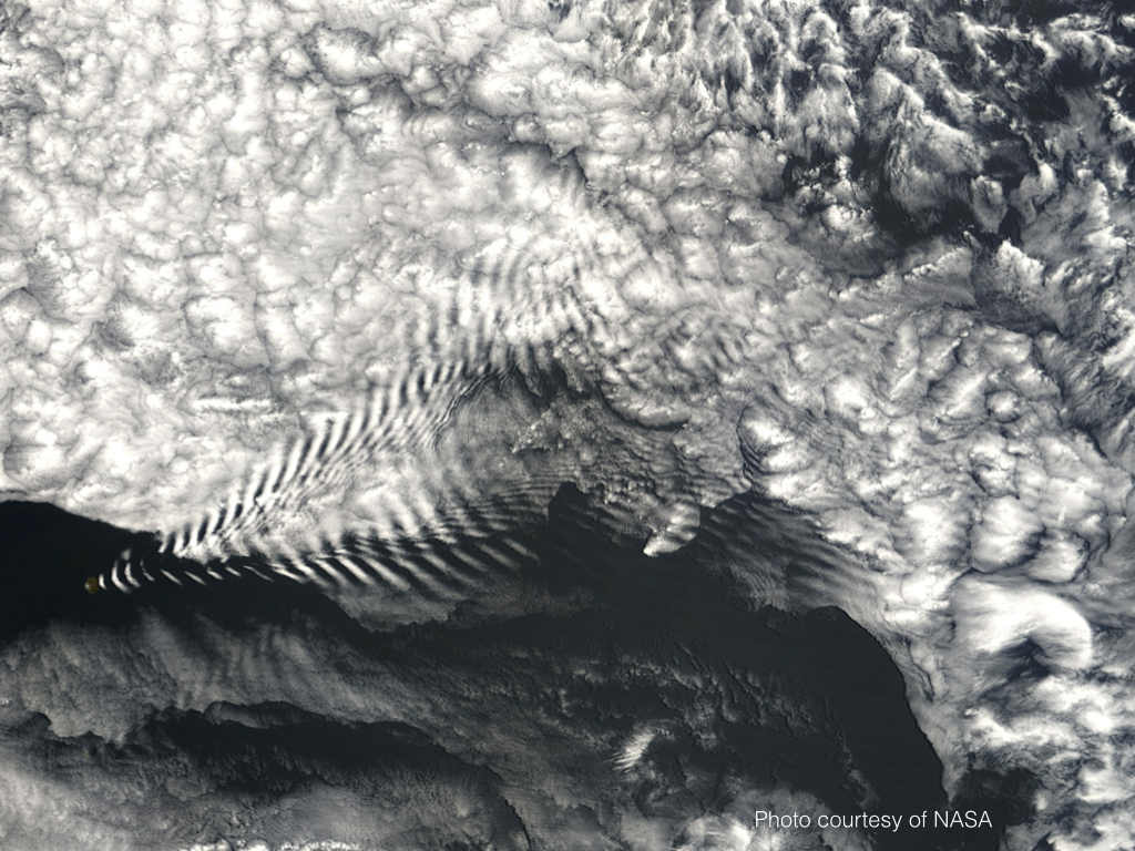 A gravity wave is a disturbance in which buoyancy acts as the restoring force on parcels displaced from hydrostatic equilibrium. Waves on the ocean are examples of gravity waves, they can also be seen as ripples in clouds. Gravity waves are widely recognized to play central roles in a broad range of thermal, chemical, and physical processes extending upward from Earth’s surface to the upper atmosphere.
Recently, the term gravitational waves has been in the news in reference to the Big Bang Theory. They are very different from the gravity waves that we are studying. A gravitational wave is disturbance in space and time over a universal scale, whereas a gravity wave is disturbance on a planetary scale.
| How do gravity waves develop vertically in the atmosphere? |
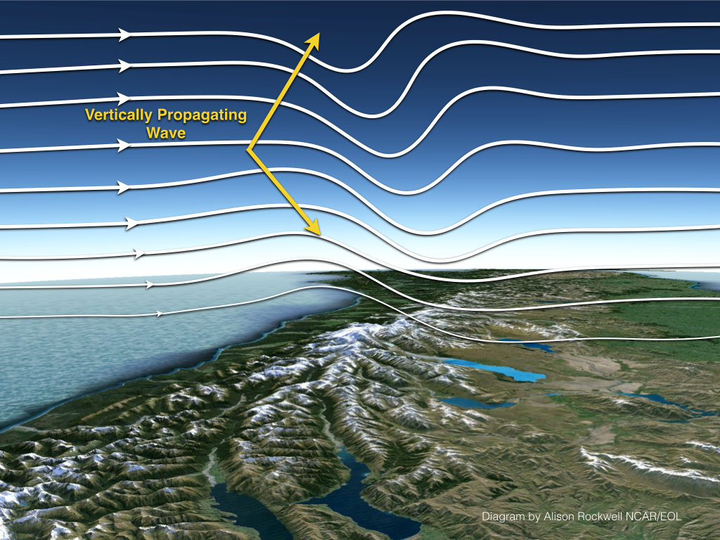
The gravity waves that are being studied during DEEPWAVE begin in the lower layers of the atmosphere after they encounter a trigger such as a mountain range or thunderstorm updraft, which gives rise to their vertical motion. It is this upward transport of energy and momentum, and the range of interactions that cause them to play important roles at all altitudes, also affecting regional weather and global climate.
| How do the gravity waves that you are studying in New Zealand influence weather and climate around the world? |
Gravity waves are generated by many sources around the planet. The major sources include airflow over mountains, deep convection, jet streams, and frontal systems. Gravity waves can propagate to higher altitudes, depending on atmospheric winds, and they have large impacts on the atmospheric circulation that influence weather and climate prediction. Studying gravity wave generation, propagation, and effects at higher altitudes over New Zealand allows us to examine responses to several sources that occur in many places, but which are especially easy to characterize in this region. Understanding gained by studies of gravity waves over New Zealand and the Southern Ocean will guide our descriptions of their effects in weather and climate models across the planet.
| What makes New Zealand a unique location to study gravity waves? |
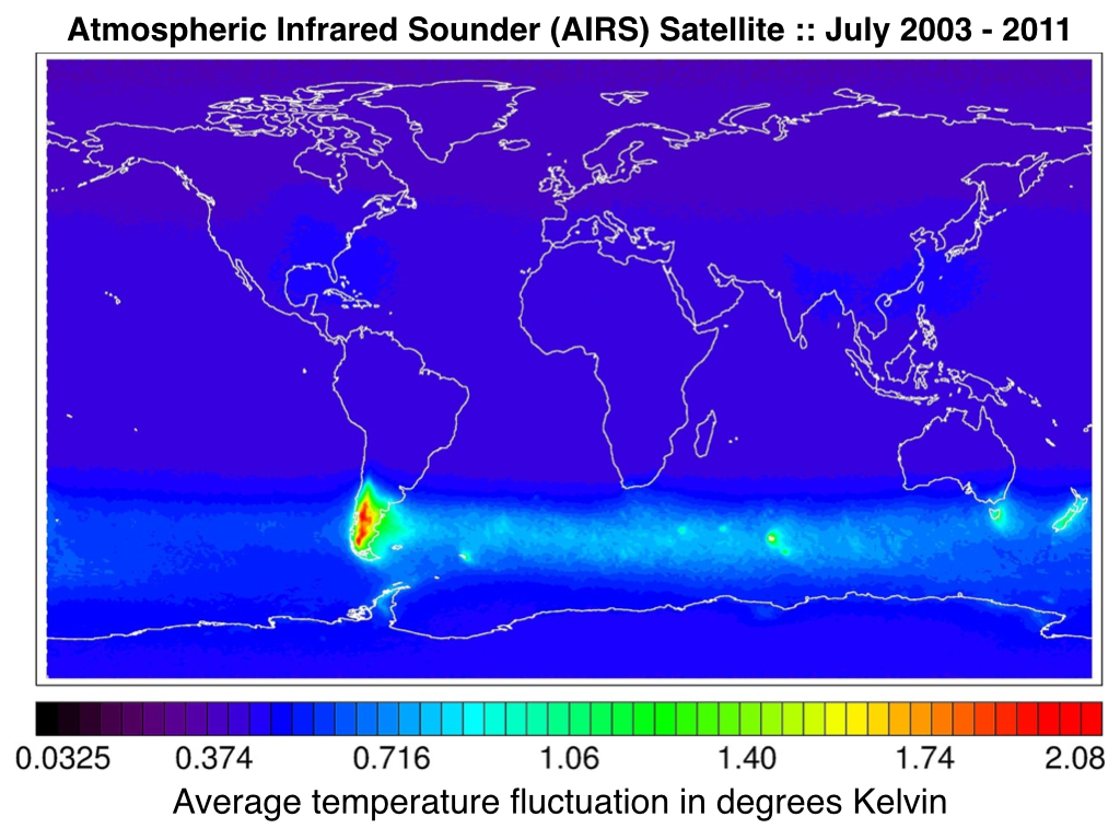 The southern hemisphere is an excellent laboratory for the project due to its reliable and consistent westerly wind circulation patterns. The Southern Alps, a mountain range creating one of the gravity wave “hotspots” in the Southern Hemisphere, is key to the research of the project. The seasonal positioning of the Southern Circumpolar Jet over the mountainous topography allows for the development of strong gravity waves.
The "hotspots" seen in satellite temperature fluctuations are the result of gravity waves at the observation altitudes that have enhanced associated temperature fluctuations due to their oscillatory vertical motions relative to other locations. Gravity waves (and their temperature fluctuations) have horizontal wavelengths varying from as little as 10 or 20 km to hundreds of km or more. Interestingly, it is believed that the gravity waves at smaller horizontal wavelengths are nevertheless the major contributors to variability in atmospheric structure and circulation. We believe that the DEEPWAVE focus on one such hotspot will help us understand more general gravity wave effects at all locations that will contribute to improved weather and climate prediction in the future.
| The NSF/NCAR HIAPER research aircraft is going to be used for research flights, does it have any specialized instrumentation on it to make observations high into the atmosphere? |
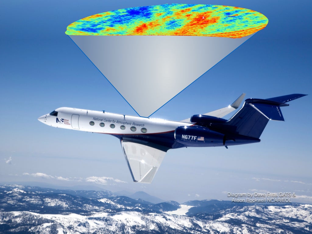
DEEPWAVE will take advantage of new measurement capabilities for the NSF/NCAR HIAPER research aircraft to address a problem of high scientific interest and relevance to weather and climate prediction. The new instruments include two new lidars developed by GATS and an advanced mesosphere temperature mapper (AMTM) developed at Utah State University.
A new-generation sodium resonance lidar will measure vertical winds and temperatures from ~15 to 30 km and from ~80 to 100 km using both pulsed and scanning beams. A high-power UV laser will also measure densities and temperatures from ~30 to 60 km. These lidars will define gravity waves in a vertical plane along HIAPER's flight track.
The AMTM is also a new technology that will allow imaging of gravity wave structures using airglow emissions at ~87 km to map the horizontal structures and propagation of gravity waves in a swath extending ~80 km across the flight track and ~140 km along track. Additional side-viewing airglow cameras will extend gravity wave measurements in airglow brightness at 87 km to ~1200 km across HIAPER's flight track.
| Why do all of the reasearch flights take place at night? |
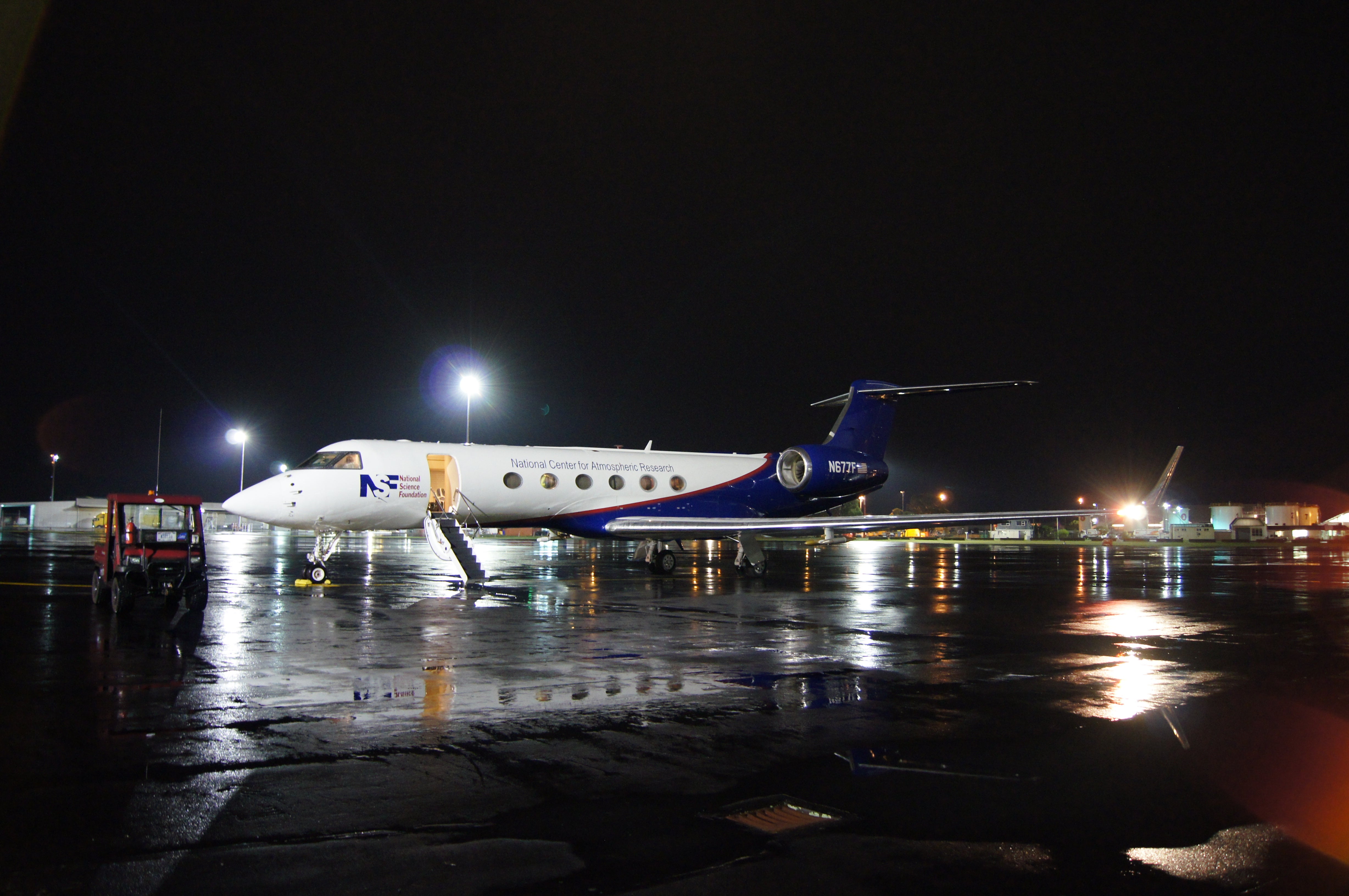 Two of the airplane optical instruments require night operations for the same reason that astronomers operate at night: sunlight is stronger than the faint light signals in the upper atmosphere we are trying to measure.
The Advanced Mesospheric Temperature Mapper (AMTM) is a camera that measures the light from the faint chemical reaction involving the OH molecule in the upper atmosphere. This light is very faint (much weaker than the aurora) and cannot be detected in the daytime when the sunlight swamps the signal.
The Rayleigh and sodium lidars (laser radars) send up about 10W of laser light. This is much less than a normal 50W light bulb, but its direction and color of the laser light can be carefully controlled. A small fraction of the laser bounces off air molecules in the stratosphere and sodium atoms in the upper mesosphere which we collect in a telescope. We time when individual photons return to tell what height we are measuring, similar to how radars work. It is much easier to see the light from our beam at night and this lidar is currently designed only for nighttime operation. It would be possible to add a very narrow color filter to the lidar to let it run in the daytime, but the data would still be ten times worse than nighttime.
| How is this project benefiting society? |
 The data collected during this study will play a vital role in increasing computer modeling and forecasting capabilities of weather events and changes in climate across the globe. This study will allow researchers to gain a better understanding of the effects that gravity waves have on the atmosphere, and in particular weather and climate events affecting people and the environments around them.
Measurements taken at the ground sites are integrated with aircraft and satellite data to provide a complete vertical profile of the atmosphere from the ground up to about 100 km, ultimately providing highly detailed data for enhanced numerical model predictions.