IMPROVE-1
Improvement of Microphysical Parameterization through Observational Verification Experiment
The goals of the offshore field project IMPROVE-1 (Improvement of Microphysical PaRameterization through Observational Verification Experiment-1) was to isolate the errors in the microphysical scheme by obtaining simultaneous ground-based radar, ground-released rawinsondes, and airborne microphysical measurements of precipitation within those portions of cyclones in which moisture and vertical air velocity should be accurately modeled by the MM5 mesoscale model. Past research in the Pacific Northwest carried out in the CYCLES project, and experience gained from analyzing daily runs of the MM5 model, indicated that portions of cyclones that were suitable in this respect included:
- widespread, continuous precipitation ahead of a warm front;
- mesoscale rainbands ahead of a warm front;
- wide cold-frontal rainbands that develop 10-100 km behind a surface cold front; and
- mesoscale rainbands associated with a cold front aloft in occluded frontal systems. Advanced data assimilation techniques will be used to force the MM5 model to accurately model the moisture and vertical air velocity fields in this situation.
Since the goal of the frontal study was to isolate frontal dynamics as the precipitation generating mechanism, a region was sought that had a uniform lower boundary in terms of topography, roughness, moisture availability, and surface temperature; was sufficiently far (a Rossby radius) from significant topography; and experiences a high frequency of wintertime frontal precipitation events.
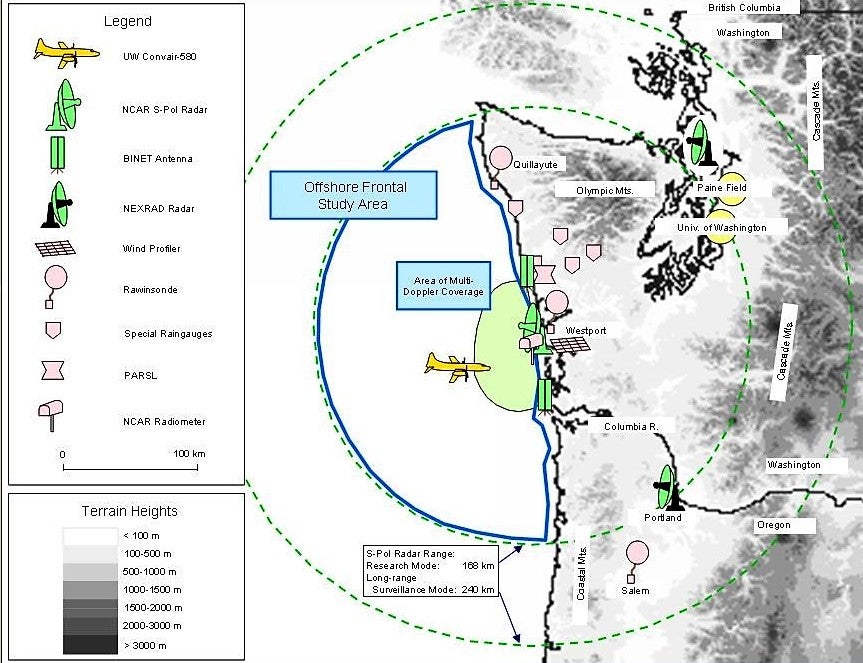
The time of year (4 January -- 14 February 2001) and location, satisfying these requirements, was the northeastern Pacific Ocean off the Washington Coast (see map) in winter. This area exhibits a relatively uniform sea-surface temperature distribution (compared to storm tracks in the western parts of the Atlantic and Pacific Oceans), and it experiences a high frequency of cyclonic storms and frontal passages from November through February. The advantage of focusing on this particular section of coast is that there is a large gap in the Coastal Mountains. Thus, most of the region within the study area exceeds a Rossby radius from the Olympic and Coastal Mountains.
The University of Washington (UW) Department of Atmospheric Sciences in Seattle was the Forecasting and Operations Control Center (FOCC) for IMPROVE-1. Between Intensive Observing Periods (IOPs), the NCAR S-Pol radar on the Washington Coast was used for surveillance of incoming storms, and this radar imagery was available to forecasters at the FOCC. When forecasts indicated that a frontal system was approaching within ~200 km of the Washington Coast, 3-hourly launches of rawinsondes were commenced at Quillayute, Westport, and Salem stations.
 |
PROJECT OPERATIONS
The Convair-580 departed from its home base at Paine Field, Washington, when the S-Pol radar showed precipitation features of interest within ~1 hour of being ~170 km from the coast. The Convair-580 was guided into precipitation features of interest off the Washington Coast by air-to-ground communications with a scientist at the FOCC who had real-time displays of the S-Pol radar images with the location of the Convair-580 overlaid. The basic flight pattern was a vertical profile from close to the ocean surface to the top of the cloud system or to the maximum altitude of the Convair-580 (~7.25 km), with the aircraft generally advecting with the precipitating feature of interest as it moved onto the coast through the region of dual-Doppler coverage.
 |
OBSERVATIONS/DATA
Measurements were collected in eleven (11) IOPs during IMPROVE-1. The IOPs covered primarily occluding systems and some weak cold fronts. Within these systems, detailed vertical airborne profiles and Doppler radar measurements were obtained in warm-frontal, warm-sector, pre-occlusion, pre-cold frontal, cold-frontal, and wide cold-frontal rainbands. To see a complete list of IOPS, please visit the University of Washington's Improve-1 IOP Menu.
| Aircraft | UW Convair-580 |
|---|---|
| Model | NOAA Aviation Forecast (AVN) Model output (model runs initialized every 6 h, with forecast data every 3 h out to 60 h) |
| Model | NOAA Eta Forecast Model output (model runs initialized every 6 h, with forecast data every 3 h out to 60 h) |
| Model | UW Mesoscale Model (MM5) output (MMOUT files only for domains 2 and 3, hrs 12-24, every 3 h. Imagery for all three domains, 3-h out to 60 h) |
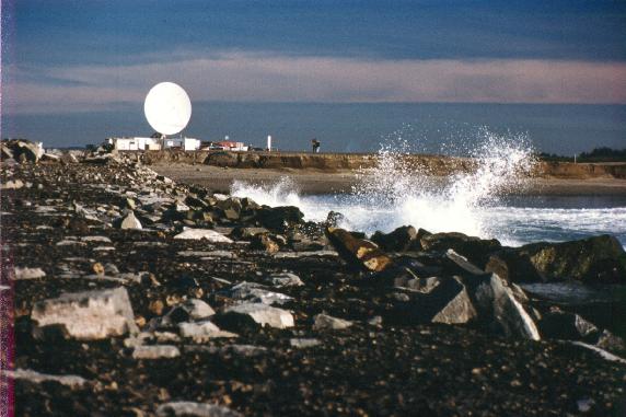
| Radar | NCAR S-band dual-polarized (S-Pol) at Westport, WA |
| Radar | NCAR bistatic receiver network (BINET) to gather dual Doppler velocity data |
| Radar | NWS NEXRAD Radars at Seattle, WA (KATX), Portland, OR (KRTX), Medford, OR (KMAX), Spokane, WA (KOTX), and Pendleton, OR (KPDT) |
| Radiometer | NCAR Scanning Microwave Radiometer at the S-Pol radar site (Westport, WA) |
| Radiometer | Pacific Northwest National Laboratory (PNNL) Remote Sensing Laboratory (PARSL). Site included: included a 94-GHz cloud radar, surface meteorology and accumulated precipitation, a suite of radiometers (broadband, infrared, rotating multifilter shadowbands, total sky imager, microwave radiometer, and ceilometer |
| Profiler | NOAA/ETL Profiler Site (Westport, WA). Site included: a 915-MHz Wind Profiler, a Radio-Acoustic Sounding System (RASS), and surface meteorology |
| Satellite | GOES-10 Imagery (1-km, 4-km, and 8-km Visible; 4-km and 8-km IR; and 4-km and 8-km Water Vapor) |
| Surface | UW Rainguage Network (five sites on the western Olympic Peninsula) |
| Surface | METAR worldwide surface weather reports |
| Upper Air | UW Special Rawinsonde Station (Westport, WA). 3-h frequency during IOPs |
| Upper Air | NWS rawinsonde at Quillayute, WA and Salem, OR. Normal 00 and 12 UTC releases plus 3-h intervals during IOPs. |
Data Manager:
- Bob Rilling NCAR/EOL
- EOL Archive, NCAR/EOL/DMS