Search
Overview
A Scientific Project in the Indian Ocean to Understand Global Climate & Weather Systems
![]() As the global climate changes, it becomes more urgent to understand how the oceans and atmosphere work together to regulate the Earth-s temperature and respond to long-term variation. The study of climate aims to quantify the degree of global temperature changes and their consequences, such as sea-level rise, with increasing detail. This information can be used by national/local governments and society to plan mitigation and adaptation strategies. Such quantitative information requires detailed knowledge of the structures and evolution of the atmosphere and ocean in the tropics.
As the global climate changes, it becomes more urgent to understand how the oceans and atmosphere work together to regulate the Earth-s temperature and respond to long-term variation. The study of climate aims to quantify the degree of global temperature changes and their consequences, such as sea-level rise, with increasing detail. This information can be used by national/local governments and society to plan mitigation and adaptation strategies. Such quantitative information requires detailed knowledge of the structures and evolution of the atmosphere and ocean in the tropics.
From 1 October 2011-31 March 2012, a group of meteorologists, oceanographers, and climate scientists from 13 countries will gather in the equatorial Indian Ocean for a major scientific project to observe the development of the Madden-Julian Oscillation (MJO) at its source. This project is called DYNAMO, which stands for Dynamics of the Madden-Julian Oscillation.
What is the Madden-Julian Oscillation?
"The Madden-Julian Oscillation is the bridge between weather and climate".
- Chidong Zhang, Chief Scientist
The Indian Ocean is one of the Earth-s most sensitive regions where ocean and atmosphere interact, affecting the global climate. What happens here sends impulses out over much of the globe via a phenomenon called the Madden-Julian Oscillation, or MJO.
The MJO is a 30 to 90 day tropical weather cycle that starts over the equatorial Indian Ocean and moves eastward into the western Pacific, alternating between large, strong rain storms and relatively quiet periods, covering a large region of several thousands of kilometer across. The region over the Indian Ocean where the MJO initiates typically has cooler sea surface temperatures, and as the system progresses, it moves eastward into the warmer waters of the western Pacific Ocean. Cloud systems then build up due to heat and readily available moisture from the ocean. The convective storm systems moving through the equatorial regions have reverberating effects on weather to both the Northern and Southern Hemispheres.
The environmental factors of the initiation of this weather cycle is of great interest to scientists, as the MJO has far reaching impacts on both the global climate and weather. Collecting data that will in turn be studied and entered into climate models, will "drastically improve our confidence in climate models", says DYNAMO Chief Scientist Chidong Zhang.
Collaborative Research
The project is funded by the following U.S. agencies:
- NSF :: National Science Foundation
- DOE :: Department of Energy
- ONR :: Office of Naval Research
- NOAA :: National Oceanic and Atmospheric Administration
- NASA :: National Aeronautics and Space Administration
DYNAMO Hypotheses
The following hypotheses will be tested using DYNAMO field observations, auxiliary data (from moorings, satellites, and global reanalyses), and numerical models constrained, validated and evaluated by observations.
Hypothesis I: Deep convection can be organized into an MJO convective envelope only when the moist layer has become sufficiently deep over a region of the MJO scale; the pace at which this moistening occurs determines the duration of the pre-onset stage.
Hypothesis II: Specific convective populations at different stages are essential for MJO initiation.
Hypothesis III: The barrier-layer, wind- and shear-driven mixing, shallow thermocline, and mixing-layer entrainment all play essential roles in MJO initiation in the Indian Ocean by controlling the upper-ocean heat content and SST, and thereby surface flux feedback.


Publication or Paper Examining Tropical Cyclone - Kelvin Wave Interactions using Adjoint Diagnostics
DOI Guidance to Authors
The National Center for Atmospheric Research Earth Observing Laboratory uses Digital Object Identifiers (DOIs) to promote attribution of EOL-hosted Lower Atmospheric Observing Facilities (LAOF) and datasets. We do so to recognize the work and creativity of dataset authors, follow modern data citation practices, obtain reliable metrics, and implement reproducible research practices.
This document provides guidance for authors on citing EOL LAOF and datasets both within the body of a publication, and well as in the references section. These guidelines take guidance from the Harvard citation style and other sources referenced at the end of this document. If you are submitting your publication to a journal, please be sure to follow their required guidelines.
Accessing Datasets and Citing a Dataset in the Reference Section of a Publication
Within the EOL data archive, each dataset landing page (homepage) contains a link to order/download the data.

Figure 1. Example EOL dataset landing page
When you order data, a "readme" file will be added to your data order containing dataset metadata and a cut-and-paste citation. The sample citation is also always available near the bottom of the dataset homepage:
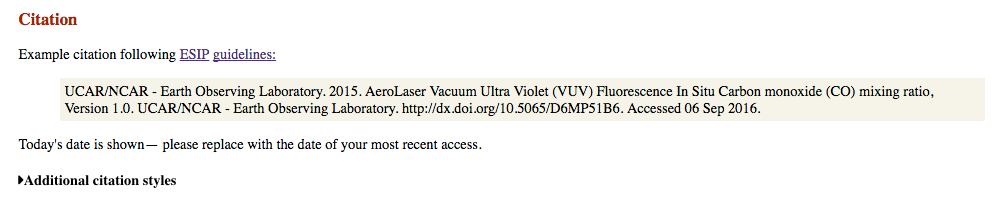
Figure 2. Example dataset citation
This example citation can be used in the references section of a document:
UCAR/NCAR - Earth Observing Laboratory. 2015. AeroLaser Vacuum Ultra Violet (VUV) Fluorescence In Site Carbon monoxide (CO) mixing ratio, Version 1.0. UCAR/NCAR - Earth Observing Laboratory. EamAccessed 01 Sep 2016.
The citation also includes a link to reformat the citation to meet the requirements of many common journals. Click on “Additional Citation Styles” to open a new page section. Select the journal you are submitting to, and the page will auto-generate a cut-and-paste citation specific to that journal. This feature depends on the external CrossCite service and so may not always be functional. It is an automatic metadata formatting procedure and may need cleanup or fine-tuning to be usable. Please review the provided citation against journal requirements.
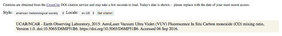
Figure 3. Additional citation styles dropdown
Citations include a version number. If a dataset landing page does not list the needed version as the current version, please email the primary point of contact listed on the page, explaining why access to the data is needed (such as for reproducibility) and we will provide the needed data. As the current version is the version that should be used for all research publications, previous versions are not available online. This is to avoid confusion and accidental publication of the wrong data.
If only a subset of the dataset is used, this can be indicated in the example citation as follows:
UCAR/NCAR - Earth Observing Laboratory. 2015. AeroLaser Vacuum Ultra Violet (VUV) Fluorescence In Site Carbon monoxide (CO) mixing ratio, Version 1.0. Subset used: Flight RF01 UCAR/NCAR - Earth Observing Laboratory. https://doi.org/10.5065/D6MP51B6. Accessed 01 Sep 2016.
The above citation does NOT include the field project name. It is given on the dataset landing page and within the DOI metadata. If citing data from multiple field projects for a single instrument, the user may wish to explicitly specify the field project name in the dataset title.
Citing a Dataset in the Body of a Publication
To cite an EOL dataset in the text of a publication, spell out the full organizational name in the text immediately before the citation or within the parenthetical citation the first time the source is cited, followed by the organizational abbreviation in brackets. Use only the abbreviation in subsequent citations. When citing multiple EOL datasets collected during the same year, append lowercase letters to the year to distinguish the different datasets in the reference list.
Example
“The NSF/NCAR Gulfstream V collected Low Rate (1sps) Navigation, State Parameter, and Microphysical data (UCAR/NCAR - Earth Observing Laboratory [EOL] 2016a) which was used in this study. In addition, digital camera imagery (EOL 2016b) was used for situational awareness.”
Citing an EOL LAOF in the Reference Section
Cut-and-paste citations for the physical object (platform/instruments) DOI and first-use paper (where extant) are included at the bottom of the physical object landing pages. Here is the NSF/NCAR C-130 Research Aircraft citation:
|
Citation When referencing the NSF/NCAR Hercules C130 Aircraft in publications or proposals, please use the identifier doi:10.5065/D6WM1BG0 -- for example as a citation: UCAR/NCAR - Earth Observing Laboratory, 1994-present. NSF/NCAR Hercules C-130 Aircraft. UCAR/NCAR - Earth Observing Laboratory. https://doi.org/10.5065/D6WM1BG0 Accessed July-August 2016 Please be careful of line breaks when cutting and pasting the above text, and feel free to reformat to fit your document. Additional citation styles are available at DataCite or CrossCite. |
Figure 4. Example LAOF citation
DOIs have been assigned for the following LAOF. Please note that we are in the process of getting the citations onto the bottom of all landing pages and should have this complete by 30 September, 2016. If a page doesn’t show a citation, please contact us for information.
Table 1. List of LAOF [* NCAR/EOL HIAPER Airborne Instrumentation Solicitation (HAIS) Instruments (14 total)]
| Instrument's Full Name | Acronym | DOI |
| Advanced Whole Air Samples* | AWAS | https://doi.org/10.5065/D65X270F |
| Airborne Vertical Atmospheric Profiling System | AVAPS | https://doi.org/10.5065/D66W9848 |
| Autonomous Airborne Ozone Photometer* | OP-1, OP-2 | https://doi.org/10.5065/D6154F36 |
| Automatic Giant Nuclei Impactor | Auto-GNI | https://doi.org/10.26023/r267-m386 |
| Field catalog | N/A | https://doi.org/10.5065/D6SQ8XFB |
| Giant Nuclei Impactor | GNI | https://doi.org/10.26023/3nza-5670 |
| Georgia Tech Chemical Ionization Mass Spectrometer* | GT CIMS | https://doi.org/10.5065/D6XD0ZQF |
| GNSS Instrument System for Multistatic and Occultation Sensing* | GISMOS | https://doi.org/10.5065/D6J67F00 |
| GPS Advanced Upper-air Sounding System | GAUS | https://doi.org/10.5065/D6TM785S |
| HIAPER Airborne Radiation Package* | HARP | https://doi.org/10.5065/D6FF3QDN |
| HIAPER Cloud Radar | HCR | https://doi.org/10.5065/D6BP00TP |
| High Spectral Resolution Lidar* | HSRL | https://doi.org/10.5065/D67W6976 |
| Integrated Sounding System | ISS | https://doi.org/10.5065/D6348HF9 |
| Integrated Surface Flux System | ISFS | https://doi.org/10.5065/D6ZC80XJ |
| MicroPulse Differential Absorption Lidar | MPD | https://doi.org/10.5065/d6st7nkg |
| Microwave Temperature Profiler* | MTP | https://doi.org/10.5065/D6251G7K |
| Nitric Oxide Chemiluminescence Ozone Instrument* | FO3_ACD, FO3 | https://doi.org/10.5065/D6SN070H |
| NSF/NCAR Gulfstream V High-performance Instrumented Airborne Platform for Environmental Research | GV HIAPER | https://doi.org/10.5065/D6DR2SJP |
| NSF/NCAR Hercules C-130 | C-130 | https://doi.org/10.5065/D6WM1BG0 |
| Quantum Cascade Laser Spectrometer* | QCLS | https://doi.org/10.5065/D69P2ZQC |
| S-band/Ka-band Dual Polarization, Dual Wavelength Doppler Radar | S-PolKa | https://doi.org/10.5065/D6RV0KR8 |
| Small Ice Detector Version 2 for HIAPER* | SID2H, SID-II | https://doi.org/10.5065/D6K35RQN |
| Three-View Cloud Particle Imager* | 3V-CPI | https://doi.org/10.5065/D6NV9G9P |
| Time-of-Flight Aerosol Mass Spectrometer* | ToF-AMS | https://doi.org/10.5065/D64X55VN |
| Trace Organic Gas Analyzer* | TOGA | https://doi.org/10.5065/D6DF6P9Q |
| Vertical Cavity Surface-Emitting Laser Hygrometer* | VCSEL | https://doi.org/10.5065/D6PV6HDM |
| University of Wyoming Cloud Lidar | WCR | https://doi.org/10.15786/m25w9d |
| University of Wyoming Cloud Radar | WCL | https://doi.org/10.15786/m2237s |
Citing an EOL LAOF in the Body of a Publication
Facilities (platforms and instruments) should be cited in the text the same way as datasets, e.g. (EOL 2016). See the section on Citing a Dataset in the text above for details.
Requesting to have a DOI assigned to a Dataset
To cite a dataset that does not currently have a DOI, please email eol-datahelp@ucar.edu and include a link to the dataset landing page. EOL staff will work with the dataset PI to get a DOI assigned and notify you when it is ready.
Citing Software and Data Workflows
EOL is in the process of developing guidelines for citing software and workflows. As that work is completed, guidance will be included here. In the meantime, please email eol-archive@ucar.edu and we will work with you to get what you need. In addition, the American Astronomical Society has some guidelines on citing software that may be informative.
References
The following document provided guidance in the development of these guidelines:
AMS, 2016: Data Archiving and Citation 23 June 2016 American Meteorological Society, accessed 2 September 2016 [Available online at https://www.ametsoc.org/ams/index.cfm/publications/authors/journal-and-bams-authors/journal-and-bams-authors-guide/data-archiving-and-citation/]

Related Links
MATERHORN-X Dry Run Operations Plan
MATERHORN Overview Presentation (2015)
MATERHORN Contacts & Collaborators
MATERHORN Timeline

Meetings and Presentations
MATERHORN-X Dry Run Operations Plan
MATERHORN Overview Presentation (2015)
MATERHORN Contacts & Collaborators
MATERHORN Timeline