1. Why is it critical that we understand the initiation processes of the Madden-Julian Oscillation?
DYNAMO will provide researchers with vital observations of the Madden-Julian Oscillation (MJO), a poorly understood phenomena, particularly the initiation phase. The results will help researchers to more accurately forecast the weather and climate of the equatorial Indian Ocean and around the world. Large-scale weather events, such as the MJO, create pulses that have direct effects on regional weather patterns around the world, similar to that of a chain reaction.
Gaining a better understanding of the environmental factors during developmental stages of the MJO will vastly increase our understanding of global climate systems and enable researchers to produce more accurate climate models. With these added benefits, scientists can better predict future changes to our climate.
2. How is the MJO a "bridge" between weather and climate?
A MJO event is characterized as a period of enhanced tropical rain storms, with intervals of little to no rainfall, creating regional weather patterns in the Indian and Pacific Oceans. The 30-90 day weather cycle usually then becomes nondescript as it moves beyond the region. The size and scale of this regional weather pattern causes direct effects on other weather, as well as climate patterns around the globe.
Like a row of dominos, one falls over causing a chain reaction of others to follow suit, a MJO weather event can have a chain reaction of other response, some large enough to affect climate.
"With a greater understanding of the initiation process of the MJO, improvement in weather prediction can be gained on one hand while improving the seasonal predictions of climate variability on the other hand" states Chidong Zhang, DYNAMO Chief Scientist.
3. How will this study of the initiation of the MJO benefit climate modeling?
|
"The data collected during DYNAMO will improve our confidence in climate models", says Zhang. |
The large amounts of observational data collected during DYNAMO will provide researchers with an unprecedented data set that will be incorporated into climate models. These empirical data provide information such as the physical properties of clouds; cloud population and evolution; general atmospheric attributes; wind speeds and direction; amount of energy being absorbed and emitted by the Earth; and a host of ocean conditions.
This abundance of new data from a previously poorly-understood phenomena, will be incorporated into different climate models to help better predict regional weather and global climate variabilities.
4. What other global climate patterns are associated with the MJO?
The MJO has far reaching effects on many other global climate patterns such as the El Niño-Southern Oscillation (ENSO), Northern Hemisphere monsoons, tropical storm development, and even pineapple express events. Having a better understanding and prediction capability of the initiation phase of the MJO would have direct benefits to communities all over the globe.
- ENSO :: The MJO shows variability from year to year of periods of strong activity to periods of weaker activity. Past observations have shown strong periods of MJO activity about 6-12 months prior to the onset of the El Niño-Southern Oscillation (ENSO) event, a global climate pattern, demonstrating a direct connection between the MJO and global climate patterns. The fishing industry is directly affected by this climate pattern.
- Asian Monsoons :: MJO events have an tendency to move in a northeasterly direction when they develop, which in turn impact the monsoon rainfall over Asia. Environmental conditions associated with the MJO impact the enhanced period of intense rain and periods of suppressed drought-causing conditions over the Asian continent (Yasunari 1979; Annamalai and Slingo 2001). Improved MJO prediction and modeling would have beneficial impacts on industries such as agriculture, natural resource management, and human health in one of the world's most populated regions.
- Tropical Storm Development :: Evidence has been shown that tropical storms, both in the Pacific and Atlantic basins, react to favorable or unfavorable, large-scale environmental conditions - such as sea surface temperature and wind patterns - that the MJO provides. Communities affected by tropical storms would have more time to prepare for storms with better prediction capabilities and modeling of the MJO.
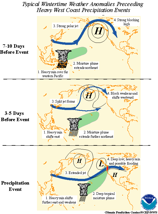
- Pineapple Express Events :: The term "Pineapple Express" is derived from an influx of warm, moist tropical air into the Pacific Northwest regions of the United States, usually accompanied by heavy rainfall. The warm, wet air masses are typically associated with an eastwardly moving MJO event moving from the western Pacific to eastern Pacific Ocean. The high pressure system involved with the MJO weather disturbance forces the strong global pattern of wind, also called the jet stream, to shift northward creating pressure differences on either side of it. The resulting weather events are heavy rain storms in North America's northwest and west coast regions.
5. Six months is longer than the average field project, why does DYNAMO need to collect data for this amount of time?

- A 5-day running mean of the MJO
through October 1, 2006.
Image courtesy of NOAA
Click to enlarge
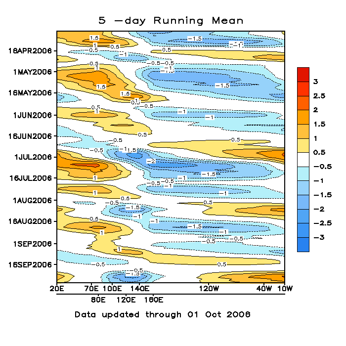
The MJO is a 30-90 day weather pattern that moves eastwardly across the the Indian Ocean region, typically during the fall and winter months of the Northern Hemisphere. In order to increase the chances that at least one, ideally more, target weather oscillation will pass over the large study area, a longer time frame increases the probability of being able to successfully observe an entire initiation process of the Madden-Julian Oscillation.
This Hovmöller diagram shows the time on the y-axis and longitude on the x-axis, showing the intensity of an MJO event over a seven month period in 2006.

