Search
COMET Case Study 019: Oklahoma City Tornado
Project Dates
May 3, 1999 to May 4, 1999
Project Location
Oklahoma/Kansas
Project Description
Case 019 focuses on the severe convective event that affected much of northern and central Oklahoma and south central Kansas. Tornados in Oklahoma and Kansas resulted in 48 deaths and several hundred injuries
Objectives
This case provides data from these deadly tornados to allow more in depth study of the event.
- COMET Case Study 001: The Storm of the Century
- COMET Case Study 012: Gravity Waves
- COMET Case Study 016: Moberly Missouri Tornado
- COMET Case Study 014: Midwest Cold Season Synoptic Storm
- COMET Case Study 017: Desert SW Severe Weather
- COMET Case Study 013: S. California Floods/Florida Tornadoes
- COMET Case Study 038: Birmingham Tornado
- COMET Case Study 015: Southeast U.S. Cyclogenesis
- COMET Case Study 018: Spencer Tornado and Minn -> NY Derecho
- COMET Case Study 022: Northeastern US Severe Weather
- COMET Case Study 039: Iowa Bow Echo
- COMET Case Study 041: Southern California Severe Weather
- COMET Case Study 040: Kansas City Flash Flood
- COMET Case Study 035: San Antonio Flood
- COMET Case Study 021: Wichita, Kansas Halloween Flood
- COMET Case Study 023: Winter Severe Weather
- COMET Case Study 027: Southern Louisiana Tornados
- COMET Case Study 019: Oklahoma City Tornado
- COMET Case Study 025: Salt Lake City Tornado/Long Island Flood
- COMET Case Study 020: Hurricane Floyd
- COMET Case Study 029: Montana Fire Weather-Dry Cold Front
- COMET Case Study 026: Pacific Northwest Winter Storm
- COMET Case Study 024: East Coast Explosive Cyclogenesis
- COMET Case Study 030: Null Event: Eastern Colorado Snowstorm
- COMET Case Study 028: Fort Worth Tornado
- COMET Case Study 031: Null Event: Central Plains Severe Wx
- COMET Case Study 033: Missouri Isolated Severe Weather
- COMET Case Study 034: New Jersey Flood: Terrain Locked Convect
- COMET Case Study 032: Buffalo Lake Effect Snowstorm
- COMET Case Study 036: Seattle Snowstorm
- COMET Case Study 037: Tropical Storm Allison
- COMET Case Study 042: Kansas Winter Storm
- COMET Case Study 043: Colorado Fire/Kansas Severe Weather
- COMET Case Study 044: November 10th Tornadoes 2002
COMET Case Study 025: Salt Lake City Tornado/Long Island Flood
Project Dates
August 11, 1999 to August 12, 1999
Project Description
Case 025 represents one of the most devastating weather events in Utah's history. On August 11th 1999 a tornado moved through downtown Salt Lake City between 18:45 and 18:55 UTC. The tornado damage was rated as F2 on the Fujita scale, and was resonsible for the first recorded tornado death in the state's history and dozens of injuries. Hail up to 1.5 inches in diameter was also reported from this storm. In addition, on the East Coast, flash floods impacted Long Island. Between 13Z and 17Z on August 11, clusters of thunderstorms formed along a warm front. As they moved very slowly east, they produced heavy rain that caused flash flooding from Deer Park to Manorville, NY. Rainfall rates estimated at 1 to 2 inches per hour for up to 3 hours generated rainfall totals from 3 to 5 inches. Water, rapidly accumulating in low-lying areas, swept cars away and trapped people in their vehicles.
Objectives
The case allows the study of severe weather in mountain regions, and also the study of convective flash flooding on the East Coast.
- COMET Case Study 001: The Storm of the Century
- COMET Case Study 012: Gravity Waves
- COMET Case Study 016: Moberly Missouri Tornado
- COMET Case Study 014: Midwest Cold Season Synoptic Storm
- COMET Case Study 017: Desert SW Severe Weather
- COMET Case Study 013: S. California Floods/Florida Tornadoes
- COMET Case Study 038: Birmingham Tornado
- COMET Case Study 015: Southeast U.S. Cyclogenesis
- COMET Case Study 018: Spencer Tornado and Minn -> NY Derecho
- COMET Case Study 022: Northeastern US Severe Weather
- COMET Case Study 039: Iowa Bow Echo
- COMET Case Study 041: Southern California Severe Weather
- COMET Case Study 040: Kansas City Flash Flood
- COMET Case Study 035: San Antonio Flood
- COMET Case Study 021: Wichita, Kansas Halloween Flood
- COMET Case Study 023: Winter Severe Weather
- COMET Case Study 027: Southern Louisiana Tornados
- COMET Case Study 019: Oklahoma City Tornado
- COMET Case Study 025: Salt Lake City Tornado/Long Island Flood
- COMET Case Study 020: Hurricane Floyd
- COMET Case Study 029: Montana Fire Weather-Dry Cold Front
- COMET Case Study 026: Pacific Northwest Winter Storm
- COMET Case Study 024: East Coast Explosive Cyclogenesis
- COMET Case Study 030: Null Event: Eastern Colorado Snowstorm
- COMET Case Study 028: Fort Worth Tornado
- COMET Case Study 031: Null Event: Central Plains Severe Wx
- COMET Case Study 033: Missouri Isolated Severe Weather
- COMET Case Study 034: New Jersey Flood: Terrain Locked Convect
- COMET Case Study 032: Buffalo Lake Effect Snowstorm
- COMET Case Study 036: Seattle Snowstorm
- COMET Case Study 037: Tropical Storm Allison
- COMET Case Study 042: Kansas Winter Storm
- COMET Case Study 043: Colorado Fire/Kansas Severe Weather
- COMET Case Study 044: November 10th Tornadoes 2002
COMET Case Study 020: Hurricane Floyd
Project Dates
September 14, 1999 to September 17, 1999
Project Description
Case 020 provides focus on Hurricane Floyd which brought heavy rain and flooding to the eastern coast of the United States and was responsible for 68 deaths and $2.5 billion in damages.
Objectives
This case provides data to allow in depth study of Hurricane Floyd.
- COMET Case Study 001: The Storm of the Century
- COMET Case Study 012: Gravity Waves
- COMET Case Study 016: Moberly Missouri Tornado
- COMET Case Study 014: Midwest Cold Season Synoptic Storm
- COMET Case Study 017: Desert SW Severe Weather
- COMET Case Study 013: S. California Floods/Florida Tornadoes
- COMET Case Study 038: Birmingham Tornado
- COMET Case Study 015: Southeast U.S. Cyclogenesis
- COMET Case Study 018: Spencer Tornado and Minn -> NY Derecho
- COMET Case Study 022: Northeastern US Severe Weather
- COMET Case Study 039: Iowa Bow Echo
- COMET Case Study 041: Southern California Severe Weather
- COMET Case Study 040: Kansas City Flash Flood
- COMET Case Study 035: San Antonio Flood
- COMET Case Study 021: Wichita, Kansas Halloween Flood
- COMET Case Study 023: Winter Severe Weather
- COMET Case Study 027: Southern Louisiana Tornados
- COMET Case Study 019: Oklahoma City Tornado
- COMET Case Study 025: Salt Lake City Tornado/Long Island Flood
- COMET Case Study 020: Hurricane Floyd
- COMET Case Study 029: Montana Fire Weather-Dry Cold Front
- COMET Case Study 026: Pacific Northwest Winter Storm
- COMET Case Study 024: East Coast Explosive Cyclogenesis
- COMET Case Study 030: Null Event: Eastern Colorado Snowstorm
- COMET Case Study 028: Fort Worth Tornado
- COMET Case Study 031: Null Event: Central Plains Severe Wx
- COMET Case Study 033: Missouri Isolated Severe Weather
- COMET Case Study 034: New Jersey Flood: Terrain Locked Convect
- COMET Case Study 032: Buffalo Lake Effect Snowstorm
- COMET Case Study 036: Seattle Snowstorm
- COMET Case Study 037: Tropical Storm Allison
- COMET Case Study 042: Kansas Winter Storm
- COMET Case Study 043: Colorado Fire/Kansas Severe Weather
- COMET Case Study 044: November 10th Tornadoes 2002
COMET Case Study 029: Montana Fire Weather-Dry Cold Front
Project Dates
October 30, 1999 to November 1, 1999
Project Description
A dry cold front passed through eastern Montana on 31 October 1999 bringing in a strong northwest wind behind it. Warmer and drier than normal conditions existed in the region at this time, so with the addition of strong wind, the fire danger rose greatly. Sustained winds of 50+ knots and gusts to near 80 knots were reported in eastern Montana, driving fires near the towns of Outlook and Wolf Point. Over $12 million in damages are estimated statewide from the strong wind and fires.
Objectives
This case expands the coverage of our Case Study Library to Fire Weather events, and allows in-depth study of fire weather mechanisms associated with a dry cold front acoss Montana.
- COMET Case Study 001: The Storm of the Century
- COMET Case Study 012: Gravity Waves
- COMET Case Study 016: Moberly Missouri Tornado
- COMET Case Study 014: Midwest Cold Season Synoptic Storm
- COMET Case Study 017: Desert SW Severe Weather
- COMET Case Study 013: S. California Floods/Florida Tornadoes
- COMET Case Study 038: Birmingham Tornado
- COMET Case Study 015: Southeast U.S. Cyclogenesis
- COMET Case Study 018: Spencer Tornado and Minn -> NY Derecho
- COMET Case Study 022: Northeastern US Severe Weather
- COMET Case Study 039: Iowa Bow Echo
- COMET Case Study 041: Southern California Severe Weather
- COMET Case Study 040: Kansas City Flash Flood
- COMET Case Study 035: San Antonio Flood
- COMET Case Study 021: Wichita, Kansas Halloween Flood
- COMET Case Study 023: Winter Severe Weather
- COMET Case Study 027: Southern Louisiana Tornados
- COMET Case Study 019: Oklahoma City Tornado
- COMET Case Study 025: Salt Lake City Tornado/Long Island Flood
- COMET Case Study 020: Hurricane Floyd
- COMET Case Study 029: Montana Fire Weather-Dry Cold Front
- COMET Case Study 026: Pacific Northwest Winter Storm
- COMET Case Study 024: East Coast Explosive Cyclogenesis
- COMET Case Study 030: Null Event: Eastern Colorado Snowstorm
- COMET Case Study 028: Fort Worth Tornado
- COMET Case Study 031: Null Event: Central Plains Severe Wx
- COMET Case Study 033: Missouri Isolated Severe Weather
- COMET Case Study 034: New Jersey Flood: Terrain Locked Convect
- COMET Case Study 032: Buffalo Lake Effect Snowstorm
- COMET Case Study 036: Seattle Snowstorm
- COMET Case Study 037: Tropical Storm Allison
- COMET Case Study 042: Kansas Winter Storm
- COMET Case Study 043: Colorado Fire/Kansas Severe Weather
- COMET Case Study 044: November 10th Tornadoes 2002
COMET Case Study 026: Pacific Northwest Winter Storm
Project Dates
November 23, 1999 to November 26, 1999
Project Description
Case 026 follows an early winter storm moving onshore in thePacific Northwest on November 24, 1999. The storm brought heavy precipitation, while the associated cold front brought strong winds to the coasts of Oregon and Washington. The north Oregon coastline reported high winds November 24, as Conon Beach reported wind of 55-60 knots with gusts to 69 knots, while Arch Cape also reported gusts to 69 knots. The northern Oregon coast reported up to 10 inches of rain, causing flodding and landslides.
Objectives
The case provides an example of a winter storm in the Pacific Northwest, and allows study of storm/precipitation formation in complex terrain under zonal flow.
- COMET Case Study 001: The Storm of the Century
- COMET Case Study 012: Gravity Waves
- COMET Case Study 016: Moberly Missouri Tornado
- COMET Case Study 014: Midwest Cold Season Synoptic Storm
- COMET Case Study 017: Desert SW Severe Weather
- COMET Case Study 013: S. California Floods/Florida Tornadoes
- COMET Case Study 038: Birmingham Tornado
- COMET Case Study 015: Southeast U.S. Cyclogenesis
- COMET Case Study 018: Spencer Tornado and Minn -> NY Derecho
- COMET Case Study 022: Northeastern US Severe Weather
- COMET Case Study 039: Iowa Bow Echo
- COMET Case Study 041: Southern California Severe Weather
- COMET Case Study 040: Kansas City Flash Flood
- COMET Case Study 035: San Antonio Flood
- COMET Case Study 021: Wichita, Kansas Halloween Flood
- COMET Case Study 023: Winter Severe Weather
- COMET Case Study 027: Southern Louisiana Tornados
- COMET Case Study 019: Oklahoma City Tornado
- COMET Case Study 025: Salt Lake City Tornado/Long Island Flood
- COMET Case Study 020: Hurricane Floyd
- COMET Case Study 029: Montana Fire Weather-Dry Cold Front
- COMET Case Study 026: Pacific Northwest Winter Storm
- COMET Case Study 024: East Coast Explosive Cyclogenesis
- COMET Case Study 030: Null Event: Eastern Colorado Snowstorm
- COMET Case Study 028: Fort Worth Tornado
- COMET Case Study 031: Null Event: Central Plains Severe Wx
- COMET Case Study 033: Missouri Isolated Severe Weather
- COMET Case Study 034: New Jersey Flood: Terrain Locked Convect
- COMET Case Study 032: Buffalo Lake Effect Snowstorm
- COMET Case Study 036: Seattle Snowstorm
- COMET Case Study 037: Tropical Storm Allison
- COMET Case Study 042: Kansas Winter Storm
- COMET Case Study 043: Colorado Fire/Kansas Severe Weather
- COMET Case Study 044: November 10th Tornadoes 2002
COMET Case Study 024: East Coast Explosive Cyclogenesis
Project Dates
January 19, 2000 to January 26, 2000
Project Description
Case 024 follows the formation and rapid intensification of a cyclone off of the southeastern U.S. coastline. The storm moved almost due north, affecting nearly the entire eastern seaboard. In retrospect, this storm's intensity and position was difficult for the models to predict accurately, posing a forecasting challenge for NWS offices in the affected region. Heavy snow fell from the Carolinas, through the Washington D.C. area, and into New England, with at least 5 deaths reported. Record snowfall amounts fell across North Carolina, with the Raleigh-Durham area most affected.
Objectives
The case provides an example of rapid cyclogenesis off the southeast U.S. coast and its associated Northeaster. The data is being made available for in-depth study due to great interest from the meteorological community.
- COMET Case Study 001: The Storm of the Century
- COMET Case Study 012: Gravity Waves
- COMET Case Study 016: Moberly Missouri Tornado
- COMET Case Study 014: Midwest Cold Season Synoptic Storm
- COMET Case Study 017: Desert SW Severe Weather
- COMET Case Study 013: S. California Floods/Florida Tornadoes
- COMET Case Study 038: Birmingham Tornado
- COMET Case Study 015: Southeast U.S. Cyclogenesis
- COMET Case Study 018: Spencer Tornado and Minn -> NY Derecho
- COMET Case Study 022: Northeastern US Severe Weather
- COMET Case Study 039: Iowa Bow Echo
- COMET Case Study 041: Southern California Severe Weather
- COMET Case Study 040: Kansas City Flash Flood
- COMET Case Study 035: San Antonio Flood
- COMET Case Study 021: Wichita, Kansas Halloween Flood
- COMET Case Study 023: Winter Severe Weather
- COMET Case Study 027: Southern Louisiana Tornados
- COMET Case Study 019: Oklahoma City Tornado
- COMET Case Study 025: Salt Lake City Tornado/Long Island Flood
- COMET Case Study 020: Hurricane Floyd
- COMET Case Study 029: Montana Fire Weather-Dry Cold Front
- COMET Case Study 026: Pacific Northwest Winter Storm
- COMET Case Study 024: East Coast Explosive Cyclogenesis
- COMET Case Study 030: Null Event: Eastern Colorado Snowstorm
- COMET Case Study 028: Fort Worth Tornado
- COMET Case Study 031: Null Event: Central Plains Severe Wx
- COMET Case Study 033: Missouri Isolated Severe Weather
- COMET Case Study 034: New Jersey Flood: Terrain Locked Convect
- COMET Case Study 032: Buffalo Lake Effect Snowstorm
- COMET Case Study 036: Seattle Snowstorm
- COMET Case Study 037: Tropical Storm Allison
- COMET Case Study 042: Kansas Winter Storm
- COMET Case Study 043: Colorado Fire/Kansas Severe Weather
- COMET Case Study 044: November 10th Tornadoes 2002
COMET Case Study 030: Null Event: Eastern Colorado Snowstorm
Project Dates
March 19, 2000 to March 21, 2000
Project Description
This case is the first in a series of null-event cases and presents a developing winter storm in the Desert Southwest and its effect on Eastern Colorado's weather, on 20 March, 2000. Forecasts of over a foot of snowfall by late evening on Monday the 20th of March were issued as early as the afternoon of Sunday the 19th of March, from Denver to Fort Collins. By 10 p.m. Monday, snow reports from most areas along the Front Range were only 3 to 5 inches.
Objectives
This case is an example of a Colorado Front Range snowstorm that was forecast to be much stronger than what actually occurred. It allows study of the conditions necessary to produce heavy snow in Eastern Colorado, and how the models mis-represented the conditions in this case.
- COMET Case Study 001: The Storm of the Century
- COMET Case Study 012: Gravity Waves
- COMET Case Study 016: Moberly Missouri Tornado
- COMET Case Study 014: Midwest Cold Season Synoptic Storm
- COMET Case Study 017: Desert SW Severe Weather
- COMET Case Study 013: S. California Floods/Florida Tornadoes
- COMET Case Study 038: Birmingham Tornado
- COMET Case Study 015: Southeast U.S. Cyclogenesis
- COMET Case Study 018: Spencer Tornado and Minn -> NY Derecho
- COMET Case Study 022: Northeastern US Severe Weather
- COMET Case Study 039: Iowa Bow Echo
- COMET Case Study 041: Southern California Severe Weather
- COMET Case Study 040: Kansas City Flash Flood
- COMET Case Study 035: San Antonio Flood
- COMET Case Study 021: Wichita, Kansas Halloween Flood
- COMET Case Study 023: Winter Severe Weather
- COMET Case Study 027: Southern Louisiana Tornados
- COMET Case Study 019: Oklahoma City Tornado
- COMET Case Study 025: Salt Lake City Tornado/Long Island Flood
- COMET Case Study 020: Hurricane Floyd
- COMET Case Study 029: Montana Fire Weather-Dry Cold Front
- COMET Case Study 026: Pacific Northwest Winter Storm
- COMET Case Study 024: East Coast Explosive Cyclogenesis
- COMET Case Study 030: Null Event: Eastern Colorado Snowstorm
- COMET Case Study 028: Fort Worth Tornado
- COMET Case Study 031: Null Event: Central Plains Severe Wx
- COMET Case Study 033: Missouri Isolated Severe Weather
- COMET Case Study 034: New Jersey Flood: Terrain Locked Convect
- COMET Case Study 032: Buffalo Lake Effect Snowstorm
- COMET Case Study 036: Seattle Snowstorm
- COMET Case Study 037: Tropical Storm Allison
- COMET Case Study 042: Kansas Winter Storm
- COMET Case Study 043: Colorado Fire/Kansas Severe Weather
- COMET Case Study 044: November 10th Tornadoes 2002
Met Station at RICO
| What |
|
|---|---|
| When | Dec 03, 2004 12:00 PM to Jan 05, 2005 12:00 PM |
| Where | Rico |
| Contact Name | Gordon Maclean |
| Contact Phone | (303) 497-8794 |
Introduction
This document describes the operation and measurements of the Integrated Surface Flux Facility (ISFF) meteorological station during RICO.
If you reached this page from a search engine, click here to see the full report, with frames.
RICO Links
Site Description
The GPS coordinates for the site are 17 deg 33.047' N, 61 deg 44.259' W (from the RICO Project Information book).
Schedule
December 3rd, 2004 -Data collection starts
January 25th, 2005 -Data collection ends
Instrumentation
The instrumentation consists of:
- Barometer, Vaisala PTB220B, with a single-disk static pressure port
- Vaisala 50Y Humitters to measure air temperature and RH at 2m AGL in NCAR aspirated radiation shield
- RMYoung Prop Vane at 10 meters
- Long and short wave radiometers
- Rain gauge
Sensor Notes
No major sensor problems occurred during this project.
Propeller-Vanes
No problems occurred. The mast was down on both Dec 30 and 31 to move communications antennae. These data have been removed.
T/RH
The first 5 hours of data collected on Dec 3 were from a bad sensor. The rest of the data were okay. The Gortex filter was replaced approximately weekly (and had some salt build-up). We don't think this should affect the data. The fan also was inspected (at least by ear) almost daily and was always working. The fan was removed from its housing a few times during the project and moisture and crystallized salt was found on the housing, but the blade appeared to be unaffected.
Derived values of specific humidity have been added to the data files.
Barometer
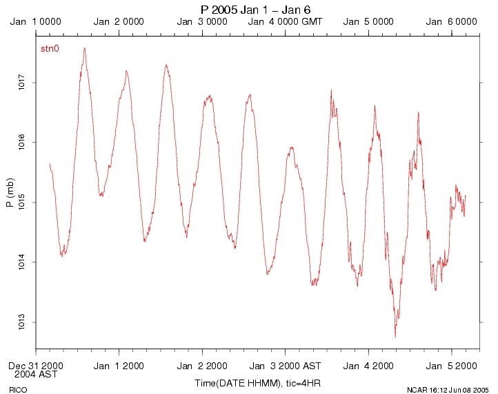
No problems occurred. The pressure signal is dominated by a semidurnal oscillation associated with a solar "tide", typical of tropical conditions (see example).
Radiometers
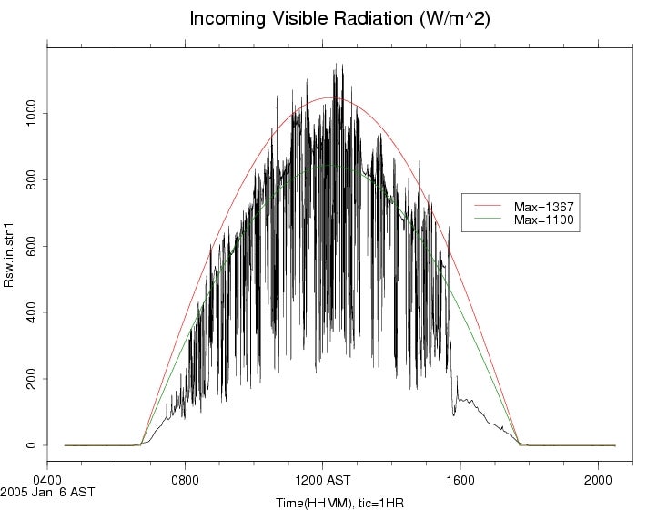
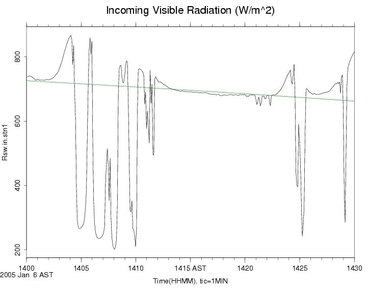
Both the pyranometer and pyrgeometer behaved properly throughout the program. However, persistent winds built up a thin coating of salt spray on the windward (east) side. For this reason, both radiometers were cleaned every day (usually in the morning). Because cloud-free skies almost never happened, it is quite difficult to estimate the error caused by this spray, but it could actually enhance the measured radiation due to increased specular reflections. With the frequent cleanings, we have ignored this error.
Two unusual characteristics in the short-wave data are short-duration spikes, due to shadowing by small (~100m) quickly-moving (15m/s) clouds, and enhancement of radiation above the cosine-weighted attenuated solar constant at the edges of clouds due to direct sunlight collected by the optically-thin clouds. Examples of this are 1 day, a few clouds.
Values of long-wave radiation derived simply as: R_pile + sigma T_case^4 have been added to the data files. This should be sufficient since Kipp-and-Zonen pyrgeometers were used.
Rain Gauge
This operated normally as far as we can tell. Total accumulation was only 40mm, which seems somewhat low and may be due to high winds affecting the collection efficiency. (Though this usually is not a problem for liquid precipitation.) A few test tips on Dec 4 and Dec 29 have been removed from the data set.
Photographs
Photos of the station and environment around Spanish Point are here. Here are Ned Chamberlain's, Mike Susedik's, and Steve Oncley's tourist photos.
Here are unedited STATION PANORMAS taken from on top of the tripod and rotating around the mast:
Set-1
Field Logbook
A computer-readable field logbook of comments by NCAR and other personnel is available in read-only html form.
Data Plots
Click on the above link to plots of 5 minute statistics of the sampled variables.
Data Download
The NCAR data are available for download in the following forms:


Data Policy
Data Set Documentation Guidelines
Data Submission Instructions
Scientific Overview Document (PDF)
Operations Plan (PDF)
Kathy Caesar's Weather Summary (PDF)
Participant Web Pages
UCLA
UCSC
University of Miami:
Overview | Instrumentation
University of Wyoming
Facility Web Pages
COMET Case Study 028: Fort Worth Tornado
Project Dates
March 28, 2000 to March 29, 2000
Project Description
On the evening of 28 March 2000, two tornados struck Fort Worth, Arlington, and Grand Prairie, Texas. The Fort Worth Tornado touched down west of the city, and moved through the downtown area. The tornado was rated an F2 on the Fujita scale at its strongest point. The Arlington tornado started as an F3, and varied from F2 to F0 throughout its 6.5 mile track. The damages from these tornados was estimated at $450 million in the Fort Worth area. 5 F2's, and 8 F0-F1's. While southern Louisiana's annual average for tornados is 13 (1950-1995), it hosted 12 tornados on 1-2 January. All of the tornados were indicated by WSR-88D radars in Lake Charles and Fort Polk, Louisiana. The average lead time was an impressive 24 minutes. There was one fatality in Texas, but, given the severity of the outbreak and the fact that it happened overnight, it is fortunate that there were not more people injured or killed
Objectives
This case provides an example of a Texas severe weather event, and allows an in-depth study of the severe weather mechanisms in the Southern plains and Texas.
- COMET Case Study 001: The Storm of the Century
- COMET Case Study 012: Gravity Waves
- COMET Case Study 016: Moberly Missouri Tornado
- COMET Case Study 014: Midwest Cold Season Synoptic Storm
- COMET Case Study 017: Desert SW Severe Weather
- COMET Case Study 013: S. California Floods/Florida Tornadoes
- COMET Case Study 038: Birmingham Tornado
- COMET Case Study 015: Southeast U.S. Cyclogenesis
- COMET Case Study 018: Spencer Tornado and Minn -> NY Derecho
- COMET Case Study 022: Northeastern US Severe Weather
- COMET Case Study 039: Iowa Bow Echo
- COMET Case Study 041: Southern California Severe Weather
- COMET Case Study 040: Kansas City Flash Flood
- COMET Case Study 035: San Antonio Flood
- COMET Case Study 021: Wichita, Kansas Halloween Flood
- COMET Case Study 023: Winter Severe Weather
- COMET Case Study 027: Southern Louisiana Tornados
- COMET Case Study 019: Oklahoma City Tornado
- COMET Case Study 025: Salt Lake City Tornado/Long Island Flood
- COMET Case Study 020: Hurricane Floyd
- COMET Case Study 029: Montana Fire Weather-Dry Cold Front
- COMET Case Study 026: Pacific Northwest Winter Storm
- COMET Case Study 024: East Coast Explosive Cyclogenesis
- COMET Case Study 030: Null Event: Eastern Colorado Snowstorm
- COMET Case Study 028: Fort Worth Tornado
- COMET Case Study 031: Null Event: Central Plains Severe Wx
- COMET Case Study 033: Missouri Isolated Severe Weather
- COMET Case Study 034: New Jersey Flood: Terrain Locked Convect
- COMET Case Study 032: Buffalo Lake Effect Snowstorm
- COMET Case Study 036: Seattle Snowstorm
- COMET Case Study 037: Tropical Storm Allison
- COMET Case Study 042: Kansas Winter Storm
- COMET Case Study 043: Colorado Fire/Kansas Severe Weather
- COMET Case Study 044: November 10th Tornadoes 2002
COMET Case Study 031: Null Event: Central Plains Severe Wx
Project Dates
April 18, 2000 to April 19, 2000
Project Description
This case is a good example of what happens when the environment is so capped that despite many other favorable conditions, no convection can occur. Early in the day, the models and model soundings showed indications of the potential for severe weather in the Central Plains states. By late in the day, mostly clear skies dominated the region,as the cap prevailed over Kansas, Oklahoma, and north central Texas.
Objectives
This case provides an example of a strongly capped severe weather environment, and shows that despite very favorable instability and shear, no convection can occur.
- COMET Case Study 001: The Storm of the Century
- COMET Case Study 012: Gravity Waves
- COMET Case Study 016: Moberly Missouri Tornado
- COMET Case Study 014: Midwest Cold Season Synoptic Storm
- COMET Case Study 017: Desert SW Severe Weather
- COMET Case Study 013: S. California Floods/Florida Tornadoes
- COMET Case Study 038: Birmingham Tornado
- COMET Case Study 015: Southeast U.S. Cyclogenesis
- COMET Case Study 018: Spencer Tornado and Minn -> NY Derecho
- COMET Case Study 022: Northeastern US Severe Weather
- COMET Case Study 039: Iowa Bow Echo
- COMET Case Study 041: Southern California Severe Weather
- COMET Case Study 040: Kansas City Flash Flood
- COMET Case Study 035: San Antonio Flood
- COMET Case Study 021: Wichita, Kansas Halloween Flood
- COMET Case Study 023: Winter Severe Weather
- COMET Case Study 027: Southern Louisiana Tornados
- COMET Case Study 019: Oklahoma City Tornado
- COMET Case Study 025: Salt Lake City Tornado/Long Island Flood
- COMET Case Study 020: Hurricane Floyd
- COMET Case Study 029: Montana Fire Weather-Dry Cold Front
- COMET Case Study 026: Pacific Northwest Winter Storm
- COMET Case Study 024: East Coast Explosive Cyclogenesis
- COMET Case Study 030: Null Event: Eastern Colorado Snowstorm
- COMET Case Study 028: Fort Worth Tornado
- COMET Case Study 031: Null Event: Central Plains Severe Wx
- COMET Case Study 033: Missouri Isolated Severe Weather
- COMET Case Study 034: New Jersey Flood: Terrain Locked Convect
- COMET Case Study 032: Buffalo Lake Effect Snowstorm
- COMET Case Study 036: Seattle Snowstorm
- COMET Case Study 037: Tropical Storm Allison
- COMET Case Study 042: Kansas Winter Storm
- COMET Case Study 043: Colorado Fire/Kansas Severe Weather
- COMET Case Study 044: November 10th Tornadoes 2002