Search
Introduction
The Multi-Institution Collaborative: Student Experience in Airborne Research in the Mid- Atlantic Region (SEAR-MAR), was an educational field deployment of the University of Wyoming King Air aircraft (UWKA) in the period 4-18 November 2017. The participating universities were Millersville University (MU), Pennsylvania State University (PSU), Rutgers, The State University of New Jersey - Rutgers (RU), and the University of Maryland, Baltimore County (UMBC). Figure 3 shows the location of the four universities in relation to the project domain. The domain outlined in white represents the area within which the Wyoming Cloud Lidar (WCL) could be safely operated, although some missions where the WCL was not essential included transects there were outside this domain.
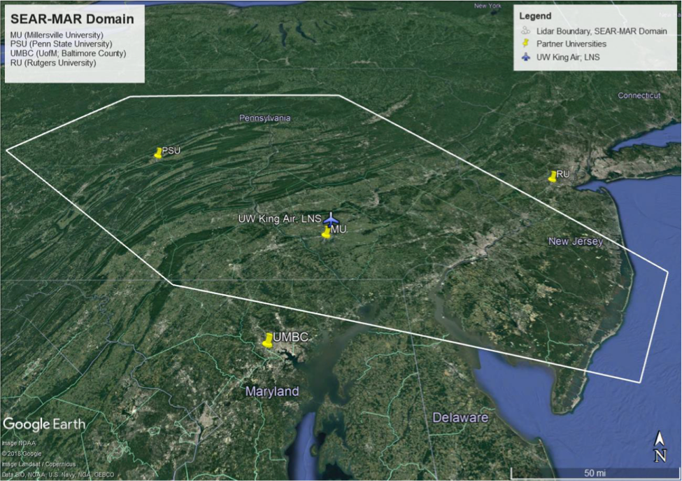
The geographic domain was centered roughly on Lancaster, PA, so it made sense to have the UWKA and Wyoming operations center located at the Lancaster Airport (KLNS), about 12 miles from the Millersville University campus.
As an educational deployment, the purpose of SEAR-MAR provided the locus for undergraduate and graduate student participation in airborne research. The scientific objectives were selected from the atmospheric phenomena that were likely to be observed based on November climatology in the mid-Atlantic region and were experimentally feasible for study by an instrumented airborne platform. While each scientific mission was designed around the use of the UWKA as the primary facility, each of the participating universities contributed their own ground-based and/or upper air instruments for in situ and remote sensing measurements, which further enhanced and expanded the overall capability. In several cases, these additional facilities provided much-needed coupling to the surface. The National Science Foundation (NSF) also provided funding for 90 radiosondes (60 Vaisala® RS41-SGP; 30 Windsonds®). Not only were the students active participants in research using an instrumented research aircraft, they also had rich exposure to the supporting instrumentation provided by the university partners, which afforded them the opportunity to develop competencies in assembling, operating, maintaining, calibrating, and analyzing data from multiple sensors.
The atmospheric phenomena in the mid-Atlantic region that drew our combined interests spanned the synoptic, mesoscale, microscale, atmospheric chemistry, and even aircraft instrument calibration. The table below provides a list of the IOPs dedicated to SEAR-MAR.
| Date | Flight# | Status | Times (UTC) | Hours |
| 17 Nov 2017 | RF14 | Clear air profiling near Rutgers' PAM site and Millersville's ground site. | 1751-1932 | 1.8 |
| 16 Nov 2017 | RF13b | Second of two paired flights, sampling emissions downwind of Philadelphia. | 2113-2254 | 1.8 |
| 16 Nov 2017 | RF13a | First of two paired flights, sampling background emissions upwind of Philadelphia. | 1845-2001 | 1.3 |
| 16 Nov 2017 | RF12 | Sampling boundary layer across coastal transition (UMBC cold-frontal track). | 1349-1601 | 2.3 |
| 15 Nov 2017 | RF11 | Rutgers PAM site overflight & coastal boundary layer sampling. | 1803-2006 | 2.2 |
| 14 Nov 2017 | RF10 | Calibration maneuvers - static pressure profile. | 1750-1854 | 1.1 |
| 11 Nov 2017 | RF09 | Ocean-bay-land boundary layer characterization. | 1245-2004 | 2.5 |
| 11 Nov 2017 | RF08 | Cold Pool and Northerly LLJ | 1209-1514 | 3.1 |
| 10 Nov 2017 | RF07 | Mountain Waves | 1424-1625 | 2.1 |
| 09 Nov 2017 | RF06 | Emissions profiles around Enlow & Cumberland coal mines. | 1759-2150 | 3.9 |
| 08 Nov 2017 | RF05 | Emissions profile, Sugar Run-Salt Springs track. | 1656-2008 | 3.3 |
| 07 Nov 2017 | RF04 | Mid-level frontogenesis. | 1656-2022 | 3.6 |
| 06 Nov 2017 | RF03 | Fine structure of fronts. | 1935-2228 | 3.0 |
| 06 Nov 2017 | RF02 | Fine structure of fronts. | 1400-1753 | 3.9 |
| 04 Nov 2017 | RF01 | Cold air damming flight profile. | 1155-1551 | 4.1 |
In all, SEAR-MAR consisted of 15 research intensive operating periods (IOPs) employing a total of 40 flight hours, and five test flights. Given the breadth of research topics, it should not be surprising that all 40 hours of UWKA flight time allocated to the project were used. Select IOP missions are discussed in section III.
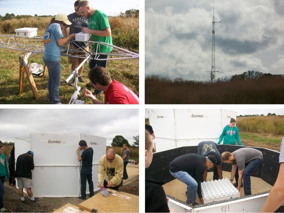
While it was relatively easy to develop a list of interesting and relevant science objectives, recall that the purpose of SEAR-MAR was to provide a conduit for learning by doing. Indeed, SEAR- MAR involved over 100 students from the partner universities, many of whom were able to directly connect their SEAR-MAR involvement to concurrent coursework and/or research. Section IV addresses that outcome in detail. Forty-five students flew on 15 UWKA flights accumulating 40 flight hours over a 12-day deployment. In addition to its standard in situ instrumentation, the UWKA was outfitted with the upward and downward pointing cloud lidar, and a Picarro. Students from MU, PSU, and UMBC launched 60 rawinsondes over the course of SEAR-MAR. Moreover, scores of MU students were directly involved with the transport, assembly, and maintenance of MU’s ground-based instruments, which were deployed at Frey Farm Landfill, which is about 10 km west of MU. Those ground-based instruments included an MFAS SODAR with RASS extension, an MPL-111 SigmaSpace Lidar, and 10 m flux tower with instruments at 2 and 8.5 meters.
In addition to flying on the UWKA and taking lead roles with the other instrument platforms, several students were also involved in the planning of certain missions from the ground-up. As described in section III, examples of such are the 04 November cold air damming IOP and the 11 November cold pool IOP. As discussed below in section 2, students from MU also took a lead role in mission forecasting providing forecasts for the determination of the next-day’s science mission and forecast updates for the Wyoming crew three hours before take-off using video conferencing with the partners. In addition, prior to the start of the project, one MU undergraduate student (R. Capella) spent part of summer 2017 initializing the WRF model using gridded GFS output from legacy systems that affected the mid-Atlantic region. His 36-hour simulations provided a usual set of products to help investigators diagnose the salient characteristics of atmospheric conditions and develop flight patterns that would best achieve useful results for each mission.