![]() NASA's three-year Hurricane and Severe Storms Sentinel (HS3) mission came to an end on 30 September 2014, when Global Hawk No. 872 or AV-6 returned from Wallops Island to NASA Armstrong Flight Center in California, conducting its 100th flight since being put into service in support of atmospheric research.
NASA's three-year Hurricane and Severe Storms Sentinel (HS3) mission came to an end on 30 September 2014, when Global Hawk No. 872 or AV-6 returned from Wallops Island to NASA Armstrong Flight Center in California, conducting its 100th flight since being put into service in support of atmospheric research.
The HS3 mission was flown with the goal of obtaining a better understanding of the physical processes critical to hurricane formation and intensification in the Atlantic basin on the synoptic and mesoscales. A particular emphasis was placed on understanding the role that the Saharan Air Layer (SAL) plays in intensification or decay of an incipient disturbance. Several studies suggest that the dry air and stronger vertical wind shear associated with SAL outbreaks are detrimental to storm formation (e.g., Dunion and Velden, 2004). However, recent observational studies (e.g., Braun et al. 2010) suggest that the negative influence of the SAL on hurricane formation may be overstated. This is one of the key questions HS3 hopes to answer.
To observe these physical processes, the AV-6 was outfitted with a set of remote and in-situ sensing platforms including a Cloud Physics Lidar (CPL) that allowed scientists to examine the 2D structure of clouds. The on-board Scanning High-Resolution Interferometer Sounder (S-HIS) provided temperature and water vapor profiles from the Global Hawk altitude to the surface. Perhaps the most important instrument aboard AV-6 is the NCAR/EOL AVAPS dropswindsonde system. Dropwindsonde systems have long been the backbone of observational hurricane research due to their ability to provide atmospheric profiles of kinematic and thermodynamic variables over a large area. For the HS3 campaign, ISF launched 1425 dropwindsondes over the three-year period with 649 dropwindsondes launched during the final two-month installment in 2014.
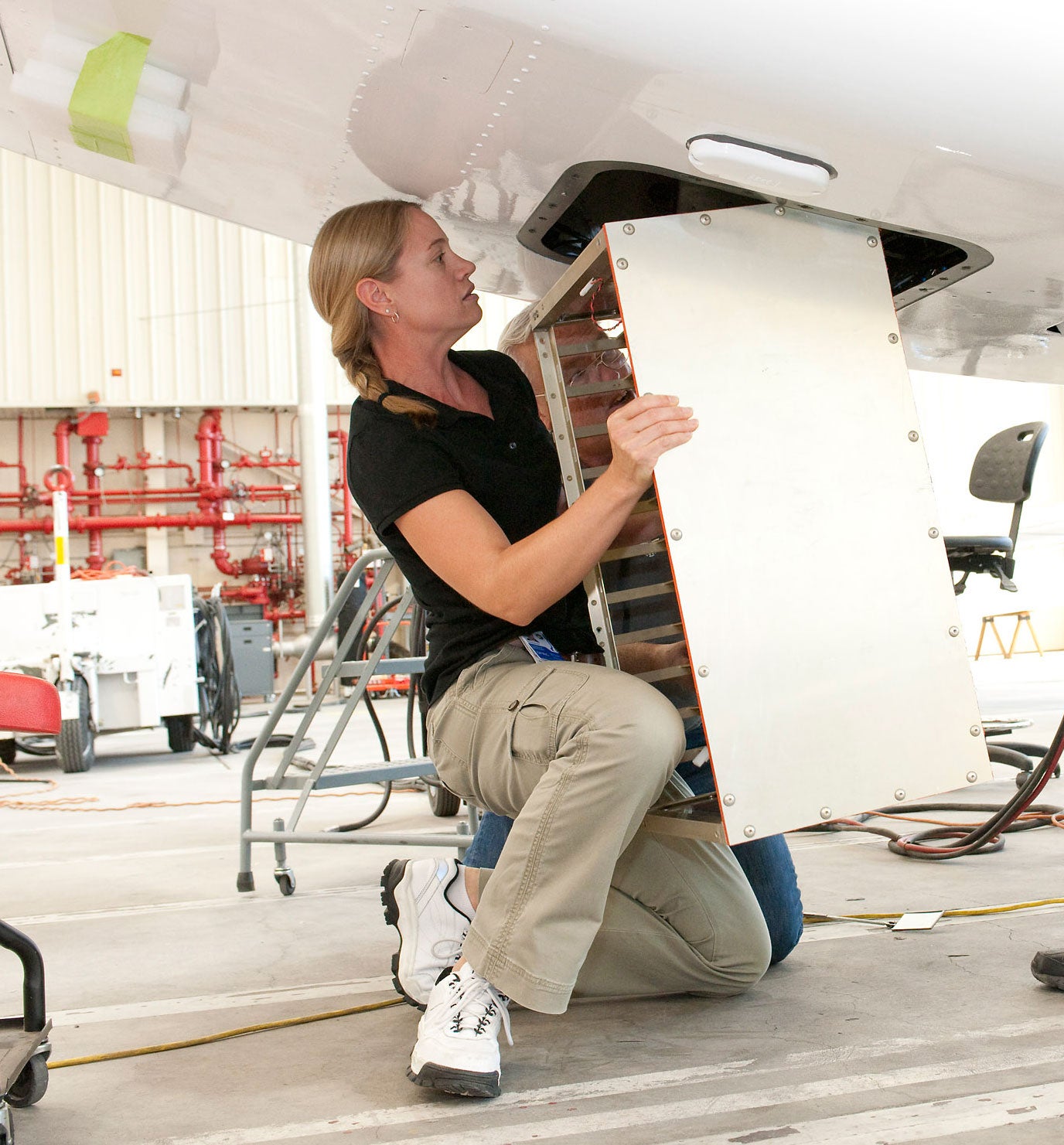 |
| Figure 1. The NCAR/EOL AVAPS system aboard the AV-6 for HS3. Click image to enlarge. |
The potential for scientific advances made possible by data collected during the HS3 campaign cannot be overstated. This is primarily because the NASA Global Hawk aircraft offered unique capabilities unavailable during previous aircraft field campaigns that studied tropical cyclones. First, with a flight time of up to 28 hrs, the Global Hawk is able to provide an unprecedented amount of time over a hurricane to collect observations. This improved temporal coverage has the potential to eliminate the sampling gap issues noted in previous campaigns, and is necessary to observe processes such as rapid intensification that occur on a timescale of a few hours. Second, the extended range of the Global Hawk (20,278 km) allowed sampling of the entire Atlantic basin from the western Caribbean to the northeastern Atlantic Ocean. Finally, with flight levels as high as 19.8 km, the Global Hawk is able to provide profiles of atmospheric constituents from altitudes never reached before by a research aircraft over a hurricane. These high altitude vertical profiles are critical to understanding storm and convective-scale processes. A specific example is the ability to accurately calculate observed vertically integrated quantities such as Convective Available Potential Energy (CAPE) and Convective INhibition (CIN) within a disturbance. Calculation of these observed quantities will allow hurricane researchers to understand the strength and role that parcel buoyancy and convective-scale updraft potential have in spinning up disturbances in the lower levels of the troposphere.
One of the best demonstrations of the NASA Global Hawk capabilities occurred during observations of Hurricane Nadine in the 2012 portion of the campaign. Five Global Hawk flights were conducted for Nadine (Fig. 2). The storm was interesting in that it was one on the longest-lived tropical storms on record. While Hurricane Nadine originated as a wave along the African Easterly Jet and began tracking initially westward, it eventually recurved to the northeast and threatened the Azores for a short period of time. While in the northeastern Atlantic basin, the storm underwent a series of intensifications and decays. Data collected during HS3 helped scientists understand the storm evolution and how a protective wave pouch (Dunkerton et al. 2009) is able to provide a favorable environment for a disturbance to intensify, despite its location adjacent to a hostile environment characterized by low sea surface temperatures and strong vertical wind shear (Blake Rutherford, personnel communication).
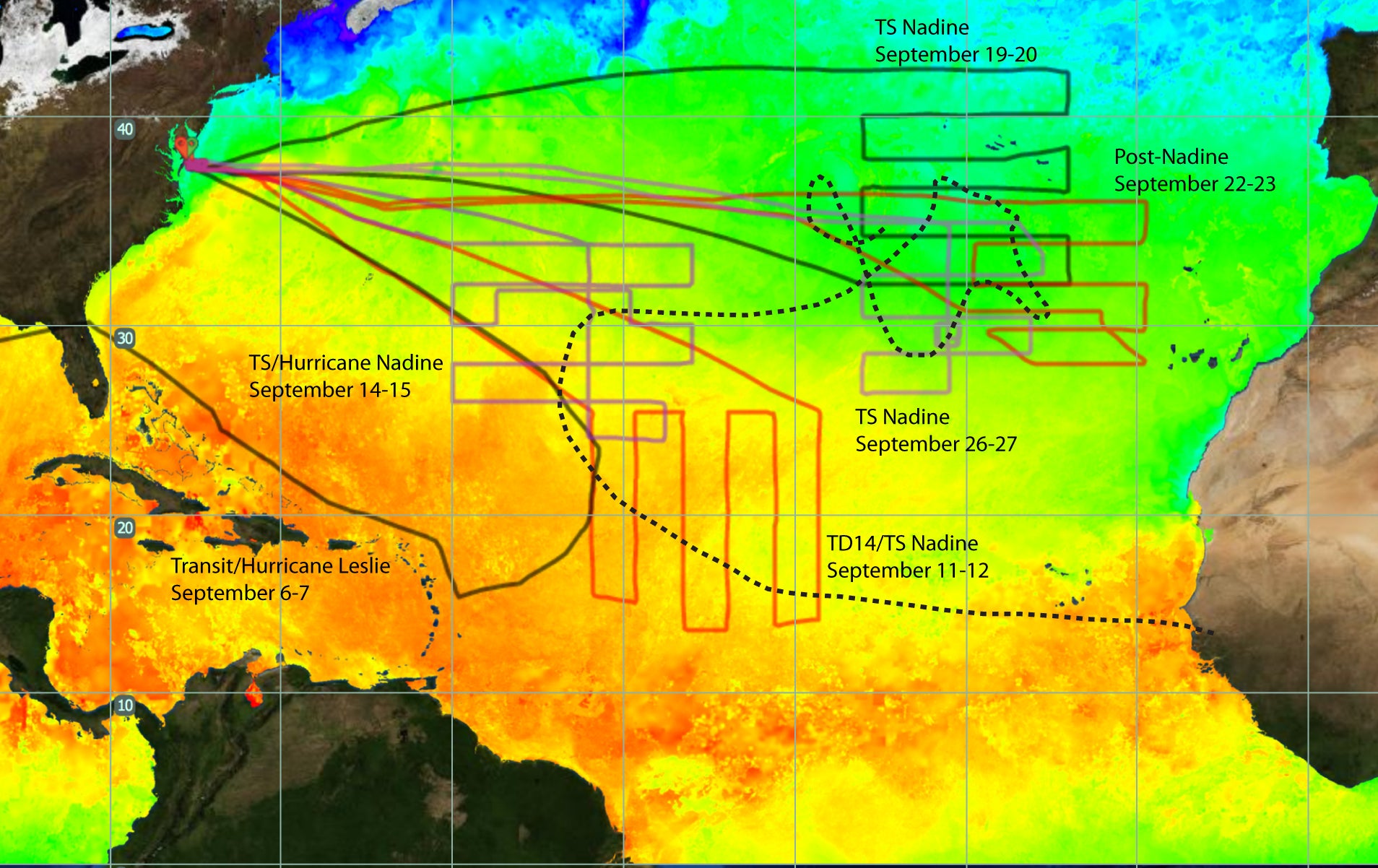 |
| Figure 2. NASA Global Hawk flights into Hurricane Nadine (solid lines) and track of Hurricane Nadine (dotted line). Picture reproduced from NASA. Click image to enlarge. |
The 2014 campaign that lasted from mid-August to late September offered another set of interesting storms to study. AV-6 flew a total of 236 hour targeting three named storms, the Saharan Air Layer, and a tricky intercomparison with dropwindsondes dropped from NOAA's GIV. Of particular scientific interest, 282 dropwindsondes were dropped into the initial disturbance, rapid intensification to a Category 3, and subsequent final decay of Edouard during research flights 5 to 8. Paul Newman, one of the two chief PIs, elatedly described Edouard as the type of system that HS3 had envisioned to sample when the original proposal was formulated. Furthermore, research flights 9 and 10 flight heavily sampled the equatorial Atlantic and were described as historic because this was the first time that a major part of the Main Development Region (MDR) was systematically sampled since the GATE experiment in 1974. In response to the success of HS3, ISF was recently informed by NOAA that they will receive funding to support the next Global Hawk program called Sensing Hazards with Operational Unmanned Technology (SHOUT), NOAA's multi-year plan to deploy the aircraft for high impact weather.
References:
Braun, S. A., 2010: Reevaluating the Role of the Saharan Air Layer in Atlantic Tropical Cyclogenesis and Evolution. Mon. Wea. Rev., 138, 2007–2037.
Dunion, J. P., and C. S. Velden, 2004: The impact of the Saharan air layer on Atlantic tropical cyclone activity. Bull. Amer. Meteor. Soc., 84, 353–365.
Dunkerton, T. D., M. T. Montgomery, and Z. Wang, 2009: Tropical cyclogenesis in a tropical wave critical layer: easterly waves. Atmos. Chem. Phys., 9, 5587-5646.
http://www.nasa.gov/mission_pages/hurricanes/missions/hs3/

.jpg")
.jpg")