SWEX
Sundowner Winds Experiment
Downslope windstorms at the lee of the Santa Ynez Mountains (SYM) in Santa Barbara County are one of the most significant fire weather hazards affecting populated areas. These gusty "Sundowner" winds peak from early evening to mid-morning. Modeling results show that the intensity and spatial variation of Sundowners are driven by a combination of dynamic and thermodynamic mechanisms that depend on the complex-terrain boundary layer dynamics, profiles of winds and stability. The main goal of this proposal was to improve the current understanding of the dynamics and predictability of downslope windstorms in coastal Santa Barbara County. This science proposal was in support of the proposal “Sundowner Winds Experiment” (SWEX) submitted to NCAR/LAOF. The three main scientific objectives are:
- Investigate how boundary layer structure and dynamics spanning the SYM and Santa Ynez Valley influence Sundowner winds intensity, timing and geographic characteristics,
- Examine mechanisms relating high amplitude mountain waves, critical layers, and surface wind intensity, and
- Investigate how variations in boundary layer structure and tropospheric stability impact the predictability of Sundowner winds.
Intellectual Merit
The proposal brought together a research team with vast and diverse experiences in atmospheric sciences, regional modeling, and extensive experience in field campaigns. SWEX was the first campaign in Southern California to investigate mechanisms driving downslope windstorms in the lee of a narrow mountain range in the subtropics, influenced by complex interactions with a cool, stable and shallow marine boundary layer with distinct spatial characteristics and dynamics.
Additionally, the SWEX campaign investigated how mountain-wave theory can be applied in this environment, providing a rich data set for predictability studies of downslope windstorms in coastal areas in the subtropics with a Mediterranean climate. The proposal enhanced ground observations with an adequate network of surface flux towers, integrated sounding systems, wind profilers, and mobile measurement to test specific hypotheses about boundary layer structure, mountain wave activity and Sundowners. These studies will contribute to improving the lead-time forecast of Sundowners.
Results obtained during SWEX will significantly advance understanding of downslope flows and windstorms affecting mountains in coastal areas, where the erosion and displacement of the shallow marine boundary layer can contribute to the characteristics of winds, wind gusts, temperature and humidity in the lee of the mountains and near ground level.
Broader Impacts
This proposal dynamically and creatively integrated scientists and operational forecasters to increase understanding and improve the predictability of Sundowner winds. The project will efficiently transfer research findings to National Weather Service Los Angeles/Oxnard Office (NWS/LOX), Santa Barbara County Fire Department.
The project had strong educational and mentoring components and directly supported the research of Postdoctoral researchers and thesis research of five graduate students among participating universities.
Results from this project will be incorporated into graduate and undergraduate curriculum. This project will inform the public about mountain and coastal weather, fire weather, and natural disasters. A website will be created to disseminate these ideas in non-technical communication. Moreover, PIs, Postdoctoral researchers and graduate students will be encouraged to educate the general population and young generation (K-12) during the annual outreach event ‘Geography Awareness Week” organized by students, staff and faculty in the Department of Geography (UCSB). This yearly event is aimed at global citizens of all ages and increases awareness about the relationships between people and the environment.
Study Area
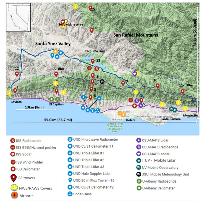
Figure 1. Topography and proposed spatial distribution of instruments. Red pin symbols indicate ISFS [tower] stations. ISFS stations 1-4 are located in the foothills of the SYM; ISFS stations 7-11 are located at the crest of the SYM; ISFS stations 5-6 are at intermediate elevations in the same transect. ISFS stations 12-13 are in the SYV, and 14-15 are in the San Rafael Range. Yellow circles indicate all NWS and RAWS stations presently in operation. All airports have weather stations, and the Santa Barbara airport has a 449MHz radar wind profiler (orange symbol). ISS radiosonde, wind profiler, and SODAR are shown with red symbols (interpretation provided in the map). Additional instruments provided by PIs are indicated with different colors. Symbols are the same for a similar type of instrument.
Principal Investigators
Leila Carvalho, University of California, Santa Barbara
Charles Jones, University of California, Santa Barbara
Gert-Jan Duine, University of California, Santa Barbara
Joe Fernando, University of Notre Dame
Craig Clements, San Jose State University
Stephan De Wekker, University of Virginia
David Fitzjarrald, University of Albany
Robert Fovell, University of Albany
Zhien Wang, CU Boulder
Loren White, Jackson State University
EOL PMO Project Manager
Alison Rockwell
EOL Facility Project Managers
Steve Oncley, ISFS
Bill Brown, ISS
Data Manager
EOL Archive NCAR/EOL/DMS