PRECIP-98
Precipitation Project 1998
During the summer of 1998 the National Center for Atmospheric Research (NCAR)’s S-band, dual-polarization radar (S-Pol) was deployed in east-central Florida during a special field experiment (PRECIP-98) to evaluate the potential of polarimetric radar to estimate rainfall in a subtropical environment. The experiment coincided with field components of the National Aeronautics and Space Administration (NASA)’s third Convection and Moisture Experiment (CAMEX-3) and NASA’s Tropical Rainfall Measuring Mission (TRMM) ground evaluation study, named the Texas and Florida Underflights Experiment (TEFLUN-B). The S-Pol component of PRECIP98/CAMEX-3/TEFLUN-B was sponsored by the U.S. National Science Foundation (NSF).
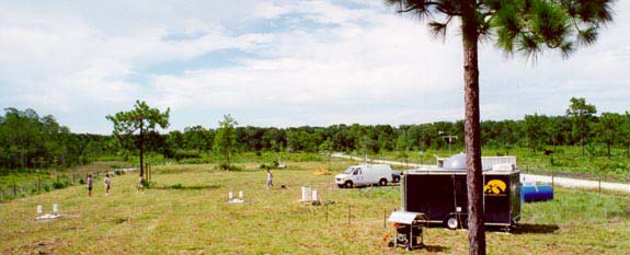
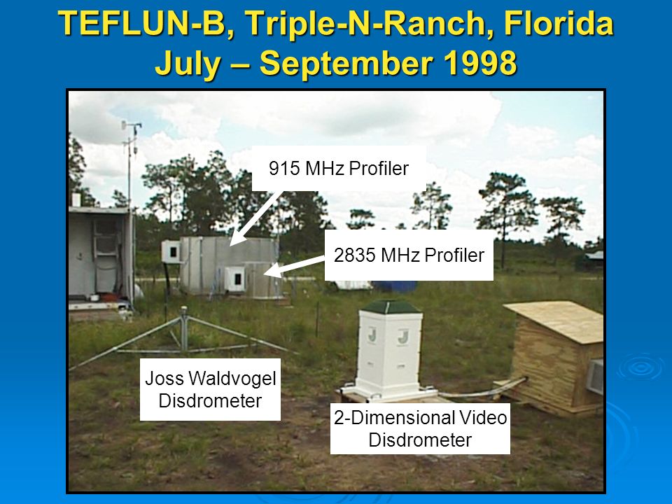
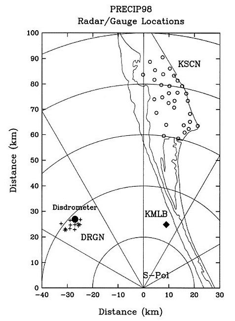
S-Pol was located 26 km south-southwest of the operational National Weather Service (NWS) Weather Surveillance Radar-1988 Doppler (WSR-88D) at Melbourne, Florida, (KMLB). The radar operated daily from 21 July until 28 September 1998. Emphasis was on rainfall estimation, comparing estimates derived from polarimetric variables with rainfall observations obtained from a dense rain gauge network at the Kennedy Space Center (KSCN) and from a special NASA Dense Rain Gauge Network (DRGN) with gauges installed singly and in small clusters at the Triple-N Ranch near Hollopaw, FL. The KSCN was located about 40-km west of Melbourne and 60–90 km, and the DRGN was 35–41 km from the S-Pol radar (see Network Maps). Both networks consisted of tipping-bucket gauges that recorded either the clock time of each tip (0.01 in. or 0.254 mm) or the number of tips in 10-s intervals. Fourteen gauges were arranged with separation distances ranging from a few meters to about 8 km. Within the network, three dual-gauge platforms provided rainfall observations separated by distances as small as 1-m. The Iowa Institute of Hydraulic Research (IIHR) of the University of Iowa, operated their Mobile Rainfall Observatory, which included a trailer-based vertically pointing X-band radar (owned jointly with the Hydrologic Research Center of San Diego, California), a 2-D video distrometer, dual-design tipping-bucket raingauges, and other surface meteorological instruments. The National Oceanographic and Atmospheric Administration (NOAA)’s Aeronomy Laboratory (AL) 915-MHz Doppler Profiler was co-located at the IIHR site.
 |
SCIENTIFIC OBJECTIVES
PRECIP-98
The main goal of PRECIP-98 was to evaluate the potential of polarimetric radar to estimate rainfall in a subtropical environment with emphasis was on comparing estimates derived from polarimetric variables with rainfall observations obtained from dense rain gauge networks. PRECIP-98 coordinated measurements and observations with the coincident NASA CAMEX-3 and TEFLUN-B projects conducted in Central Florida.
CAMEX-3
The CAMEX-3 coordinated with the National Oceanographic and Atmospheric Administration (NOAA)’s Hurricane Research Division (HRD) to develop joint research strategies to (1) investigate the interplay of hurricane inner core dynamics with the upper tropospheric environment; (2) study the relationship of the synoptic flow environment to hurricane tracking and intensity change; (3) explore parameters pertinent to improving quantitative precipitation forecasting of landfalling hurricanes; and (4) sample the environment of potential hurricane genesis conditions. The CAMEX-3 field phase was based in central Florida, with NASA aircraft (ER-2 and DC-8) and a cloud physics aircraft deployed at Patrick Air Force Base (AFB), and NOAA aircraft at MacDill AFB. In conjunction with the airborne observations, a ground-based validation site was established on Andros Island, Bahamas. Using rawinsondes, a lidar, and a radiance interferometer, the ground validation team made regular observations providing vertical retrievals of temperature, humidity, winds, and water vapor profiles. The CAMEX-3 field experiment was conducted from 8 August to 27 September 1998 and included operations in hurricanes Bonnie, Danielle, Earl, and Georges.
TEFLUN-B
In addition to the CAMEX-3 airborne and surface field operations, the TEFLUN-B experiment (located in central Florida during August and September 1998) provided additional ground validation observations. TEFLUN-B, the second of its kind, was a TRMM precipitation experiment designed to obtain airborne and surface measurements needed to validate the TRMM rainfall algorithms. The main goal of the TRMM satellite (launched in 1997) was to provide accurate estimates of global tropical rainfall through two sensors, including a Precipitation Radar and Microwave Imager. The main foci of the TEFLUN-B project was on (1) quantification of radar-rainfall uncertainty; (2) exploratory analysis of the observations to shed light on the observed rainfall variability; and (3) application of the Error Variance Separation Method (EVSM) to the TRMM radar maps using independent gauge observations from dense raingauge networks. The EVSM is a statistical procedure that allows practical assessment of the radar-rainfall error characteristics. In addition, upper-air soundings were obtained from two mobile systems to provide initialization and validation data for models at strategic times and locations.
OBSERVATIONS/DATA (from all three coincident projects)
Instruments flown on the NASA ER-2 aircraft included: (1) ER-2 Doppler Radar (EDOP); (2) Advanced Microwave Precipitation Radiometer (AMPR); (3) Lightning Instrument Package (LIP); (4) Multispectral Atmospheric Mapping Sounder (MAMS); (5) MODIS Airborne Simulator (MAS); (6) ER-2 High-Altitude Dropsonde (EHAD); and the (7) Millimeter Imaging Radiometer (MIR). There were several other important ER-2 instruments that flew including the Sub-millimeter Limb Sounder (SLS), (NAST-I) and (NAST-M), and telemetry using STARLINK.
Primary Instruments flown on the NASA DC-8 aircraft included: (1) Airborne Rain Mapping Radar (ARMAR); (2) Polarimetric Scanning Radiometer (PSR); (3) Airborne Multichannel Microwave Radiometer (AMMR); (4) Lightning Instrument Package (LIP); and (5) Cloud/Aerosol Particle Characterization (CAPAC) package. Dropsondes were released using the GPS system developed by NCAR.
The basic instrumentation package aboard the University of North Dakota (UND) Citation II aircraft measured temperature, dew point temperature, pressure, wind and cloud microphysical characteristics along with aircraft position, attitude and performance parameters. Cloud microphysical measurements were made with an array of Particle Measuring Systems probes (FSSP, 1D-C, 2D-C, 1D-P) mounted on the wing tip pylons. In addition, there were probes to measure both liquid water content (CSIRO) and icing rate (Rosemount icing meter).
 |
| Aircraft | NASA ER-2; NASA DC-8; NOAA P-3; UND Citation |
|---|---|
| Profiler | NOAA AL 915-MHz Doppler Profiler system |
| Radar | NCAR S-Pol S-band dual polarization radar; NWS Melbourne WSR-88D Doppler radar; IIHR X-band vertically pointing radar |
| Satellite | TRMM Data and derived products |
| Surface | NASA Raingauge Network (DRGN); NASA Kennedy Space Center Raingauge Network (KSCN) |
| Surface | IIHR Video 2-D Distrometer; JOSS Distrometer; and APL Distrometer |
| Upper Air | NASA Mobile Sounding systems (2) |
NETWORK MAPS
 |
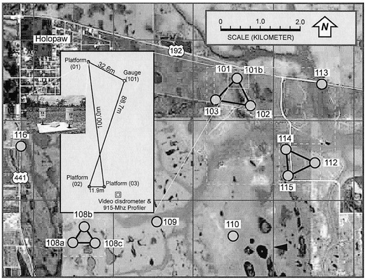 |
Layout of NASA’s DRGN cluster. The inset in the figure shows the University of Iowa’s three dual-gauge platforms, the 2D video disdrometer, and the 915-MHz Doppler profiler, as set up at the Triple Ranch site in Melbourne, FL. The 2 x 2 km2 grid (solid lines) shows the Cartesian pixels of the 2A-53 radar rain maps. The dashed boxes show areas used for intermittence analysis.
Further information on PRECIP-98 can be found: Precip98_Overview.pdf
Further information on TEFLUN-B can be found: TEFLUN-B_Overview.pdf
Further information on CAMEX-3 can be found: CAMEX-3_Overview.pdf
Principal Investigators:
- Edward Brandes NCAR/RAP
Data Manager:
- Bob Rilling NCAR/EOL
- EOL Archive, NCAR/EOL/DMS