KOFSE/KuDA
Kuwait Oil-Fire Smoke Experiment/Kuwait Data Archive
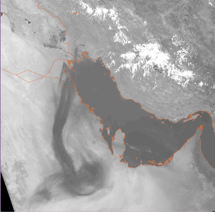
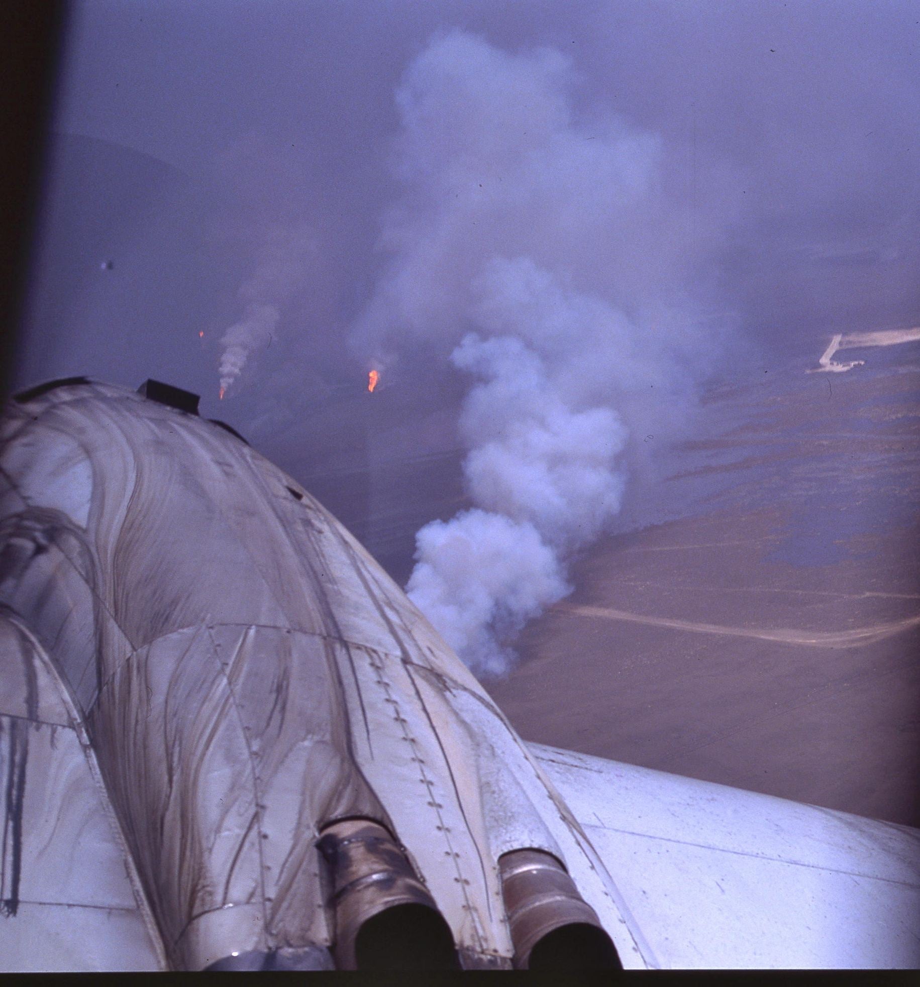
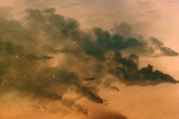
The burning of the Kuwait oil fields following the Gulf War in 1991 generated world-wide interest in the potential environmental impacts of this major anthropogenic episode. The magnitude of this event was unprecedented, and initial estimates were that it could take up to two years to extinguish all the fires. After the end of the war, surveys of the damage in the oil fields began. Over 600 wells in eight fields were actively burning, and over 150 wells were damaged. An estimated six million barrels of oil were burning per day, emitting more than 3000 metric tons of soot per day into the atmosphere. These fires burned for nearly 6 months and produced a large-scale plume visible from satellite photographs and easily tracked and measured by aircraft. Many of the damaged wells were spewing oil, forming large pools of oil on the desert surface. Additionally, between six and eight million barrels of oil were discharged into the Gulf. The alarm generated by the potential environmental devastation prompted numerous governments to offer assistance in assessing the environmental damage. Many of these efforts were coordinated by the World Meteorological Organization (WMO). Teams from Europe, North America, Japan, and the Gulf Region were sent to monitor various environmental effects. U.S. agency funding support were provided from the National Science Foundation (NSF), Defense Nuclear Agency (DNA), National Oceanographic and Atmospheric Administration (NOAA), Environmental Protection Agency (EPA), and Department of Energy (DOE).
 |
 |
EXPERIMENTAL GOALS
Concern from the scientific community over possible impacts on regional and global climate quickly arose from intense smoke and heat distributed over an area of only a few thousand square kilometers. As this smoke drifted away from the oil fields, the plumes were influenced by land-sea breeze circulations, lofting caused by solar heating, and spreading caused by the combined efforts of wind shear and turbulent diffusion. The smoke plumes provided opportunities to study the transport and diffusion of pollutants at large scales in a complex setting. Experiments were conducted in Kuwait and downwind. Studies included such topics as health effects, plume dispersion modeling, obscuration caused by smoke, turbulence induced by the plume, and detection of smoke from satellite sensors.
 Photos Courtesy of Robert Bumpas_1.png) |
 |
OBSERVATIONS/DATA
The various types of measurements collected demonstrated the interdisciplinary interest in the event. Air chemistry, smoke optical properties, particulate concentrations, and meteorological state parameters were monitored from surface-based and airborne platforms. Given the diversity of data sources and broad interest in this dataset, the need for a central archive which would provide convenient access to all measurements was quickly recognized and led to the establishment of the Kuwait Data Archive (KuDA) hosted at NCAR following a sponsored WMO Workshop at NCAR in July 1991.
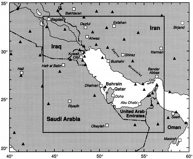
Aircraft operations were conducted by the NCAR, University of Washington (UW), British Meteorological Service, U.S. Department of Energy (DOE) Battelle Pacific Northwest Laboratory, and the German Ministry of Environmental Protection (MEP). These measurements included atmospheric state parameters, air chemistry, radiation (terrestrial and solar), particle concentrations, laser spectrometers, lidars, aerosols/cloud physics and dropsondes. There were approximately 60 flights into the Persian Gulf region during the March-August 1991 period from the base of aircraft operations in Bahrain.
Special air quality monitoring sites were established at various sites in Saudi Arabia and Kuwait after the fires began, including measurements taken by the Saudi Arabian Meteorological and Environmental Protection Agency (MEPA) and the U.S. Defense Nuclear Agency. NOAA also established a network of Meteorological Towers. Other surface and upper air measurements included routine synoptic observations in the Gulf Region.
Gridded fields from the U.S. National Meteorological Center (NMC) global forecasting models were archived for subsets of the period January-December 1991 over a variably sized region centered on the gulf. Each set of model output includes fields of temperature, humidity, pressure/height, and wind velocity components. In general, only analysis fields were archived; the exception is the special Medium Range Forecast dataset, which also contains 6-h forecast fields.
High-resolution digital satellite images from all from polar-orbiting meteorological satellites were collected by a ground station operated by the U.S. Air Force in Saudi Arabia. This station collected an extensive digital archive of High Resolution Picture Transmission (HRPT) imagery from four NOAA polar-orbiting satellites (NOAA-9, NOAA-W, NOAA-11, and NOAA-12), as well as Operational Linescan System (OLS) imagery from three satellites in the Defense Meteorological Satellite Program (DMSP). These datasets were augmented with local area coverage (LAC) digital imagery acquired from NOAA archives. LAC and HRPT datasets are both made up of high resolution (1.1 km at nadir) multispectral (five channel) imagery obtained by the Advanced Very High Resolution Radiometer (AVHRR) flown on the NOAA polar-orbiting satellites. All five AVHRR channels were archived. OLS data from the DMSP satellites were archived from two channels (visible and thermal IR). The OLS visible data have a resolution of 550 m (at nadir), while the corresponding IR data have a resolution of only 2.7 km.
| Aircraft | NCAR Electra, UW Convair C-131A, German MEP Piper Navajo Chieftian, Battelle (US DOE) Gulfstream-I, British Meteorological Service C-130 |
|---|---|
| Model | NMC MRF analysis and special runs |
| Model | NMC spectral |
| Model | NMC flux fields |
| Satellite | NOAA AVHRR GAC Imagery |
| Satellite | NOAA AVHRR LAC/HRPT Imagery |
| Satellite | DOD DMSP Imagery |
| Surface | Saudi Arabian MEPA Air Quality measurements |
| Surface | DNA/SAIC Radiometric Measurements |
| Surface | NOAA Meteorological Towers |
| Surface | Routine synoptic observations |
| Upper Air | Routine synoptic observations |
NETWORK MAP
 |
Principal Investigators:
- Battelle
- British Meteorological Service
- Obirin University
- Saudi Meteorological and Environmental Protection Administration (MEPA)
- University of Washington
Data Manager:
- EOL Archive NCAR/EOL/DMS