SHEBA
Surface Heat Budget of the Arctic Ocean Project
Project Description:
The Surface Heat Budget of the Arctic Ocean (SHEBA) was a research program designed to document, understand, and predict the physical processes that determine the surface energy budget and the sea-ice mass balance in the Arctic. The central motivation behind SHEBA lied in the fact that the Arctic had recently undergone significant changes that are were hypothesized to be a combination of poorly understood natural modes of variability and anthropogenic greenhouse warming. In addition, general circulation models (GCMs) have had large discrepancies in predictions of present and future climate in the Arctic, and consequently, large uncertainties about the how the Arctic influenced global climate change. These difficulties were due, in large part, to an incomplete understanding of the physics of the vertical and horizontal energy exchanges within the ocean-ice-atmosphere system. The SHEBA program was based on the premise that improved understanding of physical processes was needed, and that such understanding must be based on detailed empirical observations. Further, the SHEBA project was focused on enhancing understanding of the key processes that determine ice albedo feedback in the arctic pack ice and on applying this knowledge to improve climate modeling.
Phase I of SHEBA (1995-96) involved analysis of historical Arctic datasets, preliminary modeling studies, and development of instrumentation that would be suitable for providing critical measurements in the demanding arctic environment. Phase II of SHEBA (1997-99) was a year-long field experiment (2 October 1997-12 October 1998), on a drifting station in the pack ice of the Arctic Ocean. The observational program emphasized a coordinated, interdisciplinary measurement effort that provided the necessary information needed to examine the physical processes associated with interactions among the radiation balance, mass changes of the sea ice, storage and retrieval of heat in the mixed layer of the ocean, and the influence of clouds on the surface energy balance. Phase III of the SHEBA program (2000-2002) included analyses of the comprehensive observational dataset and incorporation into a hierarchy of models.
SHEBA was a partner in a multi-agency arctic research effort. The research goals overlapped with the National Aeronautics and Space Administration (NASA) First International Satellite Cloud Climatology Project (ISCCP) Regional Experiment (FIRE)-Arctic Clouds Experiment (ACE), which conducted an extensive aircraft campaign over the SHEBA ice camp from April to July 1998. The goals of the FIRE-ACE program focused on the interactions between arctic clouds and the surface and radiative properties of spring and summer clouds. Similar to SHEBA, one of the end goals of FIRE-ACE was to improve climate model parameterizations of cloud and radiation processes, with additional emphasis on evaluating satellite retrievals of cloud and surface properties in the Arctic. The Department of Energy's Atmospheric Radiation Measurement (ARM) program collected information on atmospheric cloudiness and radiation from a site situated in Barrow, Alaska. The ARM program also contributed a significant suite of surface radiometers that were operated at the SHEBA ice camp. The three programs in combination were jointly dubbed SHEBA-ARMFIRE (SAFIRE). Other collaborating programs included the Japanese Marine and Science (JAMSTEC) buoy program, the RADARSAT Geophysical Processor System (RGPS), the Alaska SAR Facility (ASF), the Department of Fisheries Canada, the United States Coast Guard, and the Scientific Ice Expeditions (SCICEX) submarine program of the US Navy and NSF. SHEBA was primarily sponsored by the National Science Foundation (NSF) and the Office of Naval Research (ONR).
Scientific Objectives:
The primary goals of SHEBA were to: (1) Determine the ocean-ice-atmosphere processes that control the surface albedo and cloud-radiation feedback mechanisms over arctic pack ice, and to use this information to improve models of arctic ocean-atmosphere-ice interactive processes; and (2) Develop and implement models that improve the simulation of the present-day arctic climate, including its variability, utilizing coupled global climate models.
Specific objectives included: (1) Develop accurate physical and mathematical relationships between the state of the ice cover and albedo, for any given incident short-wave radiation; (2) Determine how the state of the ice cover changes in response to forcing from the atmosphere and the ocean; (3) Relate the surface forcing to conditions within the atmospheric and oceanic boundary layers; (4) Extend the relationships determined in Objectives 1-3 from local scales to the aggregate scales suitable for climate models; and (5) Establish a basic data set suitable for developing and testing climate models that incorporate the processes SHEBA is proposing to study.
Project Operations:
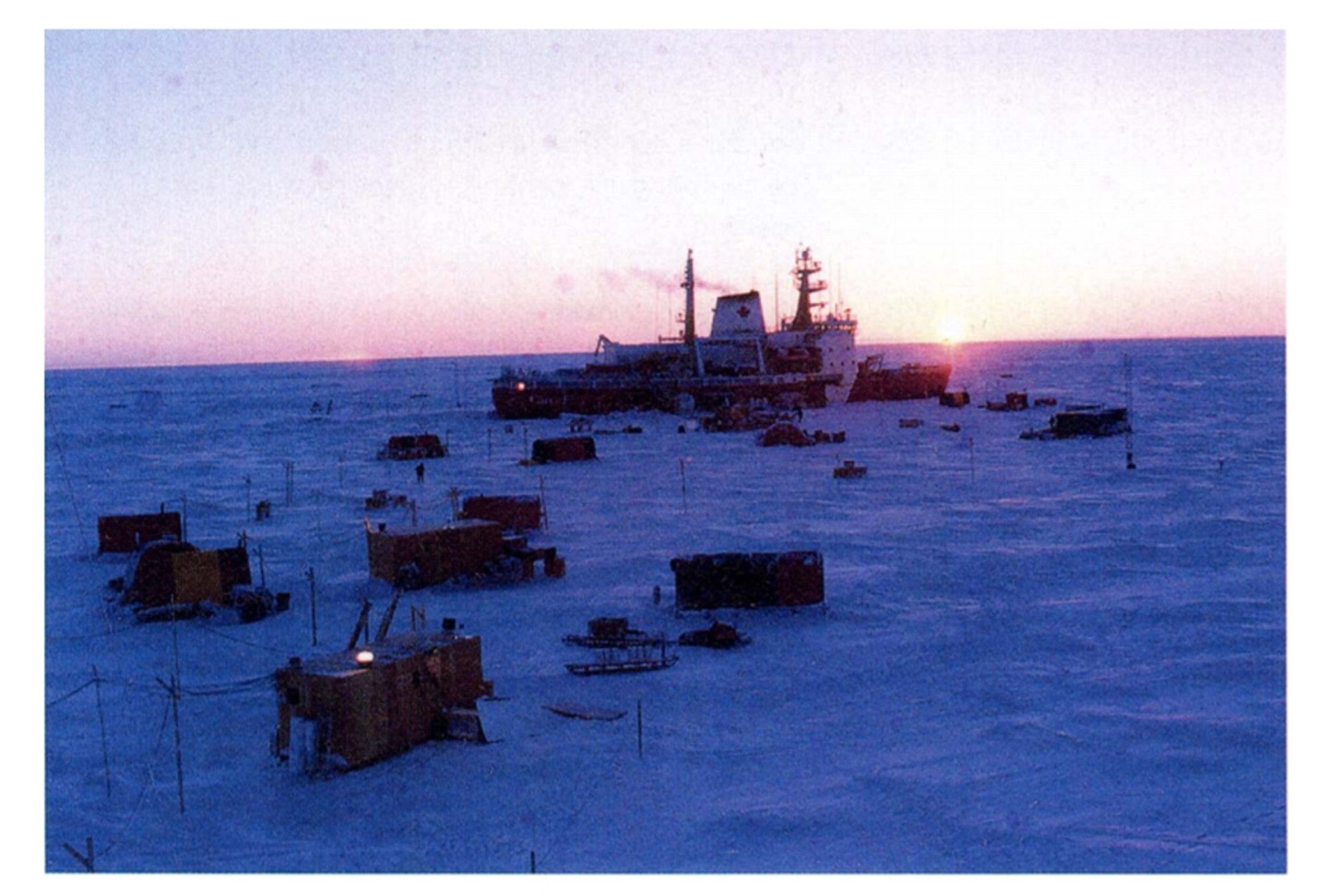
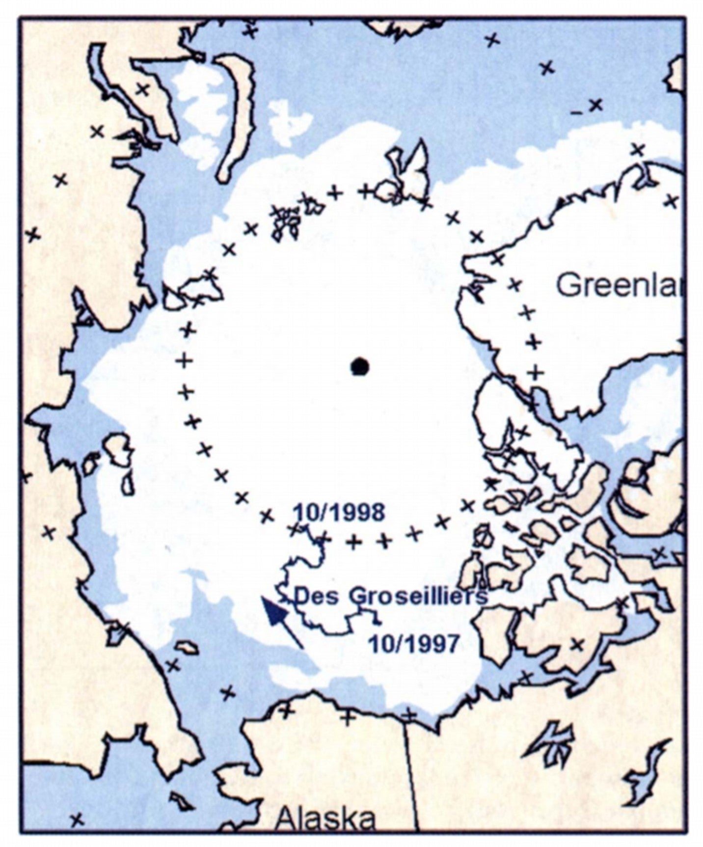
During SHEBA, the Canadian Coast Guard Ship Des Groseilliers was frozen into the ice at 75°N, 142°W about 570 km north and east of Prudhoe Bay, Alaska. The choice of a ship-based experiment was mandated not only by the number of people and experiments that were projected for SHEBA but the power requirements that otherwise would have had to be provided by diesel generators on the ice. The ship served as command center, power station, hotel, laboratory, staging area, and machine shop for the various SHEBA projects both on the ship's decks and on the ice surrounding the ship. The ship option was also determined to be the safest considering the number of personnel that would be rotating in and out of the ice camp.
The ice camp was installed in the fall of 1997 with the aid of a second Canadian icebreaker, the Louis St. Laurent, as the amount of equipment, supplies, and fuel greatly exceeded the cargo capacity of the Des Grosseilliers alone. The Des Groseilliers was packed with enough dry and frozen food to survive 16 months; the only provisions to be airlifted to the ship were fresh fruit and vegetables and other nonessential perishables. Transportation to and from the ship was accomplished through the use of Twin Otter aircraft that had the ability to take off and land on wheels, skids, or floats with extremely short runways. During the first 9 months of the drift, when aircraft support was used, seven runways of about 1000 ft x 60 ft were built or rebuilt supporting 57 landings and takeoffs. Most crew changes occurred after 6 weeks, with occasional 3-week rotations during special periods of setup and intensive observations. After the ice station drifted too far north, and the ice conditions became too treacherous for aircraft landings, the United States Coast Guard sister ships Polar Star and Polar Sea were utilized to complete personnel transfers. Radio communications with the land became unreliable as the ship drifted far to the west and north, but communications were maintained throughout the project utilizing INMARSAT-B satellite links.
The ice camp around the ship was comprised of numerous tents, seatainers, plywood structures, and towers that housed the bulk of the oceanographic, meteorological, and logistics operations. In addition, there were 960 50-gallon drums of various fuels for the ship, helicopters, and snow machines. This situation was of course vulnerable to lead activity and the unpredictable pattern of summertime melting. Significant resources were continually being applied to the problem of constant relocation of equipment and buildings as they came in danger of sinking or falling through the ice. It was fortunate that the 20-m meteorological tower, which was the only installation that could not have been relocated, was the only one that managed to stay in its original location for the entire drift. Throughout the year, the ship drifted over 1200 n mi through the Arctic Ocean. Two hundred scientists, a handful of media personnel, and 70 members of the Canadian Coast Guard lived at the station, with tours of duty ranging from two days to one individual who was on site for the entire experiment. Thirty-thousand meals were prepared, 3000 tons of freshwater were produced by desalinating ocean water, and the SHEBA experiment resulted in 374 scientifically productive days adrift in the Arctic Ocean without serious losses or damage to equipment or personnel.
Further information and details on SHEBA can be found at:
Uttal, T., and Coauthors, 2002: Surface Heat Budget of the Arctic Ocean. Bull. Amer. Meteor. Soc., 83, 255–276, https://doi.org/10.1175/1520-0477(2002)083<0255:SHBOTA>2.3.CO;2.