Sonic Anemometers
Orientation:
In order to report winds in geographic coordinates, the orientation of the instrument needs to be known. As part of their total survey of Perdigão instrumentation, DTU used their multistation to measure 4 points on each anemometer's mounting boom to determine azimuth, pitch, roll, and height of the instrument. These are documented in the Sensor Coordinates spreadsheet. Tilt-corrected data have been produced using these values, and all data in geographic coordinates have used these azimuth angles.
By agreement of the PIs, the masts were to be constructed with one face roughly parallel to the local height contour (which usually was preferred anyway for mast guying) and the anemometer boom to be mounted on this face, pointing up-valley (approximately SE). This was done to minimize distortion of the flow by the mast for winds perpendicular to the ridge lines (of most interest to the project) and also capture down-valley flow. Of course, the local slope direction varied over the domain, resulting in boom angles between 111 to 166 degrees. Also, local obstacles (trees and mast-mounted solar panels) sometimes interfered with this location for the anemometer. In these cases, the anemometer boom was set to point down-valley (180 degrees from the nominal orientation).
With the measured boom azimuth, the orientation of the CSAT3A anemometers is known since the anemometer head is rigidly attached to the boom. Also, the CSAT3 heads were attached in a captive manner, though the amount had +/-1 degree of "play". This effect was not measured and has been ignored in the definition of the boom angles. In one case, 10m.tse12, the anemometer head was found during tear-down to have been hit by a branch and was skewed by an estimated 20 degrees. This will take further examination to determine when this event (or events) occurred.
The other anemometer types -- Metek, Gill, and RMYoung -- were mounted either on vertical post or round plate that allowed the anemometer head to rotate with respect to the boom. Field staff attempted to align these sensors by eye in a consistent manner, but (unmeasured) errors of perhaps 2 degrees may be present. The Meteks were mounted so that the black arrows on the side of the head base were pointing towards the mast, with this side of the base parallel to the boom. The Gills were mounted so that the N indication on the head was aligned with the boom, pointing towards the mast. The RMYoungs mostly were mounted with the connector box at the base of the head mostly pointed towards the mast (and the face of the box's lid perpendicular to the boom). However, some RMYoungs mounted in the first set-up period may have had the connector box facing out (180 degrees from the others). Since not all of these cases were documented, we will determine them both from mast photos (most sites were documented during tear-down) and by noting which sites were set up early (e.g. rne02, rne01, rsw01, rsw02).
In post-processing, it was noticed that the tnw01 2m and 10m sonic cables appeared to have been swapped. This is now fixed.
Calibration:
[insert results of temperature chamber tests]
Operation:
Generally, these anemometers worked well throughout the project. Data have been removed when the sensors reported error flags, usually due to rain. The RMYoung anemometer at 10m.rne04 recorded two days of bad data until it was fixed on 20 May, that have been removed.
Water vapor/carbon dioxide sensors
A combination of Campbell Scientific EC-150 and LI-Cor Li7500 open-path infrared gas analyzers (IRGAs) were used for Perdigao. In general, these operated normally, with some bad data during rain events when the optical path was obscured.
Pre-calibrations were either done in the lab or by the manufacturer (for the EC-150s that were purchased new for this project), though calibrations could have shifted during shipping. Post calibrations were done on the EC-150s after they returned back to NCAR. Looking at field data, it is obvious that some sensors had significant biases and these biases changed with time. For most of the EC-150s, these biases did not appear to be consistent with the post-calibration results. Thus, biases have been removed based on a few periods between rain events in well-mixed conditions, using humidity from the closest TRH sensor for H2O and the median of all of the IRGAs for CO2. Offsets were from -4 to +2 g/m^3 in H2O and -40 to +25 mg/m^3 in C2O. This analysis emphasized the May/June data and may still contain offsets in earlier periods.
"Spikes" in the data occur frequently, that were likely due to rain. Using the sensors' internal diagnostic flag to filter the data does not remove all of these spikes. Thus, a simple threshold test (both minimum and maximum), manually adjusted for this dataset, has been used to remove the majority of the remaining spikes.
The sensor at v01 gave "source power" errors in its internal diagnostic for at least a few seconds in nearly every 5-minute period, but the data appear to be reasonable. We have allowed these data to remain in the archive.
ISFS usually produces fluxes corrected for spatial separation (between the anemometer and IRGA) and Webb, Pearman, Leuning for density. These corrections have not yet been applied.
TRHs
NCAR's standard Temperature/Relative Humidity sensors were deployed on all of the tall masts for the entire project. During the IOP, another 9 sensors were deployed on the shorter masts along the NW transect. Due to the clamping system that was used, it was possible for water to collect in the booms near the connector, that eventually caused failure of some of the sensors. We also found that some sensors just stopped for reasons that weren't clear. In these cases, the data are missing. Hopefully, most were serviced or replaced without too much data loss.
Fan Operation
In addition to total TRH failures, the fan controller electronics (and possibly also the fan itself) died, again presumably due to water infiltration. In most cases, the sensor was revived by changing the wiring to bypass the electronics board, allowing the sensor to operate but giving no feedback on fan operation. For the sensors that had working fan controllers, we have used this information to remove data when the fan was not operating properly. For the sensors with the controller bypassed, we have determined when the fan was not working properly by examining temperatures relative to nearby TRH sensors. [We should include Matt's sensor table.]
Calibration
Pre- and post-calibrations were done on every sensor in the EOL Calibration Laboratory. [These cals are available -- need to summarize or make a table to list any issues]
Barometers
PTB220
6 Vaisala PTB220s were deployed. They operated normally.
Nanobarometer
The 4 NCAR nanobarometers were deployed as microbarographs. They operated normally.
Setra
These were supplied by Cornell University and used at 4 locations as microbarographs. Data from the sensor at rsw03 were found to have picked up excessive noise due to the long analog cable that was used, which will limit the utility of its data. Unfortunately, this noise was not detected until after the field program. Otherwise, they operated normally.
Radiometers
NR01 integrated radiometers were used at 13 sites, mounted on booms extending from near the top of the masts. They were never cleaned, though rain during the first half of the IOP probably reduced dust/pollen build-up. For this reason, each sensor was tested upon return to Boulder after the experiment. [refer to Wiki? description of the results]
Data from the incoming sensors (Rsw.in, Rpile.in [used to compute Rlw.in]) have been removed when the wetness sensor indicated that moisture was present, that would affect radiation measurements.
Another issue with the tower-mounted NR01s was that many had solar panels (also mounted on the south sides of the towers) in the field of view. It is not clear how to quantify how these panels affected the measurements.
Another 3 sites each had a set of 4-component radiometers mounted on our "darkhorses". Again, these were not cleaned. The incoming pyrgeometer (Rlw.in) failed at this site, intermittently on 26 May and failing completely on 2 June. An extra NR01 was installed at this location on 10 June to provide the radiation meaasurement.
Rlw has been calculated from the pyrgeometer Rpile and Tcase measurements in the 5min statistics files. Rsum also has been calculated as Rsw.in - Rsw.out + Rlw.in - Rlw.out.
Soils
Soil sensors were deployed at 16 sites. Most behaved as expected.
Tsoils
ISFS deployed our custom probes, with thermistor probes at 4 levels, linearly spaced from 0--5cm depth.
Due to a software error, field data with temperatures above 32 degC were reported as negative. These values have been fixed in post-processing, with no loss of data. Lightning strikes near some of the stations caused some sensors to fail and these data have been removed in the QC process. Finally, 4 of the probes (tnw09, rne06, rne07, and rsw04) had post-calibrations (in the lab) that differed significantly from their pre-calibrations. The post calibrations have been applied to the QC data set.
Qsoils
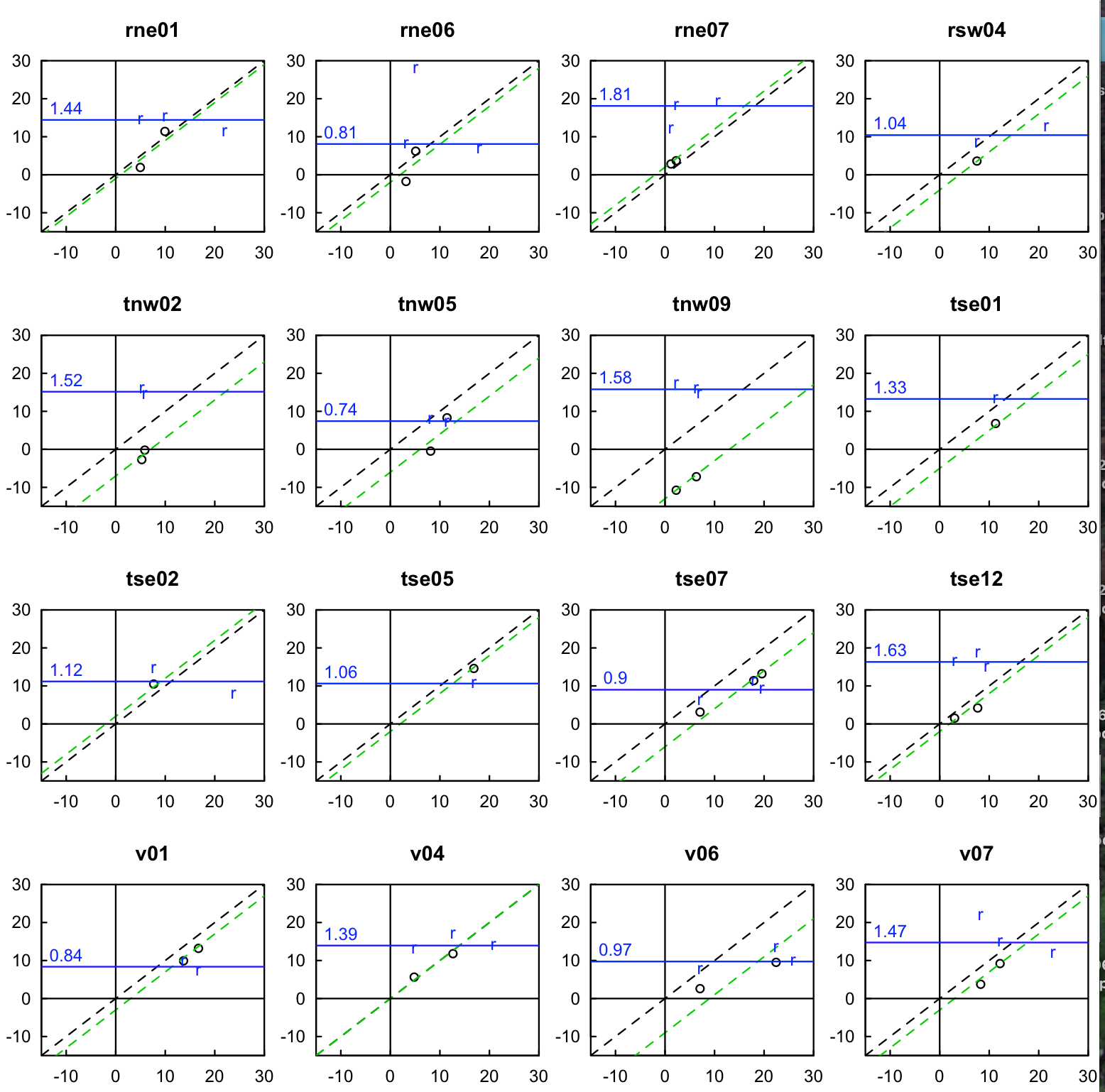
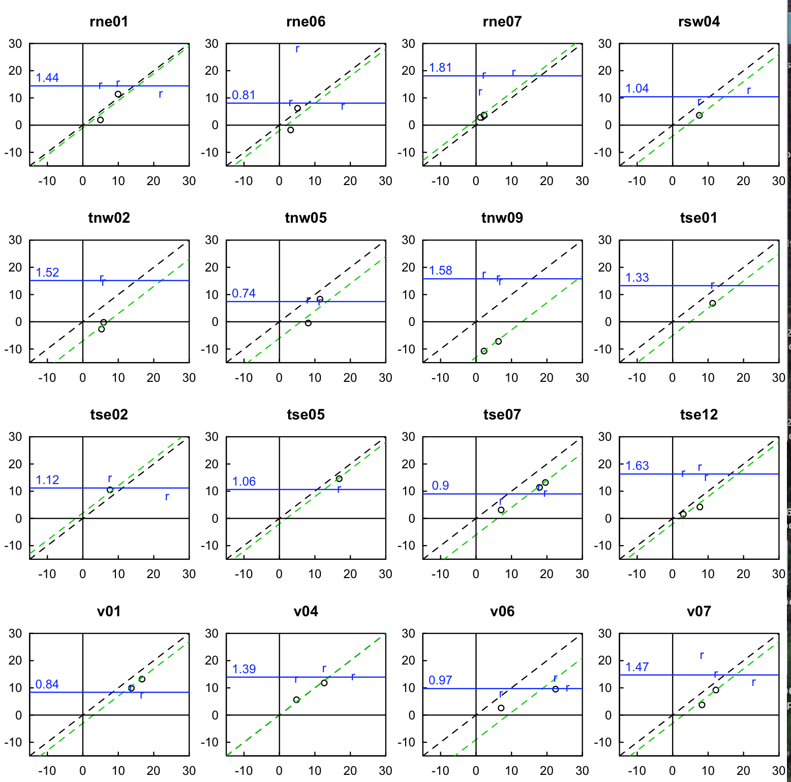
We deployed EcH2o EC-5 probes at 5cm depth. The output was checked by comparison with gravimetric samples taken manually 2 or 3 times during the project. Based on this analysis, biases of between -13 to +2% were found, and have been applied to the data. Below is a plot of these results, along with the mean soil bulk density found for each site. However, using gravimetric results to adjust the EC-5 readings still resulted in several sensors showing negative soil moisture readings during the final week of the project, when an extended drying period (associated with forest fires nearby) produced dry soils. Thus, we have arbitrarily further adjusted these readings according to the table below.
| Site | Gravimetric bias correction (%) | Final bias correction (%) |
|---|---|---|
| tnw02 | +7 | +9 |
| tnw05 | +6 | +6 |
| tnw09 | +13 | +14 |
| tse01 | +5 | +7 |
| tse02 | -2 | 0 |
| tse05 | +2 | +2 |
| tse07 | +6 | 0 |
| tse12 | +2 | +2 |
| rsw04 | +4 | +4 |
| rne01 | +1 | +1 |
| rne06 | +2 | +2 |
| rne07 | -2 | +3 |
| v01 | +3 | +3 |
| v04 | 0 | 0 |
| v06 | +9 | +5 |
| v07 | +3 | 0 |
Gsoils
REBS heat flux plates were installed at 5cm depth. These functioned normally. We will add derived values of the heat flux at the surface, Gsfc, corrected for heat storage in the 0--5cm layer.
Thermal properties
Hukseflux TP01 probes were installed at 2.5cm depth. These functioned normally. We will add derived values of soil heat capacity derived from this sensor.
Future work:
- Add H and LE calculations for the 16 energy balance sites to the statistics files
- Add 80m sonic orientation for the duplicated tower sensor from unpublished DTU scan [fixing]
- Determine if there are more socket data from DTU that haven't been processed or included
- Add in data from the quarentined files with wrong time tags/file names
- Pirga spikes
- w'h2o' noise (likely water)
- tnw01 2&10m sonics swapped [fixing]
- orientation of 10m.tse07 not included, will be picked up in future distributions
Perdigão Planning Meeting (May 2016)

