TOGA COARE
Tropical Ocean – Global Atmosphere (TOGA) Coupled Ocean Atmosphere Response Experiment (COARE)
The Tropical Ocean-Global Atmosphere (TOGA) was a major component of the World Climate Research Programme (WCRP) aimed specifically at the prediction of climate phenomena on time scales of months to years. The philosophy upon which TOGA was based purposefully emphasized the tropical oceans and their relationship to the global atmosphere. Underlying TOGA was the premise that the dynamic adjustment of the ocean in the tropics is far more rapid than at higher latitudes and, therefore, more closely in tune with the atmosphere. To gain a clear understanding of global climate change, the El Niño–Southern Oscillation (ENSO) phenomenon, and the intra-seasonal variability of the coupled atmosphere-ocean system, it was clear that a better specification of the coupling of the ocean and the atmosphere was required. An observational and modeling program, the TOGA Coupled Ocean Atmosphere Response Experiment (TOGA COARE), was designed to designed to address the objectives of TOGA above, and develop basic observational and modeling strategies to be employed.
The TOGA-COARE Intensive Observing Period (IOP) occurred from 1 November through 28 February 1993. During these 4 months, nearly 1,200 people from more than 20 nations conducted more than 700 days of ship operations, released nearly 12,000 rawinsondes, completed 125 aircraft flights, and maintained continuous operation of 30 moored instrument systems. In the months prior to and following the IOP, a few key atmospheric sounding systems and a few special oceanographic moorings were operated as part of the TOGA-COARE enhanced monitoring.
SCIENTIFIC OBJECTIVES
TOGA-COARE had four main science goals, aimed to describe and understand:
- The principal processes responsible for coupling of the ocean and the atmosphere in the western Pacific warm pool system;
- The principal atmospheric processes that organize convection in the warm pool region;
- The oceanic response to combined buoyancy and wind stress forcing in the western Pacific warm pool system; and
- The multiple-scale interactions that extend the oceanic and atmospheric influence of the western Pacific warm pool system to other regions and vice versa.
Collectively, the goals of TOGA-COARE were designed to provide an understanding of the role of the warm-pool regions of the tropics in the mean and transient state of the tropical ocean-atmosphere system. To carry out the goals of TOGA-COARE, three components of a major field experiment were defined:
- An interface component, in which the major emphasis was on the measurement and modeling of the interfacial fluxes between the atmosphere and the ocean over a wide variety of atmospheric and oceanic conditions.
- An atmospheric component, where the emphasis was on the measurement and modeling of those processes that determine the state of the atmospheric boundary layer, and, thus, influence the interfacial fluxes of heat, water, and momentum. Observations were taken over a full extent of weather conditions, ranging from the undisturbed trade-wind boundary layer to the disturbed boundary layer within convective complexes.
- An oceanographic component, where the emphasis was on the measurement and modeling of the response of the upper ocean in order to assess the response to the varying fluxes at the interface that occur over the range of weather events and types encountered in the warm pools of the tropical oceans.
OBSERVATIONS
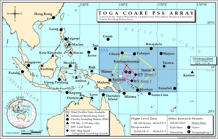
TOGA-COARE took place in the western Pacific warm-pool region between 20°N and 20°S, bounded by Indonesia on the west and the International Date Line on the east. Within this broad region were three principal COARE domains:
- The COARE Large-Scale Domain (LSD): The region 10°N to 10°S and 140°E to 180°. The region was chosen because it contains the warmest water, is the most convectively disturbed, and receives the greatest amount of precipitation in the tropical Pacific Ocean.
- The COARE Outer Sounding Array (OSA): The outer sounding array was defined within the large-scale domain by the meteorological sounding stations at: Truk, Ponape, Nauru, Honiara, Misima, and Kavieng.
- The Intensive Flux Array (IFA): The IFA was centered at 2°S, 156°E and bounded by the polygon defined by the meteorological stations of Kapingamarangi and Kavieng and ships located near 2°S, 158°E and 4°S, 155°E. A third ship was located near the center of the IFA (2°S, 156°E). The majority of the meteorological and oceanographic observations were conducted within the IFA.
 |
The experimental design called for a complex set of oceanographic and meteorological observations from a variety of platforms that carried out remote and in-situ measurements from these nested domains. The resulting high-quality dataset was required for the calculation of the interfacial fluxes of heat, momentum, and moisture, and providing ground truth for a wide range of remotely sensed variables for the calibration of satellite-derived algorithms. This satisfied the ultimate objective of the COARE dataset to improve air-sea interaction and boundary-layer parameterizations in models of the ocean and the atmosphere, and to validate coupled models.
DATA
The general observational strategy and data collection for TOGA-COARE varied by the 3 components of the Field Program:
- Interface Component - High-quality estimation of air-sea fluxes of sensible heat, latent heat, and momentum were critical element of TOGA COARE. The measurement and subsequent parameterizations of these fluxes provided, simultaneously, the surface forcing at the top of the ocean and at the bottom of the atmosphere. Besides the magnitude of the fluxes, their spatial and temporal variability needs were measured. On small scales, the fluxes were very intermittent, due to the fundamental nature of turbulence. On larger scales, features such as horizontal Sea Surface Temperature (SST) gradients caused large variations in the averaged fluxes due to the changes in stability of the air over different water temperatures. As the fluxes connected the upper ocean and the lower atmosphere, and were thus the local mode of communication between the two spheres, interface measurements had the highest priority in COARE.
- Atmospheric component - Developed an overlapping observational system. With this technique, similar to the type used in the GATE Program (1974) and more recently in AMEX (1987) and EMEX (1987), the consistency of in situ aircraft measurements were checked by the surrounding upper-air network, which provided estimates of gross budgets of moisture, heat, and momentum. Gross budget estimates were made using well-established budget techniques. Improved assimilation schemes and mesoscale models contributed significantly to the analysis of COARE observations.
- Oceanographic Component – A three-dimensional mixed-layer experiment integrated with atmospheric and interfacial components that provided air-sea fluxes of heat, moisture, and momentum. This mixed-layer experiment was designed to provide enough information to enable accurate modeling of the warm pool, including both the off-equatorial and equatorial regimes. The observations were capable of resolving the different time and space scales for the diabatic and dynamic responses of the warm pool.
Specific platforms, facilities, and data sources are listed below:
| Aircraft | NCAR Electra; NASA ER-2; NASA DC-8; NOAA P-3 (2 aircraft); UK C-130; Australian Cessna 340 |
|---|---|
| Lightning | Lightning Direction Finding networks |
| Model | ECMWF TOGA COARE Analysis and Forecasts |
| Oceanographic | TOGA XBT Network (Data and Atlases); Ship observations (see below) |
| Ocean Drifting Buoys | SVP Lagrangian; Marisonde GT; Bodega; ADCP; Japan drifters |
| Ocean Moorings | ATLAS; ATLAS/TOPEX; PROTEUS; ADCP; Acoustic mooring; PCM; Surface Current Meter; IMET (WHOI); USF Mooring |
| Profilers | NOAA 50 MHz Profiler (2 land sites); NCAR ISS; RASS and SODAR sites |
| Radar | Ship C-band radars (3 ships) |
| Satellite | GMS (Japan); NOAA POES (U.S.); DMSP (U.S.); ERS-1 (ESA); TOPEX/POSEIDON (U.S. and France) |
| Ship | TOGA-COARE Research Vessel ADCP Data; Gridded (100 km) Freshwater Flux over Central IFA; Ships of Opportunity regional observations |
| Ship | R/V Vickers (U.S.); R/V Xiangyanghong 5 (China PRC); R/V Keifu-Maru (Japan); R/V Moana Wave (U.S.); R/V Kexue 1 (China PRC); R/V Shiyan 3 (China); R/V Hakuho-Maru (Japan); R/V Natsushima (Japan); R/V Wecoma (U.S.); R/V Le Noroit (France); R/V Alis (France); R/V Franklin (Australia); R/V Kaiyo (Japan); S/V Malaita (New Zealand); R/V Onnuri (South Korea) |
| Surface | WMO GTS regional surface observations; Various manual and automated surface station networks |
| Surface | NCAR ISS System (4 land sites) |
| Upper Air | TOGA-COARE Sounding Composite (5mb); WMO GTS regional soundings; |
| Upper Air | Ship rawinsonde (4 ships); Ship rawinsonde (2 ship ISS systems); NCAR ISS System rawinsonde (4 land sites); |
PROJECT OPERATIONS
Intensive operations occurred in the western equatorial Pacific Ocean region centered on the TOGA-COARE IFA. Coordination of intensive operations occurred from an Operations Center in Townsville, Australia. TOGA-COARE has made a commitment to communicate appropriate data in real time to the international operational meteorological and oceanographic centers. For example, surface data and atmospheric sounding data will be placed on the Global Telecommunications System (GTS) for dissemination immediately after the data are collected to be used in routine atmospheric forecast models and experimental ocean prediction models. An analysis and communications center in Honiara, Solomon Islands, supported turboprop aircraft operations from that site; aircraft also operated from Townsville and from Rabaul, Papua New Guinea. Ships called at ports in Australia, New Caledonia, Papua New Guinea, Solomon Islands, Federated States of Micronesia, and the Mariana Islands.
Australian Bureau of Meteorology forecasters located in the Townsville Operations Center provided forecast support for the entire region of operations. Their analyses, along with satellite images, daily reports from ships in the IFA, and upper air data transmitted via the GTS or via GOES satellite through NCAR, constituted the main information by which to view and monitor weather and direct operations.
During the course of intensive operations, TOGA-COARE participants endured long becalmed periods, severe squalls, fuel and water shortages, equipment failures, malaria, and the general stress of weeks and months of operations far from home.
Further information and specific details on TOGA-COARE can be found at: TOGA-COARE: The Coupled Ocean-Atmosphere Response Experiment (Webster et al.)
All photos copyright University Corporation for Atmospheric Research unless otherwise noted.
Principal Investigators:
- David J. Carlson, et al.
Project Manager:
- Al Schanot NCAR/EOL/RAF
- Paul Spyers-Duran NCAR
Data Manager:
- EOL Archive NCAR/EOL/DMS