STERAO-A
Stratosphere-Troposphere Experiments: Radiation, Aerosols, and Ozone (STERAO)
The Stratospheric-Tropospheric Experiment: Radiation, Aerosols, and Ozone (STERAO) series of projects was initiated to address these important problems. STERAO-A (Deep Convection and the Composition of the Upper Troposphere and Lower Stratosphere) was the first of three projects to be followed by two others: one on aerosols and cirrus cloud properties and another on photochemistry of the near-tropopause region.
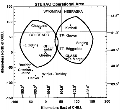
STERAO-A was conducted in Northeastern Colorado during June and July of 1996 with aircraft observations concentrated in a 4-week period from mid-June to mid-July. Colorado was chosen because of a high frequency of storms in the area ranging from simple air mass to multicell, to supercell thunderstorms; because it is close to Denver, CO, with suitable locations for aircraft operation; and because the Colorado State University (CSU) CHILL radar was located in the area near Greeley, CO. The Operations Center for the project was located in the radar control van at the CSU-CHILL radar site. During the 4-week period when aircraft were available, measurements were obtained in 14 storms with either one or both aircraft. The project also collected combined radar and lightning data daily from mid-June to early September, thus providing measurements on both intracloud (IC) and cloud-to-ground (CG) lightning for a wide variety of storm types of the central high plains.
STERAO-A closely coordinated chemical, dynamical, electrical, and microphysical observations to investigate the production of NOx by lightning, the transport and redistribution of chemical species in the troposphere by thunderstorms, and the temporal evolution of intracloud and cloud-to-ground lightning for evolving storms on the Colorado high plains. Major observations included airborne chemical measurements in the boundary layer, middle and upper troposphere, and thunderstorm anvils; airborne and ground-based Doppler radar measurements; measurement of both intracloud (IC) and cloud-to-ground (CG) lightning flash rates and locations; and multiparameter radar and in situ observations of microphysical structure. Cloud and mesoscale models were used to synthesize and extend the observations.
 |
SCIENTIFIC OBJECTIVES
A main objective of STERAO-A was to determine the effects of thunderstorms on the chemical structure of the middle and upper troposphere, particularly the production of NOx (= NO + NO2) by lightning and transport of NOx from the boundary layer. Subsequent effects on ozone was investigated in modeling studies. Another goal of the project is to relate the frequency and location of both intracloud and cloud-to-ground lightning to evolving reflectivity and airflow structure for storms of the Colorado high plains. This goal was important in its own right for understanding storm behavior and possible nowcasting applications, but was also is a critical component for the studies of NOx production by lightning. STERAO-A was successful in combining detailed chemical, electrical, kinematic, and microphysical measurements around thunderstorms and in thunderstorm anvils. STERAO provided information on the transport of chemical constituents from the boundary layer into the upper troposphere, the production of NOx by lightning, the lightning characteristics of evolving storms of the high plains, and some limited information on stratospheric-tropospheric exchange.
OBSERVATIONS
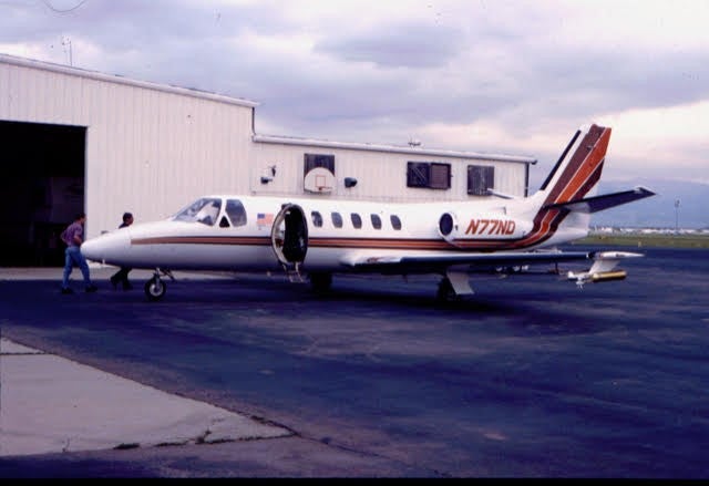
The major facility components of the project included: (1) the CSU-CHILL multiparameter Doppler radar, to observe the evolving storm structure; (2) a National Oceanic and Atmospheric Administration (NOAA) WP-3D Orion aircraft to characterize the chemical environment in which storms were growing, to determine the concentrations of constituents entering or exiting the storm in the boundary layer and mid-cloud levels, and to obtain Doppler radar measurements for deducing storm airflow patterns; (3) the University of North Dakota (UND) Citation jet aircraft to make chemical, airflow, and microphysical measurements in and around the anvils of the storms; (4) the French Office Nationale d'Etudes et de Recherches Aerospatiales (ONERA) three dimensional (3-D) lightning interferometer to determine total lightning flash rates and map lightning channels in the storms; (5) the National Lightning Detection Network (NLDN), to determine times and locations of cloud-to-ground lightning; and (6) the National Center for Atmospheric Research (NCAR) Atmospheric Technology Division mobile Cross-Chain Loran Atmospheric Sounding System (CLASS) for environmental soundings.
Two intercomparison (side-by-side leg) calibration flights were made with the WP-3D and Citation to compare chemical, thermodynamic, and wind measurements.
| Aircraft | NOAA WP-3D, UND Citation |
| Lightning | ONERA 3-D interferometer |
| Lightning | National Lightning Detection Network |
| Lightning | CSU fixed field change meters at the CHILL site and Fort Morgan airport; (1) mobile field change meter |
| Radar | CSU CHILL multiparameter Doppler Radar |
| Radar | NOAA WP-3D scanning X-band (3 cm) Doppler tail radar; lower fuselage C-band radar |
| Upper Air | NCAR CLASS Soundings from Fort Morgan, CO |
NETWORK MAP
 |
OPERATIONS
A climatological study of storms of northeastern Colorado during the National Hail Research Experiment (1972 -1976) showed a maximum frequency of occurrence around 1500 LT (2100 UTC), so operations were keyed to this approximate time. Daily weather briefings were held at 0900 LT in Boulder using facilities and forecast outputs of the NOAA Forecasting Systems Laboratory (FSL) and given by FSL or NOAA National Severe Storms Lab (NSSL) personnel. Additionally, the NCAR MM5 real-time model and the NASA Goddard/University of Maryland/State University of New York at Brockport 2-D cumulus ensemble model were used for guidance. Plans were made each morning for anticipated takeoffs of the WP-3D and Citation aircraft based on the forecast for deep convection coupled with a sense of previous climatology. Actual takeoffs were sometimes delayed when convective activity developed later than expected.
The WP-3D aircraft (with an endurance of >8 hours normally) took off about 1300 LT, a couple of hours before storms were anticipated, to map the chemical, thermodynamic, and dynamic pre-storm environment in the operational area. This consisted of flying roughly 100 km long north-south and then west-east flight legs starting at 150 to 200 m above the surface [~1700 m mean sea level (msl)]. These were followed by a continuous vertical spiral to about 7000 m msl and a stepped downward profile. When storms did form, the WP-3D was directed to the storm selected by the Operations Director at the Operations Center. After the WP-3D proceeded to the selected storm, it was flown about 15 to 20 km from and parallel to the long axis of the storm in a manner such that profiles of chemical constituents and Doppler radar measurements could both be obtained. The legs were incremented in altitude from near the surface to 7-8 km msl. When a storm was selected, the Citation (which has an endurance of about 3.5 hrs and a ceiling of roughly 12.5 km) was directed to take off and proceed to the anvil of the storm of interest. The ascent in route to the storm and descent upon return to base provided important vertical soundings of the environment and often were representative of the undisturbed environment. Complete soundings near the storms were not made because of the limited endurance of the aircraft. Upon reaching the storm the Citation made successive penetrations of the anvil incremented up or down in altitude. When possible, vertical spirals were made through the visible extent of the anvil. Radio communications to each aircraft were maintained from the CHILL operations near Greeley. Radar images, weather and satellite images, and real-time 2-D plots of total lightning activity from the ONERA lightning interferometer were all displayed in the operations center. Aircraft positions transmitted via phone line from the Federal Aviation Administration (FAA) were overlaid on the CHILL radar PPIs (plan position indicator sweeps). Thus, the Operations Director could identify and monitor storm location, motion, structure, and evolution, the presence of lightning within the storm, and locations of the aircraft relative to the storm and lightning. The real-time total lightning information from the interferometer proved to be particularly interesting because it identified new regions of active convection before the regions became clearly recognizable on radar.
Data Manager:
- EOL Archive NCAR/EOL/DMS