SESAME
Severe Environmental Storms and Mesoscale Experiment
During the spring of 1979, NSF, NOAA, NASA, other Governmental Agencies, and 14 Universities participated in a joint field project called the Severe Environmental Storms and Mesoscale Experiment (SESAME) to learn more about the structure, meso-synoptic processes, and dynamics of severe convective mesoscale systems. The NASA component was a continuation of a series of similar experiments, conducted during the years 1964-1978, under NASA’s Atmospheric Variability Experiment (AVE) Program. Three hourly regional scale rawinsonde data, along with other specialized data (e.g. aircraft, Doppler radar, satellite, surface, etc.) were collected during AVE-SESAME-79 to accomplish the scientific goals and further studies. These included: (1) the interaction of atmospheric scales of motion; (2) the structure and organization of mesoscale systems; and (3) developing a general understanding of parameterization for numerical, statistical studies, and prediction of severe convective weather. In particular, the phenomena associated with such severe convective activity included tornadoes, damaging winds, hail, floods, turbulence, etc., that affect property and personal safety. Two NCAR aircrafts, the QueenAir A-80, and the Sabreliner Model 60, flew missions to: (1) investigate the kinematic and thermodynamic structure of thunderstorm environments at low and mid-levels as represented by the thunderstorms of Oklahoma; and (2) explore the cross-sectional structure of the dry line through the use of a saw-tooth and stepladder pattern as well as to observe mixed layer development as associated with thunderstorms.
The regional-scale experiments consisted of 24-h periods of upper-air observation involving 23 National Weather Service (NWS) rawinsonde sites and 19 supplemental rawinsonde sites taking measurements at 3-h intervals during intensive observing or experiment periods. Rapid scan visual and infrared imagery was acquired by GOES satellites, along with TIROS-N and NIMBUS-G sensor data. Special conventional and special Doppler radar data were obtained from stations located in the experiment area. A dense special surface network of NCAR’s Portable Automated Mesonet (PAM) and NOAA’s National Severe Storm Laboratory (NSSL) Stationary Automated Mesonet (SAM) were located in central Oklahoma. In addition, special observations were made by a NOAA/NSSL storm electricity measurement site in Norman, OK, three (3) NSSL intercept photography teams, and volunteer observer reports.
OBSERVATIONS
| Aircraft | NCAR: Queen Air, Sabreliner |
|---|---|
| Aircraft | NASA: C-130, RB-57F, Lear Jet (Exp) |
| Aircraft | NOAA: Aerocom, Lear Jet |
| Aircraft | Air Force: F4C |
| Aircraft | South Dakota School of Mines & Technology: T-28 |
| Radar | NWS WSR-57 (both digital and photography) |
| Radar | NCAR Doppler CP-3, CP-4 |
| Radar | AFGL, CHILL, NOAA Cimarron, NRO |
| Satellite | GOES-3, SMS-2, TIROS-N, and NIMBUS-7, DMSP |
| Surface | Special automated mesonets: NCAR PAM, NOAA/NSSL SAM |
| Surface | 52 Cooperative Observer stations and volunteer observer reports |
| Upper Air | 42 NWS and special rawinsonde stations (regional-scale domain) |
| Upper Air | 20 supplemental rawinsonde stations (storm-scale domain) |
| Upper Air | Tethered balloon at Ft. Sill, OK |
NETWORK MAP
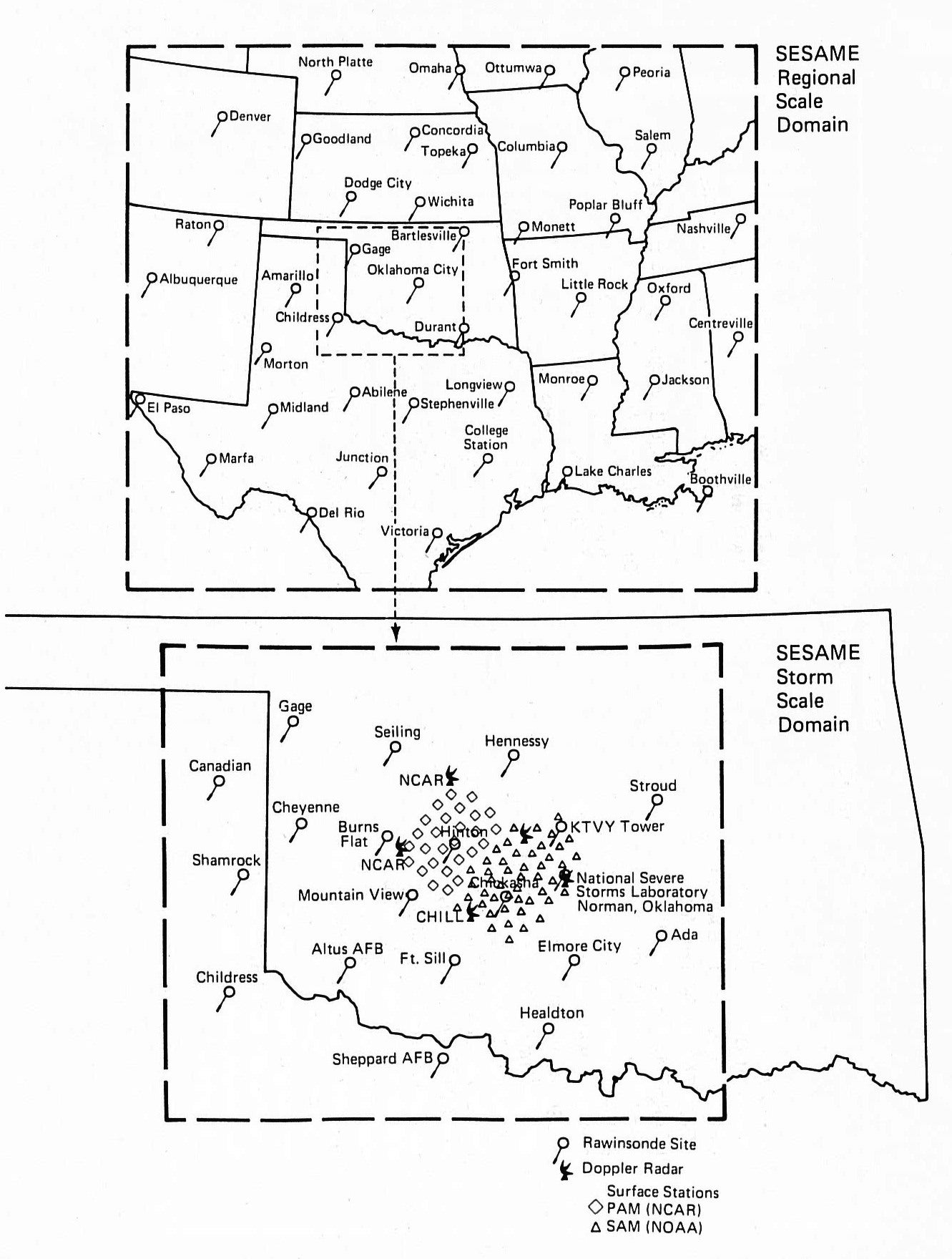 |
PROJECT OPERATIONS
SESAME Operations were highlighted by an extensive collection of mesoscale data from regional-scale and/or storm-scale rawinsonde networks on six separate days for 24-h periods. Regional-scale data collection took place on 10, 19, and 25 April, with approximately 350 soundings from 41-42 sites each day on a 3-hourly release schedule. The AVE days were designated for 9, 20 May and 7 June. For these cases, a 23 station regional-scale network enclosed a 20 station storm-scale network; both operated for 24-h on a release schedule similar to the regional-scale days. High-resolution satellite imagery days were conducted on 11 April; 2, 28, 30 May; and 5, 8, 15 June, for an overall total of 13 operational or experiment days during AVE-SESAME.
Other experiments were performed, which did not necessarily require thunderstorms. Boundary layer experiments were conducted in the Fort Sill, OK, area on the nights of 2, 4, 5, 6, and 8 May, to study the structure and development of the nocturnal jet. This study involved a tethered balloon site, instrumented aircraft, and rawinsonde support. On a number of different days, a study was done to correlate rainfall as sensed by Doppler radar and aircraft with that measured by a dense network of rain gauges. Pre-storm experiments were carried out involving Doppler radars, rawinsondes, and an aircraft, on at least two occasions (17 and 19 May). On two days (25 May and 4 June), a study was done to determine the kinematic and thermodynamic structure of dry convection in the boundary layer. These experiments involved multiple Doppler radars, several aircrafts, and rawinsondes. Three aircrafts carried out 18 precision approach experiments in order to compare the Norman, OK Doppler radial winds with aircraft winds along precision approach paths under various wind shear conditions.
Eight aircrafts had significant involvement in SESAME. An armored T-28 from the South Dakota School of Mining & Technology (SDSM&T) made 55-60 storm penetrations on 10 different days encountering updrafts on one occasion as high as 44 m/s and large hail on another. An Air Force F4C carried out 55-60 storm penetrations on 9 separate days in a study of storm turbulence. The NCAR Queen Air participated in experiments on 24 separate days flying in storm environments, penetrating Cumulus congestus clouds, fronts, and drylines, carrying out boundary layer experiments, and precision approach experiments. The NCAR Sabreliner carried out research flights on 11 separate days involving thunderstorm environment studies, drylines, fronts, boundary layer studies, and precision approach experiments. A Lear Jet (NOAA/NASA) carried out low-level wind shear and upper-level storm environment studies on 4 days. A NASA C-130 made air motion measurements in cloud fields for comparison with winds derived from satellite cloud tracking on 3 days. A NASA WB-57F and Lear Jet (Exp) made flights on 5 and 6 days respectively, measuring and photographing properties near the top of deep convective clouds.