NHRE
National Hail Research Experiment
The National Hail Research Experiment (NHRE) was conducted in the tri-state area of Colorado, Nebraska, and Wyoming, with the field headquarters located at Grover, Colorado. This area, during the three years prior to the start of NHRE, had been the site of the Joint Hail Research Project (JHRP), a cooperative study of hailstorms conducted by the Atmospheric Physics Laboratory of the National Oceanic and Atmospheric Administration (NOAA); Colorado State University (CSU); and NCAR. During the period of the JHRP, valuable knowledge was gained concerning local hailstorm statistics and climatology. This information was used in developing the plans for NHRE.
|
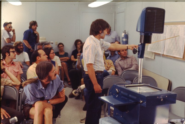
NHRE staff meeting, undated.
|
 |
The NHRE field deployments were conducted during the summer months from 1971 through 1976. The first year was devoted to completing the field headquarters complex and evaluating new equipment and operational procedures. The randomized seeding experiment was conducted during the hail seasons from 1972 through 1974 along with a concurrent research program. The objective of the research program was "to gain an increased understanding of all aspects of the cloud dynamics and microphysics governing severe convective storms that produce damaging hailfall at the ground". During 1975, a small-scale field deployment was conducted to test and evaluate new and improved observational systems and to collect research data, if and when, these systems became operational. An extensive field program was conducted during the summer of 1976; the final field deployment of NHRE. During the field deployments from 1972 through 1976, observations were made on 308 days. From this total, 65 case study days were selected for future research.
Other contributions to the field observation deployments and research efforts were made by the University of Arizona, University of Chicago, Clemson University, University of Colorado, CSU, University of Denver, University of Hawaii, University of Illinois, Illinois State Water Survey (ISWS), Metropolitan State College, University of Nevada, University of Oklahoma, Oregon State University, Panhandle State University, South Dakota School of Mines and Technology (SDSM&T), University of Virginia, University of Wisconsin, and University of Wyoming (UW). Government agencies providing support included: U.S. Air Force, Air Weather Service; U.S. Navy, Naval Electronics Laboratory, Weapons Development Center, Naval Weather Service; U.S. Army, White Sands Proving Grounds; Federal Aviation Administration (FAA); and the Wave Propagation and Atmospheric Physics and Chemistry Laboratories of the NOAA. Private industry was represented by Atmospherics Inc., Battelle Northwest Laboratories, Human Ecology Research Services, Inc., and Western Scientific Services, Inc.
 |
.jpg) |
|
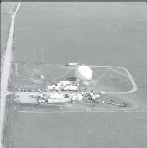
Aerial view of the NHRE research site, undated.
|
Hail researchers watch radiosonde ascend, 1976.
|
EXPERIMENTAL GOALS
Early in the development of the operational plans for the NHRE, it was decided that the experimental area must meet certain minimum requirements: (1) be in a region of high frequency of hailstorms, with modest year-to-year variance; (2) have fairly level and uniform terrain so that the incidence of hailstorms is not too adversely affected by local orographic or thermal effects, allowing estimates of surface air convergence from measured winds to be made with confidence; (3) have a good road network to afford easy access to network sites and mobility for the precipitation sampling crews; and (4) not underlie air traffic of such high density that release of the area by the Federal Aviation Administration (FAA) during operational periods would be unobtainable.
|
NHRE experiment tower at New Raymer, undated.
|
.jpg) |
The research objective for 1972 was "to gain an increased understanding of all aspects of the cloud dynamics and microphysics governing severe convective storms that produce damaging hailfall at the ground." The research program developed in response to this objective was considered to be of importance for the following two reasons:
- The economic feasibility of hail suppression rests heavily on the ability to forecast hailstorms reliably. A study of the synoptic and mesoscale environment in which hailstorms evolve, oriented toward better techniques of forecasting, is essential to this end.
- The numerical modeling of thunderstorm processes without supporting observational data is a slow and uncertain exercise. In an effort to improve the progress in this area, the research program was oriented toward first providing greatly lacking data on cloud variables to modelers and second, providing opportunities for the modelers to test their predictions against field observations of real thunderstorms.
Based on the above objective the goal of the 1972 field season was to conduct intensive studies of isolated "single cell" storms. In terms of operational procedures, it was intended to concentrate all measurement systems simultaneously on the same storm, observing it through its life cycle.
The research objectives for 1973 and 1974 were similar to that of 1972. The "complete" research day concept was continued. Additional studies included a study of the possible downwind effect of the seeding operations by CSU; a study by CSU of possible silver iodide contamination of soil, vegetation, and water; a study of silver iodide concentrations in precipitation at stations within the area by DRI; and a study of the fine structure of hailfall on the ground within a one-square-mile area, densely instrumented, carried out by the ISWS.
The main goal of the 1975 deployment was to test new and modified equipment under actual weather conditions. The specific objectives were: (1) Conduct an operational test and evaluate new and improved observational systems; and (2) Collect research data if and when essential observational systems were operational.
The approach used during the 1976 field observation program was coordinated, multiple-aircraft storm penetrations, and cloud base measurements, in conjunction with conventional and Doppler radar observations. The objectives included: (1) Identifying the location and microphysical structure of embryo
growth regions (particularly "first radar echo" regions); (2) Determining the trajectories of hailstones and their growth environments; and (3) Determining the dynamical structure and evolution of the storm. Two additional objectives, not directly related to the above, were also conducted. The first (Initiation of Precipitation) was designed to assess the feasibility of on-top seeding and the second (Mature Storm Study) continued the observation of hailfall parameters and their relation to crop damage.
The 1977 program was focused on analysis and interpretation of the data collected during the 1976 field deployment. No special field data were collected, other than continuing the crop damage studies related to hailfall characteristics.
The 1978 field deployment (1-31 July) focused on studying the early phases of storm development and the processes by which rain and hail form in cloud turrets in convective storms. No cloud seeding was performed, but three (3) aircraft (i.e. NCAR/NOAA “Explorer” Sailplane, SDSM&T T-28, and the UW Queen Air) were used to make measurements inside clouds. Two other NCAR Queen Airs were used to photograph the clouds and to make measurements in the region below cloud base. Four (4) special surface stations were deployed and rawinsonde measurements were released from the Grover field site. NCAR operated two (2) radars at Grover, and NOAA operated a Lidar at Grover and two (2) Doppler radars (one east of Grover, CO, and one north of Carpenter, WY).
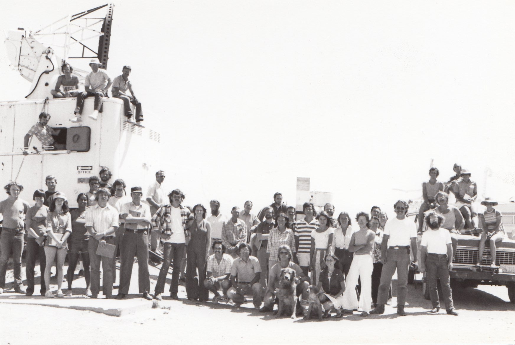 |
| Group Staff Photo taken at Grover, CO, Summer 1976 |
OBSERVATIONS/DATA
The scientific radars deployed during 1972 (15 April through 29 July) included dual-wavelength radars from NCAR, the University of Chicago, and University of Illinois (CHILL). An M33 radar from the University of Nevada's Desert Research Institute (DRI) was used for areal surveillance and tracking research aircraft. Aircraft participating in the 1972 field program included the CSU F-lOlB; the UW Queen Air; the NCAR Buffalo, Sabreliner, and Queen Air; the NOAA DC-6 and C-130; the SDSM&T armored T-28; and four seeding aircraft from Atmospherics Incorporated (AI). Surface Mesometeorological and Upper Air Rawinsonde sites were deployed in the target area, with precipitation samples were collected by mobile teams from the UW and NCAR.
.jpg) |
|
Assembly of antenna, undated.
|
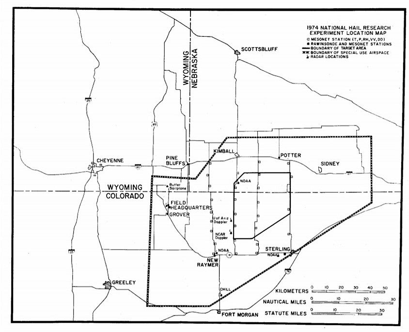
The operational/target areas for the 1973 (16 April through 31 July) and 1974 (13 May through 9 August) deployments were altered somewhat after the 1972 season when it was shifted northward to be centrally located within the expanded airspace. A network of 5 rawinsonde, 33 surface meteorological, and 370 precipitation stations were deployed. The aircraft that participated in the 1973 field season included the UW Queen Air, the SDSM&T armored T-28, the NCAR Sabreliner and two Queen Airs, the NOAA/NCAR sailplane, and five Piper Aztec seeding aircraft from AI. During the 1974 season the number of research aircraft was reduced, with only the NCAR Sabreliner and Queen Airs and the NOAA/NCAR sailplane being available for meteorological observations. The University of Arizona provided a vertically pointing X-band Doppler radar and NCAR provided a vertically pointing C-band radar.
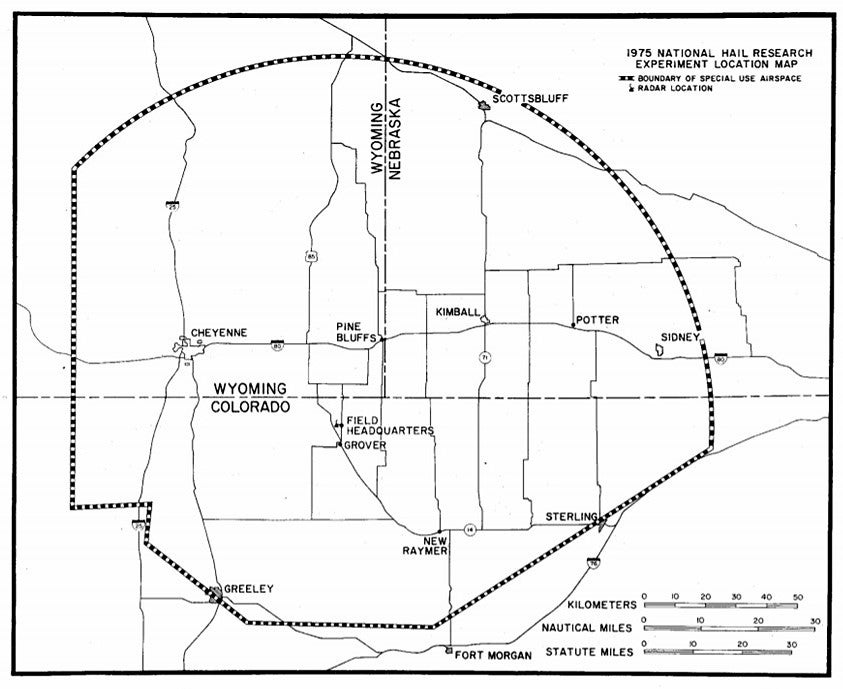
In 1973, the number of mobile precipitation sampling teams was increased with the addition of two crews from DRI. Also, 1973 was the first year during which the cooperative hail crop network (and crop damage appraisal program) of NCAR's Environmental and Societal Impacts Group (ESIG) was operated. 114 Hailpads and hailcubes (over an area of 2.6 sq km) were included in the target area. In 1974, the mobile sampling was conducted by four teams, three from DRI and one from NCAR. During 1975 (July), the level of field activity was considerably less than in the previous years. The main objective of the field program was shifted to test improved instrumentation. The major observing systems were the NCAR dual-wavelength radar, the DRI surveillance and aircraft tracking radars, the SDSM&T armored T-28, and two NCAR mobile precipitation sampling crews.
.jpg) |
|
NOAA/NCAR Sailplane (N9929J), undated.
|
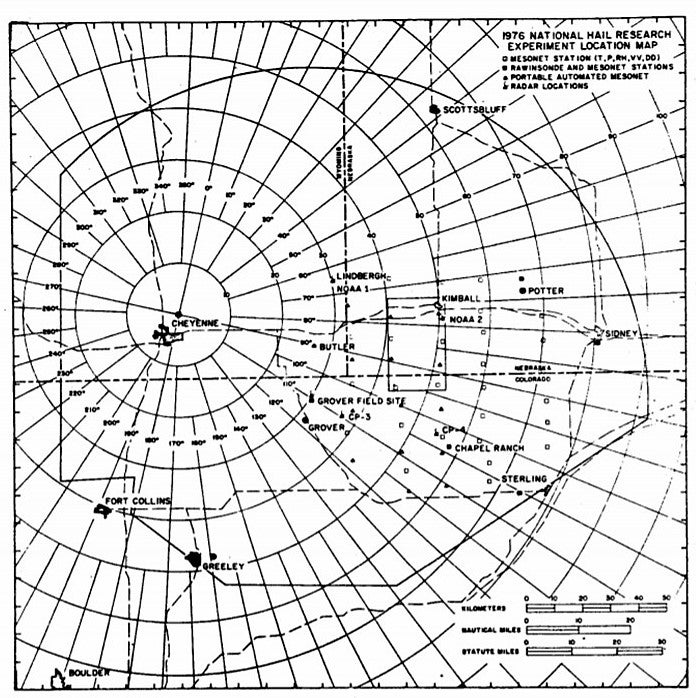
The 1976 deployment (18 May through 1 June) operating area and special-use airspace was expanded west and north. The number of mesometeorological stations was increased to 45 through the implementation of the NCAR Portable Automated Mesometeorological (PAM) network. During 1976, a dense network of hailpads, hailcubes, and rain gauges were deployed and scientific radars included the NCAR dual-wavelength radar and four Doppler radars (two X-band radars from NOAA and two NCAR C-band radars. The DRI M33 surveillance and aircraft-tracking radars were once again located at the Grover field site. Research aircraft included the UW Queen Air, the SDSM&T armored T-28, the NOAA/NCAR sailplane, and the NCAR Sabreliner and Queen Airs. Precipitation samples were collected by four mobile teams, two each from the UW and NCAR. In addition, two fixed aerosol sampling sites were established. One was located eight miles north of Stoneham, CO, and was operated by NCAR. The second was located near the Sidney, NE airport and was operated by the UW.
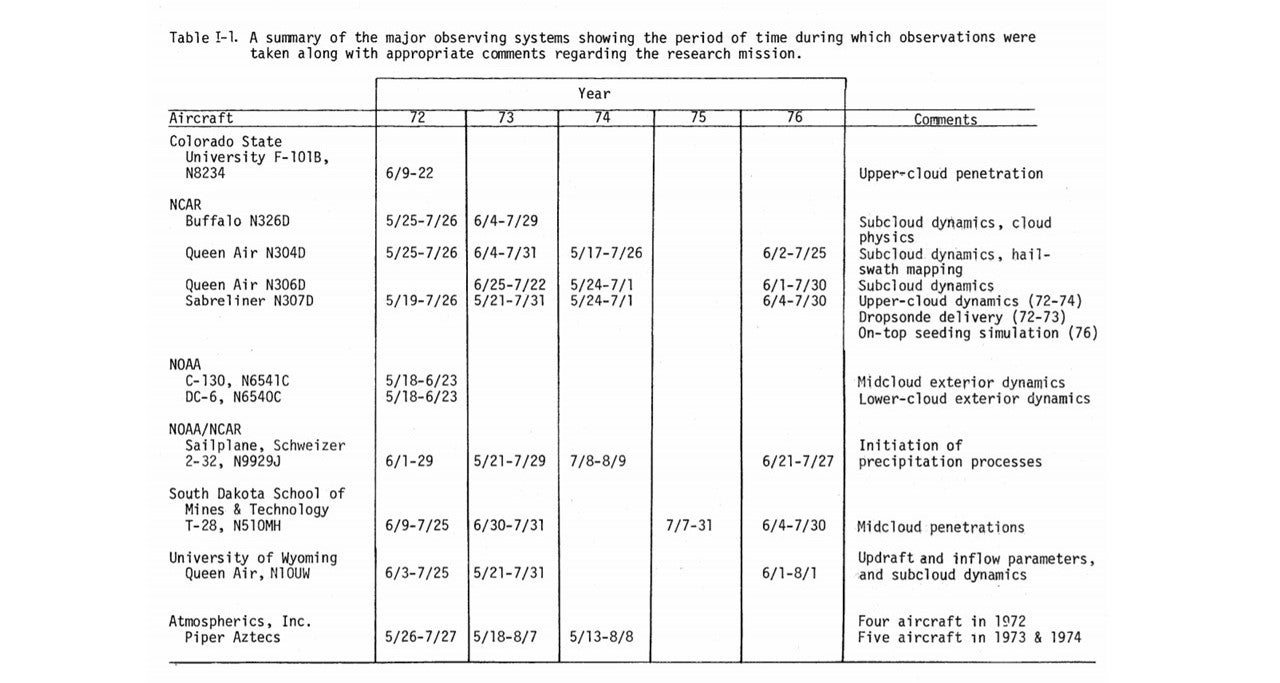
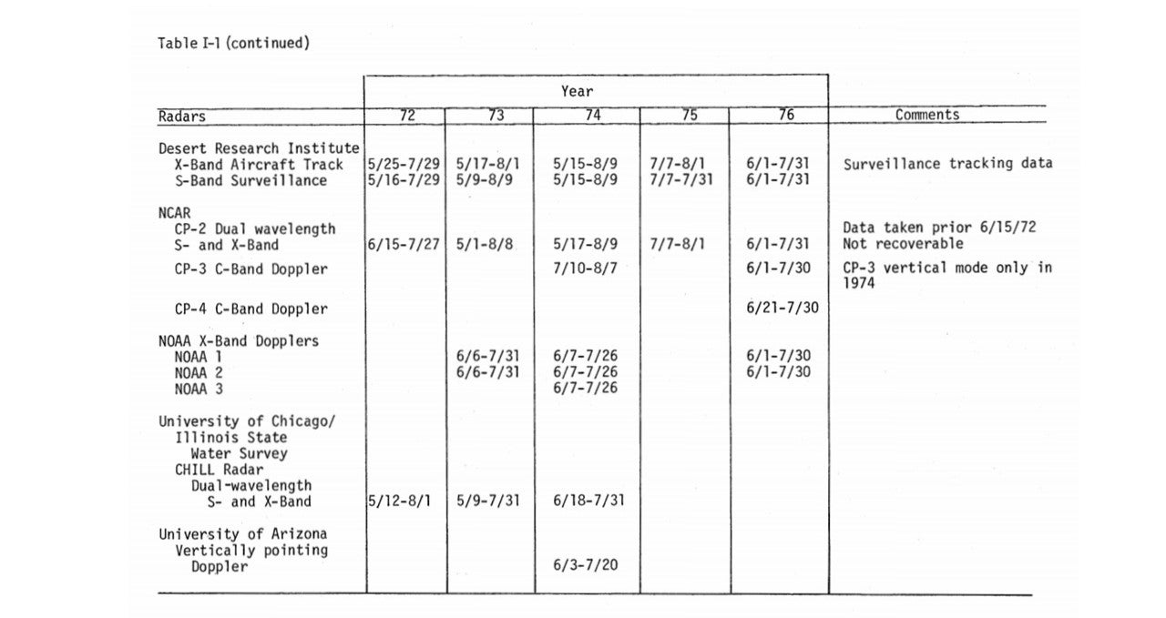
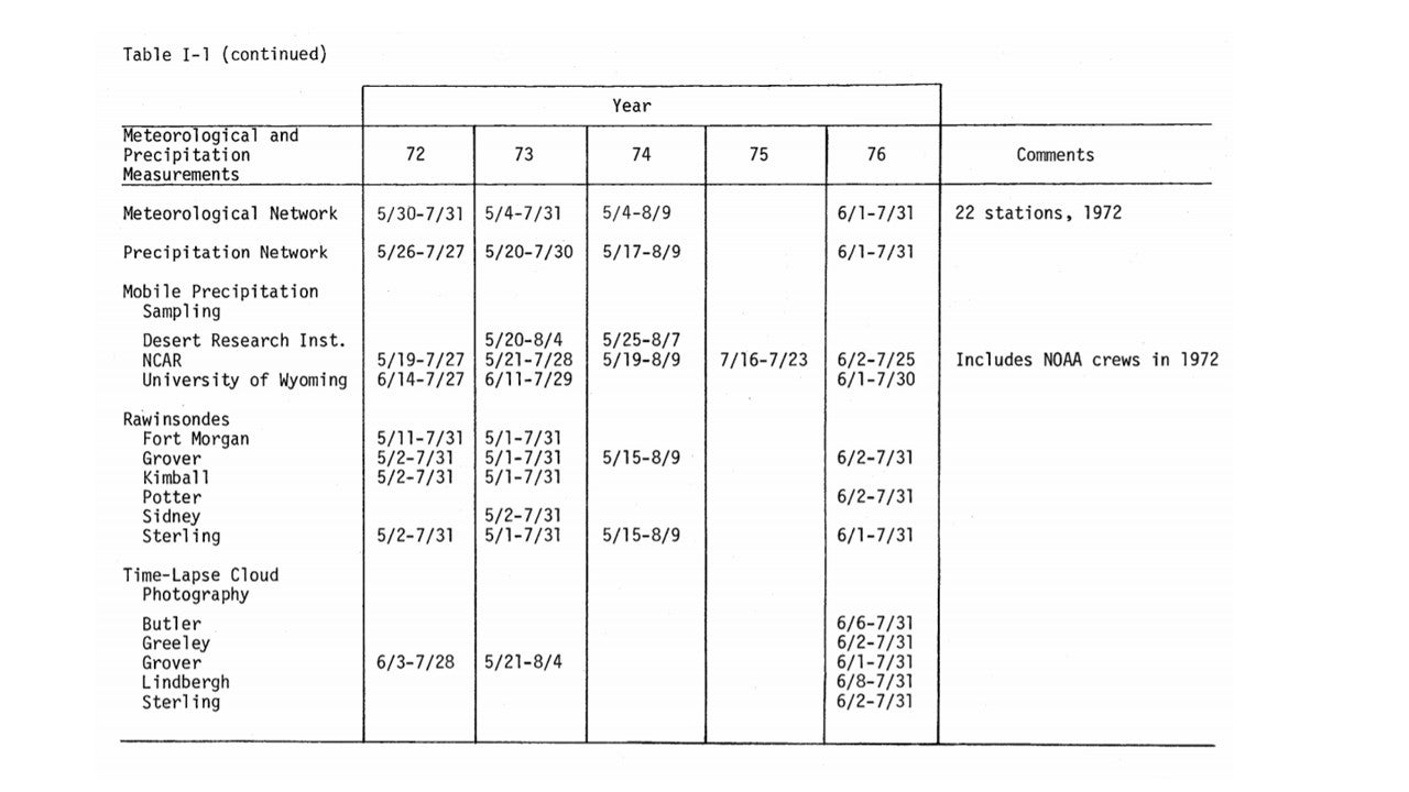
A summary of the observing systems (and data collection) for all years, 1972 through 1976, is summarized below. The table is divided into three parts which summarize the instrumentation by three major categories: aircraft, radar, and meteorological and precipitation measurements. The observing systems and the period of time during which observations were taken are shown for each category. Please click images for full resolution.
 |
 |
 |
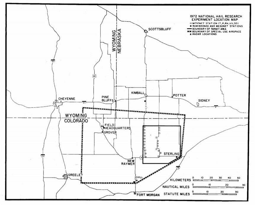
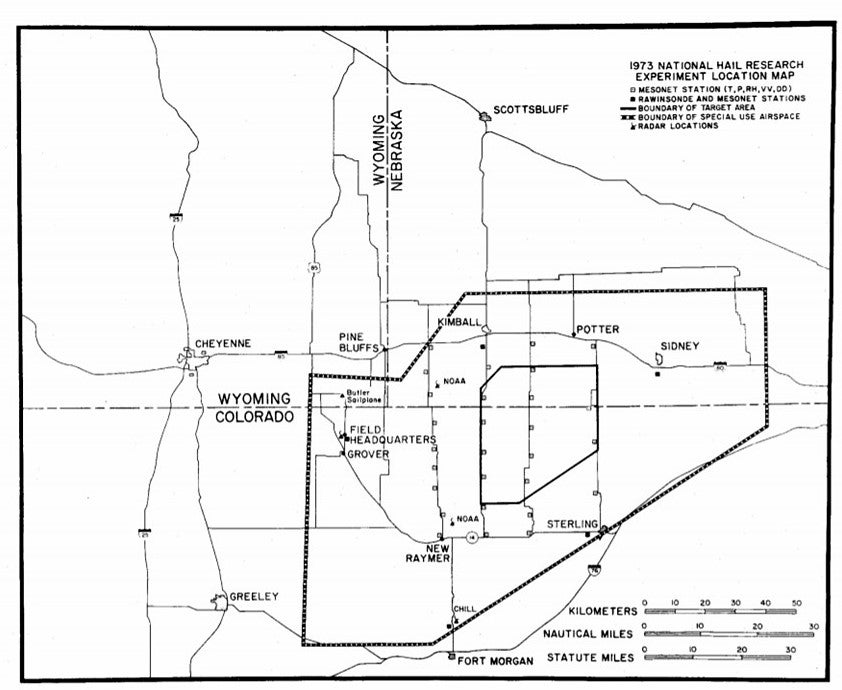
NETWORK MAPS
NHRE Field Deployment Network Maps are shown by individual years. On these field deployment maps, the heavy dashed lines identify the FAA-assigned special-use airspace. The target area is shown by the solid interior boundary. The open squares identify the mesometeorological network sites while dark squares show the collocations of mesometeorological and rawinsonde observations. Radar locations are shown by the radar icons. The major portion of the precipitation, measuring instruments were located within the boundaries of the target area. Please click images for full resolution.
| 1972 | 1973 |
 |
 |
| 1974 | 1975 |
 |
 |
| 1976 | 1978 |
 |
.png) |
All photos copyright University Corporation for Atmospheric Research unless otherwise noted.