NDTE
North Dakota Tracer Experiment
Western North Dakota is one of the permanent high hail incidence areas in the upper Great Plains and Midwestern United States due to synoptic-scale factors including high frequencies of cyclone and cold front passages in the summer. North Dakota has also historically had among the highest crop-hail insurance loss costs in the United States. Interest in hail suppression and rainfall augmentation has driven operational weather modification efforts in North Dakota for over three decades.
The need to explore and document these processes was recognized, and in 1978 the National Oceanic and Atmospheric Administration’s (NOAA’s) Federal-State Cooperative Program in Weather Modification Research, later known as the NOAA Atmospheric Modification Program (NOAA/AMP) was born. Through this initial funding, the North Dakota Atmospheric Resource Board (ARB) began to coordinate efforts aimed at addressing the uncertainties of their operational seeding program, starting with the transport of seeding agent from the release aircraft into updrafts encountered below rain-free cloud bases. Early on it was decided that a "chain of events" approach would be taken, in which each step in the seeding process would be identified and experimentally examined to test the operational methodology. The data collection efforts began with instrumented aircraft, radars, and other equipment sampling clouds in a brief 1984 field program. Follow-on investigations were conducted in 1985, and on significantly larger scales in 1987, and 1989 (the North Dakota Thunderstorm Project or NDTP), which lead to the design and implementation of this follow-on 1993 North Dakota Tracer Experiment (NDTE).
NDTE Participants included the Canadian Atmospheric Environmental Service (AES), North Dakota Atmospheric Research Board (ARB), Colorado State University (CSU), National Aeronautics and Space Administration (NASA) Goddard Space Flight Center (GSFC), National Center for Atmospheric Research (NCAR), North Dakota State University (NDSU), NOAA Environmental Technologies Laboratories (ETL), University of North Dakota (UND), South Dakota School of Mines and Technology (SDSMT), and Weather Modification Incorporated (WMI).
SCIENTIFIC OBJECTIVES
The Long-term goals of the NDTE were to: (1) Determine and quantify the physical processes that lead to the development of rainfall in the northern Great Plains convective clouds; (2) Determine the physical processes which result in the production of hail, and develop means to predict hail formation a priori; (3) Improve the understanding and predictability of weather hazards including damaging winds and cloud-to-ground lightning on the northern Great Plains; and (4) Determine the feasibility of significantly altering the hail and precipitation formation processes towards improved agricultural productivity.
Short-term goals included: (1) Determine the cloud-scale transport, dispersion, entrainment, and mixing processes in High Plains cumulus and cumulonimbus clouds; (2) Determine whether glaciogenic seeding agents, as applied in the ongoing county-sponsored operational cloud seeding project, reach and fill the targeted (supercooled) portion of the treated cloud; (3) Determine the dominant primary ice initiation mechanism(s) in northern High Plains cumuliform clouds; (4) Determine what concentrations of artificial ice nuclei are required to significantly influence the precipitation process; (5) Employ appropriate cloud models to simulate seeded and non-seeded cloud conditions, and compare the results of the simulations to: a) observations of similar real clouds, and b) the expected cloud behavior based on the seeding conceptual models; (6) Apply in situ aircraft, tracer, radar, and other data to verify various aspects of the cloud models; (7) Examine the effects of seeding on cloud-to-ground lightning production in and out of operational seeding target areas; (8) Conduct preliminary assessments of benefits accrued from seeding in North Dakota; (9) Determine the relation of cloud transport, glaciation, and precipitation processes to cloud structure, organization, and life cycle using radar, satellite, aircraft, and other observations in conjunction with numerical simulations; (10) Characterize norther Great Plains atmospheric aerosols (cloud condensation nuclei and ice nuclei) which influence cloud processes near the surface and aloft; and (11) Identify the conditions and circumstances under which warm-cloud precipitation processes are important in northern Great Plains convective clouds.
A total of fourteen (14) Experiments were conducted during the NDTE including: Aircraft and Radar (11), Numerical modeling forecasting (2), and Atmospheric aerosol measurements (1). The experiments were designed to gather detailed microphysical information (in-situ aircraft sampling), afford in-cloud tracing capability (SF6 detection), reveal detailed cloud structure (radar reflectivity data) and internal cloud motions (Doppler velocity data, sometimes coordinated dual-Doppler scanning), and provide cloud-scale transport information. The dual-circularly-polarized NOAA radar can differentiate between echoes resulting from chaff and meteorological echoes through the use of the circular depolarization ratio (CDR), a technique dubbed TRACIR, for TRacking of Air with CIrcularly-polarized Radar.
OBSERVATIONS/DATA
| Aircraft | UND Cessna Citation II; SDSMT T-28; WMI Beechcraft Duke |
|---|---|
| Lightning | National Lightning Detection Network |
| Radar | NOAA/ETL X-band Doppler radar; UND C-band Doppler radar |
| Surface | CSU Aerosol (IN and CCN measurements) Samplers |
| Surface | North Dakota Agricultural Weather Network (UND and NDSU) |
| Surface | North Dakota Cooperative Raingauge Network |
| Surface | National Weather Service synoptic weather Stations |
| Upper Air | NCAR CLASS mobile sounding system |
| Upper Air | National Weather Service Regional Rawinsonde Stations |
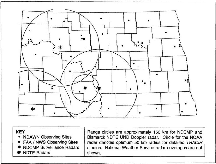
Regional surface weather data were recorded by the North Dakota Agricultural Weather Network (NDAWN), operated by North Dakota State University and the UND Aerospace Department. A 900-member statewide volunteer network (not shown on the Network map) was maintained by the ARB which recorded daily precipitation and hail reports.
NETWORK MAP
 |
PROJECT OPERATIONS
Research efforts were directed from the NDTE Operations Center (NOC) collocated with the NDTE aircraft and UND Doppler radar at the Bismarck, ND, Airport. The UND radar was controlled from the NOC through a fiber-optic link to the radar van. In addition to the radar reflectivity and Doppler velocity displays, the Operations Center contained the ARB’s MclDAS workstation; the NLDN lightning display station; VHF and FM radio links to project aircraft and the NOAA radar (deployed 50 km west of the NOC), respectively; direct radio downlinks from the project aircraft; and an AES workstation with software for a variety of forecasting/nowcasting tasks, including sounding analysis. A numerical modeling workstation which accessed an NCAR Cray supercomputer to run the SDSMT two-dimensional, time-dependent cloud model; and another which accessed either the UND Aerospace Cray or the Goddard Space Flight Center Cray (depending on which was affording better speed) to run the NASA Goddard Cumulus Ensemble (GCE) cloud model through Internet connections via the UND System.
Aircraft positions reported by on board GPS (Global Positioning System) receivers were telemetered to the NOC, processed into the radar data stream, and displayed in real-time on the PPI’s as they were refreshed. Within the NOC, activities were coordinated by an Operations Director (OD), Storm Intercept Coordinator, Aircraft Coordinator, Forecast/Nowcast Team, and Radar Coordinator. A Research Experience for Undergraduates (REU) program, sponsored by the National Science Foundation (NSF), allowed students from universities nationwide to participate in the NDTE field effort.
Some improvements over earlier North Dakota field programs included simultaneous release of radar chaff and SF6 from the same aircraft, aircraft tracking by GPS rather than from FAA flight tracks, real-time downlinking of aircraft positions directly to the Operations Center, and real-time display of the Duke tracer release aircraft position relative to the Citation tracer detection aircraft within the cockpit of the detection aircraft. Atmospheric aerosols were sampled from the NOC, and aerosol samples collected aloft by the UND Citation were processed immediately after each flight, affording some quantitative feel for storm precipitation efficiency and ice nucleus and cloud condensation nucleus concentrations. The NDTE also employed the NCAR mobile Cross-chain Loran Atmospheric Sounding System (CLASS) to obtain soundings in the vicinity of the subject cloud complexes.
Further information and details on NDTE can be found at NDTE_overview.pdf.