Barbados Experiment 1968
Barbados Experiment 1968
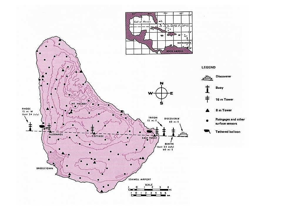
The 1968 Barbados Experiment was a meteorological field program under the direction of Dr. Garstang (Florida State University) with participation by the U.S. Navy, Army, Air Force; Air National Guard; NCAR; the Sea-Air Interaction Laboratory; the Experimental Meteorology Branch of ESSA; the Barbados Government; the Institute for Tropical Meteorology; and several Universities (Colorado State, McGill, Wisconsin). Field operations were conducted from 5 July to 7 September 1968, sub divided into 2 periods (12 July to 1 August, and 5 August to 30 August). Each period had 3 days of intensive observations (with all systems functioning at peak capacity) followed by 2 days of routine observations. Each period closed with 5 days of intensive data gathering. Data were obtained along an east-west baseline extending 60 miles east of Barbados to 15 miles west of the island. The easternmost point of the baseline was occupied by the CGSS Discoverer and an oceanographic buoy. Other baseline stations were buoys and island towers. Radar, balloons, and aircraft (NCAR Queen Air) extended the observations outward and upward (see Network Map). NASA’s ATS-3 geosynchronous satellite provided regional photographic coverage relating the Barbados area to the entire Atlantic-Caribbean region. A total of 94 research flights were flown by the NCAR Queen Air.
SCIENTIFIC OBJECTIVES
The overall scientific objective of studying interacting scales of motion within a limited region of the maritime tropics (specifically the Barbados area) was focused in the following areas:
Air-Sea Interaction Program: (1) obtain simultaneous quantitative measurements of the flux of momentum, water vapor, and sensible heat by a number of independent methods under steady and unsteady atmospheric and oceanic states; (2) delineate meso (10 to 100 km), convective (1 to 10 km), and turbulent (< 1 km) scales of motion and place these implicitly within the framework of the synoptic (100 to 1000 km) and planetary (> 1000 km) scales of motion; (3) investigate the interdependence of energy fluxes and the various scales of motion and via simultaneous measurements of fluxes obtain quantitative intercomparison and determination of absolute magnitudes of the fluxes under these different degrees of organization in the tropical atmosphere; and (4) study variations of oceanographic surface parameters (in particular sea state and wave fields) in relation to meteorological parameters and various fluxes.
Land-Sea-Air Interaction Program: (1) determine the differences between oceanic and island conditions leading to the intercomparison of frictional and heating effects at sea-land boundaries, intercomparisons of land and sea based techniques of flux determination and the representation of oceanic conditions via land based observations; (2) examine in detail the effects of an island obstacle and heat-cold source upon the flow of the atmosphere as an example of forced convection and meso-scale organization and the development of a numerical model representing these processes; and (3) examine the radiative balance at the surface of the island and over the open ocean and to determine for the island the radiative flux divergence in the boundary layer.
Atmospheric Program: (1) depiction of the vertical structure (kinematic and thermodynamic) of the tropical atmosphere. The relationship between changes in this vertical structure to changes in the energy flux at the lower boundary as well as the changes in the convective, meso, and synoptic scale organization; (2) the possibility of parameterization of the energy flux in terms other than air-sea property differences, specifically the evaluation of satellite photography of cloud distributions, concurrent aircraft and surface observations (ship and island); (3) the development of a numerical model to depict the structure of the tropical atmosphere based upon the input at the lower boundary and the vertical and horizontal fluxes; (4) the interrelationship between the equatorial trough (or inter-tropical convergence zone), the mid-Atlantic trough as planetary features and synoptic and meso-scale organization in the tropical atmosphere; and (5) the determination of radiative flux through the atmospheric column and the radiative heating of specific layers with particular emphasis upon the boundary layer and the layer immediately below the tropopause.
OBSERVATIONS
| Aircraft | NCAR Queen Air, U.S. Navy and Air Force weather reconnaissance flights |
|---|---|
| Oceanographic | 3 instrumented buoys, Routine Meteorological and oceanographic measurements from Ship |
| Radar | 2 U.S. Army M-33 Radar systems |
| Ship | CGSS Discoverer |
| Surface | 14 eight-meter towers, 3 sixteen-meter towers, NCAR aerosol sampling stations |
| Surface | 92 Existing routine Barbados raingauge and meteorological observing stations |
| Upper Air | 2 Tethered balloons, tethered parafoil kites |
| Upper Air | 250 Sounding balloons released from the CGSS Discoverer |
| Upper Air | 177 constant-level balloons launched by aircraft or land |
| Upper Air | 1 U.S. Army GMD-1B Rawinsonde system |
NETWORK MAP
 |
Click Image for Full Resolution
- EOL Archive NCAR/EOL/DMS