Below is a list of highlighted publications selected by the EOL Science Group and the EOL Directors Office. These include papers considered and nominated for the UCAR Outstanding Publication award, plus other papers chosen to represent a cross-section of the wide range of research carried out in EOL. This list is under revision, and please visit again soon. A complete list of EOL publications is available on OpenSky.
STEPHENS ET.AL., 2018:
The O2/N2 ratio and CO2 airborne Southern Ocean study (ORCAS)
Bulletin of the American Meteorological Society, 99, 381–402
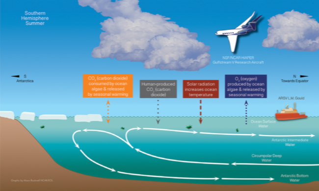 Abstract. The Southern Ocean plays a critical role in the global climate system by mediating atmosphere-ocean partitioning of heat and carbon dioxide. However, Earth system models are demonstrably deficient in the Southern Ocean, leading to large uncertainties in future air-sea CO2 flux projections under climate warming and incomplete interpretations of natural variability on interannual to geologic time scales. Here, we describe a recent aircraft observational campaign, the O-2/N-2 Ratio and CO2 Airborne Southern Ocean (ORCAS) study, which collected measurements over the Southern Ocean during January and February 2016. The primary research objective of the ORCAS campaign was to improve observational constraints on the seasonal exchange of atmospheric carbon dioxide and oxygen with the Southern Ocean. The campaign also included measurements of anthropogenic and marine biogenic reactive gases; high-resolution, hyperspectral ocean color imaging of the ocean surface; and microphysical data relevant for understanding and modeling cloud processes [...]
Citation: Stephens, B.B., M.C. Long, R.F. Keeling, E.A. Kort, C. Sweeney, E.C. Apel, E.L. Atlas, S. Beaton, J.D. Bent, N.J. Blake, J.F. Bresch, J. Casey, B.C. Daube, M. Diao, E. Diaz, H. Dierssen, V. Donets, B. Gao, M. Gierach, R. Green, J. Haag, M. Hayman, A.J. Hills, M.S. Hoecker-Martínez, S.B. Honomichl, R.S. Hornbrook, J.B. Jensen, R. Li, I. McCubbin, K. McKain, E.J. Morgan, S. Nolte, J.G. Powers, B. Rainwater, K. Randolph, M. Reeves, S.M. Schauffler, K. Smith, M. Smith, J. Stith, G. Stossmeister, D.W. Toohey, and A.S. Watt, 2018: The O2/N2 Ratio and CO2 Airborne Southern Ocean Study. Bull. Amer. Meteor. Soc., 99, 381–402, doi: 10.1175/BAMS-D-16-0206.1
JENSEN AND NUGENT, 2017:
Condensational Growth of Drops Formed on Giant Sea-Salt Aerosol Particles;
Journal of Atmospheric Science, 72, 4755-4776.
 Abstract: The most basic aspect of cloud formation is condensational growth onto cloud condensation nuclei (CCN). As such, condensational growth of cloud drops is often assumed to be a well-understood process described by the drop growth equation. When this process is represented in models, CCN activate into cloud drops at cloud base, and it is often assumed that drops consist of pure water or that the hygroscopic contribution after drop activation is small because of the inclusion of only small CCN. Drop growth rate in adiabatic ascent in such models is proportional to supersaturation and assumed to be inversely proportional to the drop radius, thereby making the drop spectrum narrow with altitude. However, the present study demonstrates that drop growth on giant sea-salt aerosol particles (GCCN; dry radius 0.5 m) behaves differently. [...]
Citation: Jensen, J.B. and A.D. Nugent, 2017: Condensational Growth of Drops Formed on Giant Sea-Salt Aerosol Particles. J. Atmos. Sci., 74, 679–697, doi: 10.1175/JAS-D-15-0370.1
Avallone and Baeuerle, 2016:
A 20-year history of NSF-supported atmospheric science field campaigns: statistics and demographics
Bulletin of the American Meteorological Society, 98, 1333–1339.
 Abstract. Over the past two decades, the National Science Foundation’s (NSF) Division of Atmospheric and Geospace Sciences (AGS) has funded nearly 200 atmospheric science-related field campaigns that have included deployment of AGS-sponsored observing facilities. These projects have spanned the range from modest, single investigator experiments to massive, multi-investigator, multi-agency campaigns. They have occurred both domestically and abroad, on every continent and over most oceans. In this article, we present an analysis of some of the details about these campaigns, including such elements as deployment location and cost of the campaign, and of statistics related to the principal investigators (for example, type and location of institution, gender, years since degree). In addition, we assess trends in field campaign cost. These results provide a retrospective view of atmospheric science field work that has been supported since 1992.
Linnea M. Avallone and Brigitte Baeuerle1 Division of Atmospheric and Geospace Sciences, National Science Foundation2 Earth Observing Laboratory, National Center for Atmospheric Research, 0: A 20-year history of NSF-supported atmospheric science field campaigns: statistics and demographics. Bull. Amer. Meteor. Soc., 0, doi: 10.1175/BAMS-D-15-00222.1.
Grubišić, et. al., 2015:
Atmospheric wake of Madeira: First aerial observations and numerical simulations
Journal of Atmospheric Science, 72, 4755-4776.
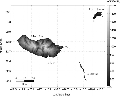 Abstract. The island of Madeira is well known for giving rise to atmospheric wakes. Strong and unsteady atmospheric wakes, resembling a von Kármán vortex street, are frequently observed in satellite images leeward of Madeira, especially during summer months, when conditions favoring the formation of atmospheric wakes occur frequently under the influence of the Azores high.
Reported here is the analysis of the first airborne measurements of Madeira’s wake collected during the 2010 Island-induced Wake (I-WAKE) campaign. High-resolution in situ and remote sensing data were collected in the I-WAKE by a research aircraft. The measurements reveal distinctive wake signatures, including strong lateral wind shear zones and warm and dry eddies downwind of the island. A strong anticorrelation of the horizontal wind speed and sea surface temperature (SST) was found within the wake. [...]
Citation: Grubišić, V., J. Sachsperger, and R. Caldeira,: Atmospheric wake of Madeira: First aerial observations and numerical simulations. J. Atmos. Sci., 72, 4755-4776, doi: 10.1175/JAS-D-14-0251.1, 2015.
Spuler, et. al., 2015:
Field-deployable diode-laser-based differential absorption lidar (DIAL) for profiling water vapor
Atmospheric Measurement Techniques, 8, 1073-1087.
 Abstract. A field-deployable water vapor profiling instrument that builds on the foundation of the preceding generations of diode-laser-based differential absorption lidar (DIAL) laboratory prototypes was constructed and tested. Significant advances are discussed, including a unique shared telescope design that allows expansion of the outgoing beam for eye-safe operation with optomechanical and thermal stability; multistage optical filtering enabling measurement during daytime bright-cloud conditions; rapid spectral switching between the online and offline wavelengths enabling measurements during changing atmospheric conditions; and enhanced performance at lower ranges by the introduction of a new filter design and the addition of a wide field-of-view channel. [...]
Citation: Spuler, S. M., Repasky, K. S., Morley, B., Moen, D., Hayman, M., and Nehrir, A. R.: Field-deployable diode-laser-based differential absorption lidar (DIAL) for profiling water vapor, Atmos. Meas. Tech., 8, 1073-1087, doi:10.5194/amt-8-1073-2015, 2015.
(This paper was EOL's nomination for the UCAR Outstanding Publication Award for 2015)
For more information see the Water Vapor DIAL web page
Cooper, et. al., 2015:
Atmospheric Measurement Techniques, 7, 3215-3231.
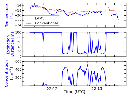 Abstract:A new laser air-motion sensor measures the true airspeed with a standard uncertainty of less than 0.1 m s−1 and so reduces uncertainty in the measured component of the relative wind along the longitudinal axis of the aircraft to about the same level. The calculated pressure expected from that airspeed at the inlet of a pitot tube then provides a basis for calibrating the measurements of dynamic and static pressure, reducing standard uncertainty in those measurements to less than 0.3 hPa and the precision applicable to steady flight conditions to about 0.1 hPa. [...]
Citation: Cooper, W. A., Spuler, S. M., Spowart, M., Lenschow, D. H., and Friesen, R. B.: Calibrating airborne measurements of airspeed, pressure and temperature using a Doppler laser air-motion sensor, Atmos. Meas. Tech., 7, 3215-3231, doi:10.5194/amt-7-3215-2014, 2014.
For more information see the LAMS web page
Carbone and Li, 2015:
Journal of the Atmospheric Sciences, 72, 2703-2718.

Abstract: Based upon on the findings of Y. Li and R. E. Carbone, the association of tropical rainfall with SST structure is further explored, with emphasis on the MJO passband. Analyses include the tropical Indian Ocean, Maritime Continent, and tropical western Pacific regions. The authors examine the anomalies of and correlations between SST structure, the frequency of rainfall events, and rainfall amount. Based on detailed examination of a 49-month time series, all findings are statistical inferences and interpretations consistent with established theory. [...]
Citation: Carbone, R.E., and Y. Li, 2015: Tropical oceanic rainfall and sea surface temperature structure: Parsing causation from correlation in the MJO. J. Atmos. Sci., 72, 2703-2718, DOI: 10.1175/JAS-D-14-0226.1.
Horst, Semmer and Maclean, 2015:
Boundary-Layer Meteorology,155, 371-395.
 Abstract: We propose that flow distortion within a non-orthogonal CSAT3 sonic anemometer is primarily due to transducer shadowing, which is caused by wakes in the lee of the acoustic transducers impinging on their measurement paths. The dependence of transducer shadowing on sonic path geometry, wind direction and atmospheric stability is investigated with simulations that use surface-layer data from the Horizontal Array Turbulence Study (HATS) field program and canopy roughness-sublayer data from the CHATS (Canopy HATS) field program. We demonstrate the efficacy of correcting the CSAT3 for transducer shadowing with measurements of its flow distortion in the NCAR wind tunnel, combined with 6 months of data collected in the atmospheric surface layer with adjacent CSAT3 and orthogonal ATI-K sonic anemometers at the NCAR Marshall field site. [...]
Citation: Horst, T.W., S.R. Semmer, & G. Maclean, 2015: Bound-Layer Meteorol, 155, 371. doi:10.1007/s10546-015-0010-3
Hayman, et. al., 2014:
Polarization lidar observations of backscatter phase matrices from oriented ice crystals and rain
Optics Express, 22, 16976-16990.
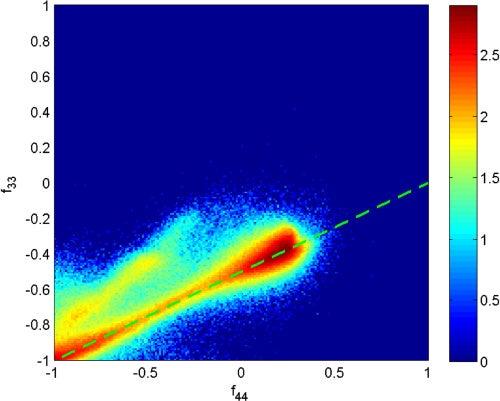 Abstract: Oriented particles can exhibit different polarization properties than randomly oriented particles. These properties cannot be resolved by conventional polarization lidar systems and are capable of corrupting the interpretation of depolarization ratio measurements. Additionally, the typical characteristics of backscatter phase matrices from atmospheric oriented particles are not well established. The National Center for Atmospheric Research High Spectral Resolution Lidar was outfitted in spring of 2012 to measure the backscatter phase matrix, allowing it to fully characterize the polarization properties of oriented particles. [...]
Citation: Hayman, M., S. M. Spuler, and B. M. Morley, 2014: Polarization lidar observations of backscatter phase matrices from oriented ice crystals and rain. Optics Express, 22, 16976-16990, doi:10.1364/OE.22.016976.
For more information see the HSRL web page
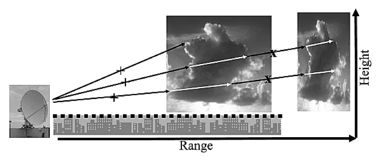
Lee et. al., 2014:
Distance Velocity-Azimuth Display (DVAD)—New interpretation and analysis of Doppler velocity
Monthly Weather Review, 142, 573-589
 Abstract: The concept and mathematical framework of the distance velocity–azimuth display (DVAD) methodology is presented. DVAD uses rVd (Doppler velocity scaled by the distance from the radar to a gate, r) as the basis to display, interpret, and extract information from single Doppler radar observations. Both linear and nonlinear wind fields can be represented by the same Cartesian polynomial with different orders. DVAD is mathematically concise and superior to the velocity–azimuth display (VAD) in interpreting and deducing flow characteristics. [...]
Citation: Lee, W.-C., X. Tang, and B.J. Jou, 2014: Distance Velocity-Azimuth Display (DVAD)—New interpretation and analysis of Doppler velocity. Mon. Weather Rev., 142, 573-589, DOI: 10.1175/MWR-D-13-00196.1.
Cohn, Hock, et. al., 2013:
Driftsondes: Providing in situ long-duration dropsonde observations over remote regions
Bulletin of the American Meteorological Society, 94, 1661-1674.
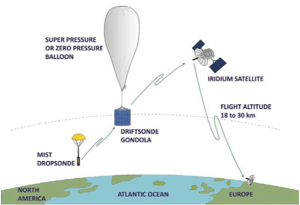 Abstract: Constellations of driftsonde systems— gondolas floating in the stratosphere and able to release dropsondes upon command— have so far been used in three major field experiments from 2006 through 2010. With them, high-quality, high-resolution, in situ atmospheric profiles were made over extended periods in regions that are otherwise very difficult to observe. The measurements have unique value for verifying and evaluating numerical weather prediction models and global data assimilation systems; they can be a valuable resource to validate data from remote sensing instruments, especially on satellites, but also airborne or ground-based remote sensors. [...]
Citation: Cohn, S.A., T.F. Hock, P. Cocquerez (more) , 2013: Driftsondes: Providing in situ long-duration dropsonde observations over remote regions. Bull. Amer. Met. Soc., 94, 1661-1674, DOI: 10.1175/BAMS-D-12-00075.1.
For more information see the Driftsonde web page
Li and Carbone, 2012:
Excitation of Rainfall Over the Tropical Western Pacific
Journal of Atmospheric Science, 69, 2983-2994
 Abstract: The authors have examined 4 years of satellite-derived SST and rainfall data in anticipation of a relationship between SST structure and the excitation of convective rainfall. The results exhibit a strong excitation signal consistent with the presence of mesoscale SST gradients in about 75% of approximately 10 000 rainfall onset events. Rainfall onset events occur at locations with enhanced horizontal convergence, as inferred by the Laplacian of SST on scales of order 100 km. The daily SST field exhibits multiscale patchiness, spanning a 2+°C range. The signal is disproportionately large at SSTs that are 0.25°C above the mean, [...]
Citation: Yanping Li and R. E. Carbone, 2012: Excitation of Rainfall over the Tropical Western Pacific. J. Atmos. Sci., 69, 2983-2994, doi: 10.1175/JAS-D-11-0245.1
(This paper received the UCAR Outstanding Publication Award for 2016)
Ellis and Vivekanandan, 2010:
Water vapor estimates using simultaneous dual-wavelength radar observations
Radio Science, 45, DOI: 10.1029/2009RS004280.
 Abstract: A technique for the estimation of humidity in the lower troposphere using simultaneous dual-wavelength radar observations is proposed and tested. The method compares the reflectivity from clouds and precipitation of a non-attenuated wavelength (S-band, 10 cm) and an attenuated wavelength (Ka-band, 8 mm) to compute the clear-air gaseous attenuation at the attenuated wavelength. These estimates are of total gaseous attenuation on radar ray segments that extend from the radar to a cloud/precipitation echo or from one echo to another. [...]
Citation: Ellis, S.M., and J. Vivekanandan, 2010: Water vapor estimates using simultaneous dual-wavelength radar observations. Radio Science, 45, RS5002, DOI: 10.1029/2009RS004280.
Hubbert et.al., 2010:
Journal of Atmospheric and Oceanic Technology, 27, 1583–1598
 Abstract: In this two-part paper the biases of polarimetric variables from simultaneous horizontally and vertically transmitted (SHV) data are investigated. Here, in Part I, a radar-scattering model is developed and antenna polarization errors are investigated and estimated. In Part II, experimental data from the National Center for Atmospheric Research S-band dual-polarization Doppler radar (S-Pol) and the National Severe Storms Laboratory polarimetric Weather Surveillance Radar-1988 Doppler (WSR-88D) radar, KOUN, are used to illustrate biases in differential reflectivity (Zdr). [...]
Citation: Hubbert, J.C., S.M. Ellis, M.J. Dixon, and G. Meymaris, 2010: Modeling, error analysis and evaluation of dual polarization variables obtained from simultaneous horizontal and vertical polarization transmit radar. Part I: Modeling and antenna errors. J. Atmos. Ocean. Tech., 27, 1583–1598, DOI: 10.1175/2010JTECHA1336.1.
(A two part paper nominated by EOL to the UCAR Outstanding Publication Award in 2014)
Aquino et. al., 2017:
Data Science Journal, 16, 7, 1-7
![]() Abstract: In an effort to lead our community in following modern data citation practices by formally citing data used in published research and implementing standards to facilitate reproducible research results and data, while also producing meaningful metrics that help assess the impact of our services, the National Center for Atmospheric Research (NCAR) Earth Observing Laboratory (EOL) has implemented the use of Digital Object Identifiers (DOIs) (DataCite 2017) for both physical objects (e.g., research platforms and instruments) and datasets. [...]
Abstract: In an effort to lead our community in following modern data citation practices by formally citing data used in published research and implementing standards to facilitate reproducible research results and data, while also producing meaningful metrics that help assess the impact of our services, the National Center for Atmospheric Research (NCAR) Earth Observing Laboratory (EOL) has implemented the use of Digital Object Identifiers (DOIs) (DataCite 2017) for both physical objects (e.g., research platforms and instruments) and datasets. [...]
Citation: Aquino, J. et al., 2017: Motivation and Strategies for Implementing Digital Object Identifiers (DOIs) at NCAR’s Earth Observing Laboratory – Past Progress and Future Collaborations. Data Science Journal. 16, p.7. DOI: 10.5334/dsj-2017-007

