WISPIT
Winter Icing Storms Project Instrumentation Test
The Winter Icing and Storms Project (WISP) was a cooperative research effort designed to study the structure and evolution of winter storms. Its primary objective was to improve the understanding of the processes involved in the production and depletion of supercooled liquid water content in winter storms, and to develop improved aircraft icing forecasts on the local, regional, and national scales. WISPIT (WISP Instrumentation Test) was the third in a series of deployments (over 4 years with 2 years of analysis) sponsored principally by the Federal Aviation Administration (FAA), NCAR's Research Applications Program (RAP), National Oceanic and Atmospheric Administration (NOAA), and a variety of university support [Colorado State University (CSU) and the Pennsylvania State University (PSU)].
Running concurrently with WISPIT, was a ground de-icing and snow gauge project conducted by NCAR/RAP in collaboration with United Airlines. Special surface mesonet and snow gauge instrumentation were deployed at Stapleton International Airport.
Scientific Objectives
The primary objectives of WISP were to: (1) Improve the understanding of the processes involved in the production and depletion of supercooled liquid water content in winter storms; and (2) Improve forecasts of aircraft icing in winter storms. WISP Investigators examined contributions from local topographic forcing, upslope flow (both cyclonic and anticyclonic), conditional symmetric instability, cold air damming/barrier jets, synoptic and mesoscale fronts, jet streaks, diabatic processes, advection of supercooled liquid water content, and convective instability.
WISPIT was conducted to obtain additional focused tests of instrumentation during shorter period and was a much reduced effort from the previous WISP campaigns (WISP-90 and WISP-91). The purpose was to test and strengthen observing capabilities in new areas needed for a planned major field activity in the winter of 1993/1994 (WISP-94). The observing systems and techniques studied in WISPIT were critical components of subsequent field campaigns. Specific instrumentation tests included: (1) Measurements of ice nuclei (CCN), and other characteristics of the aerosol populations; (2) Remote characterization of ice crystal characteristics by multiple-polarization radar; (3) Measurement of small ice crystals; and (4) Diagnosis of cloud layers and icing hazard altitude by means of remote measurements.
Observations
Aircraft - The NCAR King Air flew 11 research missions from 15 February to 15 March and was equipped for cloud physics studies and certified for flight into known icing conditions.
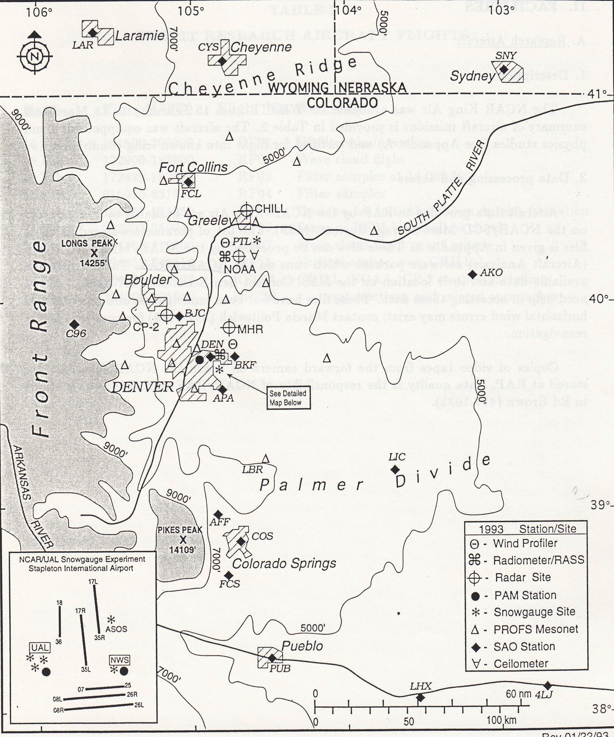
Radars – The Mile High Radar (MHR) collected data almost continuously during WISPIT operational periods, while the NCAR CP-2, the CSU CHILL, and the NOAA K-band radars collected data during selected operational periods.
Surface – A network of twenty-two (22) NOAA Prototype Regional Operational Forecast System (PROFS) fixed stations was deployed and operated continuously. These stations collected 5-min average measurements of wind, temperature, dewpoint, pressure, precipitation, and solar radiation. No NCAR Portable Mesonet (PAM) stations were deployed specifically for WISPIT, however, three (3) PAM stations were operating at Stapleton Airport as part of a ground de-icing project conducted by NCAR/RAP. These stations operated continuously during WISPIT and recorded 1-min averages of temperature, dew point, pressure, winds, as well as other measurements specific to the de-icing project.
Microwave Radiometers – The NOAA/Wave Propagation Laboratory (WPL) operated two (2) dual-channel microwave radiometers continuously during WISPIT, located at the Stapleton Airport and Platteville sites. These radiometers measured the brightness temperatures at two frequencies (20.6 and 31.65 GHz), providing calculations of column total integrated liquid water and water vapor. An infrared radiometer (10.5 um wavelength) was also operated at Stapleton site recording cloud base temperatures every 2-min. Surface measurements of temperature, dew point, and pressure were also recorded at the Stapleton and Platteville sites.
Profilers – NOAA operated three wind profilers of different wavelengths (915, 404, and 50 MHz) at Platteville, and one at Stapleton Airport (915 MHz). These wind profiling radars operated in all weather conditions and made use of backscatter from small-scale (one half the radar wavelength) refractive index fluctuations in the atmosphere to determine wind speed and direction. In addition, Radio Acoustic Sounding Systems (RASS) providing temperature profiles were operated at both sites.
Upper Air – One mobile NCAR Cross-Chain Loran Atmospheric Sounding Systems (CLASS) site was operated during WISPIT providing thermodynamic and wind profiles. Soundings were normally taken every 3-hour intervals during IOPs. Seventeen 17 soundings were taken from the mobile CLASS system from 8 different locations. Additional soundings on 8 days were taken by NOAA using Omega and Loran tracking systems. Upper air soundings in the WISPIT region were obtained by the National Weather Service (NWS) at 00 and 12 UTC daily.
Network Map
 |
Data
| Aircraft | NCAR King Air |
| Lidar | 1 NOAA Lidar ceilometer |
| Model | Real-time NCAR/PSU MM5 mesoscale model; NOAA MAPS, AVN, and NGM model |
| Profilers | 3 NOAA/WPL wind profilers including RASS |
| Radar | MHR; CSU CHILL; NCAR CP-2; NOAA/WPL K-band |
| Radiometers | 2 NOAA/WPL dual-channel microwave radiometers; 1 WPL infrared radiometer |
| Surface | NOAA/PROFS Mesonet (22 stations); 3 PAM stations; Routine NWS regional surface observations (SAO) |
| Upper Air | 1 NCAR CLASS mobile system |
| Upper Air | Routine NWS soundings (00 and 12 UTC) from 8 regional stations |
Further information and details on WISPIT can be found at:
Winter Icing and Storms Project Instrumentation Test (WISPIT) Data Catalog, 15 February – 15 March 1993. National Center for Atmospheric Research, Research Applications Program. 15 August 1993. 56 pp
Winter Icing and Storms Project Instrumentation Test (WISPIT) Operations Plan. National Center for Atmospheric Research, Research Applications Program. 1 February 1993. 61 pp.
Principal Investigators:
- Roy Rasmussen NCAR/RAL
- Marcia Politovich NCAR/RAL
Data Manager:
- EOL Archive NCAR/EOL/DMS