WISP-94
Winter Icing and Storms Project 1994
The Winter Icing and Storms Project (WISP) was a cooperative research effort designed to study the structure and evolution of winter storms. Its primary objective was to improve the understanding of the processes involved in the production and depletion of supercooled liquid water content in winter storms, and to develop improved aircraft icing forecasts on the local, regional, and national scales. WISP-94 was the fourth in a series of deployments (over 4 years with 2 years of analysis) sponsored principally by the Federal Aviation Administration (FAA), NCAR's Research Applications Program (RAP), National Oceanic and Atmospheric Administration (NOAA), and a variety of university support [Colorado State University (CSU), The University of Wyoming (UW), and the Pennsylvania State University (PSU)].
A second experiment was run concurrently with WISP-94, as part of NCAR/RAP’s ongoing work to develop a ground de-icing display for aviation purposes. The experiment made use of real-time snowgauge, automated weather station, and radar data to test a real-time display of liquid equivalent snowfall rate and future reflectivity using the Radar Echo Prediction (REP) system, and to perform man-made nowcasts of snowfall from 7:00 AM to 10:00 PM (local time) during snow events.
Scientific Objectives
The primary objectives of WISP were to: (1) Improve the understanding of the processes involved in the production and depletion of supercooled liquid water content in winter storms; and (2) Improve forecasts of aircraft icing in winter storms. WISP Investigators examined contributions from local topographic forcing, upslope flow (both cyclonic and anticyclonic), conditional symmetric instability, cold air damming/barrier jets, synoptic and mesoscale fronts, jet streaks, diabatic processes, advection of supercooled liquid water content, and convective instability.
The central objective of the WISP-94 was to understand the factors determining ice crystal concentrations in wintertime storms of the Colorado Front Range. Specific goals included: (1) Documenting concentrations of ice crystals that form in these wintertime storms, as a function of location, altitude, and temperature, and to measure the associated variability in concentrations for invariant values of controlling factors such as cloud type, temperature, or air parcel trajectory; (2) Investigating the extent to which ice concentrations are predictable from, or even correlated with, a set of ice nucleus measurements, and to learn if the natural ice crystal concentrations can be duplicated by processing air samples in a large cloud chamber; (3) Investigating the possible roles of supersaturation, evaporation, electrification, large drops, and pollution in ice formation; (4) Studying ice formation in wave clouds and use those observations to infer production mechanisms in those and other cloud types found in the Front Range area; and (5) Searching for correlations between ice crystal concentrations and other factors that may indicate causative relationships, such as large-droplet concentrations, occurrence of riming, air-mass trajectories, aerosol particle concentrations, etc.
Observations
Thirty-eight (38) Intensive Operations Periods (IOPs) were conducted during WISP-94. Details on WISP-94 facilities are summarized below:
Aircraft - The UW King Air and the NCAR Electra flew from 25 January to 25 March and 1 February to 25 March, respectively. Both research aircraft were equipped for cloud physics studies and certified for flight into known icing conditions. Each aircraft obtained bag samples of air during flights and delivered them to the CSU Cloud Simulation and Aerosol Laboratory for analysis. The King Air flew 33 missions and the Electra flew 29 missions.
Radars – The National Weather Service (NWS) NEXRAD (WSR-88D), the NCAR CP-4, the CSU CHILL, and the NOAA Ka-band radars collected data almost continuously during the WISP-94 IOPs. The NOAA Environmental Technology Laboratory (ETL) operated a Ka-band (8.66 mm) multi-parameter radar system at the Erie site, using a unique multiple-phase plate rotated to collect non-standard polarization data in multiple states, as well as fixed states.
Surface – A network of twenty-two (22) NOAA Prototype Regional Operational Forecast System (PROFS) fixed stations was deployed and operated continuously. These stations collected 5-min average measurements of wind, temperature, dewpoint, pressure, precipitation, and solar radiation. In addition, all NCAR sounding sites were equipped with automated surface stations recording 1-min average measurements of wind, pressure, temperature and relative humidity. Also, the State of Wyoming maintained a network of nineteen (19) automated weather stations to monitor highway conditions. Data were recorded every 10-min of temperature, dew point, precipitation, relative humidity, and wind.
Weather Observer Networks – A network of approximately 100 volunteer weather observers was established for WISP-94 to measure snowfall, water equivalent, crystal habit, degree of riming, aggregation, and crystal size. Many observers recorded information as often as every hour, but time resolution and quality varied by observer. Additional daily observations were provided by the Mountain States Weather Service volunteer network.
CSU Cloud Simulation and Aerosol Laboratory – Bag samples were collected at the CSU Cloud Simulation and Aerosol Laboratory in Fort Collins. Instrumentation included a condensation nucleus (CN) counter, a cloud condensation nucleus (CCN) counter, a continuous flow diffusion chamber (CFD) for ice nucleus (IN) measurement, and a dynamic expansion cloud chamber (DCC) for cloud simulation and IN measurements.
Snow Crystal Morphology Van (“Microvan”) – A microvan was used to collect and analyze snow crystal habits and collect bulk samples of snow crystals for chemical content analysis. Collected data included snow crystal morphology, bulk snow samples for snow chemistry and isotope analysis, ice nuclei filters, and bag samples to determine CCN concentrations. The van primarily operated between the Ka-band and the CHILL radars or north of CHILL.
Microwave Radiometers – The NOAA/ETL operated three (3) dual-channel microwave radiometers located at Stapleton Airport, Platteville, and Erie (co-located with wind profilers and the Ka-band radar). All three measured the brightness temperatures at two frequencies (20.6 and 31.6 GHz), providing calculations of column total integrated liquid water and water vapor. Similar data were collected by an ETL three-channel (20.6, 31.6, and 90 GHz) steerable microwave radiometer, located at Erie and operated during Ka-band operations. Infrared radiometers (10 to 11.5 um wavelength) were also operated at the three sites, recording cloud base temperatures every 2-min. Cloud base height were recorded at the Platteville and Stapleton sites using lidar ceilometers. With the exception of the steerable radiometer, these instruments operated continuously during WISP-94.
Profilers – One NOAA/ETL Wind Profiler was operated at Platteville and one at Stapleton Airport, providing hourly wind profiles. In addition, one wind profiler was used exclusively for Radio Acoustic Sounding System (RASS) measurements, which collected temperature profiles at the Erie-1 site.
Upper Air – Seven (7) NCAR Cross-Chain Loran Atmospheric Sounding Systems (CLASS) sites (five fixed and two mobile) were operated during WISP-94 providing thermodynamic and wind profiles. Soundings were normally taken every 3-hour intervals during IOPs. Approximately 125 soundings were taken from the mobile CLASS system from 22 different locations. Upper air soundings in the WISP-94 region were obtained by the NWS at 00 and 12 UTC daily.
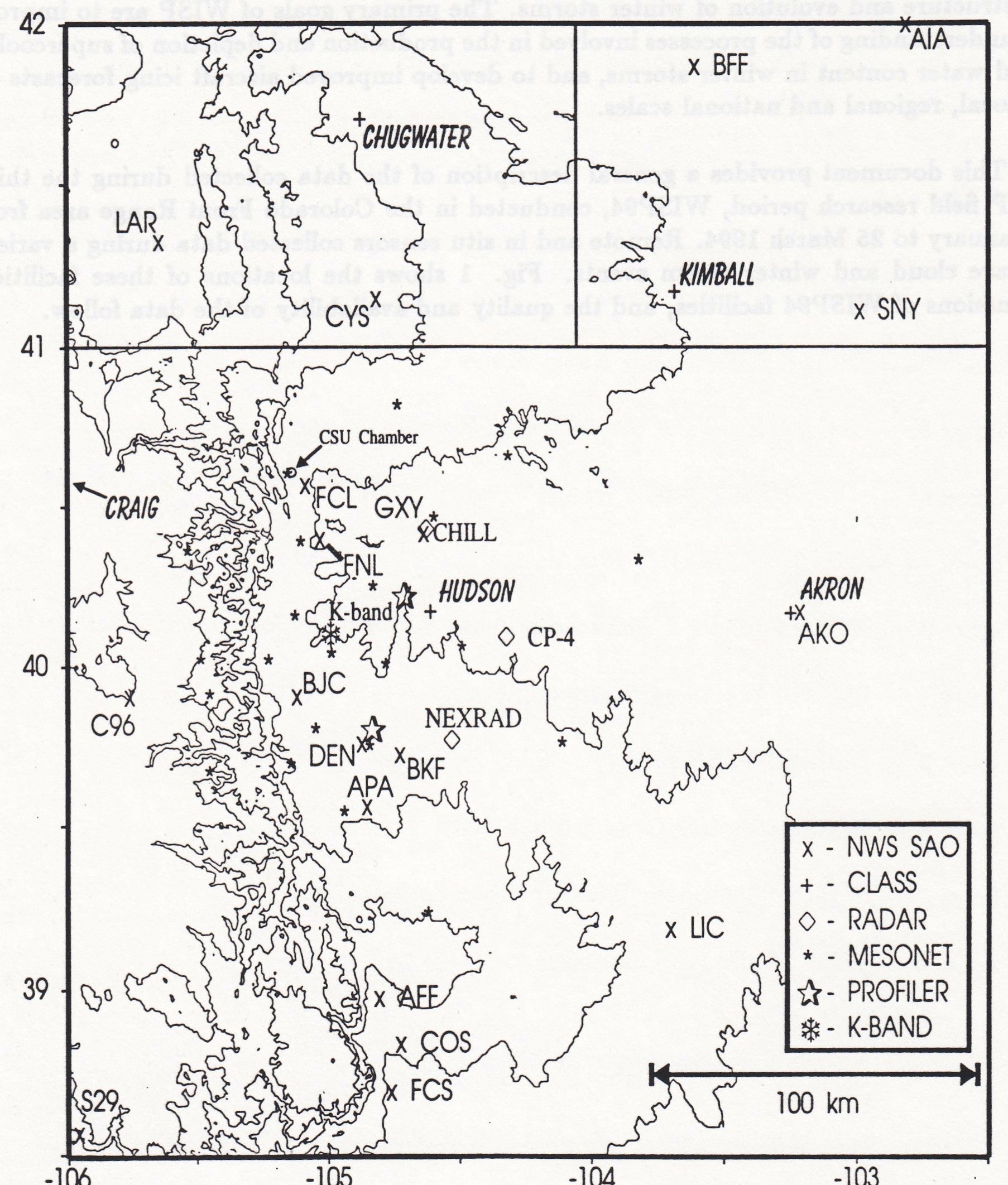
Network Map
 |
Data
| Aircraft | UW King Air; NCAR Electra |
|---|---|
| Lidar | NWS Lidar ceilometers (2) |
| Model | Real-time NCAR/PSU MM5 mesoscale model; NOAA MAPS and NGM model |
| Profilers | 3 NOAA/ETL wind profilers including RASS |
| Radar | NWS NEXRAD; CSU CHILL; NCAR CP-4; NOAA/ETL Ka-band |
| Radiometers | 3 NOAA/ETL dual-channel microwave radiometers; 1 ETL three-channel steerable microwave radiometer; 2 ETL infrared radiometers |
| Surface | NOAA/PROFS Mesonet (22 stations); NCAR CLASS (6 stations); State of Wyoming Highway network (19 stations); Routine NWS regional surface observations (SAO) |
| Surface | Volunteer snowfall observer networks; Snow Crystal Morphology Van (“Microvan”); CSU Cloud Simulation and Aerosol Laboratory |
| Upper Air | 7 NCAR CLASS systems (5 fixed and 2 mobile) |
| Upper Air | Routine NWS soundings from 4 regional stations |
Further information and details on WISP-94 can be found at:
1994 Winter Icing and Storms Project (WISP94) Data Catalog, 25 January – 25 March 1994. National Center for Atmospheric Research, Research Applications Program. 3 June 1994. 97 pp.
Rasmussen, R.M., and W.A. Cooper (Editors), 1993: Winter Icing and Storms Project 1994 (WISP94) Scientific Overview. National Center for Atmospheric Research, February 1993, 46 pp.
Stossmeister, G. (Editor), 1994: Winter Icing and Storms Project 1994 (WISP94) Operations Plan. National Center for Atmospheric Research, February 1994, 174 pp.
Principal Investigators:
- Roy Rasmussen NCAR/RAL
- Marcia Politovich NCAR/RAL
Data Manager:
- EOL Archive NCAR/EOL/DMS