WISP-91
1991 Winter Icing and Storms Program
The Winter Icing and Storms Project (WISP) was a cooperative research effort designed to study the structure and evolution of winter storms. Its primary objective was to improve the understanding of the processes involved in the production and depletion of supercooled liquid water content in winter storms, and to develop improved, operational aircraft icing forecast techniques on the local, regional, and national scales. WISP-91 was the second in a series of deployments (over 4 years with 2 years of analysis) sponsored principally by the Federal Aviation Administration (FAA), NCAR's Research Applications Program (RAP), National Oceanic and Atmospheric Administration (NOAA), Environment Canada, and a variety of university support [Colorado State University (CSU), The University of Wyoming (UW), Pennsylvania State University (PSU), and the University of North Dakota (UND)].
An important collaboration with WISP-91 was with the Department of Energy (DOE)’s Atmospheric Radiation Measurement (ARM) test program. The primary period of this test program ran from 15 February to 15 March 1991.
Scientific Objectives
The primary objectives of WISP were to: (1) Improve the understanding of the processes involved in the production and depletion of supercooled liquid water content in winter storms; and (2) Improve forecasts of aircraft icing in winter storms. WISP Investigators examined contributions from local topographic forcing, upslope flow (both cyclonic and anticyclonic), conditional symmetric instability, cold air damming/barrier jets, synoptic and mesoscale fronts, jet streaks, diabatic processes, advection of supercooled liquid water content, and convective instability.
The specific WISP-91 scientific objectives were to: (1) Document the characteristics of winter storms in the Denver area; (2) Study the effects of local terrain variations on liquid water production and depletion; (3) Examine microphysical properties of the clouds, with emphasis on large supercooled droplet formation ice crystal growth; and (4) Examine the structure of cold fronts in the Denver area.
Observations
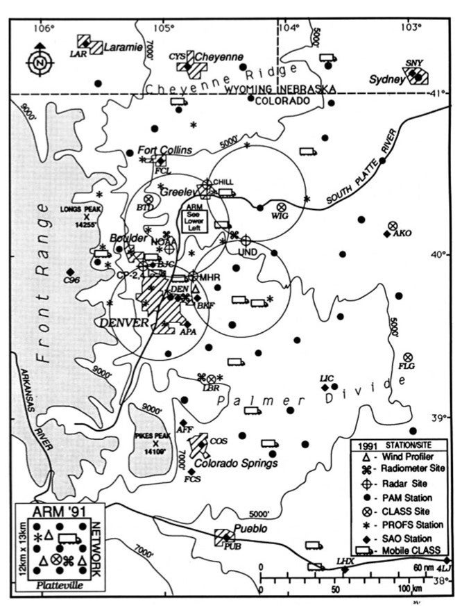
Fifteen (15) Intensive Operations Periods (IOPs) were conducted during WISP-91. IOPs were sorted into 3 categories: (1) shallow anticyclonic storms; (2) shallow cyclonic storms; and (3) deep cyclonic storms. The following special facilities/observations were deployed during WISP-91.
Aircraft - The UW King Air and the UND Citation flew from 15 January to 31 March and 8 February to 14 March, respectively. Both research aircraft were equipped for cloud physics studies in known icing conditions. The King Air flew 18 missions and the Citation flew 11 missions.
Radars – The National Weather Service (NWS) Mile High Radar (MHR), the UND radar, and the CSU CHILL radar collected data almost continuously during the WISP-91 IOPs, while the NCAR CP-2 and CP-4 radars and two (2) NOAA radars collected data during selected IOPs. The NOAA Wave Propagation Laboratory (WPL) operated a dual-wavelength radar system at the Erie-1 site between 14 February and 30 March. The system consisted of the NOAA C/X band (3.2 cm) and NOAA/K K-band (0.87 cm) radars with antennas electronically slaved to point in the same direction.
Surface – A network of twenty-two (22) NOAA Prototype Regional Operational Forecast System (PROFS) fixed stations was deployed and operated continuously. These stations collected 5-min average measurements of wind, temperature, dewpoint, pressure, precipitation, and solar radiation. In addition, a special network of forty-nine (49) NCAR Portable Automated Mesonet (PAM) stations were deployed and operated continuously. Thirty nine (39) of these PAM stations were dedicated to WISP-91 and Ten (10) stations were dedicated to the DOE-ARM Test Program. All these PAM stations collected 1-min average measurements of wind, precipitation, temperature and dewpoint. Six (6) of these stations were equipped with heated snow gauges.
Observer Snowfall Networks – Three volunteer snowfall observer networks to measure snowfall, water equivalent, crystal type, and degree of riming were established for WISP-91. They included: (1) 40 observers in the Boulder/Denver area; (2) 35 observers in the Fort Collins/Northern Colorado area; and (3) 19 high schools across the Eastern Plains in the WISP-91 domain. Time resolution varied by observer and storm.
Microwave Radiometers – The NOAA/WPL operated three (3) dual-channel microwave radiometers located at Stapleton Airport, Platteville, and Elbert. All three measured the brightness temperatures at two frequencies (20.6 and 31.65 GHz), providing calculations of column total integrated liquid water and water vapor. Similar data were collected by a WPL three-channel (20.6, 31.65, and 90 GHz) steerable microwave radiometer, located at Roggen from 13 January to 13 February and at Erie from 16 February to 2 April. WPL Infrared radiometers (10.5 um wavelength) were also operated at the Stapleton and Elbert sites, recording cloud base temperatures every 2-min.
Profilers – Three (3) WPL Wind Profilers were operated at Platteville and one at Stapleton Airport, providing hourly wind profiles. In addition, one wind profiler was used exclusively for Radio Acoustic Sounding System (RASS) measurements, which collected temperature profiles at the Erie-1 site. In addition, six (6) boundary layer wind profilers were operated in the Denver area for the ASCOT project.
Lidar - The NWS operated a lidar ceilometer at Stapleton Airport. 30-sec averages of cloud base height of the lowest cloud deck directly above the instrument were recorded.
Upper Air – Seven (7) NCAR Cross-Chain Loran Atmospheric Sounding Systems (CLASS) sites (six fixed and one mobile) were operated during WISP-91 providing thermodynamic and wind profiles. Soundings were normally taken every 3-hour intervals during IOPs. Approximately 55 soundings were taken from the mobile CLASS system from 17 different locations.
Network Map
 |
Data
| Aircraft | UW King Air; UND Citation |
| Lidar | NWS Lidar ceilometer |
| Model | Real-time NCAR/PSU MM4 mesoscale model; NOAA MAPS model |
| Profilers | 3 NOAA/WPL wind profilers including RASS |
| Radar | NWS MHR; UND; CSU CHILL; NCAR CP-2 and CP-4; WPL radar system |
| Radiometers | 3 WPL dual-channel microwave radiometers; 1 WPL three-channel steerable microwave radiometer; 2 WPL infrared radiometers |
| Surface | NOAA/PROFS Mesonet (22 stations); NCAR PAM (49 stations including 10 deployed for DOE/ARM project); Routine NWS regional surface observations |
| Surface | 3 volunteer snowfall observer networks |
| Upper Air | 7 NCAR CLASS systems (6 fixed and 1 mobile) |
| Upper Air | Routine NWS soundings from 8 regional stations |
Further information and details on WISP-91 can be found at:
Principal Investigators:
- Roy Rasmussen NCAR/RAL
- Marcia Politovich NCAR/RAL
Data Manager:
- EOL Archive NCAR/EOL/DMS