WISP-90
1990 Winter Icing and Storms Project
The Winter Icing and Storms Project (WISP) was a cooperative research effort designed to study the structure and evolution of winter storms. Its primary objective was to investigate the production and depletion of supercooled liquid water in winter storms and thereby enhance aircraft safety through improved forecasts of icing conditions. WISP-90 was the first in a series of deployments (over 4 years with 2 years of analysis) sponsored principally by the Federal Aviation Administration (FAA), NCAR's Research Applications Program (RAP), National Oceanic and Atmospheric Administration (NOAA), and a variety of university support [The University of Wyoming (UW), University of North Dakota (UND) and Denver Metropolitan State].
Scientific Objectives
The primary objectives of WISP were to: (1) Improve the understanding of the processes involved in the production and depletion of supercooled liquid water content in winter storms; and (2) Improve forecasts of aircraft icing in winter storms. WISP Investigators examined contributions from local topographic forcing, upslope flow (both cyclonic and anticyclonic), conditional symmetric instability, cold air damming/barrier jets, synoptic and mesoscale fronts, jet streaks, diabatic processes, advection of supercooled liquid water content, and convective instability.
The specific WISP-90 scientific objectives were to: (1) Document the characteristics of winter storms in the Denver area; (2) Study the effects of local terrain variations on liquid water production and depletion; (3) Examine microphysical properties of the clouds, with emphasis on large supercooled droplet formation ice crystal growth; and (4) Examine the structure of cold fronts in the Denver area.
Observations
Ten (10) Intensive Operations Periods (IOPs) were conducted over the two-month deployment. The following special facilities were deployed during WISP-90.
Aircraft - The UW King Air and the UND Citation flew from 1-28 February and 12-30 March, respectively. Both research aircraft were equipped for cloud physics studies in known icing conditions. The King Air flew 11 missions and the Citation flew 10 missions.
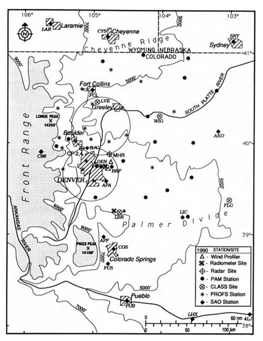
Radars – The National Weather Service (NWS) Mile High Radar (MHR) and the NCAR CP-3 radar collected data almost continuously during the WISP-90 IOPs. The MHR was a 10-cm wavelength Doppler and CP-3 was a 5.45-cm wavelength Doppler.
Surface – A network of twenty-two (22) NOAA Prototype Regional Operational Forecast System (PROFS) fixed stations was deployed and operated continuously. These stations collected 5-min average measurements of wind, temperature, dewpoint, pressure, precipitation, and solar radiation. In addition, a special network of nineteen (19) NCAR Portable Automated Mesonet (PAM) stations were deployed and operated continuously. These stations collected measurements of wind, precipitation, temperature and dewpoint. Five (5) of these stations were equipped with heated snow gauges.
Microwave Radiometers – The NOAA Wave Propagation Laboratory (WPL) operated three (3) dual-channel microwave radiometers located at Stapleton Airport, Platteville, and Elbert. All three measured the brightness temperatures at two frequencies (20.6 and 31.65 GHz), providing calculations of column total integrated liquid water and water vapor. An additional dual-channel radiometer (23.8 and 31.4 GHz) was operated by Erbtec Inc. located in Boulder. These instruments operated continuously during WISP-90.
Profilers – Three WPL Wind Profilers were operated at Stapleton Airport, Erie, and Platteville, providing hourly wind profiles. In addition, these WPL wind profiler were equipped with a Radio Acoustic Sounding System (RASS) which collected temperature profiles. The wind profiler in Erie was used exclusively for RASS measurements.
Upper Air – Four (4) NCAR Cross-Chain Loran Atmospheric Sounding Systems (CLASS) sites were operated during WISP-90 providing thermodynamic and wind profiles. The Sites were located at Elbert, Flagler, Wiggins, and Fort Collins. Soundings were taken every 3- or 6-hour intervals during IOPs. Approximately 300 soundings were taken from the 4 CLASS sites.
Network Map
 |
Data
| Aircraft | UW King Air; UND Citation |
|---|---|
| Model | NOAA/FSL forecasting and nowcasting fields of wind, supercooled liquid water content, and snowfall outlooks |
| Profilers | 3 NOAA/WPL wind profilers including RASS |
| Radar | NWS Mile High Radar (MHR); NCAR CP-3 |
| Radiometers | 3 NOAA/WPL dual-channel Radiometers; 1 Erbtec Inc. dual-channel radiometer |
| Surface | NOAA/PROFS Mesonet (22 stations); NCAR PAM (19 stations) |
| Surface | 2 volunteer snowfall observer networks (100 observers in Boulder/Denver area and 150 observers in the Ft. Collins area) |
| Upper Air | 4 NCAR CLASS sites |
 |
Further information and details on WISP-90 can be found at:
1990 Winter Icing and Storms Project (WISP-90) Data Catalog, 1 February – March 1990. National Center for Atmospheric Research, Research Applications Program. 30 May 1990. 63 pp.
Rasmussen, R.M., and M.K. Politovich, 1990: Winter Icing and Storms Project (WISP) Scientific Overview. National Center for Atmospheric Research. 50 pp.
Principal Investigators:
- Roy Rasmussen NCAR/RAL
- Marcia Politovich NCAR/RAL
Data Manager:
- EOL Archive NCAR/EOL/DMS