W-MONEX
Winter Monsoon Experiment
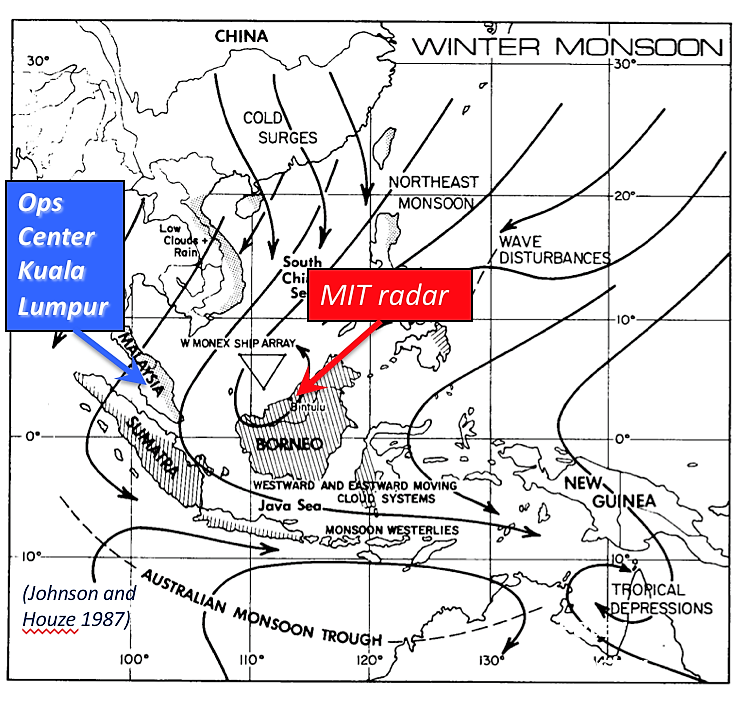
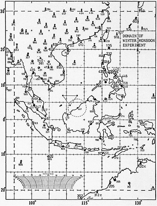
The Monsoon Experiment (MONEX) was the core of the Global Atmospheric Research Program (GARP) Monsoon subprogram, which was a major international effort to achieve a better understanding of the planetary monsoon circulation, the major seasonal perturbation of the general circulation of the atmosphere and the influence of the annual cycle of precipitation associated with the monsoon on the agriculture of the many populous nations of the region. The Winter Monsoon Experiment (W-MONEX), a subprogram of the First GARP Global Experiment (FGGE) was the first truly international atmospheric-oceanic experiment in the Eastern Hemisphere. Major International countries participating were the U.S., U.S.S.R., Japan, Australia, and China. The W-MONEX goal was to study both the global and regional aspects of the winter monsoon circulation over East Asia, the maritime continent, and Australia. A wide array of observing systems – research aircraft, ships, soundings, research radar, and surface stations – was deployed to investigate the circulation features of the winter monsoon (see Network Map). The W-MONEX Operations Center was located in Kuala Lumpur and hosted by the Malaysian Meteorological Service. W-MONEX took place during December 1978 through March 1979 in the South China Sea, with an enhanced observing period during the month of December 1978. Fourteen (14) focused experiments were conducted during this enhanced period.
The two W-MONEX Aircrafts (NCAR Electra and NOAA P-3) flew a total of 27 missions in the enhanced period, representing 201 total flight hours. In addition to the standard state parameter measurements, the NCAR Electra took measurements of particle spectra, liquid water content, radiation, air chemistry, aerosol, time lapse photography, and deployed dropwindsondes. The NOAA P-3 also measured standard state parameters, liquid water content, particle spectra, time-lapse photography, and deployed dropwindsondes. In addition, the P-3 flew two radars, nose and belly mounted.
 |
 |
|
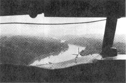
NCAR's Electra aircraft flying low over the Rajang River in Borneo -
one of the most difficult aspects of the research plan.
(Photo courtesy Anthony Delany)
|
Joachim Kuettner and Christine Guzy
preparing for departure to Malaysia.
(Photo courtesy Robert Bumpas)
|
SCIENTIFIC OBJECTIVES
The overall objectives of W-MONEX were to determine the thermodynamical and dynamical mechanisms responsible for the maintenance of the planetary circulation of the winter monsoon, namely diagnostic studies of the following:
I. Planetary-scale Aspects and Heat Sources: (1) Planetary circulations [Hadley type circulation, east-west planetary circulation, and equatorial trough; and (2) Heat sources and the effects of orography on the radiation balance];
II. Synoptic Scale Regional Aspects: (1) The cold surges; (2) The near-equatorial disturbances; and (3) The eastward moving upper tropospheric trough;
III. Interactions on the Planetary and Synoptic Scale: (1) Interactions between the Northern and Southern Hemispheric planetary scale circulation systems; (2) Interaction between planetary scale mid-latitude circulation systems and equatorial disturbances; (3) Interactions between planetary scale equatorial circulation systems and equatorial disturbances; and (4) Interactions between equatorial disturbances and stratospheric circulations;
IV. Numerical Simulation and Prediction: (1) Regional forecast problems [cold surges, equatorial disturbances, heavy rain periods, and dry spells]; and (2) Global Prediction, i.e. numerical forecasts of the general circulation and its modulation by the Winter Monsoon.
 |
OBSERVATIONS
| Aircraft | NCAR Electra, NOAA P-3 |
|---|---|
| Oceanographic | Marine surface data from research ships and ships of opportunity |
| Oceanographic | Sea surface temperature from TIROS-N satellite |
| Radar | MIT Doppler radar system deployed at Bintulu in eastern Malaysia |
| Radar | NOAA P-3 aircraft |
| Satellite | Japanese Geostationary Meteorological Satellite (GMS), U.S. TIROS-N polar orbiting satellite |
| Ship | 3 Soviet ships in the South China Sea |
| Surface | World Weather Watch Surface Observational System for FGGE |
| Surface | Portable surface stations covering 7 islands in the South China and Java Seas |
| Surface | Special datasets: agrometeorology, rainfall, and surface radiation |
| Upper Air | 3 portable stations deployed on islands in the South China Sea |
| Upper Air | World Weather Watch Upper-air Network Stations (most 2 releases daily) |
| Upper Air | Radiosonde releases from the Soviet ships |
| Upper Air | Dropwindsondes deployed from the NCAR Electra and NOAA P-3 |
NETWORK MAP
 |
All photos copyright University Corporation for Atmospheric Research unless otherwise noted.
Principal Investigators:
Data Manager:
-
EOL Archive NCAR/EOL/DMS