STAR
Storm Studies in the Arctic
The Storm Studies in the Arctic (STAR) Program was the first of its kind in the eastern Canadian Arctic, concerned with the documentation, better understanding, and prediction of meteorological and related hazards in the Arctic, including their modification by local topography and land–sea-ice–ocean transitions, their effects on the local communities, and information that may lead to an assessment of hazard frequency relative to a changing climate. The overall objective of this 4-yr program (2007–2010) was to better understand severe arctic storms and their associated hazardous conditions, and to contribute to their better prediction. The field phase was conducted between 10 October and 30 November 2007 (autumn campaign) and in February 2008 (winter campaign). Sixteen IOPs were conducted, covering a variety of weather situations and mesoscale phenomena over the region.
The majority of the enhanced detailed measurements were made in the vicinity of Iqaluit, Nunavut, although storms affecting other communities on southern Baffin Island were also of interest. Some enhanced measurements were also made at Pangnirtung, Nunavut.
STAR was primarily funded through a network grant from the Canadian Foundation for Climate and Atmospheric Sciences (CFCAS). Financial and equipment infrastructure support was provided from the Natural Sciences and Engineering Research Council (NSERC), Canada Foundation for Innovation (CFI), and the Northern Scientific Training Program (NSTP). There were 6 investigators based at 4 universities, 8 collaborators from 5 divisions of Environment Canada (EC), and the National Research Council (NRC) of Canada. Northern Canadian Partners included Nunavut Research Institute (NRI), Nunavut Arctic College (NAC), Indian and Northern Affairs Canada (INAC), Qulliq Energy, and the Nunavut Department of Education.
Scientific Objectives:
The primary motivation for STAR was the various forecasting and modeling issues that were evident in the Arctic, most of which are caused by storm–topography interactions and the seasonal variation of heterogeneous surface conditions (sea ice versus open water). Forecasting was made even more complicated by the data-sparse nature of the region’s operational weather observing network. The following issues were identified by the Prairie and Arctic Storm Prediction Centre (PASPC) as challenges in forecasting and modeling high-impact weather in the Baffin Island region: (1) Winds (wind speed and/or direction forecasts); (2) Timing of frontal passages (Interaction of synoptic-scale systems and fronts with local topography and transitions from locally to synoptically forced flow); (3) Upslope precipitation (precipitation intensity associated with upslope flow); and (4) Weather elements (hazardous weather conditions linked with low visibility, blowing snow, and aviation-related issues such as icing, ceiling height, and wind shear).
The objectives were realized through a focus on four themes: (1) Hazardous weather-related conditions in the Iqaluit area; 2) Regional hazardous weather-related conditions and sea ice effects; 3) Prediction capabilities and improvements; and 4) Interaction with the user community. Three main hazards that were investigated included: 1) Blizzards, blowing snow, and reduced visibility; 2) Storms producing snow and mixed-phase precipitation with significant accumulation; and 3) Storms, strong winds, and their effect on sea ice.
Facilities:
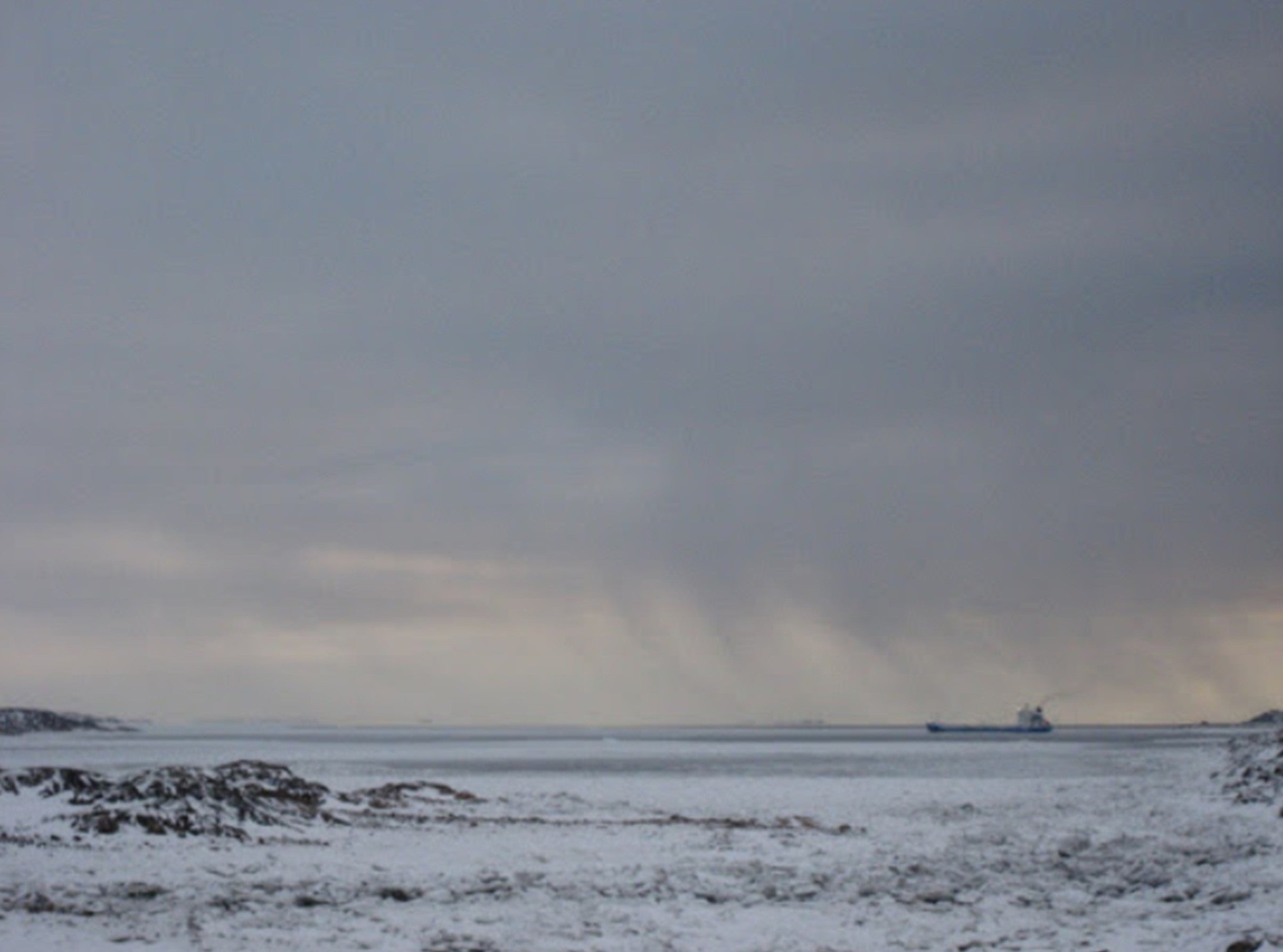
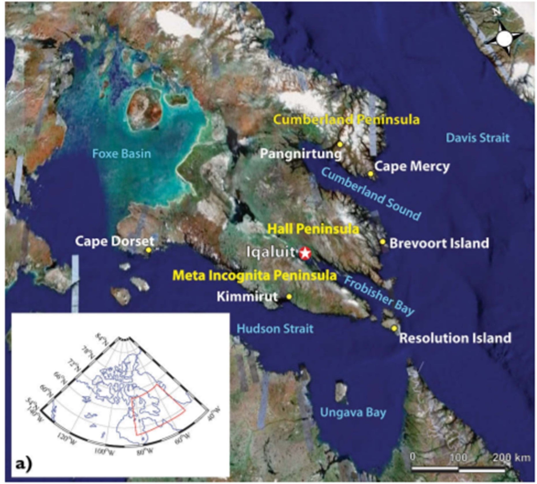
STAR was geographically focused on the southern Baffin Island region of Nunavut, Canada as shown on the map below. The area around Frobisher Bay on southern Baffin Island is dominated by two mountain ranges. These mountains have a strong effect on the surface weather near coastal communities such as Iqaluit.
Arctic storms and severe weather were sampled using standard meteorological field measurements and remote sensing. Measurements were collected during two campaigns in Autumn 2007 (10 October–30 November) and Winter 2008 (primarily 1–29 February). The base for surface observations was the EC office in Iqaluit. Meteorological instruments were installed during the last week of September and remained operational throughout the autumn field campaign. Certain instrumentation remained in the field for both the autumn storm and winter blowing snow projects.
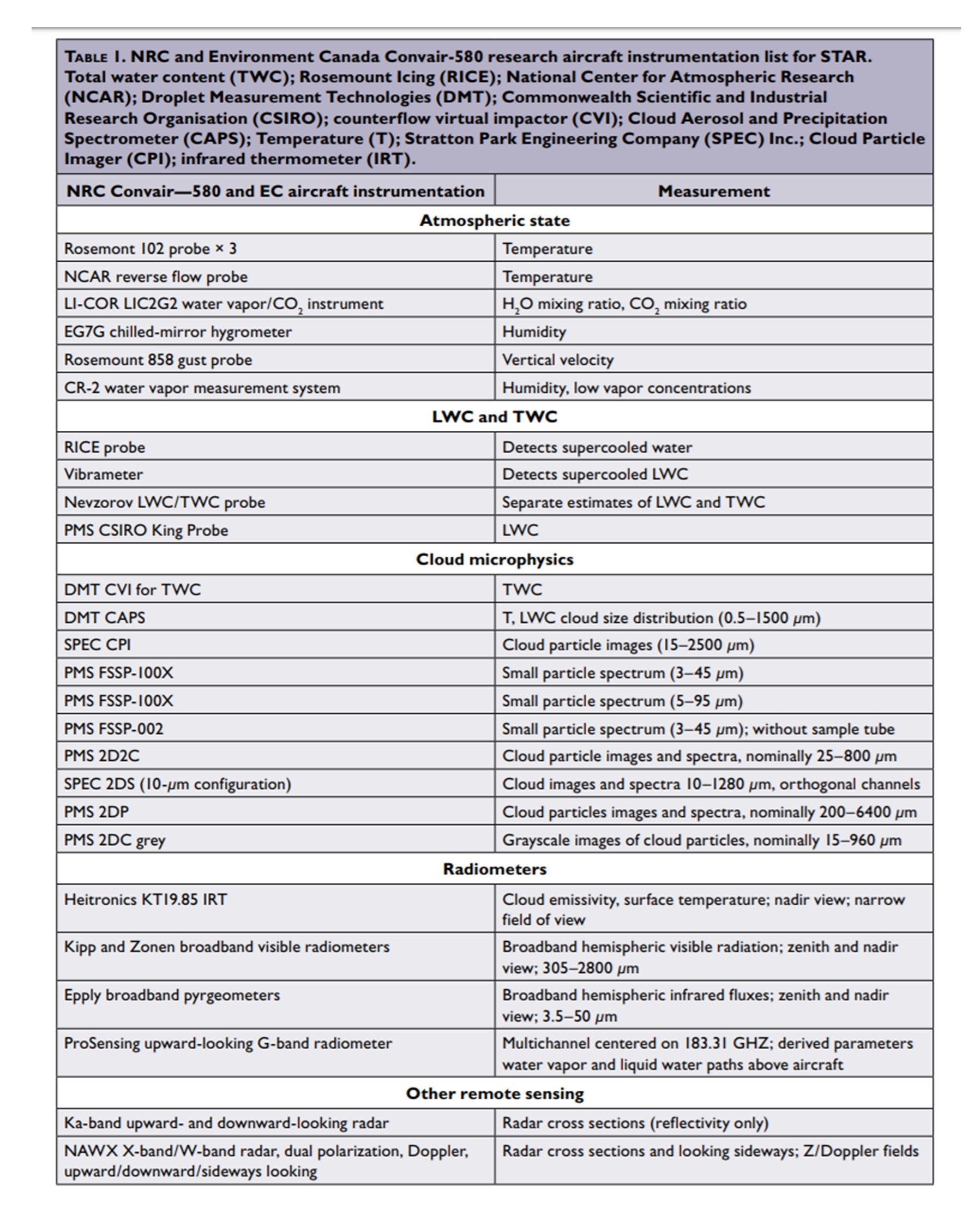
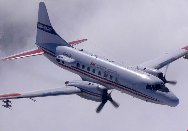
Aircraft - The NRC Convair-580 research aircraft was instrumented by EC and NRC to collect internal storm measurements of cloud microphysics, thermodynamics, wind, and the 4D dynamic and precipitation structures of storms within a 500-km radius of Iqaluit from 5 to 30 November 2007. A list of the Convair-580 instrumentation is included here. The aircraft enabled STAR scientists to probe storms as they approached the region as well as during their passage through and departure from the study area. The aircraft also provided sensor validation flights for Cloudsat satellite overpasses in the Arctic. The NRC aircraft flew approximately 48 hours during the project. This time was divided between 14 missions with variable objectives, with a total of 56 dropsondes being deployed during nine of these aircraft flights.
Surface-based remote sensing observations – Since no operational radars existed in northern Canada, a portable X-band Doppler radar was deployed at the EC office in Iqaluit (10 October–30 November 2007). This instrument was used in real time to map precipitation and wind fields within a radius of approximately 50 km of Iqaluit. It was also used to validate satellite (e.g., Cloudsat) and surface-based precipitation measurements. The radar was run in a series of four scan modes—plan position indicator (PPI), volume scans, RHI, and vertical stare—with one full cycle repeated every 15 minutes. A passive microwave radiometer (Radiometrics WVR-1100) provided time series measurements of column-integrated water vapor and liquid water content over Iqaluit. The radiometer operated looking upward, at a sampling resolution of about 1-min, from 10 October to 30 November 2007. An acoustic Doppler sodar system (Remtech PA1-NT) was also deployed at Iqaluit to assess three component winds from 0 to 1.2 km AGL, with a 30-m vertical resolution, every 30-min during 10 October–30 November 2007.
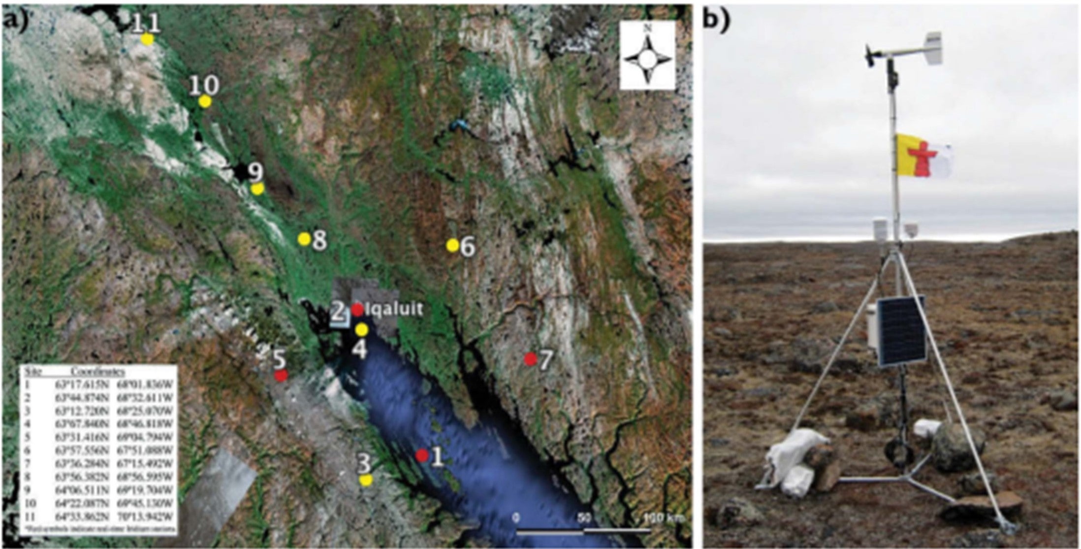
Weather station mesonet - A small mesonet of 10 automatic weather stations was deployed within a 100-km radius of Iqaluit. Nine of these stations (all except station 2) measured 3-m wind velocity, pressure, 2-m temperature, and 2-m humidity every 10 minutes. The weather stations were positioned over various forms of topography to assess storm influences on surface weather. Through collaborations with local northern groups, Indian and Northern Affairs Canada (INAC), and Qulliq Energy Corporation, four of the stations provided near-real-time data. One of the 10 stations was a standard 10-m tower at the EC site in Iqaluit (station 2). This tower was equipped with similar instrumentation as the other stations, but it also had anemometers at stations 10, 4, 3, 2, and 1, two Sentry visibility sensors, and vertical temperature gradient measurements. In addition to the 10 stations, two automatic weather stations were deployed: one in Pangnirtung, from 13 October to 18 November 2007; and another on the fast ice in Frobisher Bay (station 4). The latter station was collocated with an ice motion Global Positioning System (GPS) buoy, once ice conditions permitted (December 2007–May 2008). Besides air temperature, humidity, and wind sensors, the fast ice station was outfitted with thermocouples to profile the snow and ice, and upwelling shortwave and longwave radiation. The mesonet weather stations were operational during both autumn and winter field campaigns and were dismantled by mid-April 2008, except for the four real-time stations and the fast ice station. As part of STAR’s commitment to long-term research and support for northern communities, the four real-time stations were left for continued use by INAC and Qulliq Energy.
Special surface observations - Special instruments were set up at the EC Iqaluit office site augmented other instrumentation. STAR collaborated with EC to construct a double-fence facility with a Genore snow measurement system. In conjunction with gauge precipitation measurements, a Thies Clima laser precipitation sensor was used for providing 1-min averaged precipitation type, size distribution, and fall velocity. Further analysis of precipitation was conducted using a high-resolution digital microphotography camera. The fast ice weather and ice station provided information on the geophysical and thermodynamic state of the snow-covered sea ice throughout the winter and spring periods. Students from the NAC and the NRI collected data on snow thickness, density, and grain size as well as time series records of ice thickness. During the February winter program, several instruments were used at the EC Iqaluit site in association with the 10-m tower and visibility instrumentation, to focus primarily on blowing snow events. Blowing snow particle counters were deployed including a camera system to also measure the size distribution of blowing snow particles. An electric field mill was used to measure the strength of the electric field generated by the electrostatic charging of blowing snow particles. Blowing snow mass flux was measured using an array of snow traps, and density measurements of the snow surface were made throughout the study.
Data and Operations:
The STAR weather/logistics office was located at the Iqaluit EC Office. It had four main purposes: to make decisions on project operations, to communicate these decisions to participants, to archive data and coordinate rudimentary analysis during the project, and to maintain a log of activities. Logistics and flight planning meetings took place twice daily; once in the morning (usually 1000 EDT) to coordinate the day’s activities and another in the evening (typically 1900–2000 EDT) to discuss the next day’s expected activities. Meeting times were adjusted and supplemented depending on storm events, flight times, and flight duration.
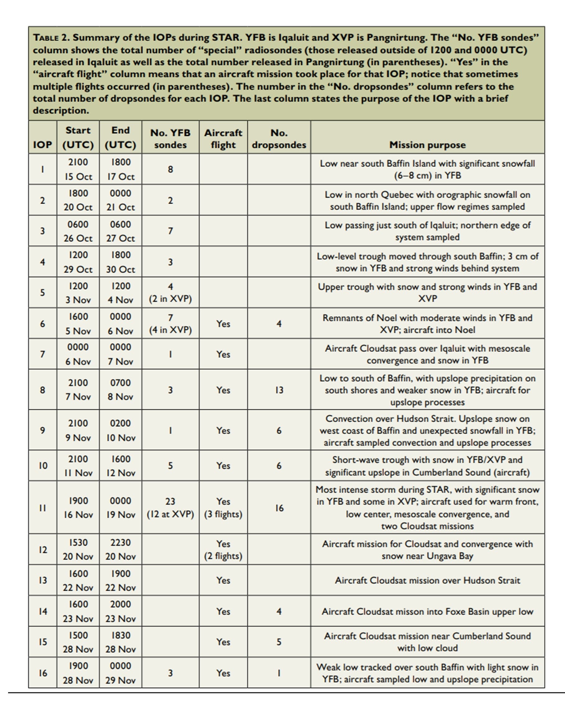
Sixteen IOPs were conducted during the Autumn 2007 field phase of STAR. Details of each IOP including start/stop times, number of special rawinsondes released in Iqaluit and Pangnirtung, aircraft flights, number of dropsondes, and mission purpose are provided here.
| Aircraft | NRC Convair 580 |
| Electrification | Electric field mill at Iquluit |
| Model | Canadian operational GEM 15-km horizontal resolution model; GEM-LAM nonhydrostatic 2.5-km horizontal resolution model over the STAR domain; University of Toronto Research Mesoscale Model (MM5, version 5) forecast model products |
| Radar | Portable X-band Doppler radar at Iqaluit |
| Radiometer | Passive microwave radiometer (Radiometrics WVR-1100) at Iqaluit |
| Satellite | NOAA Polar Orbiting; Cloudsat |
| Sodar | Acoustic Doppler sodar system (Remtech PA1-NT) at Iqaluit |
| Surface | Special mesonet of 10 automatic weather stations near Iqaluit; 10-m tower at Iqaluit; Automatic weather station in Pangnirtung; Automatic weather station on the fast ice in Frobisher Bay |
| Upper Air | EC Iqaluit 00 and 12 UTC rawinsonde releases; Special rawinsonde releases at Iqaluit and Pangnirtung |
Further information and details on STAR (described above) can be found at:
Hanesiak, J., R. Stewart, P. Taylor, K. Moore, D. Barber, G. McBean, W. Strapp, M. Wolde, R. Goodson, E. Hudson, D. Hudak, J. Scott, G. Liu, J. Gilligan, S. Biswas, D. Desjardins, R. Dyck, S. Fargey, R. Field, G. Gascon, M. Gordon, H. Greene, C. Hay, W. Henson, K. Hochheim, A. Laplante, R. Martin, M.A. Melzer, and S. Zhang, 2010: Storm Studies in the Arctic (STAR). Bull. Amer. Meteor. Soc., 91, 47–68, https://doi.org/10.1175/2009BAMS2693.1
Data Manager
EOL Archive, NCAR/EOL/DMS