SPACE-77
South Park Area Cumulus Experiment – 1977
The 1977 South Park Area Cumulus Experiment (SPACE-77) was a comprehensive summertime meteorological field program conducted in the Colorado mountains (July and August 1977) by Colorado State University (CSU) and NCAR. The location of the project was South Park, a high altitude broad basin (approximately 50-km wide, east-west) between the Mosquito Range and the Front Range of the Rocky Mountains about 100 km SW of Denver. The main area of interest were the valleys of the South Platte River and its tributaries, several of which flow through this region identified by “Central South Park”. Thus, upslope or up-valley winds are generally from a southerly through easterly direction, while downslope or down-valley winds blow from the north or west. Cumulus and cumulonimbus clouds form with great regularity within this relatively small area.
The primary objective of SPACE-77 (as a follow-on to earlier similar but smaller campaigns in this area conducted by CSU in 1973, 1974, and 1975) was to investigate the initiation, development, and propagation of cumulus congestus and cumulonimbus clouds in the mountains and the subsequent organization of these clouds into mesoscale systems. Another objective was to study aspects of the mountain boundary layer (which becomes the sub-cloud layer when clouds form) and the dry-convective mesoscale circulations which contribute to the initiation, growth, and movement of cumulus clouds. A third objective was to provide data for developing and testing numerical models of the boundary layer, cumulus clouds, and mesoscale systems over mountainous terrain.
PROJECT OPERATIONS
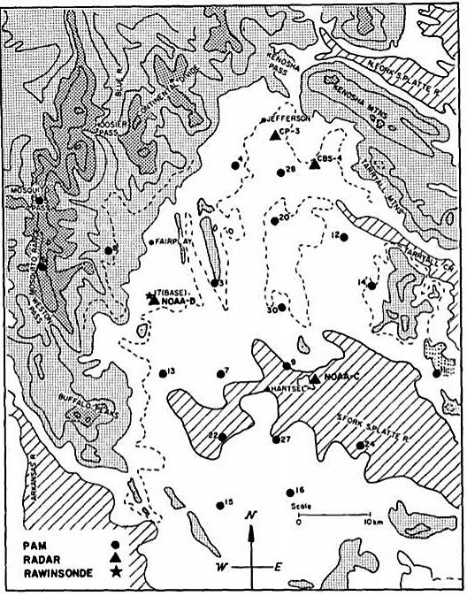
The instrumentation used in this project included a Tethersonde (tethered-balloon sounding system), the NCAR Portable Automated Mesonet (PAM) system, two (2) NCAR aircraft, rawinsonde, three (3) Doppler radars, lidar, and micrometeorological towers equipped with 3-D wind and temperature sensors (see Network Map). The Base Site for this project was located about 9 km south of Fairplay, CO, established on the east-facing slope of the Mosquito Range. Facilities located at the Base Site included the rawinsonde, two (2) Tethersonde launching sites (provided by Atmospheric Instrumentation Research, Inc.), the communications trailer for the PAM, the micrometeorological towers, ground communication for the aircraft, a Doppler acoustic sounder, radar, and NOAA lidar system (including 1-cm radar and large array of radiation sensors). The Larger tower was 23-m tall with 2 levels (top and 9-m) and the smaller tower was 15-m with 2 levels (top and 1-m). Rawinsondes were released daily at 1200, 1600, and 1900 GMT. On selected days of interest, rawinsondes were also released at 2300 and 0300 GMT.
The 20 station PAM network was deployed roughly on a 10 x 10 km grid, with 3 stations located high on the ridge top of the Mosquito Range. The PAM network measured winds at 4-m, humidity and pressure at 2-m, and rainfall at the surface (0.24mm resolution). PAM data was collected at 1-min temporal resolution.
Triple Doppler radar data were obtained from two (2) NOAA 3.2-cm wavelength (X-band), and the NCAR CP-3 5.5 cm (C-band). NOAA-2 was located at the Base Site, NOAA-1 was 27 km SE of the Base Site, and CP-3 was 30-km NE. After 1 August, the 10-cm CSU FPS-18 radar collected full volume scans on higher ground about 7 km SE of CP-3.
The NCAR twin-engine Queen Air (Tail number 304D) was equipped with a gust probe as well as standard meteorological instruments. The Queen Air flew “butterfly” patterns at several different levels, with flight legs of 33 x 37 km centered on the Base Site, mostly in mornings during 10-31 July (14 flights). The NCAR Sailplane flew cloud penetrations during July and August in coordination with the Lidar system and Doppler radars. Sailplane flights were also coordinated with two (2) Bureau of Reclamation (BUREC) cloud physics aircraft (from the concurrent High Plains Experiment (HIPLEX) program), which flew cloud penetration, first echo studies, and small mesoscale patterns during August.
OBSERVATIONS/DATA
In conjunction with HIPLEX, the SPACE-77 also gathered data over a region approximately 500 km (east to west) by 200 km (north to south) extending from west of South Park to east of Goodland, KS. Three rawinsondes were released daily from Limon, CO, usually at 12, 19, and 00 GMT. In addition, several rawinsondes were released from Goodland by HIPLEX personnel. These were supplemented by NWS soundings at Denver and Grand Junction, CO. Other ancillary data collected included Satellite, NWS radar, and other conventional surface observations in the area.
| Aircraft | NCAR Queen Air and NCAR Sailplane |
|---|---|
| Aircraft | Two (2) BUREC Cloud Physics aircraft from HIPLEX Program (August only) |
| Lidar | NOAA lidar system (including 1-cm radar and large array of radiation sensors) |
| Radar | NCAR C-band (CP-3), and two (2) NOAA X-band Doppler Radars |
| Radar | NWS WSR-57 Radars at Denver and Limon, CO |
| Radar | CSU 10-cm FPS-18 radar (August only) |
| Satellite | GOES Imagery (visible and infrared) including two days of “rapid scan” (3 or 9-min intervals) |
| Surface | 20 NCAR PAM stations |
| Surface | Two (2) micrometeorological towers at Base Site (winds and temperature) |
| Surface | Conventional surface weather observations from existing stations in the area |
| Upper Air | Special daily rawinsonde releases from Base Site. |
| Upper Air | Two (2) Tethersonde balloon sounding systems at Base Site |
| Upper Air | Doppler acoustic sounder at Base Site |
| Upper Air | NWS rawinsonde at Denver and Grand Junction, CO (nominal daily 00 and 12 GMT releases plus special supplementary releases as requested. |
NETWORK MAP
 |
- EOL Archive NCAR/EOL/DMS