RELAMPAGO
Remote sensing of Electrification, Lightning, And Mesoscale/microscale Processes with Adaptive Ground Observations
The RELAMPAGO field program will have two phases, with an Extended Hydrometeorology Observing Period (EHOP) from 1 June 2018 – 30 April 2019 and an Intensive Observing Period (IOP) from 1 November – 15 December 2018. A dry run campaign will be conducted in November 2017. The project will take place in west central Argentina in the general vicinity of the Sierras de Córdoba (SDC) near Córdoba and the Andes foothills near Mendoza.
RELAMPAGO will provide unique observations of atmospheric and surface conditions in a region with substantial terrain and explore a regime of convection not observed comprehensively. RELAMPAGO will form a key part of an observation network that will elucidate the tight connections between the land surface, complex terrain, convective development, and the production of severe weather, role of terrain processes in initiating and developing organized convective systems and altering flows within and above the convective boundary layer, and roles of environmental moisture, aerosols, and instability on the resultant intensity, organization, precipitation, and high impact weather production of deep convective systems. Through its unique configuration of atmospheric profiling and remote sensing capabilities, understanding of processes that impact prediction of societal hazards will be improved.
ISFS Tower Locations
Columns 3-5 came from a cell phone during the site survey.
| Site number | Nearest town | Latitude | Longitude | Elevation (m) |
|---|---|---|---|---|
| S1 | Rio Primero | 31° 19.877'S | 63° 38.470'W | 253 |
| S2 | El Tio | 31° 22.856'S | 62° 48.640'W | 116 |
| S3 | San Francisco | 31° 25.654'S | 62° 7.963'W | 116 |
| S4 | Esperanza | 31° 23.501'S | 60° 54.689'W | 25 |
| S5 | Canada de Gomez | 32° 48.341'S | 61° 26.097'W | 97 |
| S6 | Marcos Juarez | 32° 43.423'S | 62° 5.625'W | 115 |
| S7 | Marcos Juarez | 32° 42.947'S | 62° 4.478'W | 112 |
| S8 | Ordonez | 32° 48.216'S | 62° 57.615'W | 147 |
| S9 | Ordonez | 32° 50.325'S | 62° 53.111'W | 133 |
| S10 | Laborde | 33° 9.335'S | 62° 49.405'W | 123 |
| S11 | La Carlota | 33° 18.288'S | 63° 21.312'W | 157 |
| S12 | Alejandro Roca | 33° 24.199'S | 63° 38.206'W | 191 |
| S13 | Rio Cuarto; Campo Pozo del Carril | 32° 58.048'S | 64° 39.136'W | 646 |
| S14 | Berrotaran | 32° 28.334'S | 64° 23.708'W | 631 |
| S15 | Pilar | 31° 40.078'S | 63° 52.924'W | 335 |
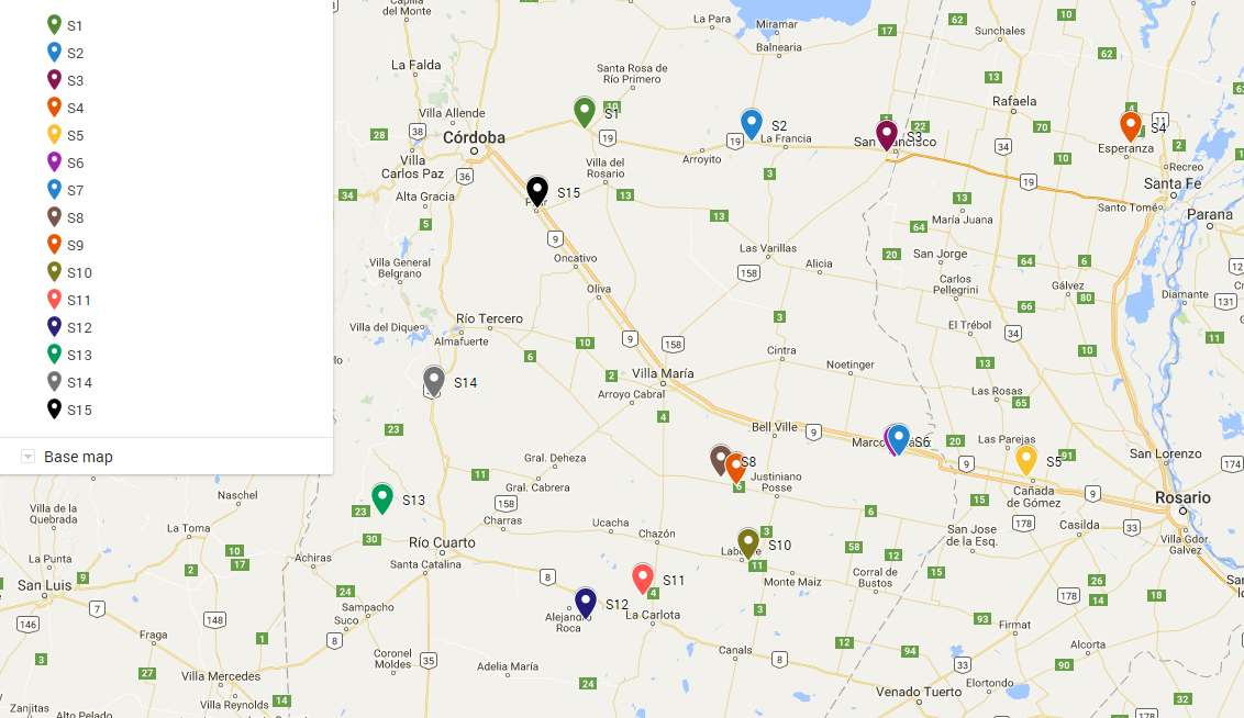
Relampago ISFS tower site map in Argentina.
Principal Investigators
Steve Nesbitt U of Illinois
Rita Roberts NCAR
Jeff Trapp U of Illinois
Francina Dominguez, U of Illinois (Hydromet)
David Gochis, NCAR (Hydromet)
Data Manager
EOL Archive NCAR/EOL/DMS