REFRACTT06
Refractivity Experiment For H2O Research And Collaborative operational Technology Transfer '06
REFRACTT is the Refractivity Experiment For H2O Research And Collaborative operational Technology Transfer. The field phase will be conducted from 5 June to 11 August 2006 in northeastern Colorado.
Goals
REFRACTT includes scientific research and operational application goals. Both have the goal of greatly enhancing the observed field of water vapor over the nation thus leading to improved precipitation forecasts
The scientific goal is to utilize multiple radars and GPS receivers to simultaneously obtain very high resolution measurements of water vapor variability and transport in the convective boundary layer and to assess potential improvements these enhanced water vapor measurements may have in numerical model forecasts of quantitative precipitation.
The application's goal is to demonstrate the ability to collect radar refractivity data on the NEXRAD (WSR-88D) radars and to demonstrate the forecast value of this field to NWS forecasters. The ultimate goal is to implement radar refractivity measurements on the national network of operational radars.
Hypotheses
- High temporal and spatial resolution of near surface observations of water vapor will improve short term convective storm forecasting and quantitative precipitation forecasting.
- 3-dimensinonal water vapor measurements obtained from combining radar refractivity and GPS slant range measurements will improve convective storm and quantitative precipitation forecasts.
- Near-surface water vapor measurements will enhance our understanding of the exchange of moisture among soil/vegetation, land-surface, and boundary layer and determine the degree to which the boundary-layer moisture heterogeneity is related to land-surface heterogeneity.
- The implementation of radar refractivity measurements on the national network of WSR-88D's with the new open radar data processor will be inexpensive and non-intrusive to other radar activities.
- Accurate, path integrated, moisture estimates in the boundary layer can be obtained from dual-wavelength radar reflectivity measurements of clouds, resulting in horizontal and vertical moisture distributions.
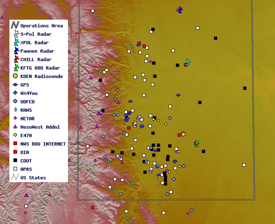
Instrumentation
Time series phase information will be collected from four radars, CSU's CHILL and Pawnee radars, the NCAR S-PolKa radar and the NWS Denver NEXRAD (KFTG) radar to produce refractivity fields.
In Colorado, there are approximately 15 GPS receivers located along the Front Range and over the High Plains of NE Colorado. Another 4 stations are planned in time for the field phase for a total network of 19 GPS receivers.
The NCAR Mobile GPS Advanced Upper-Air Sounding System (MGAUS) will be deployed to specific locations to obtain soundings on either side of tight horizontal water vapor gradients and to a variety of other locations to help obtain representative measures of vertical water vapor profiles to correlate with the near surface refractivity measurements.
Additionally, there is the possibility of using ENVISAT ASAR (Advanced Synthetic Aperture Radar) data to measure refractivity from space. There may be two opportunities during the field phase to have satellite overpasses (14 June and 19 July). Click here for further information about the ENVISAT overpasses.
Additional possible instrumentation includes the DIAL Lidar, two Mini Radiometers, two Corner Reflectors, an NCAR Disdrometer, the CASA X-Band Radar, and the rapid scan Doppler on Wheels (DOW).
Data Manager:
- Bob Rilling NCAR/EOL/RSF
- EOL Archive, NCAR/EOL/DMS