PRE-STORM
Preliminary Regional Experiment for STORM-Central
Field operations for the Oklahoma-Kansas Preliminary Regional Experiment for STORM-Central (PRE-STORM) took place from 1 May to 30 June 1985 in the Central United States. The broad objectives of this study were to deploy, operate, and coordinate the efforts of a large collection of measurement systems over a regional area as a preliminary shakeout of techniques to be utilized in the full-scale U.S. Weather Research Program (USWRP) STormscale Operational and Research Meteorology (STORM) Program, and to investigate the structure and dynamics of Mesoscale Convective Systems (MCSs). A number of sensing systems, including Doppler radars, digitized radars, surface mesonetwork stations, supplemental and National Weather Service (NWS) rawinsondes, wind profilers, a lightning location system, satellite products, and research aircraft were brought together to collect the data necessary to begin the investigations of MCSs. At the same time, testing and evaluation of new sensing systems, such as profilers and airborne Doppler radar, were carried out to determine how best to operate them in a coordinated observing system. A separate Research Program sponsored by the Department of Energy (DOE) called PRECP (Processing of Emissions by Clouds and Precipitation) was conducted during June in conjunction with PRE-STORM.
Major partners participating in PRE-STORM included the USWRP, National Oceanic and Atmospheric Administration (NOAA) National Severe Storms Laboratory (NSSL), NOAA Office of Aircraft Operations (OAO), NOAA Environmental Research Laboratories (ERL), the National Center for Atmospheric Research (NCAR), the DOE, and ten (10) Universities, notably the University of Oklahoma (OU), University of Wyoming (UWYO), University of Wisconsin (UWI), and the Colorado State University (CSU).
SCIENTIFIC OBJECTIVES
The long-range goals of PRE-STORM are to improve, by means of improved physical understanding, the forecast of the occurrence, strength, movement, duration, rainfall, and potential for severe weather of MCSs. The major goals for the field phase of the program were to 1) achieve a reliable and coordinated integrated observing system for investigating MCSs; and 2) collect the data necessary to begin preliminary investigations of the origin, development, dissipation, and structure of MCSs. The primary focus of the program was directed toward investigating nocturnal MCSs, which typically would form in the mid-to-late afternoon and become well organized during the evening hours. Specific experiments that were planned and carried out to meet these objectives fit into four unique categories: pre-convective, genesis, mature and dissipative, and a fourth category designed to investigate the residual circulation from a dissipating large-scale convective system. Most flights and operations were carried out to investigate at least one of these categories. Studies were also carried out that allowed formulation of physical models and further refine numerical models to improve our understanding of how MCSs develop and evolve, including super-cells and storm clusters. Experiment design emulated to some degree the beta-scale network array proposed for the full-scale STORM-Central Program.
Aircraft experiments were carried out in various stages in the life cycle of an MCS. The principal goals of the aircraft program were to 1) gather aircraft data in the vicinity of developing and mature MCSs to better define their structure, evolution, physical processes, and interactions; 2) study the development of the nocturnal jet; and 3) develop and test observational strategies for optimal utilization of the Doppler radar system onboard the P-3 aircraft in the MCS environment.
PROJECT OPERATIONS
Aircraft Program - During May, one of the NOAA/OAO P-3 aircraft (Tail N-43) and the UWYO King Air aircraft were located at Oklahoma City, OK, to carry out PRE-STORM flights. At the end of May, the King Air returned to Wyoming and NOAA's second P-3 aircraft (Tail N-42) joined PRE-STORM in Oklahoma City for the second month of the project. In general, the P-3 flights focused on measuring the internal structure of MCSs as determined by the in-situ data and by the remote sensors, such as radiometers and Doppler radar. The UWYO King Air flew primarily to investigate the microphysics and flow structure of MCSs and the development of the nocturnal low-level jet. A separate research program within the National Acid Precipitation Assessment Program (NAPAP), called the PRECP program, was conducted in conjunction with PRE-STORM during June. Three aircraft (the NCAR Sabreliner, the NOAA/OAO King Air, and the DOE Brookhaven Laboratory Queen Air) were used to measure the chemical constituents of the inflow and outflow air of MCSs. At the same time, rainwater was collected from a number of surface sites in the PRE-STORM area. Data from this program was used to test the capabilities for obtaining data to evaluate the role of deep convective systems as pollutant-scavenging mechanisms.
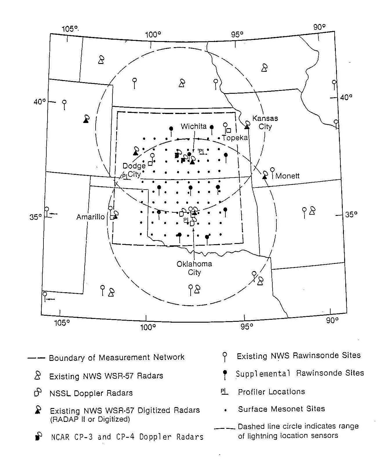
Upper Air Network – Fourteen (14) NWS rawinsonde stations took additional upper air soundings on selected operational days during the program. All sites took soundings at three-hour intervals when requested, with Oklahoma City, Dodge City, and Amarillo sites having the ability to take 90-min interval soundings when requested. During operational days, each military site operated 16 to 18 hours per day. Soundings from these sites were taken at either three-hour or at 90-min intervals.
Doppler Radars - Two Doppler-radar pairs, the NSSL 10-cm Doppler radars and the NCAR Field Observing Facility's (FOF) 5-cm Doppler radars (CP-3 and CP-4) operated in the PRE-STORM. The NSSL radars were located at fixed sites in Norman and Cimarron, OK, and the NCAR radars were located at Cheney Reservoir and Nickerson, KS (northwest of Wichita). These Doppler-radar pairs essentially operated in an independent mode, based on the meteorological situation. If an MCS was located over both radar pairs, the scanning sequence of the radars was such that similar data were collected at selected intervals in order to optimize the data for investigations of the structure and dynamics of these systems. On one of NOAA's P-3 aircraft, the 3-cm vertically scanning tail radar, had been Dopplerized. This radar was used either in conjunction with the surface Doppler radars to provide triple Doppler-radar data, or to extend the Doppler-radar coverage area.
Surveillance Radars - The second-generation Radar Data Processor (RADAP-II) program, operated by the NWS, digitized volume-scan radar data from a six (6) radar sites in the Pre-STORM domain, and recorded volume scan data (2° radial at a 1-nm gate spacing with volume scans were made at 2° increments up to a maximum height of 22°). Six volume-scans per hour were made (one scan per 10 min) with most sites providing at least two volume-scans per hour for PRE-STORM. Two radar digitizers, one from the NOAA Hurricane Research Division (HRD) and one from the NWS Training Center in Kansas City were located at Wichita, Kans. and at Kansas City, MO, respectively. The HRD digitizer was located at Wichita in order to get higher-resolution data than was available from the RADAP-II systems for support of the NCAR CP-3 and CP-4 Doppler radar data collected in that area. The digitized WSR-57 radar located at NSSL also collected volume-scan reflectivity data during the PRE-STORM. Data from this radar were recorded at each 2° radial, with a gate spacing of 1.0 km.
Wind Profiler Network - Three 50 MHz wind-profiling systems operated in Oklahoma and Kansas during the PRE-STORM. One of these systems was a NOAA Wave Propagation Laboratory (WPL) system provided to NSSL/OU. This system was operated just south of Norman, OK. A second system was provided by the NOAA Aeronomy Laboratory (AL) and operated at Liberal, KS. The third system, located at McPherson, KS, was leased from the Radian Corporation, which had obtained the Max-Planck Institute's SOUSY system. The NOAA/AL and Radian profilers were three-beam systems, and the NSSL/OU system was a two-beam system. An acoustic sounding system also operated in conjunction with the Radian profiler to provide wind data in the lowest 1 km of the atmosphere.
Surface meso-scale network – Eighty (80) surface stations were set up in the PRE-STORM area with a spacing between stations of about 50 km. Forty (40) sites were the NCAR/FOF PAM-II (Portable Automated Mesonetwork) systems and forty (40) were the NSSL SAM (Stationary Automated Mesonetwork) systems. The PAM-II sites were located primarily in Kansas, and the SAM sites were located primarily in Oklahoma. Two additional PAM systems were collocated with two SAM systems for intercomparison purposes. PAM-II data were available in real time and could be accessed and displayed.
Lightning-location system - The cloud-to-ground-lightning detection system that has been operated by NSSL over the past several years in the Oklahoma area was expanded to include much of Kansas and Nebraska and small portions of adjacent states. Three new lightning-direction finders were located in Kansas to supplement the four located in Oklahoma. Real-time data were available from these systems at both NSSL and at the PRE-STORM Operations Center.
Satellite Program - The satellite program was operated by the NOAA Development Laboratory of the National Environmental Satellite, Data, and Information Service (NESDIS) supported by CIRA (Cooperative Institute for Research in the Atmosphere), located at the Colorado State University, and by CIMSS (Cooperative Institute for Meteorological Satellite Studies), located at the UWI. Visible, infrared, VAS (VISSR [visible infrared spin scan radiometer] Atmospheric Sounder), and RISOP (Rapid Interval Scanning Operations) data were collected both to support the forecasting of MCSs, and to collect data to be used for research on MCSs. A satellite display workstation was set up and operated in PRE-STORM, in order to provide various satellite products as well as to evaluate the usefulness of these products in real time in an extensive program such as STORM.
Sixteen operational missions were carried out during the two months of the program, many of which extended into a second day, and/or investigated more than one convective system. Table 1 shows the dates, the general research area, the Doppler-radar network area that was affected, the aircraft flown with takeoff and landing times, and the number of soundings taken by the NWS and the supplemental sounding sites. On all but one day the aircraft flew as part of the operational mission. There were also a number of other days on which the Doppler radars collected data independently or in conjunction with some very limited rawinsonde support to study a specific event, or when other resources were not available because of staffing constraints. These days are not indicated in the table.
 |
OBSERVATIONS/DATA
| Aircraft | 2 NOAA P-3 Aircraft, UW King Air (May only), and 3 DOE/PRECP Aircraft [NCAR Saberliner, NOAA King Air, and DOE Brookhaven Laboratory Queen Air] |
| Radar | 4 Research Doppler Radars (2 from NSSL and 2 from NCAR), and an airborne radar on the NOAA P-3 (N-43) aircraft |
| Radar | 14 NWS Radars |
| Satellite | Routine Visible, infrared, VAS data collected with selected RISOP periods |
| Surface | 80 sites [40 from NOAA/NSSL SAM, 40 NCAR/FOF PAM-II systems, with 2 co-located stations] |
| Surface | Cloud-to-ground lightning location system operated by NOAA/NSSL |
| Surface | NADAP Rainwater collection sites |
| Upper Air | 3 Wind Profilers [Radian Corporation 3-Beam VHF phased antenna array, NOAA/OU 2-Beam, and NOAA/AL 3-Beam] |
| Upper Air | 14 NWS and 12 supplemental (military operated) rawinsonde sites |
NETWORK MAP
 |
Further information and details on PRE-STORM can be found at The Oklahoma-Kansas Preliminary Regional Experiment for STORM-Central (J.B. Cunning).
Principal Investigators:
- Steve Rutledge CSU
- Robert Houze UW
- William Cotton CSU
- Richard Johnson CSU
Data Manager:
- EOL Archive NCAR/EOL/DMS