GALE
Genesis of Atlantic Lows Experiment
The Genesis of Atlantic Lows Experiment (GALE) was a project to increase the understanding of winter storms which develop and intensify on the East Coast of the United States. The weather associated with these storms is often severe and frequently these events are poorly predicted by current numerical forecasting models. The GALE field project, the largest field study of East Coast storms to date, was designed to apply the latest facilities available for the study of meteorological phenomena (e.g. scanning Doppler radars, automated surface observing stations, new sounding systems, airborne Doppler radar) to a coordinated study of synoptic and mesoscale features of East Coast cyclones.
Because it is a scale-interaction problem, the meso-beta-scale GALE observing region was nested in a meso-alpha-scale domain of sufficient size to incorporate continental and marine components. Data collection extended west of the Appalachians, in order to evaluate the effect of orography on modifying large-scale systems or establishing meso-scale systems, and near the shore and offshore where the cyclogenesis occurs. In addition, data had to be collected with temporal resolution adequate to study the mesoscale processes.
The Canadian Atlantic Storms Program (CASP) field phase coincided in time with GALE and had similar scientific objectives. CASP was conducted by the Canadian Atmospheric Environment Service (AES), and studied winter storms along the east coast of Canada. Several, but not all, cases dealt with the same storms. Enhanced downstream observations extended into the Canadian Maritime Provinces when major cyclonic storms developed and moved into that area.
GALE support and participation was provided by 7 Federal Agencies, 15 Universities, and 2 Commercial Institutions. The GALE Project Office was located at and supported by the National Center for Atmospheric Research (NCAR).
 |
SCIENTIFIC OBJECTIVES
The objectives of GALE were to study mesoscale and air-sea interaction processes in East Coast winter storms, with particular emphasis on their contributions to cyclogenesis. The core objectives of GALE were: 1) to describe the airflow, mass, and moisture fields in East Coast winter storms with special emphasis on mesoscale processes; 2) to understand the physical mechanisms controlling the formation and rapid development of East Coast storms; 3) to develop and test numerical models for the prediction of East Coast storms.
The specific objectives that had to be carried out to fulfill the core objectives of GALE were: 1) to study the three-dimensional structure of the boundary layer and associated energy and momentum fluxes from the Gulf Stream to the Appalachian Mountains; 2) to study the mesoscale structure of fronts on the East Coast; 3) to study the role of orography with emphasis on cold air "damming" near the Appalachian Mountain range; 4) to study the spatial and temporal changes in the structure of high-level and low-level jet streaks associated with East Coast cyclones; 5) to study the mesoscale organization of convective and stratiform precipitation systems on the East Coast; 6) to perform numerical simulations of East Coast storms and the associated boundary-layer and precipitation systems for testing hypotheses concerning physical mechanisms, for providing data sets for diagnostic studies, and for evaluating parameterization methods; and 7) to use GALE data for testing and refining operational objective analyses and operational prediction models.
The supporting objectives of GALE were to study the following: 1) cloud and precipitation processes associated with East Coast cyclones, with emphasis on simultaneous radar and in situ measurements; 2) the role of gravity waves and other mechanisms in the organization of precipitation bands; 3) the evolution of stratospheric and tropospheric exchange processes in relation to rapid cyclogenesis; 4) the influence of cold-air outbreaks over the relatively warm coastal ocean on frontogenesis and cyclogenesis; 5) the response of the coastal ocean waters to winter storms and cold-air outbreaks; 6) the application of conceptual models and enhanced mesoscale data to short-range forecasting of significant weather; and 7) the subsequent evolution of major cyclones traveling northward from the GALE observational network.
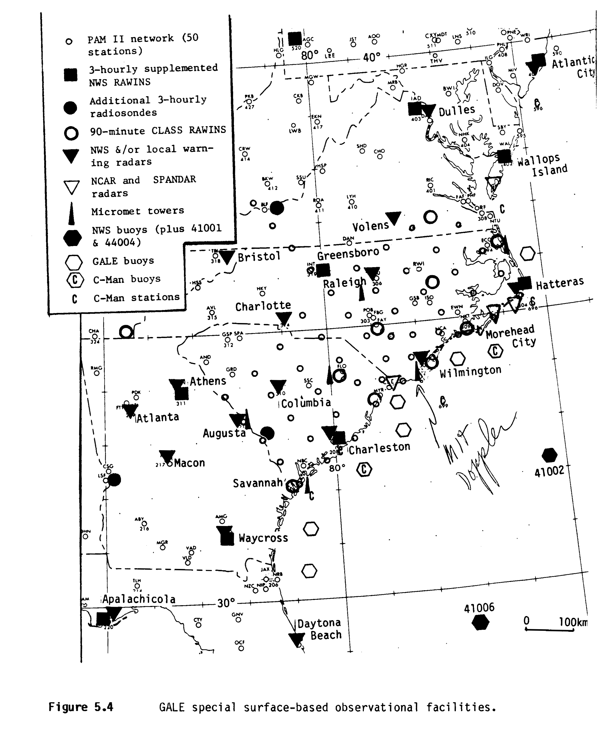
NETWORK MAP
 |
OBSERVATIONS/DATA
Three areas of particular significance to GALE were defined for reference in a description of the experimental design (as shown in the network map):
Inner GALE Area - Meso-beta processes could be resolved and local meso-gamma processes (including convective clouds, boundary-layer fluxes and microphysical processes) could be examined. The Inner GALE Area was approximately 500-km wide, centered on the coast, and extended 1000 km from Georgia to Virginia. NCAR’s Portable Automated-Mesonet (PAM-II), Doppler radars, ships, buoys, most aircraft flights and NCAR’s Cross-chain Loran Atmospheric Sounding System (CLASS) rawinsonde sites were in this area.
Regional GALE Area - Meso-alpha processes of frontogenesis and cyclogenesis could be examined. The Regional GALE Area was 1,000-km wide (from the ridge of the Appalachians to 500-km offshore), and 1,500- km long (from Florida to New Jersey). This included the area where cold-air damming and primary cyclogenesis occurred and is the framework within which processes in the Inner GALE Area occurred. Special observations in this area included intensive dropwindsondes (including USAF National Winter Storms Program), extra rawinsonde sites, airborne measurements, digitized NWS radar data, and increased observations from standard surface stations.
Outer GALE Area - The synoptic features in the cyclone and jet-stream circulations could be identified and observed with increased temporal resolution prior to their arrival and after they left the Regional GALE Area. The Outer GALE Area extended "upstream" from the Regional GALE Area to the Great Plains, from Canada to the Gulf of Mexico and "downstream" through New England. Special observations in the outer GALE Area included an increased frequency of National Weather Service (NWS) soundings, increased satellite observations, and some special aircraft flights in the jet-stream region.
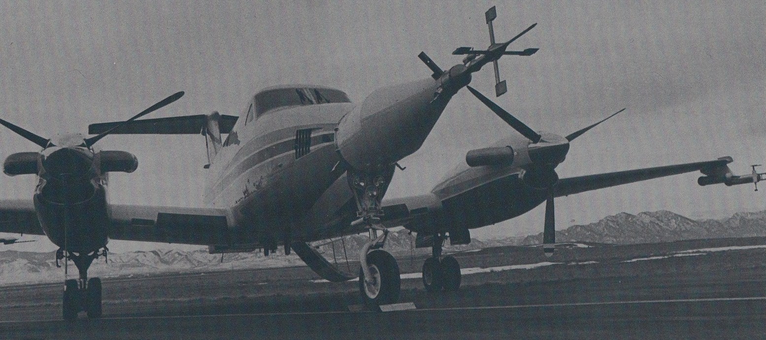
| Aircraft | NOAA P-3; NOAA Citation; NCAR Electra; NCAR Sabreliner; NCAR King Air; University of Washington Convair; NASA Electra; NASA ER-2; MIT Baron; plus the NCSU Cessna flew chaff missions. A number of dropwindsonde missions were flown by the USAF as part of the National Winter Storm Program. |
|---|---|
| Lightning | 19 SUNY Lightning Detection Stations |
| Oceanography | 8 current meters, 10 tide gauges, 8 meteorological buoys, 6 ocean platforms |
| Radar | NCAR Doppler CP-3 and CP-4 (C-band); MIT Doppler (C-band); NASA SPANDAR (S-band); University of Washington vertically pointing Doppler (K-band); NOAA P-3 airborne radars (X-band), and one non-Doppler |
| Radar | 15 NWS WSR-57/74 non-Doppler radars |
| Satellite | GOES-6, NOAA-9, NOAA-6, DMSP F-6, DMSP F-7, and NIMBUS- 7. All provided standard data products except GOES-6, which was operated in the rapid interval scan operations (RISOP) mode |
| Ships | R/V Cape Hatteras and R/V Endeavor as well as ships of opportunity |
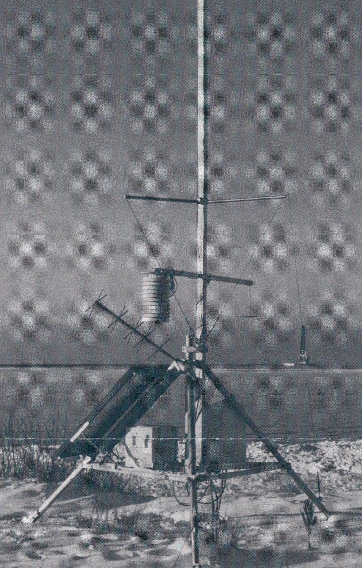
| Surface | 50 NCAR PAM-II stations; 4 micrometeorological towers; 2 agricultural networks; 40 DOD military stations; and East Coast volunteer snowfall observer network |
| Upper Air | 39 NWS sites (3-h intervals upon request); 7 NCAR CLASS systems (1.5-h intervals upon request); 9 additional land-based sites; 2 ship-based systems); and dropwinsondes deployed by NOAA, USAF, and NCAR (Atlantic and Gulf of Mexico) |
PROJECT OPERATIONS
The GALE Operations Center was located at the Raleigh-Durham Airport (RDU). The GALE Operations Forecast Center (OFC) was co-located with the Raleigh Weather Service Forecast Office (WSFO). The OFC was the focal point for transmission of all routine and special meteorological data for both operational and archiving purposes. The OFC provided both long-range forecasts for scientific planning purposes and nowcasting for aircraft and ship operations. Special support for long-range forecasts was provided by the National Meteorological Center (NMC).
The GALE Operations Control Center (OCC), located in a temporary structure adjacent to the Raleigh WSFO, was the communications and control center for all field operations. Activities included the directing of aircraft and other operational decisions with the assistance of FAA and military controllers. The day-to-day selection of scientific missions was made by the Mission Planning Team (MPT). The MPT was responsible for the overall guidance of the field program and the fulfillment of the scientific objectives. Highly coordinated aircraft and Doppler-radar operations in the coastal region were carried out at the dual-Doppler-radar location at Cape Hatteras. This location also served as an emergency back-up control center.
 |
|
GALE PAM Station (Photo courtesy of NCAR)
|
Periods during which high-resolution observations were made were referred to as Intensive Observing Periods (IOPs). Routine observational systems, such as the existing NWS rawinsonde network were called upon to increase their frequency of observations. "Fixed" special observing systems, such as the Doppler radars and satellites were operated in selected modes. Mobile observing systems, such as the aircraft and ships, were deployed into areas of special interest.
Major IOPs required 24-h prediction in order to alert some components of the observing systems 12 h to 24 h in advance. Some components also required advance notice of the end of an IOP. Because some local weather events were difficult to predict, the operations plan permitted quick response of more limited observing systems to these events. These quick-response IOPs generally involved only the special mesoscale observing systems located within the Regional GALE Area.
There were thirteen (13) special observing periods during the field phase extending over about 36 days including eight cases of cyclogenesis. Nine (9) aircraft flew nearly 900 hours, two (2) research vessels participated on a total of 80 days, and about 4,000 special soundings were released including 1,500 releases at 3-h intervals. Approximately 500 soundings (rawinsonde and dropwindsondes) were made over the Atlantic coastal waters. Meteorological and oceanographic phenomena on which special observations were collected include: cyclogenesis, rainbands, cold fronts, coastal fronts, cold-air damming, jet streaks, tropopause folding, low-level jets, cold-air outbreaks, lightning and marine boundary layer interactions with Gulf Stream and mid-shelf oceanic fronts.
Further information and details on GALE can be found at GALE: An Overview (R. A. Dirks, J.P. Kuettner, & J.A. Moore).
All photos copyright University Corporation for Atmospheric Research unless otherwise noted.
Principal Investigators:
- Carl W. Kreitzberg
- S. SethuRaman
- Ronald B. Smith
- Peter V. Hobbs
Project Manager:
- Paul Spyers-Duran
Data Manager:
- EOL Archive NCAR/EOL/DMS