FIRE-Stratocumulus
First ISLSCP Regional Experiment – Stratocumulus
The overall goal of the International Satellite Land Surface Climatology Project (ISLSCP) was to improve the understanding of satellite measurements relating particularly to the fluxes of momentum, heat, water vapor, and carbon dioxide from land surfaces. The First ISLSCP Regional Experiment (FIRE) Intensive Field Observations (IFO) data gathering component consisted of separate field campaigns to study cirrus clouds over the mid-continent U.S. (Wisconsin, 1986), and marine stratocumulus clouds off the southwestern coast of California in the vicinity of San Nicolas Island from 29 June to 19 July 1987. The FIRE Marine Stratocumulus IFO (aka FIRE-Stratocumulus) was conducted to support research tasks requiring high time and space resolution of marine stratus and stratocumulus cloud systems as well as the development of parametrizations of cloud-scale processes, climate-scale based variables, and a better understanding of International Satellite Cloud Climatology Project (ISCCP) data products. FIRE-Stratocumulus represented the most comprehensive stratocumulus observing campaign (coordinated satellite, airborne, upper air, and surface-based measurements) in conjunction with the DYCOMS (Dynamics and Chemistry of Marine Stratocumulus) program, both past (1985) and future field deployments.
Project participants for FIRE-Stratocumulus included the National Aeronautics and Space Administration (NASA), National Oceanic and Atmospheric Administration (NOAA), National Center for Atmospheric Research (NCAR), U.S. Navy, British Meteorological Office (BMO), University of Washington (UW), Pennsylvania State University (PSU), and Colorado State University (CSU).
Scientific Objectives:
The primary objective of FIRE were to: (1) seek the basic understanding of the interaction of physical processes in determining life cycles of cirrus and stratocumulus systems and the radiative properties of these clouds during their lifecycles; and (2) investigate the interrelationships between the ISCCP data, Global Climate Model (GCM) parameterizations, and higher space and time resolution cloud data.
The specific observational objectives of FIRE-Stratocumulus were to: (1) determine the large-scale structure of clouds and the surrounding meteorological environment; and (2) characterize the fine scale microphysical, radiative, dynamic, and structure of marine stratocumulus clouds, with emphasis on multiple angular and spectral observations and characterization of the marine stratocumulus life cycle.
Observations:
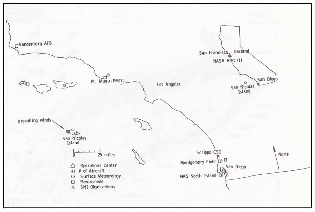
The FIRE-Stratocumulus Operations and Forecast Center was located at the North Island Naval Air Station (NAS), San Diego, CA. The Center consisted of a centralized communications and data support facilities, including real-time data access with interactive processing and display capabilities.
Research aircraft (and measurements) included: the NASA ER-2 (lidar, radiation); the NCAR Electra (turbulence, radiation, cloud microphysics); the UW C-131 (radiation, cloud microphysics); the BMO C-130 (turbulence, radiation, cloud microphysics); the Naval Operations Support Center (NOSC) Piper Navajo (aerosols); and the NOAA Air Resources Laboratory – Field Research Division (ARLFRD) Beech Baron (balloon reconnaissance). Aircraft operations were conducted from the NASA Ames Research Center (ER-2), North Island NAS (Electra, C-131, and C-130), and San Diego Montgomery Field (Piper Navaho). The Beech Baron utilized target of opportunity airports along the California coast.
A comprehensive surface observing site was established on San Nicolas Island (SNI). It consisted of a complex of in-situ and remote sensing instruments operating from surface, tower, tethered balloon, and rawinsonde platforms, measuring aerosol properties, dynamics, radiation, range-resolved clouds, and meteorology. Special rawinsonde releases were taken by the NCAR/Cross Chain Loran Atmospheric Sounding System (CLASS). Additional routine rawinsonde measurements were taken at San Diego (Montgomery field), Oakland, Point Mugu, and Vandenberg Air Force Base (AFB).
The Naval Postgraduate School (NPGS) operated the Ship Point Sur in the vicinity (upwind) of SNI during the IFO. Observations included radiation, aerosols, microphysics, sea state parameters, meteorological, and rawinsonde releases. In addition, 15 constant level-balloons (tetroons) were released from a chartered ship, Shana Rae (an Alaskan tuna boat), to track boundary layer motions along the California coast.
High-resolution satellite data from a variety of Geostationary and polar-orbiting platforms were collected on a daily basis beginning one week prior to the IFO and one week following the IFO. Satellite measurements included the Advanced Very High Resolution Radiometer (AVHRR), TIROS Operational Vertical Sounder (TOVS), Visible-Infrared Spin-Scan Radiometer (VISSR), VISSR Atmospheric Sounder (VAS), LANDSAT Thermatic Mapper, Earth Radiation Budget Experiment (ERBE), Stratospheric Aerosol and Gas Experiment II (SAGE II), Defense Meteorological Satellite Program (DMSP), and the French Pour l'Observation de la Terre (SPOT).
Network Map:
Data:
| Aircraft | NASA ER-2; NCAR Electra; UW C-131; BMO C-130; NOSC Piper Navajo; and NOAA/ARLFRD Beech Baron |
| Lidar (aircraft) | NASA ER-2 |
| Radar | PSU 404 MHz doppler wind radar |
| Radiometers (aircraft) | NASA ER-2; NCAR Electra; UW C-131; BMO C-130 |
| Radiometers (surface) | PSU and CSU radiation fluxes (SNI); NOAA Wave Propagation Laboratory (WPL) 2-channel microwave radiometer |
| Satellite | NOAA Polar Orbiting AVHRR (HRPT & GAC), and TOVS |
| Satellite | NOAA GOES VISSR and VAS |
| Satellite | LANDSAT, ERBE, SAGE II, DMPS, and SPOT satellite data |
| Ship | NPGS Ship Point Sur (vicinity of SNI) |
| Sodar | PSU Doppler Sodar |
| Surface | PSU meteorological, flux, optical particle counter tower (SNI) |
| Upper Air | NCAR/CLASS Special rawinsonde site (SNI) |
| Upper Air | Routine soundings (Montgomery Field, Oakland, Point Mugu, Vandenberg AFB) |
| Upper Air | NRL/NOSC Tethered Balloons; NASA tethered balloon |
| Upper Air | NOAA Constant Level Balloons (tetroons) |
Further information and details on FIRE-Stratocumulus can be found at:
FIRE Marine Stratocumulus Intensive Field Observations (June 29 – July 19, 1987) 1987 Operations Plan, May 1987
Data Manager:
- EOL Archive, NCAR/EOL/DMS