FIRE-Cirrus I (1986)
First ISLSCP Regional Experiment (1986)
The overall goal of the International Satellite Land Surface Climatology Project (ISLSCP) was to improve our understanding of satellite measurements relating particularly to the fluxes of momentum, heat, water vapor, and carbon dioxide from land surfaces. The First ISLSCP Regional Experiment (FIRE) Cirrus Intensive Field Observation (IFO) was conducted to improve the knowledge of the physical properties of cirrus clouds, to improve capabilities in retrieving cirrus cloud parameters from satellite-based observations, and to improve parametric representations of cirrus in large-scale atmospheric models. The motivation for this effort derived primarily from the importance of cirrus in the earth’s radiation budget, their consequent impact on the global climate system, and perceived uncertainties in present knowledge and capabilities. The first of two planned IFOs was conducted in central Wisconsin from 13 October to 2 November 1986 and involved coordinated satellite, airborne, upper air, and surface-based measurements of cirrus clouds. Selection of the domain and the time period was based upon the maximum probability of cirrus occurrence while minimizing complications from the effects of orography and deep convection. Primary target systems were pre-warm frontal and jet stream cirrus. The first FIRE Cirrus IFO represented the most comprehensive cirrus observing campaign ever conducted.
Project participants included the National Aeronautics and Space Administration (NASA), National Oceanic and Atmospheric Administration (NOAA), National Center for Atmospheric Research (NCAR), Air Force Geophysical Laboratory (AFGL), Colorado State University (CSU), Columbia University, Purdue University, University of Utah, and the University of Wisconsin (UW).
Scientific Objectives:
The primary objective of the first Cirrus IFO was to collect high space and time resolution data of the physical state of the atmosphere and cirrus lifecycles, and to investigate the relationship among high resolution cloud data, International Satellite Cloud Climatology Project (ISCCP) data, and model cloud parameterizations. Since present capabilities for monitoring cirrus cloud amount are uncertain, it was critical to quantify the limitations of present retrieval techniques in order to enhance the value of satellite-derived cloud climatologies, such as the ISCCP.
Three specific objectives included: (1) characterize the bulk physical structure of cirrus cloud fields, the associated radiative fields and the corresponding large-scale meteorological environment; (2) characterize the fine-scale microphysical, radiative, thermodynamic, and dynamic structure of cirrus clouds at various stages of their life cycles and the concomitant environmental conditions; and (3) characterize relationships between cloud properties inferred from satellite observations at various scales to those obtained directly or inferred from very high-resolution measurements.
Observations:
Measurements were made from a diverse set of observing platforms including satellites, research aircraft, surface sites, and rawinsondes. The intent was to obtain a comprehensive set of observations at the greatest level of coincidence possible.
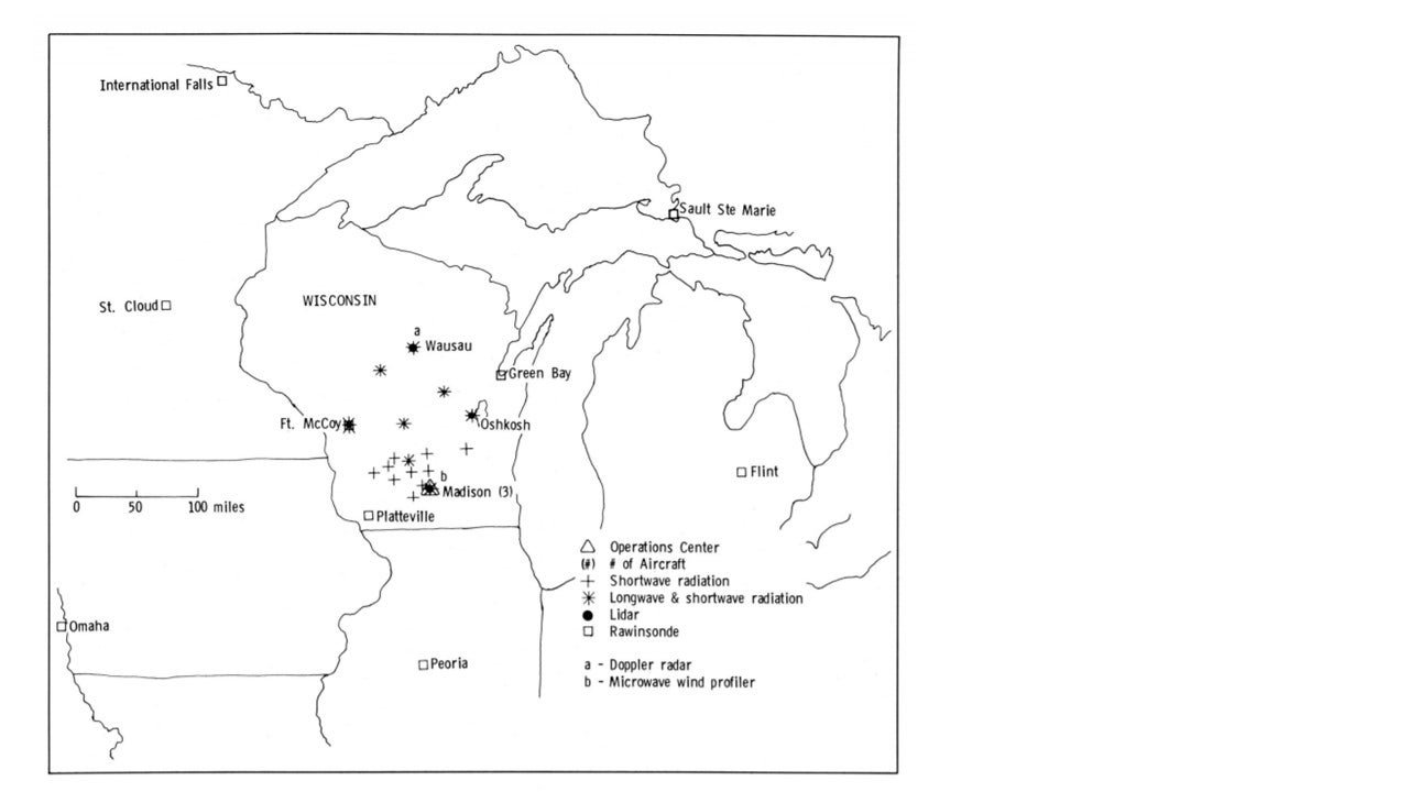
FIRE utilized cloud lidars in combination with conventional in-situ observations and a wide variety of coincident satellite observations to provide as complete and accurate a description as possible of a number of regional cirrus events. Satellite data were obtained from operational geostationary and polar-orbiting NOAA satellites and from ERBS, DMSP, and LANDSAT. Four (4) prime surface sites were operated throughout the experiment. An extensive array of radiometric sensors was deployed at these sites, including four (4) sophisticated cloud observing lidar systems. In addition, fourteen (14) passive surface radiation sites were deployed in the project domain. Research aircraft in-situ observations were obtained from two aircraft, the NCAR Sabreliner and King Air, and included detailed microphysical measurements as well as radiometric and meteorological data. Radiometric observations were also made from NASA’s high-altitude ER-2 aircraft. ER-2 Instrumentation also included the Cloud Lidar System, the High-resolution Interferometer Sounder (HIS), and high-resolution scanning sensors. Rawinsonde data (00 and 12 UTC plus special 3-h releases) were obtained from seven (7) National Weather Service (NWS) sites and three (3) special rawinsonde sites.
The Operations Center was located at Madison (Truax Field) with direct real-time access to GOES Satellite data and the standard meteorological database through a link to the McIDAS system located at the Space Science and Engineering Center at UW.
Network Map:
Data:
| Aircraft | NCAR Sabreliner; NCAR King Air; NASA ER-2 |
| Lidar | Madison (UW); Oshkosh (NOAA/ERL); Wausau (U Utah); Ft. McCoy (NASA/LaRC) |
| Microwave Profiler | Madison (Astronautics) |
| Radiometers (aircraft) | NCAR Sabreliner; NCAR King Air; NASA ER-2 |
| Radiometers (surface) | Madison (Purdue/CSU); Oshkosh (CSU); Wausau (Columbia U); Ft. McCoy (NASA/LaRC); Fourteen (14) passive surface radiation sites (NASA/LaRC) |
| Satellite | NOAA Polar Orbiters (2) - AVHRR, GAC, TOVS |
| Satellite | NOAA Geostationary GOES-6 – VISSR, VAS |
| Satellite | ERBS (ERBE, SAGE II); LANDSAT-TM; DMSP; ISCCP |
| Upper Air | NWS Sites (7) – Green Bay, St. Cloud, International Falls, Omaha, Peoria, Flint, Sault Ste. Marie |
| Upper Air | Special three (3) CLASS rawinsonde sites (NCAR) |
Further information and details on FIRE-Cirrus I can be found at:
FIRE Cirrus Intensive Field Observations 1986 Operations Plans, October 1986
Principal Investigators:
- Kenneth Sassen
- Andrew J. Heymsfield
- Stephen K. Cox
- Bruce Albrecht
Project Manager:
- Erik Miller
- Al Cooper
Data Manager:
- EOL Archive NCAR/EOL/DMS