FIFE-89
Second ISLSCP [International Satellite Land Surface Climatology Project] Field Experiment
Project Description:
The First International Satellite Land Surface Climatology Project (ISLSCP) Field Experiment (FIFE) was an international, land-surface-atmosphere experiment that took place at and around the Konza Prairie Long Term Ecological Research (LTER) site near Manhattan, Kansas starting in 1987. The prairie site itself, roughly 6 km on a side, constituted the northwest portion of the 15-km by 15-km study area (FIFE site). The FIFE site was a controlled experiment site (3487 hectares in area), consisting primarily of native tallgrass prairie vegetation and is one of eleven LTER sites owned by the Nature Conservancy and supported by the National Science Foundation (NSF) with the participation of Kansas State University.
FIFE was an interdisciplinary, coordinated effort, with the cooperation of researchers working in the fields of remote sensing, atmospheric physics, meteorology, and biology. The first year of FIFE (1987), referred to as FIFE-87, consisted primarily of experiment planning and initial field measurement. As a result of the FIFE-87 data analysis, it was decided to return to the FIFE site in late summer of 1989 for a 20-day (24 July through 12 August) Intensive Field Campaign (IFC) known as FIFE-89.
The National Aeronautics and Space Administration (NASA) was the "lead" agency for FIFE, but important contributions were also made by the NSF, the National Oceanic and Atmospheric Administration (NOAA), U.S. Department of Interior, the National Research Council of Canada (NRC), and various universities and research institutes.
Scientific Objectives:
The objectives of FIFE were to better understand the role of biology in controlling the interactions between the atmosphere and the "vegetated" land surface and to investigate the use of satellite observations to infer climatologically significant land-surface parameters. Specifically, the goals of the FIFE-89 IFC were as follows:
Observation of a ‘dry-down’ event: The first priority for FIFE-89 was to monitor changes in the surface energy balance, reflectance, surface temperature, CO2 flux and soil moisture during a ‘dry-down’ period. These data were collected in such a way as to improve the understanding of the critical biological processes and states which influence the surface heat and radiation fluxes and remotely sensed radiometric observations during a transition from wet to dry conditions.
Measurements of the components of the surface CO2 flux: Data were collected to allow a portioning of the total CO2 flux into photosynthesis and respiration components. This was done to make direct correlations between photosynthetic rates and spectral data.
Estimation of the components of surface evapotranspiration: Data were collected to allow an estimation of the soil surface and vegetation canopy contributions to the total surface evapotranspiration rate.
Application of improved techniques: The lessons learned in FIFE-87 were applied during the execution of FIFE-89, particularly with regard to the coordination and design of surface validation measurements and the measurements of turbulent fluxes using airborne eddy correlation equipment.
Observations:
The monitoring program was initiated and continued in a limited form until the end of the growing season of 1989. Data acquired during the year included satellite observations, meteorological network data over and around the FIFE site, and sun photometer data at the FIFE site.
The 15-km by 15-km FIFE site was heavily instrumented with 12 Portable Automated Mesonet (PAM) stations (4 were upgraded with enhanced radiation measurements to ‘Super PAMS’) and 20 flux-measurement stations. The former stations measured components of the radiation budget in addition to the standard meteorological observations while the latter monitored sensible-heat fluxes and latent-heat fluxes and, in some cases, C02 fluxes. Three heavily instrumented ‘super sites’ in the FIFE site were designed to provide observations over various vegetated states: (1) unburned, ungrazed; (2) burned, ungrazed; and (3) burned, grazed. Additionally, soil-moisture mapping, biophysical and biometric measurements, detailed radiometric measurements, and atmospheric soundings (using balloons, SODAR, and LIDAR) were undertaken more or less continuously but with increased efforts during the IFC. Seven aircraft had major roles in the day-to-day execution of FIFE-89. These included the following:
The NASA C-130: This aircraft had two scanners covering the short-wave and thermal regions [Thermatic Mapper Simulator (TMS) and Thermal Imaging Multispectral Scanner (TIMS)], a 21-cm Push Broom Microwave Radiometer (PBMR) and an Airborne Tracking Sun Photometer (ATSP). Additionally, it included an Advanced Solid-State Array Spectrometer (ASAS) that was pointed at ground targets over angles ranging from 45 deg forward to 45 deg aft.
Three Flux (measurement) Aircraft: The flux aircraft included the NCAR King Air, the NOAA Long EZ, and the NRC Twin Otter that measured turbulent fluxes of momentum, sensible heat, and latent heat using eddy correlation equipment. In addition, the Twin Otter and Long EZ also had the unique capability to measure C02 fluxes (area-averaged photosynthesis minus respiration). The King Air and Twin Otter were mainly deployed using the ‘double-stack’ and ‘T-shaped’ flight patterns (similar to FIFE-87), while the Long EZ was principally used to fly series of crosswind legs and the downwind edge of the FIFE site.
The NASA H-l (Huey) Helicopter: The H-l was modified to accommodate a portable mount which allowed the instrument package (radiometers, scatterometer, and cameras) to be moved through the pitch and roll axes. It concentrated on overflights of the flux stations throughout the IFC and gathered multi-angle data over the supersites in coordination with satellite overpasses and surface-based radiometric and biophysical studies. The Soviet spectropolarimeter (Gemma) and infrared radiometer (Mara) were also mounted on the helicopter.
NOAA Aerocommander: The Aerocommander carried the V-ray detector (for derived soil moisture estimates) and flew similar flight lines as in FIFE-87 with additional flight lines over the supersites.
NASA DC-8: The DC-8 was equipped with a L-Band Synthetic Aperture Radar (SAR) that was used to map soil moisture conditions over the FIFE site.
In total, some 71 missions (184.5 hours flight time) were flown by FIFE-89 aircraft over the site. Satellite measurements included the Geostationary Operational Environmental Satellite system (GOES) imagery, Advanced Very High Resolution Radiometer (AVHRR), TIROS Operational Vertical Sounder (TOVS), LANDSAT Thermatic Mapper, and the French Pour l'Observation de la Terre (SPOT). These Satellite data for FIFE were acquired over the site from 1987 through 1989. Other available resources included rawinsondes, SODAR, LIDARs, specialized surface radiometers, photometers (for atmospheric corrections), and equipment for measuring trace-gas fluxes.
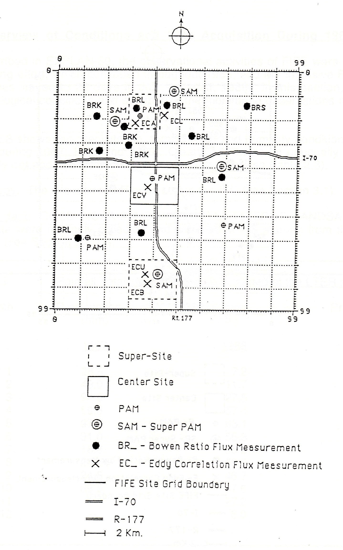
Map of the FIFE site showing the locations of the flux stations and automated mesonet stations as deployed in FIFE-89.
Data:
| Aircraft | NASA C-130; NCAR King Air; NRC Twin Otter; NASA H-1 Helicopter; NOAA Aerocommander; NASA DC-8 |
| Aircraft flux | Flux (detrended, filtered, raw) |
| Biology | Vegetation (photosynthesis rates, leaf properties, plant biomass, root biomass, soil CO2 and gas flux, nitrogen content, species, mowing experiment) |
| Lidar | 2 Lidars |
| Photography | Aircraft aerial photography; surface cloud cameras |
| Profiler | SODAR, NOAA regional profiler data |
| Radiometers | Specialized surface radiometers; Aircraft radiometers; Photometers |
| Satellite | Geostationary GOES imagery |
| Satellite | Polar Orbiting AVHRR imagery; French SPOT imagery; Landsat scenes; TMS imagery; TOVS data |
| Soil | Soil moisture (gravimetric, gamma Ray, neutron, impedance, transect); Soil properties (bulk density, hydraulic conductivity, release, survey reference, thermal conductivity, derived) |
| Surface | 12 NCAR PAM stations (8 standard PAMS and 4 ‘Super PAMS’); 20 flux-measurement stations; Regional routine surface station data (NOAA); Historic surface station data (NOAA) |
| Surface (derived) | Surface fluxes (bowen ratio, eddy correlation, baseline 92) |
| Upper Air | Special rawinsonde releases during IFCs; Regional NOAA routine upper air data |
Further information and details on FIFE-89 can be found at:
Sellers, P.J. and F.G. Hall, 1993: “FIFE-89 Experiment Operations”, 923, NASA/GSFC, Greenbelt, MD 20771.