FIFE-87
First ISLCP Field Experiment
Project Description
The First International Satellite Land Surface Climatology Project (ISLSCP) Field Experiment (FIFE) was an international, land-surface-atmosphere experiment that took place at and around the Konza Prairie Long Term Ecological Research (LTER) site near Manhattan, Kansas. The prairie site itself, roughly 6 km on a side, constituted the northwest portion of the 15-km by 15-km study area (FIFE site). The FIFE site was a controlled experiment site (3487 hectares in area), consisting primarily of native tallgrass prairie vegetation and is one of eleven LTER sites owned by the Nature Conservancy and supported by the National Science Foundation (NSF) with the participation of Kansas State University.
FIFE was an interdisciplinary, coordinated effort with the cooperation of researchers working in the fields of remote sensing, atmospheric physics, meteorology, and biology. The first year of FIFE (1987), referred to as FIFE-87, consisted primarily of experiment planning and field measurement. The National Aeronautics and Space Administration (NASA) was the "lead" agency for FIFE, but important contributions were also made by the NSF, the National Oceanic and Atmospheric Administration (NOAA), U.S. Department of Interior, the National Research Council of Canada (NRC), United States and foreign universities and research institutes, and the US Army Corps of Engineers.
Scientific Objectives:
The objectives of FIFE were to better understand the role of biology in controlling the interactions
between the atmosphere and the "vegetated" land surface and to investigate the use of satellite
observations to infer climatologically significant land-surface parameters. Specifically, the goals of the
experiment and associated research efforts were as follows:
Upscale Integration of Models – The experiment was designed to test the soil-plant-atmosphere models
developed by biometeorologists for small-scale applications (millimeters to meters) and to develop
methods to apply them at the larger scales (kilometers) appropriate to atmospheric models and satellite
remote sensing.
Application of Satellite Remote Sensing – Even if the first goal were achieved to yield a “perfect” model
of vegetation-atmosphere exchanges, it would have very limited applications without a global observing
system for initialization and validation. Accordingly, the experiment was targeted at exploring methods
for using satellite data to quantify important biophysical states and rates for model input.
Observations:
The 15-km by 15-km FIFE site was heavily instrumented with 16 automated meteorological stations and 18 flux-measurement stations. The former stations measured components of the radiation budget in addition to the standard meteorological observations while the latter monitored sensible-heat fluxes and latent-heat fluxes and, in some cases, C02 fluxes during the IFCs. Additionally, soil-moisture mapping, biophysical and biometric measurements, detailed radiometric measurements, and atmospheric soundings (using balloons, SODAR, and LIDAR) were undertaken more or less continuously but with increased efforts during the IFCs. During the Intensive Field Campaigns (IFC)s the heavier resources (in terms of funding and manpower requirements) were committed to the site for the purpose of acquiring a full range of radiometric and flux data during satellite overpasses. Five aircraft had major roles in the day-to-day execution of the experiment. These included the following:
1) The NASA C-130: This aircraft was equipped with two scanners that collected visible, near-infrared, and thermal infrared data in a total of 14 wavelength bands. From its operating height of 16 000 ft above ground level (agl) (4.84 km), the aircraft could "cover" the entire site twice with about 30 percent overlap using six flight lines. The aircraft was also equipped with a sun photometer (for atmospheric corrections), a pointable, linear-array high-spectral-resolution radiometer and a microwave radiometer for soil moisture mapping.
2) Three Flux (measurement) Aircraft: The NCAR King Air and the University of Wyoming (UW) King Air measured turbulent fluxes of momentum, sensible heat, and latent heat using eddy correlation equipment. The NRC contributed its similarly equipped Twin Otter to FIFE-87 for three IFCs. The Twin Otter also had the unique capability to measure C0 2 fluxes (area-averaged photosynthesis minus respiration). Usually, two "flux" aircraft were available per IFC, which allowed for full coverage of
daytime conditions and intercomparison between instruments.
3) The NASA H-l (Huey) Helicopter: The H-l was equipped with a pointable radiometer that recorded visible, nearinfrared, and thermal-infrared radiation reflected or emitted from the surface. A C-band scatterometer was used for soil moisture surveys. The H-l hovering capability provided precisely located nadir and multiangle radiometric data on a nearly simultaneous basis over large areas.
In total, some 170 data missions (over 400 hours flight time) were flown by FIFE-87 aircraft over the site. The satellite data acquired over the site during 1987 was estimated as follows: 5000 GOES images, 1000 NOAA (AVHRR) images, 30 SPOT images and 5 Landsat scenes. Other available resources included rawinsondes, SODAR, LIDARs (2 in IFC-2), specialized surface radiometers, photometers (for atmospheric corrections), and equipment for measuring trace-gas fluxes.
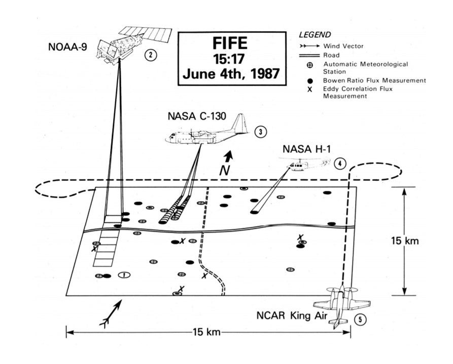 |
Map of the FIFE Study Site (Konza Prairie, Kansas) - Situation at the FIFE site at 15:17, 4 June 1987, which is the time of the NOAA-9 overpass. 1) Surface-flux stations and automatic meteorological stations monitored surface fluxes and near-surface meteorological conditions. 2) NOAA-9 satellite scans the site at 1-km resolution. 3) NASA C-130 traverses the site at 16000-ft AGL taking scanner and sun photometer data. 4) The helicopter hovers above preselected site at 1000-ft AGL and acquires radiometric data. 5) NCAR King Air collects eddy correlation data at 500-ft AGL.
Data:
| Aircraft | NASA C-130; NCAR King Air; UW King Air; NRC Twin Otter; NASA H-1 Helicopter |
| Aircraft flux | Flux (detrended, filtered, raw) |
| Biology | Vegetation (photosynthesis rates, leaf properties, plant biomass, root biomass, soil CO2 and gas flux, nitrogen content, species, mowing experiment) |
| Hydrology | Stream flow (15-min and daily); |
| Lidar | 2 Lidars |
| Photography | Cloud camera |
| Profiler | SODAR, NOAA regional profiler data |
| Radiometers | Specialized surface radiometers; Aircraft radiometers; Photometers |
| Satellite | Geostationary GOES imagery |
| Satellite | Polar Orbiting AVHRR imagery; French SPOT imagery; Landsat scenes; TMS imagery; TOVS data |
| Soil | Soil moisture (gravimetric, gamma Ray, neutron, impedance, transect); Soil properties (bulk density, hydraulic conductivity, release, survey reference, thermal conductivity, derived) |
| Surface | 16 Portable Automated Mesonet (PAM) stations (Army Corps and NCAR); 18 flux-measurement stations; Regional routine surface station data (NOAA); Historic surface station data (NOAA) |
| Surface (derived) | Surface fluxes (bowen ratio, eddy correlation, baseline 92) |
| Upper Air | Special rawinsonde releases during IFCs; Regional NOAA routine upper air data |
Experiment Operations:
The surface meteorological and flux stations operated more or less continuously during IFCs, as did the atmospheric-sounding programs, soil-moisture and biophysical surveys, and surface radiometry efforts. On cloudy days, the C-130 and the helicopter were used for soil-moisture mapping. The most-intensive efforts during the IFCs centered on clear days when good satellite viewing conditions were anticipated. The aircraft were then deployed with the intention of 1) Acquiring radiometric data to compare with the simultaneously acquired satellite and surface radiometric data. In the course of this effort, multiangle data were acquired from which the surface bidirectional-reflectance-distribution function (BRDF) could be reconstructed; and 2) Acquiring airborne (area-averaged) estimates of the fluxes to compare with measurements produced by the combined surface networks and estimates derived from the satellite and airborne-radiometric data. The experimental objectives required that, in order to adequately describe the biological and physical dynamics of the diurnal cycle, four C-130 flights, two or three "flux-aircraft" flights, and two helicopter flights be coordinated with each other and with satellite overpasses within a given 24-hour period.
FIFE-87 had the commitment of 5 science teams to the site for a total of 57 days. The teams (each consisted of a half dozen investigator groups) included: (1) Atmospheric Boundary Layer; 2) Surface Fluxes; (3) Correction and Calibration; (4) Surface Radiances and Biology; and (5) Soil Moisture.
Further information and details on FIFE-87 can be found at:
Sellers, P.J., F.G. Hall, G. Asrar, D.E. Strebel, and R.E. Murphy, 1988: The First ISLSCP Field Experiment (FIFE). Bull. Amer. Meteor. Soc., 69, 22–27, https://doi.org/10.1175/1520-0477(1988)069<0022:TFIFE>2.0.CO;2
Principal Investigators:
- B. L. Blad ( University of Nebraska)
- G. Asrar (Kansas State University)
- Forrest Hall (NASA)
- Robert Dickinson (NCAR)
Data Manager:
- EOL Archive NCAR/EOL