FACE-75
Florida Area Cumulus Experiment
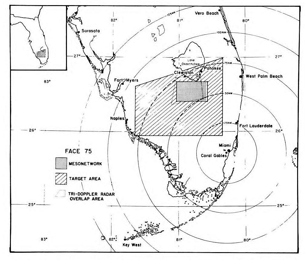
The 1975 Florida Area Cumulus Experiment (FACE-75) began on 16 June and ended on 15 September, 1975, spanning 92 days. It was as ambitious in scope as FACE 1973, but was given somewhat different emphasis, with randomized seeding and other studies over an area of l.3 x l0h km² in South Central Florida (see Network Map below). The design features of FACE included: (1) a fixed target area (see Network Map below) with experiments randomized by day; (2) Surveillance of the clouds in the target area by 10-cm radars with radar estimation of the rainfall (rain estimates adjusted with the use of rain gauges); (3) Determination of suitable days for experimentation on the basis of daily seeding suitability criteria; and (4) targeted flights by seeder aircraft and cloud physics measurements. The 1975 project consisted of a core seeding program and l0 subprograms, including: (1) an ambitious cloud physics program; (2) an elaborate surface network for the measurement of wind, temperature, dew point, pressure and rainfall; (3) a field rawinsonde and Pilot Balloon (PIBAL) effort; (4) mobile, surface rainwater collection and analysis of seeded and unseeded rain; (5) collection of water and aerosol from an aircraft at cloud base on experiment days; (6) a tri-Doppler radar program for the measurement of in-cloud motions; (7) extensive airborne and ground photography; (8) analysis of synoptic-scale conditions on each day; (9) studies of Florida convection with satellite observations; and (10) a public information program.
Active project participants came from within NOAA and other government agencies, and also from the university community. The NOAA groups involved were the National Hurricane and Experimental Meteorology Laboratory (NHEML), the Flight Operations Group (FOG), and the Scientific Instrumentation Group (SIG) of the Research Facilities Center (RFC), the National Hurricane Center (NHC) of the National Weather Service, the Atmospheric Physics and Chemistry Laboratory (APCL), and the Miami Satellite Field Services Station (SFSS). The participants in FACE-75 from the university community were the Division of Atmospheric Sciences of the University of Miami, the Department of Environmental Sciences of the University of Virginia, the Department of Meteorology of the University of Washington, and the Desert Research Institute of the University of Nevada. An aircraft and flight crew also participated from the flight facility of the National Center for Atmospheric Research (NCAR).
NETWORK MAP
 |
PROJECT OPERATIONS
Project operations were coordinated at a Field Operations Site (FOS) located in the Target Area.
The Core Seeding Program consisted of randomized (by days) dynamic seeding of cumulus groups in the FACE target area, with rain volume measured by the calibrated, digitized WSR-57 radar of the National Hurricane Center and then adjusted by rain gages. A total of 33 days of randomized experimentation was obtained (9 on weekends), 24 days (12 seed and 12 controls) on which more than 60 flares were expended and 9 (6 seed days and 3 controls) days on which less than 60 flares were expended. The 24 "GO" days in the former category were comparable to those of past FACE efforts; the 9 GO days in the latter category were days on which the weather deteriorated so that continued experimentation was not warranted. Rainfall over the target area on both types of “GO” days was evaluated and combined with past results, depending upon the pyrotechnic flare expenditure.
The Core Seeding Program of FACE l975 was successful beyond expectations because of favorable weather conditions and the dedication of all participants. During FACE-75, the random sample of “GO” days was doubled on which more than 60 flares were expended, and in this category, the number of days was nearly doubled on which seeding was actually conducted (12 in l975 and 14 in past years). For all FACE experimentation there are 61 “GO” days on which weather conditions warranted the expenditure of more than 60 flares, including 26 seed days, 22 random controls and 13 nonrandom controls.
The weather during FACE 1975 was more favorable than in any past FACE program. The good weather, combined with the dedication and perseverance of all participants 7 days per week, resulted in a program that was successful beyond expectations.
OBSERVATIONS/DATA
Surface mesonetwork - Surface observations were divided into two coincident networks, the rain gage and the mesoscale. The rain gage network was designed to provide ground truth for daily radar - rain gage comparisons to calibrate the digitized WSR-57 radar data. The tipping bucket rain gage network, operated from 15 to 30 June and 1 to 15 September. These 50 gages were on a 2-statute mile spacing, and covered 171 statute square miles. From 1 July through 31 August, this rain gage network was expanded to include an additional 16 rain gages from the C-set systems. This larger network, covered 231 statute square miles.
Doppler Radar Network - Operations was designed to study the in-cloud motion fields with an array of three Doppler radars located near or within the FACE-75 mesonetwork. The two University of Miami radars were installed just north of the mesonetwork at Pahokee (C-band Doppler) and at Clewiston (X-band Doppler). The third radar (C-band Doppler) was installed in the southeast portion of the mesonet and was operated by the NCAR Field Observing Facility. About 10 storms were observed when the three radars were operated simultaneously, mostly in the latter part of August. Also, a chaff release on 22 August from the NOAA DC-6 aircraft was observed by the three radars. Six of the tri-Doppler days were “GO” days on which more than 60 flares were expended; three were seed and three were control.
Upper Air Program - Soundings were used to help describe the synoptic and meso-scale thermodynamic and circulation patterns of the troposphere in and around the surface mesonetwork in FACE-75. There were several sources of soundings giving pressure, temperature, and humidity data. During July, and August, three soundings were taken at 1500, 1800 and 2100 Z at FOS on flight days whenever possible. Typically, on other days an average of two soundings were made from the FOS. In addition, the National Weather Service at Miami International Airport released a special radiosonde at 1800Z during July. A total of 586 thermodynamic soundings were taken, including six dual soundings and four multiple releases from FOS. In addition, 286 pilot balloons were tracked by theodolite (on loan from the University of Virginia) at FOS between the times of the radiosonde balloon releases. The average track lasted 15-min, but was highly variable depending upon local sky conditions.
Ground-based Photography - Every major cloud system in the FACE-75 mesonetwork probably was photographed at least once every 30 minutes during July and August. Clouds outside the mesonetwork are also frequently visible from the surface cameras. The Hasselblad system was at the heart of the photographic coverage, since it took a panorama of the sky every half-hour (826 panoramas, totaling nearly 5000 individual pictures, on most July and August days. Compared to the Hasselblad's regular still-camera views, the three Bolex time-lapse (16mm color) views gave much more detail on the structure and movement of clouds, but only in one direction. Starting on 6 August, one Bolex camera was deployed to each Doppler radar site and looked into the center of the Doppler and mesonetwork areas on most days through 30 August. In addition, hand-held 35-mm slides were taken by personnel in the field.
NCAR's Queen Air Flight Program - A NCAR cloud base aircraft operated in south Florida from 23 June 1975 through 18 July 1975. The aircraft was equipped with the same polypropylene scoop used during the FACE-73 aerosol sampling program, a simultaneous aerosol collection system, a Langer acoustical ice nucleus counter, a nose and two side cameras and all of the standard meteorological instrumentation. A total of 92 clouds was worked during 19 flight dates with 308 rainwater and 405 aerosol samples collected. The aircraft flew a varied set of patterns: (1) In the most predominant pattern, a cloud or cloud complex was continuously penetrated to sample a cloud from its beginning to its dissipation; (2) Aerosol samples were collected just outside cloud or cloud complex perimeters to sample the air in the contiguous zones; and (3) Aerosol samples were collected in vertical stacks from the surface to 10,000 ft to obtain a vertical profile of the aerosol spectrum. In addition, the NCAR Queen Air aircraft flew cloud physics and photography missions in coordination with the NOAA C-130 and DC-6 aircraft.
Surface Collection Program - For the collection of rainwater samples on the surface, a mobile vehicle was positioned under experimental clouds by means of a two-way radio hookup. Simultaneous sets of six filters were collected at the FOS during July.
| Aircraft | NOAA DC-6 and C-130; NCAR Queen Air |
|---|---|
| Model | Trajectories tracking air parcels 5 days back in time for each of the experimental dates at two levels, the layer between the surface and 850 mb, and the layer between 850 mb and 500 mb |
| Radar | University of Miami C-Band and X-band radars |
| Radar | NCAR C-Band radar |
| Radar | NWS WSR-57 radar at Miami |
| Satellite | SMS-1 and SMS-2 imagery every 30-min; LANDSAT 1&2 daily imagery |
| Surface | Special Mesonetwork stations [NCAR (37), U of VA (21) and U of Miami (3)] located in the Target Area |
| Surface | Special rain gauge network (50), measuring daily ave and max rainfall, located in the Target Area |
| Surface | Disdrometer and aerosol samplers located at the FOS |
| Surface | Ground based Photography |
| Surface | Rainwater and chemistry samples from a mobile vehicle and the FOS |
| Upper Air | Special soundings and PIBAL releases from the FOS |
| Upper Air | NWS soundings from Miami (00 and 12 Z, and 18 Z special releases when requested), and Tampa Bay (00 and 12 Z) |
- EOL Archive NCAR/EOL/DMS