ERICA
Experiment on Rapidly-Intensifying Cyclones over the Atlantic
The Experiment on Rapidly Intensifying Cyclones over the Atlantic (ERICA) field study was designed to determine physical mechanisms and processes, and their critical spatial and temporal combinations, which can account for the wintertime phenomenon of explosively developing over-ocean atmospheric storms. Theoretical and numerical modeling research, during the five-year Office of Naval Research (ONR) Heavy Weather at Sea Accelerated Research Initiative ERICA program (1986-1991), comprised a continuing effort, including the field study conducted from 1 December 1988 to 28 February 1989. The ONR core field study was supplemented by the substantial participation of many other agencies and universities from the United States and Canada. Data was obtained over the North Atlantic Ocean from Cape Hatteras to beyond Newfoundland, centered east of Cape Cod and south of Nova Scotia. Measurements in individual rapidly intensifying storms were made from aircraft, buoys, and satellites, and by soundings and radars. The general timing and siting were chosen through consideration of historical storm occurrence data. ERICA in some ways, was considered to be a follow-on to the Genesis of Atlantic Lows Experiment (GALE), and the Canadian Atlantic Storms Program (CASP), both January through March, 1986.
The ONR Marine Meteorology Program was the lead agency in conceiving and funding the ERICA research program. Other major agencies, Institutions, and Universities participating in ERICA included the U.S. Air Force (USAF), National Oceanographic and Atmospheric Administration (NOAA), Canadian Atmospheric Environment Service (AES), National Center for Atmospheric Research (NCAR), Drexel University, and Pennsylvania State University.
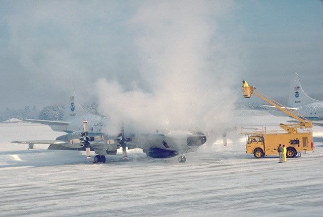
The ground crew de-ices NOAA's P-3 winter storm hunter aircraft in preparation for chasing a Nor'easter that buried the Brunswick, Maine operations base with a foot of snow (Photo courtesy of Weather Underground).
Scientific Objectives:
ERICA consisted of two interacting components: (1) theoretical, numerical-modeling, and analysis studies and (2) field measurements. The acronym "ERICA" had become used equally for the whole program as well as for the 1988-1989 field study.
The specific objectives of the ERICA program were to:
- Understand the fundamental physical processes occurring in the atmosphere during rapid
intensification of winter cyclones at sea, - Determine those physical processes that need to be incorporated into dynamical prediction
models through efficient parameterizations if necessary, and - Identify measurable precursors that must be incorporated into the initial analysis for accurate
and detailed operational model predictions.

Visible satellite image of the ERICA IOP 4 January 4, 1989 cyclone--the most intense winter cyclone ever measured in the central Atlantic (Photo courtesy of Weather Underground).
Observations:
Data were collected over the Region shown in the map below. It consisted of the following facilities and measurement platforms:
Aircraft – Two NOAA WP-3D aircraft were utilized for the new L2D2 dropsonde activity and mid-level and low-level flights including flight level in-situ, cloud microphysics, and Doppler radar data. The NCAR Electra documented details in the Boundary Layer as well as deploying L2D2 dropsondes. The NCAR Sabreliner documented the jet stream and other high-level atmospheric structures near the coast. The Naval Research Laboratory (NRL) P-3 was used for drifting buoy deployment and Omega dropsondes. USAF WC-130s deployed dropsondes. Operational airline meteorological reports (ACARS and ASDAR) were also utilized.
Upper Air – In addition to dropsondes deployed by aircraft, conventional meteorological rawinsonde station soundings were augmented with supplemental National Weather Service (NWS), AES, military Air Weather Service (AWS), and NCAR Cross-chain Loran Atmospheric Sounding System (CLASS) soundings. Wind Profilers from Pennsylvania (McAlevy’s Fort and Crown) and Massachusetts (Otis AFB) were also utilized.
Remote Sensing – Satellite imagery, soundings, derived winds, and sea surface temperature included data from the NOAA Geostationary Operational Environmental Satellite system (GOES), NOAA Polar Orbiting, and Defense Meteorological Satellite Program (DMSP). Remote sensing data were also collected from conventional NWS and AES ground-based radars and the Air Force Geophysical Laboratory (AFGL) Doppler radar.
Buoys – Networks of existing moored buoys were augmented by AES, Woods Hole Oceanographic Institute (WHOI), and Bedford Institute of Oceanography (BIO), and ARGOS satellite linked drifting buoys.

Map of the ERICA region - Stippling denotes the area of greatest surface atmospheric pressure falls for ERIC A-type storms. The smoothed Continental Shelf boundary (100 fathoms) and the Gulf Stream mean position (to the south) are also shown.
Data:
| Aircraft | NCAR Electra and Sabreliner; Two NOAA WP-3D; NRL P-3; USAF WC-130s |
| Aircraft | Operational airline meteorological Reports (ACARS and ASDAR) |
| Buoy | Existing moored buoys, augmented by AES, WHOI, and BIO; Drifting ARGOS buoys |
| Profiler | Wind Profilers from Pennsylvania and Massachusetts |
|
Radar |
NOAA WP-3D airborne Doppler radars; Conventional NWS and AES ground- based radars; AFGL Doppler Radar |
| Satellite | Imagery and soundings from GOES, NOAA Polar Orbiting, and DMSP |
| Ship | Routine Ships of Opportunity observations; US Navy ship observations |
| Surface | Conventional surface observations from NOAA and AES; 10 mesonet stations on the southern coast of Nova Scotia; precipitation characterization system near Halifax, Nova Scotia |
| Upper Air | Special dropsondes; Supplemental soundings from NCAR CLASS, NWS, AES, and military (both surface and ship) |
| Upper Air | Conventional operational sounding stations from U.S. and Canada |
Experiment Operations:
Field Operations were directed, and forecasting/nowcasting proceeding, from facilities provided by the National Meteorological Center (NMC) and National Environmental Satellite, Data, and Information Service (NESDIS) at Camp Springs, MD, and from the Maritimes Weather Centre (MWC) at Bedford, Nova Scotia. The Naval Air Station Brunswick, Maine, was the base for aircraft operations with the exception of the U.S. Air Force WC-130s flying National Winter Storms Operations Plan (NWSOP) reconnaissance missions. Eight (8) Intensive Observation Periods (IOPs) were conducted during ERICA with additional special observation periods with Limited measurements (LOPs). All of the data collected during ERICA was archived at the ERICA Data Center (EDC) at Drexel University.
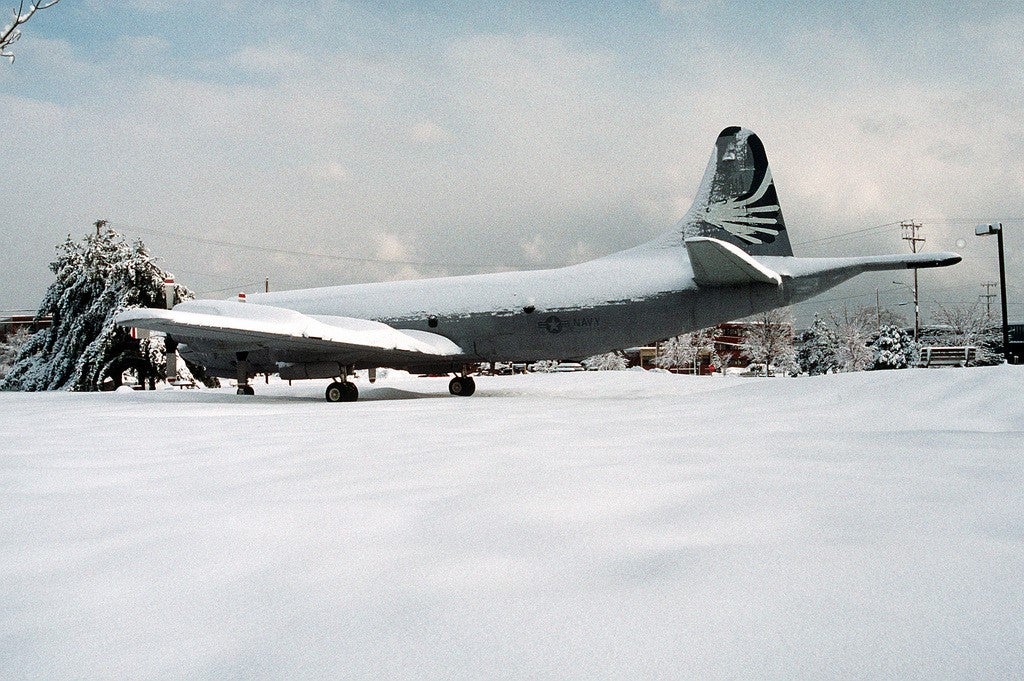
A snow covered P-3C Orion aircraft of Patrol Wing Five, Patrol Squadron 23 (VP-23), the Seahawks, parked on the tarmac at Naval Air Station Brunswick following a winter snow storm (photo courtesy of Picryl.com).
Further information and details on the ERICA Program and field study can be found at:
Hadlock, R. and C.W. Kreitzberg, 1988: The Experiment on Rapidly Intensifying Cyclones over the Atlantic
(ERICA) Field Study: Objectives and Plans. Bull. Amer. Meteor. Soc., 69, 1309–1320,
https://doi.org/10.1175/1520-0477(1988)069<1309:TEORIC>2.0.CO;2